
 IMPACT OF LAND USE AND COVER ON GROUNDWATER QUALITY, CHALLENGES OF SCARCITY AND CONTAMINATION FOR WATER MANAGEMENT IN BRAZILIAN SEMI-ARID CITIES
Abstract
Groundwater is strategic for socio-economic development, especially in semi-arid environments where, in many cases, it is the only viable resource for domestic supply and various economic sectors. In the city of Apodi, in the Brazilian semi-arid region, located in the recharge area of the Açu aquifer, groundwater is used for multiple purposes, but primarily for domestic supply. This work sought to study the relationship between the use and coverage of urban land and water quality, identifying qualitative limitations, sources, and types of contamination for water use in domestic supply. To this aim, wells and potentially contaminating sources were registered, physical and chemical parameters of water samples from 26 wells were collected and analyzed. The data were discretized using ordinary kriging, which made it possible to identify the relationship between the most consolidated urban area and nitrate contamination, which reached 34.6% of the wells analyzed. This points to the risk of qualitative scarcity of this important resource, mainly due to the lack or deficiency in the collection and treatment of domestic effluents.
Keywords:
Aquifers; Environmental Contamination; Domestic Effluents; Nitrogen Compounds
Resumo
A água subterrânea é estratégica para o desenvolvimento socioeconômico, principalmente em ambientes semiáridos onde, em muitos casos, é o único recurso viável para o abastecimento doméstico e de diversos setores econômicos. Na cidade de Apodi, no semiárido brasileiro, localizada na área de recarga do aquífero Açu, a água subterrânea é utilizada para múltiplos fins, mas principalmente para o abastecimento doméstico. Este trabalho buscou estudar a relação entre o uso e cobertura do solo urbano e a qualidade da água, identificando qualitativamente as limitações, fontes e tipos de contaminação para o uso da água no abastecimento doméstico. Para tanto, foram cadastrados poços e fontes potencialmente contaminantes, coletados e analisados parâmetros físicos e químicos de amostras de água de 26 poços. Os dados foram discretizados por meio de krigagem ordinária, o que permitiu identificar a relação entre a área urbana mais consolidada e a contaminação por nitrato, que atingiu 34,6% dos poços analisados. Isso aponta para o risco de escassez qualitativa desse importante recurso, principalmente devido à falta ou deficiência na coleta e tratamento dos efluentes domésticos.
Palavras-chave:
Aquíferos; Contaminação Ambiental; Efluentes Domésticos; Compostos Nitrogenados.
Resumen
Las aguas subterráneas son estratégicas para el desarrollo socioeconómico, especialmente en entornos semiáridos donde, en muchos casos, son el único recurso viable para el abastecimiento doméstico y de diversos sectores económicos. En la ciudad de Apodi, en la región semiárida brasileña, situada en la zona de recarga del acuífero de Açu, el agua subterránea se utiliza para múltiples fines, pero principalmente para el abastecimiento doméstico. Este trabajo buscó estudiar la relación entre el uso y la cobertura del suelo urbano y la calidad del agua, identificando limitaciones cualitativas, fuentes y tipos de contaminación para el uso del agua en el abastecimiento doméstico. Para ello, se registraron pozos y fuentes potencialmente contaminantes, se recogieron y analizaron parámetros físicos y químicos de muestras de agua de 26 pozos. Los datos se discretizaron mediante kriging ordinario, lo que permitió identificar la relación entre la zona urbana más consolidada y la contaminación por nitratos, que alcanzó el 34,6% de los pozos analizados. Esto apunta al riesgo de escasez cualitativa de este importante recurso, debido principalmente a la falta o deficiencia en la recogida y tratamiento de los efluentes domésticos.
Palabras-clave:
Acuíferos; Contaminación Ambiental; Efluentes Domésticos; Compuestos Nitrogenados
INTRODUCTION
Among the water available on earth for use by society, groundwater represents the largest accessible reserve of fresh water (Bassoi 2005), making it even more important for life in arid and semi-arid regions, where surface water and rainfall are limited (Li et al. 2017). Given the natural and socio-economic constraints of water scarcity, underground reserves are strategic in terms of water security for domestic supply.
In Brazilian cities, the supply-demand is around 496.2 m3/s, corresponding to 23.8% of the consumptive use of water resources (Ana 2019). Additionally, over 40% of these cities receive water solely from groundwater (Ana 2021). Thus, many Brazilian municipalities have relied on groundwater for their urban water supply; in some of these, it is the only source available.
However, population and economic growth, as well as land use and occupation, are factors that directly affect groundwater quality (Jiang et al. 2009; Rao et al. 2021). This corroborates with Jeong (2001 pp 1) when he reports that que “The rapid urbanization and population increase has modified land use patterns and increased water demands”. This increase in the demand for water for constructive uses, coupled with the less qualitative availability of water due to pollution and contamination, explains a trend towards increasing water scarcity. Increased concentrations of magnesium, sodium, potassium, chloride, sulfate, nitrate, and fluoride, among others, in groundwater (Subba rao et al. 2020; Ayejoto et al. 2023), parameters that determine the use of water for human domestic consumption, are intrinsically linked to health risks (Egbueri 2023).
In addition to human land use and land-cover activities, the construction of groundwater collection systems in Brazil often fails to comply with the ABNT-12.212 standards for well construction, creating a risk of pollution or contamination of groundwater. Wells without a construction license or even a permit, associated with activities that potentially generate pollutants and the absence of sanitary sewage, are potentially contaminating sources because they facilitate the entry of potentially contaminating substances into the water system. These substances can alter the chemical composition of groundwater, which is determined by a series of processes, including atmospheric input, the interaction of water with soil and rocks, and the input of effluents derived from human activities (Jeong 2001).
Qualitative changes in groundwater can threaten human health and ecosystems, becoming a significant problem (Jiao, Befus, Zhang 2024) that can become irreversible (Wang et al. 2012). This picture becomes even more taciturn in poor regions with semi-arid climates, as Barakat et al. (2020) observed in Morocco, Zhang et al. (2020) in a semi-arid region of China, and Tôrres (2023) in a small town in semi-arid Brazil.
The city of Apodi is entirely supplied by groundwater and overlies a recharge area for the Açu aquifer. As a result, the expansion of the urban sprawl is a cause for concern, especially about the volume of domestic, industrial, and service effluents that are being incorporated directly into the Aluvião-Açu aquifer system. According to Peixoto et al. (2022), the occupied area of the city of Apodi has grown by 126% in the last 30 years. Thus, it is estimated that the increased volume and dispersion of domestic effluents, as well as gas stations, cemeteries, and others, are acting as potential sources of groundwater contamination (Naik et al. 2022).
This research aimed to study the relationship between the use and coverage of urban land and water quality, identifying qualitative limitations, sources, and types of contamination for water use in domestic supply. In addition, self-supply is demonstrated in small towns in the semi-arid region because of the lack of conventional water supply. This work aims to contribute greater visibility and importance to the risk of aquifer contamination in the planning process of small towns, making it possible to delimit the space for future restrictive and corrective actions in land use and occupation to conserve groundwater and manage urban aquifers.
MATERIALS AND METHODS
CHARACTERIZATION OF THE STUDY AREA
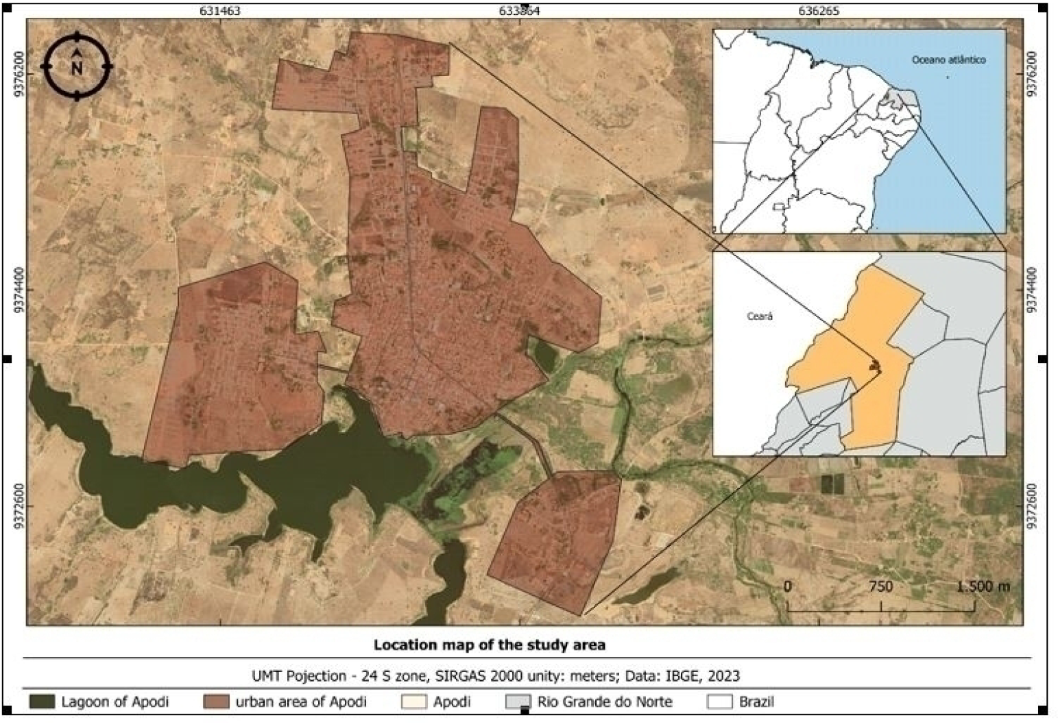
The municipality of Apodi is in the west of the state of Rio Grande do Norte, in the immediate and intermediate region of Mossoró (IBGE, 2018), under a semi-arid climate, characteristic of the northern part of the Brazilian semi-arid region (Condel 2017). The municipality's urban area (Figure 1) covers a territory of 1,60 km2.
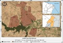
In the geological context, the study area in the municipality of Apodi is located on the southwestern edge of the Potiguar Sedimentary Basin, whose geological evolution is associated with the process of formation of the Atlantic Ocean between 140 and 100 million years ago. The Potiguar Basin evolved from precursor extensional efforts in an E-W direction, causing crustal stretching with high rates of mechanical subsidence of the basement (Pessoa Neto et al. 2007). Its structural framework includes the following features: internal highs, grabens, and shallow platforms, in response to mechanical subsidence. The highs of the emerged portion are defined by the large, asymmetrical structural lineaments in a NE-SW direction.
The climate of the study area is characterized as a semi-arid equatorial tropical climate, with high temperatures, averaging 28.1 ºC, a maximum of 36.0 ºC, and a minimum of 21.0ºC (IDEMA 2008). According to the climate classification method created by Köppen and Geiger, the region's climate is of the hot semi-arid BSs'h type, with two well-defined seasons, one rainy and the other dry (Lima 2007). The basin has two main aquifer systems: the Apodi Aquifer System and the Alluvial Aquifer System (Peixoto and Dias 2022). The former, which includes the city of Apodi/RN, is made up of two main aquifers: one karstic, represented by the Jandaíra aquifer, and the Açu aquifer, which is porous in nature (Diniz Filho and Morais Filho 2010; Peixoto and Dias 2022).
The average rainfall in the area studied, based on data from the Agricultural Research Company of Rio Grande do Norte - EMPARN, over the last 20 years (2001-2021), is 567.85 mm and the median is 657.0 mm/year. In addition, Tôrres and Carvalho (2022), studying 20 years of rainfall between 2000 and 2019, found that the study area is in a homogeneous rainfall region between 600mm and 800mm. Thus, there is an irregularity of rainfall over the years in the area studied.
METHODOLOGY
Secondary data were collected in web databases SIAGAS/CPRM, the platform responsible for official data on wells, and 48 wells were registered by March 2022. Spatial indexing was then produced using the data obtained from SIAGAS/CPRM, using UTM coordinates, to construct location maps of pre-existing wells, helping to update and compose the well register in the next stage.
The field stage was subdivided into three parts: updating the wells; identifying potential sources of pollution; and collecting and analyzing water samples from 26 wells. In the first substage, a register of 70 wells was produced, as well as the health situation in the surrounding area, water uses, and their catchment structures. To this end, a well registration form was drawn up and used to help collect information such as geographical coordinates, geological profile, well depth, topographic elevation, well mouth height, and static level, among others of interest to the study. Some equipment was used, such as a GPS receiver, tape measure, and electrosonic static level meter.
In the second sub-stage, the potential sources of contamination were recorded. The most common were cemeteries, solid waste disposal, fuel storage tanks, polluted surface water, and static sewage systems (septic or rudimentary tanks and seepage pits).
Twenty-six of the 70 wells were selected based on the following criteria:
1º. Existence of a technical-constructive and lithological profile;
2º. Wells in working order;
3º. Spatial distribution favorable to the representativeness of the study area;
4º. Easy access to the well;
5. Wells used for urban self-supply.
The physical and chemical parameters were analyzed at the Electrochemistry and Analytical Chemistry Laboratory (LEQA) of the State University of Rio Grande do Norte (UERN) (Table 1).
Next, to better process and understand the data obtained in this research, the data was entered into a Geographic Information System - GIS, using QGis software version 3.4 'Madeira' (Qgis development team 2022). According to Oksuztepe and Yildirim (2024), a GIS can be understood as a computer system that can collect, manage, operate, analyze, simulate, and display geographic data in large quantities and dimensions, with interconnected themes that, when processed, generate information, aiming at a better spatial discussion for each parameter.
The Piper Diagram was used to model water quality, classifying the chemical type of water according to its dominant ionic content. This was done using the Qualigraf 2.0 software (Mobus 2003). Descriptive statistics were analyzed using Boxspot (tables) to understand the minimum, maximum, and anomalous values; bivariate (2-parameter relationship). The multivariate analysis was produced using the principal component analysis (PCA) method, to understand the correlation between the ions present in the groundwater and the potential sources of contamination. This exploratory data methodology has been used in groundwater quality studies, such as Laureano et al. (2020), Peixoto and Cavalcante (2021), Gomes and Nascimento (2021).
Therefore, after testing the normality of the data, factor plans 1, 2, and 3 were considered, in which the representativeness identified by the accumulated frequency was greater than 70% of the variance, according to Sousa & Sousa (2000), the acceptable proportion threshold (Table 2).
Finally, we made a nitrate pollution index (NPI). NPI is a technique for assessing the groundwater nitrate pollution level. The maximum allowed level of threshold value of nitrate in groundwater is 20 mg/L. According to Ramalingam et al. (2022) the concentration that exceeds the threshold value is considered NO3- contaminated groundwater. The following equation proposed by Obeidat et al. (2012) was used to evaluate NPI in groundwater:
In which NIP this is Nitrate pollution index, and HAV is the limit value for nitrate due to anthropogenic activities and is considered to be 20 mg/L, and Cs is the nitrate concentration of the groundwater samples. In addition, Obeidat et al. (2012) suggests that water quality is classified into five categories based on NPI values. NPI 0 to 1 grouped as unpolluted, 1 to 1.5 as little pollution, 1.5 to 2 as moderate pollution, 2 to 2.5 as high pollution, and above 2.5 as very high pollution.
RESULTS AND DISCUSSION
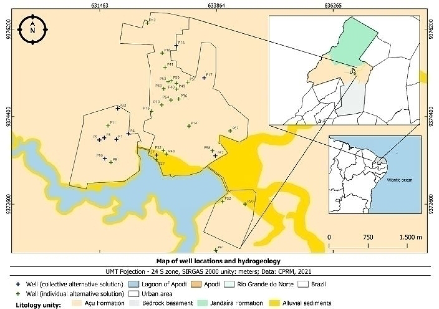
Alternative supply systems - SAA, either an Individual Alternative Solution - SAI (type of water supply for human consumption that serves residential households with a single family, including their households) or Collective Alternative Solution - SAC (collective supply modality designed to provide drinking water, without a distribution network), as mentioned in Ministry of Health ordinance 888/2021, account for 48.53% of the wells studied. This is due to the absence of a conventional supply system in some parts of the city, so 10 wells were built as a SAC and 24 wells as an SAI (Table 3).
Alternative supply systems - SAA, either an Individual Alternative supply systems - SAA, either an Individual Of these wells, P32 and P50 draw water from alluvial deposits and the others from the Açu Formation hydrogeological unit (Figure 2).
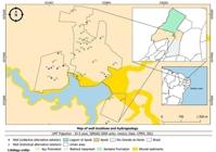
Furthermore, this lack of a conventional water supply means that alternative solutions are sought, as is the case in small towns in the Brazilian semi-arid region (Tôrres 2023), and this, coupled with the lack of updated well registers are factors that can corroborate the risk of contamination.
In this sense, 48 wells were identified in the pre-field stage using secondary data from SIAGAS/CPRM, but of these, only 8 were identified on-site. In the field research, a further 62 were identified, totaling 70 wells. It should be noted that some wells were located outside the urban perimeter (P12, P21, P22, P23, P24, P46, P47, P61) but were considered in this research as they are being used to supply the city's population.
Determining the quality of groundwater is directly associated with the geological substrate, as water percolates into the subsoil incorporating by-products of interaction with the rocks. Furthermore, groundwater can be altered by the addition of substances that directly or indirectly alter a body of water (Custódio and Llamas 1983; Von Sperling 2014). In this context, hydrochemistry reveals the influence of both geological formation and anthropogenic action (Lucon et al. 2018).
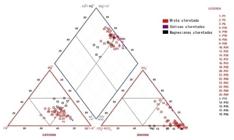
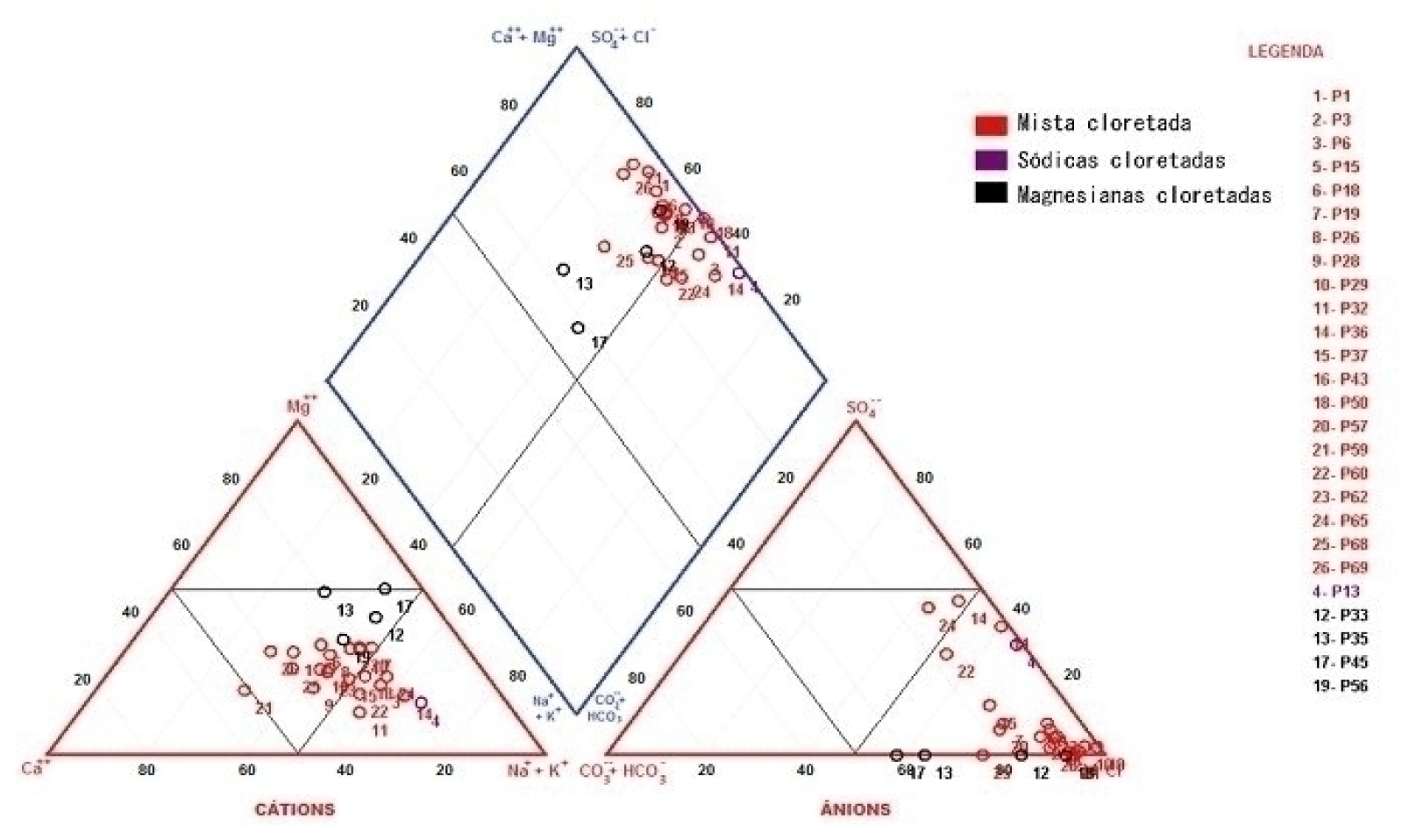
A hydrochemical characterization of the wells was carried out using Piper diagrams of the concentrations of the dominant ions. The Piper diagram (Figure 3) allowed them to be classified into three classes: mixed chloride waters (80.77%), magnesian chloride waters (15.39%), and sodium chloride waters (3.84%).
The deepest well among those studied, P15 (125 meters deep) showed good indices for almost all the parameters, however, the concentrations of TDS and turbidity exceeded the VMP in legislation 888/2021 of the Ministry of Health - MS, showing 655 mg L-1 and 21.7 uT respectively. On the other hand, the shallow wells showed more indices above the VMPs, for example, P50 (17 meters deep) with 4 indices that exceeded the limit: 1833 mg L-1 for TDS, 643.3 mg L-1 for Cl-, 287.8 for NO3- and 7.5 uT for turbidity (Table 4). It can be inferred that shallow wells are more impacted by contamination, as they capture the more superficial sectors of the aquifer, while deeper wells generally capture the lower waters of the aquifer.
Concerning pH, 80.76% are neutral, with an average value of 6.35. On the other hand, 11.56% of the waters is acidic and 7.70% alkaline. The lowest pH value obtained in the analysis was 4.3 and the highest was 7.6, with an average of 6.3, median of 6.4, and standard deviation of 0.74. The levels presented show that 12% of the water is unfit for distribution for human consumption, since according to the Ministry of Health's Consolidation Ordinance Nº. 5, the range of values for water distribution for potability is between 6.0 and 9.5.
The main factors responsible for alkalinity in bodies of water are bicarbonate (HCO3-), carbonate (CO32-), and hydroxide (OH-), which have a buffering effect on the pH of the water. The indices for alkalinity are based on the presence of bicarbonate, which is formed by the action of carbon dioxide (which comes into contact with the atmosphere from the upper layers of the soil and from the chemical and biological reactions that take place in this environment) on basic materials such as calcium and magnesium carbonates (Sawyer and Mccarty 1978; Feitosa et al. 2008; Souto et al. 2014). The following chemical reaction exemplifies this process:
In this context, the highest pH levels are generally found in waters with a predominance of Ca2+ and Mg2+ ions, or waters rich in bicarbonates, Ca2+, and Na+, as seen by Gomes (2013). Thus, acidic pH has a higher concentration of carbon dioxide, at pHs between 7 and 9 there are higher levels of bicarbonate, and from pH 8.3 onwards there is carbonate (Dublen and Steinhauser, 2011). This was also observed in this study, as the highest pHs were found in wells P37 and P60, both with the highest HCO3levels of 30 mg L-1 and mg L-1, respectively.
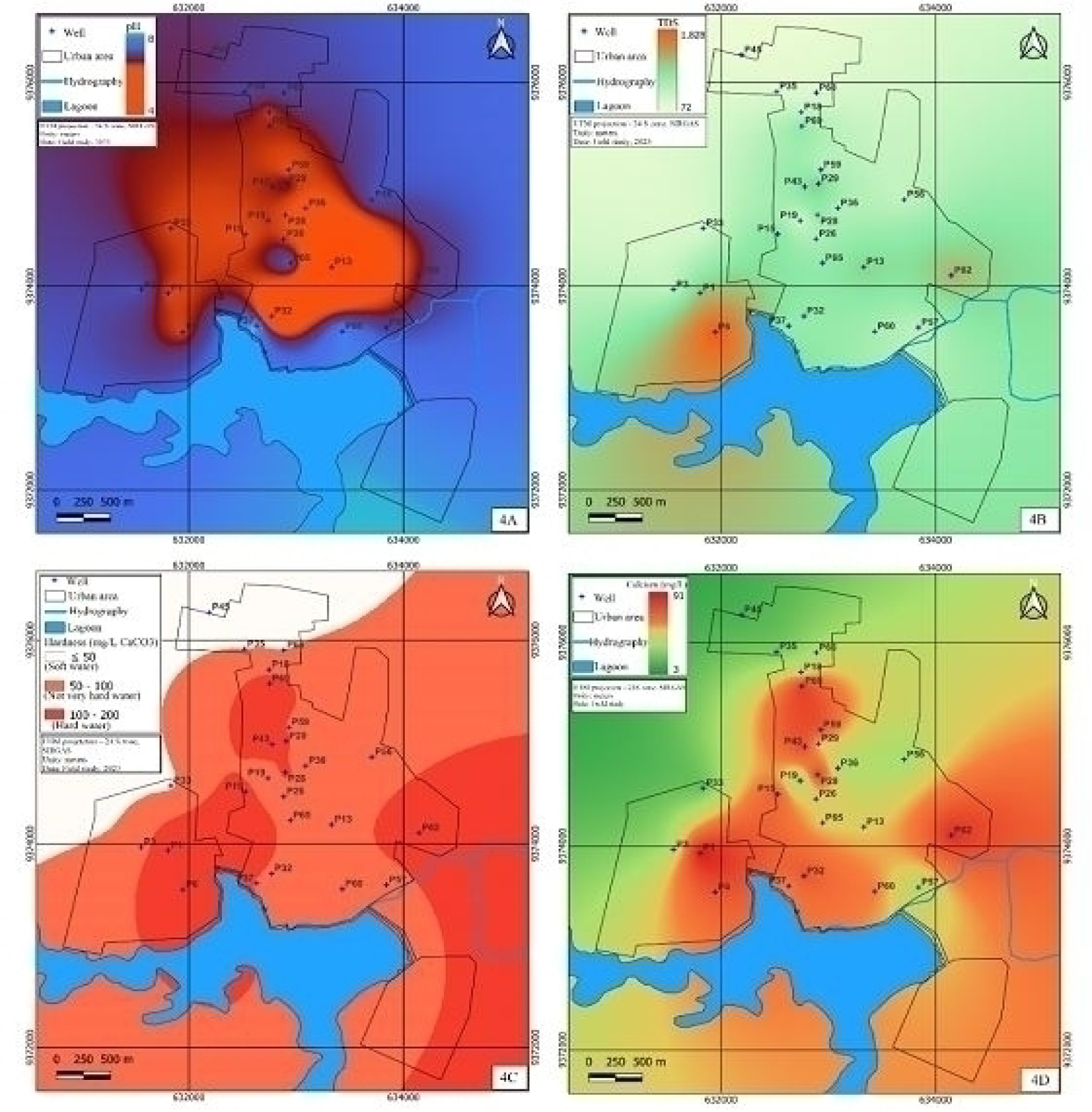
The waters of these two wells, with pH values close to 8.0, have an alkaline to strongly alkaline reaction and are on the banks of the Apodi Lagoon. These waters may be hydraulically connected to the lagoon water due to their proximity to the reservoir, which, according to Lemos, Ferreira Neto and Dias (2010), has a pH close to 8.0. On the other hand, the lowest pH values are found in the more central/consolidated areas of the city (Figure 4A), possibly affected by nitrogen oxidation as a result of NO3- contamination.
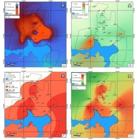
Zoning of parameters: (A) Zoning of pH; (B) Zoning of TDS; (C) Zoning of Hardness; (D) Zoning of Ca+
STD values ranged from 71 mg L-1 to 1,833 mg L-1 (Figure 4B). The sample mean was 552.2 mg L-1, the median was 512 mg L-1, and the standard deviation was 378.42 mg L-1. 57.69% of the waters studied had total dissolved solids above the limit allowed (500 mg L-1) by Ministry of Health Ordinance 888/2021. Spatializing the data (Figure 5B) showed that the highest concentrations of TDS were found in wells P6 (1,323 mg L-1) and P50 (1. 833 mg L-1), where the lithological conditions are more vulnerable to salt percolation, as it is an alluvial aquifer, and to salt leaching, which tends to accumulate near the Apodi Lagoon, areas at the base level of erosion, where sediments and leached salts are transported (Tôrres 2023).
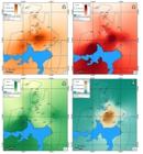
Zoning of parameters: (A) Zoning of Na+; (B) Zoning of K+; (C) Zoning of Cl-; (D) Zoning of SO42-
In terms of total hardness, according to the classification by Custódio and Llamas (1993), the area studied had soft waters (7.69%) in the north, slightly hard waters (57.7%) in the west, south-central, and northeast, and very hard waters (34.61%) at specific points in the west-central and east of Apodi (Figure 4C). This parameter varied between 27.7 mg L-1 and 169.7 mg L-1; thus, all the waters have hardness within the VMP, which is 300 mg L-1.
Wells P1, P6, P15, P29, P43, P62, and P69 have the highest calcium levels in the area studied (Figure 4D). These wells draw water from the Açu Aquifer and are possibly a calcilutite deposit, characterized by Vasconcelos, Lima Neto and Ross (1990) as Unit III of the Açu Aquifer. Water with a hardness of less than 60 mg/L can be aggressive and cause corrosion phenomena in the water supply system. Conversely, water with a hardness above 180 mg/L of CaCO3 can lead to the formation of incrustations in pipes, as mentioned by Gray (2008, pp 204).
In this study, both the sodium and potassium values were below the maximum values allowed by the Ministry of Health (200 mg L-1 for both).
Sodium - Na+ values ranged from 11.1 mg L-1 to 124 mg L-1, with a mean of 53 mg L-1, a median of 55.1 mg L-1, and a standard deviation of 31.05 mg L-1. Part of the concentration of this ion in groundwater comes from atmospheric precipitation (Gray 2008). However, it may also have partially originated from domestic effluents since the highest values were found in the most consolidated urban area (Figure 5A), and there may be an enrichment of this ion due to human urine, which is rich in sodium.
About potassium (K+) (Figure 5B), concentrations ranged from 9.3 mg L-1 to 100.4 mg L-1. High levels of K+ may be linked to the dissolution of alkaline feldspars (Silva; Migliorini, 2014), present in the Açu Sandstone formation. For human health, ingesting water with excess K+ can have laxative effects (Pires, Vaitsman, Dutra 2007).
Chloride (Cl-) concentrations ranged from 11.1 mg L-1 to 643.3 mg L-1 and their average was in the 3rd quartile, still within the permitted limit, as the maximum permitted value for chloride levels in groundwater is 250 mg L-1, according to MS Ordinance 888/2021. An excess of dissolved chlorides in water can result in a salty taste, as well as damage to metal surfaces and pipes, for example (Cetesb 2020). In the samples studied, 11.53% had levels above the VMP, corresponding to wells P1, P6, and P62, located close to surface water bodies (Figure 5C). This ion can come from rainwater, the geological framework, or even a possible relationship with domestic effluent discharges (Queiroz et al. 2012).
The sulfate ion (SO42-) is one of the forms of sulfur present in groundwater and comes from three main sources: decomposition of rocks; rainfall; and agricultural activity with the application of sulfur-containing fertilizers (Esteves 1988). In addition, this ion can come from sea salt aerosols, which is not the case in the area studied, and from the discharge of domestic sewage and industrial effluents (Sousa, Borges, Pinheiro 2022). It is also worth remembering that this ion can alter the taste of water, between salty and bitter, and have a laxative effect on humans (Jakóbczyk-Karpierz and Slósarczyk 2022). The spatialization of the mentioned ion showed that the highest levels are in the central, consolidated urban area (Figure 5D).
For SO42-, the variation ranged from 4.2 mg/L-1 to 59.9 mg/L-1, all of which were within the VMP allowed for urban supply, which is 250 mg L-1 according to current legislation (Ordinance 888/21) of the Ministry of Health. The average SO42- concentration was 21.7 mg L-1, with a median of 12.2 mg L-1 and a standard deviation of 19.63 mg L-1.
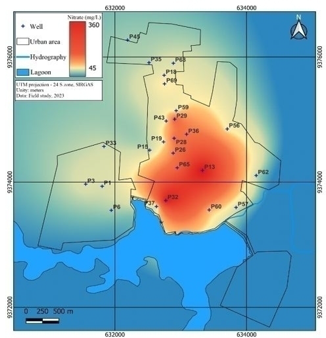
The NO3- values obtained ranged from 2.4 mg L-1 to 371.3 mg L-1, with an average of 81.6 mg L-1, a median of 37.3 mg L-1, and a standard deviation of 106.56 mg L-1. According to Consolidation Ordinance Nº. 5 of the Ministry of Health and the World Health Organization, the maximum permitted amount of nitrate in water is 45 mg L-1. This shows that 34.61% of the samples studied were contaminated by NO3-. It can be seen that nitrate levels are at an average static level of 3 meters or more. The greater depth of the water table favors the concentration of nitrate as the oxidation process takes place in the sub-saturated zone, where oxygen is available (Peixoto and Cavalcante 2021).
This type of contamination can be associated with sewage leakage in urban environments and the deposit of domestic effluents in static sewage systems, represented by rudimentary and septic tanks, which are among the main sources of groundwater contamination by nitrate - NO3- (Montanheiro 2014; Zhang et al. 2015; Grimmeisen et al. 2017; Vystavna et al. 2017 Peixoto and Cavalcante 2021; Abascal et al. 2022).
It is worth noting that the health risks associated with nitrate ions present in water bodies are correlated with diseases such as methemoglobinemia (blue baby syndrome) (Bortoli, Prá, Kunz 2019). In addition, ingesting high concentrations of NO3- can cause birth defects, spontaneous abortions, increased infant mortality, abdominal pain, diarrhea, vomiting, and changes in the immune system (Ebrahimi and Roberts 2013). Another concern with this ion in groundwater is the longevity of the contaminant, which according to Wang et al. (2016) can be stored in aquifers for many years and can affect more than one generation. Analyzing the spatialization of NO3- levels (Figure 6), the highest concentrations are found in the more mature wells, built between the 1950s and 1970s, in the more consolidated urban areas, with septic and rudimentary tanks having been installed and used for longer, as well as some inadequately deactivated wells, which can be a means of contaminating groundwater.
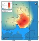
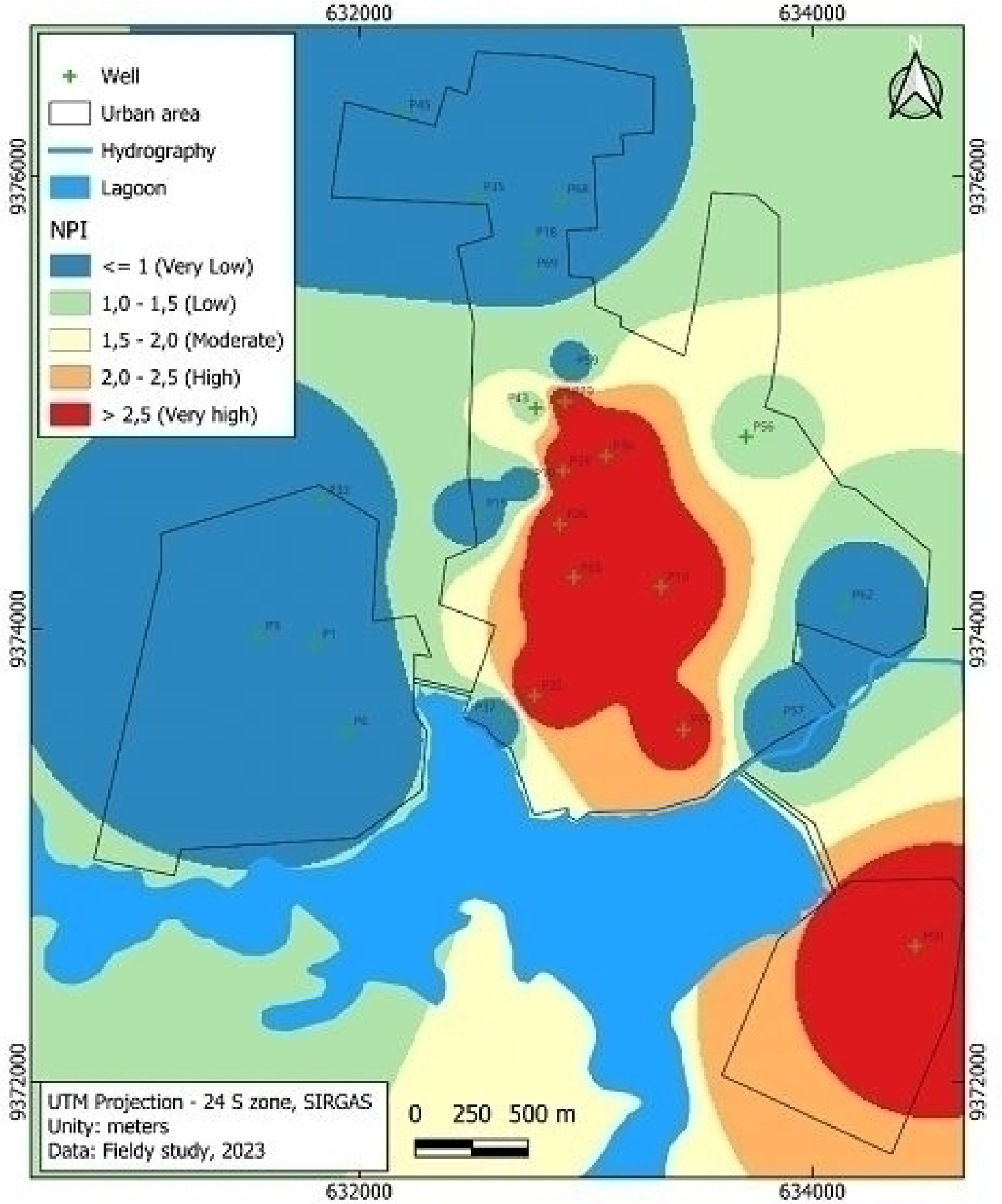
In addition the NPI of groundwater sample were calculated and presented below (Table 3). The NPI classification of groundwater showed that 30.77% of sample is Very high pollution, and 3.85% of sample is High pollution and 11.54% of sample is low pollution in the study region. It can thus be seen that 46.16% of the samples have significant nitrate pollution values (Figure 7).
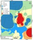
The NPI spatialization shows use and covers city consequences. It means the rudimentary cesspit, associated with zones most densely populated in the city center. In the southeast area, the very high NPI is probably associated with diffuse residues of agriculture, basically nitrogen fertilizers.
Zones appointed by high NPI are areas with contamination that require actions to mitigate nitrate concentrations. The immediate control of contamination sources is the most important action that must be realized through public policies.
When coss-checking the data between factorial plan 1 - F1 and factorial plan 2 - F2, an inverse relationship between pH values and NO3- levels is noticeable (Figure 8). During oxidation to nitrate, H+ ions are produced, so the incorporation of H+ into the water lowers the pH (Hem 1985). Peixoto and Cavalcante (2021) also found an inversely proportional relationship between nitrate in the nitrogen form, N-NO3-, and pH.
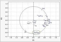
Some of the lower pH values are possibly water contaminated by nitrates from domestic effluents that are not sanitary and are thrown into rudimentary pits. This is reported by authors such as Hem (1959), who says that the decrease in pH has a biogeochemical relationship with contamination by nitrates - NO3-; Liu, Wang and Jang (2013) suggest that increases in NO3- cause acidification of waters and Peixoto and Cavalcante (2019) when they considered that the nitrification mechanism causes a decrease in pH.
This nitrification mechanism involves the consumption of oxygen, the release of H+, and a reduction in the pH of the water (Hem 1959; Torre 2004). In this context, the higher the nitrate concentration, the lower the pH. The nitrification process is understood as the oxidation of ammonium ions to nitrate by bacteria, Nitrosomonas, and Nitrobacter, which do not require an organic substrate for their growth (Chen, Ling, Blancheton 2006).
In water bodies, the oxidation of NO2- to NO3- occurs at an accelerated rate, which explains the low concentration of NO2- in groundwater. When it is present, it may indicate recent contamination. This accelerated process is promoted by the bacterium Nitrobacter.
In this study, it was found that pH values below 6 are better associated with NO3- contamination. The most acidic wells, P13 (pH 4.35), P32 (5.08) and P50 (4.30) have NO3- concentrations of 551.1, 353.4, and 547.5 respectively. The WHO (2012) has a maximum permissible value (MPLV) of NO3- of up to 45 mg/L, so these wells are 12.25 (P13), 7.85 (P32), and 12.17 (P50) times above the MPLV, proving contamination by NO3-.
Another association was also seen when cross-referencing the data from the aforementioned factorial plans between HCO3- and alkalinity. As explained by Hem (1985), the alkalinity of water is its ability to neutralize acids and can indicate the buffering capacity (resistance to pH changes) of the medium.
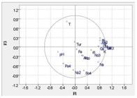
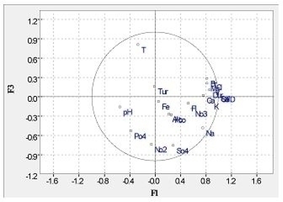
Analysis of factor plan 1 - F1 and factor plan 3 - F3 (Figure 9) shows that there is an association between nitrite and phosphate. This is indicative of recent contamination from septic tanks, since in a natural water environment the oxidation of NO2- to NO3- occurs rapidly. Phosphate can have a natural origin, due to the leaching of minerals (depending on the characteristics of the rocks in the region) and/or the decomposition of biological material, but it can also have an anthropogenic origin, leading to the percolation of wastewater or water that has not been properly treated.
CONCLUSION
Rapid urbanization and population growth have changed land use patterns, which are factors that directly affect groundwater quality while increasing water demand. In the context of the semi-arid region, with naturally scarce conditions, groundwater is a strategic reservoir and an increase in its use without effective control can lead to quantitative and qualitative scarcity.
The main potential sources of groundwater contamination in the city of Apodi are rudimentary cesspits and septic tanks, which receive all the effluent generated by the inhabitants of Apodi. However, the following are also listed as potential sources of water contamination in the saturated zone in the city studied: car washes, gas stations, cemeteries, and industries.
The Açu aquifer is found in most of the urban area of the municipality of Apodi. In addition, the city is located over an aquifer recharge area, so the expansion of the urban sprawl is a cause for concern, especially in terms of the volume of effluent that is being incorporated directly into the Alluvial and Açu aquifers, since domestic sewage contains a large quantity of organic compounds and is highly variable in composition, which, when left untreated, can cause contaminants to persist in groundwater sources.
The water quality parameters were discussed based on the analysis of 26 wells, in which some parameters were above the Maximum Permitted Value - VMP by Consolidation Ordinance Nº. 5/2017 of the Ministry of Health - MS, such as pH (12%), STD (57.69%), Chloride (11.53%), Nitrite (3.84%) and Nitrate (34.61%). This last ion can be harmful to health by causing water-borne diseases such as blue baby syndrome and, with this in mind, we draw attention to the fact that its concentration is higher in the consolidated urban area, reflecting the effect of poor sanitary quality and population concentration throughout the neighborhoods, i.e. the more consolidated the area and without sanitary sewage, the higher the levels of this element.
In the Principal Component Analysis (PCA), which sought to identify the associations between the ions analyzed in the waters to analyze their quality, an inverse relationship was observed between pH values and NO3- levels. Thus, the more acidic the waters, the higher the nitrate concentrations in the groundwater.
The results point to the difficulty in supply, complemented by collective and individual supply solutions which, when poorly designed, can directly corroborate the contamination of groundwater and consequently the risk, especially for the population that uses self-supply via alternative solutions.
In this context, the work contributes greater visibility and importance to the risk of contamination of aquifers in the planning process of small towns in the semi-arid region, delimiting the space for future restrictive and corrective actions in land use and occupation to conserve groundwater. The data and information produced also contribute to geographical science with regional studies and will possibly help to define more sustainable strategies for the use of groundwater resources, producing subsidies for actions to conserve the quality of groundwater in the Açu aquifer.
In general, with a view to water management that aims to preserve the main source of water supply for the inhabitants of the municipality of Apodi, in the Brazilian semi-arid region, and an important recharge area for the Açu Aquifer, it is recommended that legal technical bases be used to recover the qualitative aspects of groundwater in the management of these water resources. To this end, we suggest using environmental education programs, updating the registry, and making a quantitative and qualitative diagnosis of the wells.
In addition, a survey of potential sources of pollution/contamination, integrated with georeferenced bases prepared using Geographic Information Systems (GIS), can support effective decision-making in restricting urban land use, implementing sewage collection and treatment, and controlling potentially contaminating sources. Finally, it will contribute to future restrictive and corrective actions in land use and occupation to conserve groundwater.
REFERENCES
- ABNT - Associação Brasileira de Normas Técnicas. NBR 12212/2017: Projeto de poço tubular para captação de água subterrânea - Procedimento. Rio de Janeiro: ABNT, 2017.
- ABASCAL, E.; GÓMEZ-COMA, L.; ORTIZ, I.; ORTIZ, A.. Global diagnosis of nitrate pollution in groundwater and review of removal Technologies. Sci. Total Environ. (2022).
- ANA - Agência Nacional de Águas. Atlas Brasil: abastecimento urbano de água: panorama nacional. Brasília: ANA, 2015.
-
ANA - Agência Nacional de Águas. Atlas águas: segurança hídrica do abastecimento urbano (2021). Brasília (Brasil). http://atlas.ana.gov.br Acesso em 05 de outubro de 2023.
» http://atlas.ana.gov.br - ANA - Agência Nacional de Águas. Manual de usos consuntivos de água no Brasil. Brasília: ANA, 2019.
- AYEJOTO, Daniel A.; AGBASI, Johnson C.; EGBUERI, Johnbosco C.; ABBA, S.I.. Evaluation of oral and dermal health risk exposures of contaminants in groundwater resources for nine age groups in two densely populated districts, Nigeria. Heliyon, 9 (2023) e15483.
- BARAKAT, A.; MOUHTARIM, G., SAJI, R., TOUHAMI, F.. Health risk assessment of nitrates in the groundwater of Beni Amir irrigated perimeter, Tadla plain, Morocco. Hum. Ecol. Risk Assess. (2020)
- BASSOI, L. J., 2005. Poluição das Águas. In: PHILIPPI JÚNIOR, A.; PELICIONE, M. 598 C. F. (ed) Educação Ambiental e Sustentabilidade, 1rd edn. Manole, Barueri, 599 pp 175-194.
-
BORTOLI, M.; PRÁ, M. C. de; KUNZ, A. Tratamento do digestato: remoção de nitrogênio. In: KUNZ, A.; STEINMETZ, R. L. R.; AMARAL, A. C. do (Ed.). Fundamentos da digestão anaeróbia, purificação do biogás, uso e tratamento do digestato. Concórdia: Sbera: Embrapa Suínos e Aves, 2019. p. 129-190. DOI: https://dx.doi.org/10.21452/978-85-93823-01-5.2019.01_6
» https://dx.doi.org/10.21452/978-85-93823-01-5.2019.01_6 - BRASIL. Ministério do Meio Ambiente. Conselho Nacional de Meio Ambiente. Resolução CONAMA nº 396, de 3 de abril de 2008. Dispõe sobre a classificação e diretrizes ambientais para o enquadramento das águas subterrâneas e dá outras providências. Brasília, DF: Diário Oficial da União, 2008.
- BRASIL. Portaria de Consolidação nº 5, de 28 de setembro de 2017. Consolidação das normas sobre as ações e os serviços de saúde do Sistema Único de Saúde. Ministério da Saúde.
-
BRASIL. Portaria GM/MS Nº 888, de 4 de maio de 2021. Altera o Anexo XX da Portaria de Consolidação GM/MS nº 5, de 28 de setembro de 2017, para dispor sobre os procedimentos de controle e de vigilância da qualidade da água para consumo humano e seu padrão de potabilidade. Disponível em https://bvsms.saude.gov.br/bvs/saudelegis/gm/2021/prt0888_07_05_2021.html Acesso em 17 de maio de 2023.
» https://bvsms.saude.gov.br/bvs/saudelegis/gm/2021/prt0888_07_05_2021.html - CASALI, C. A. Qualidade da água para consumo humano ofertada em escolas e comunidades rurais da região central do Rio Grande do Sul. 2008. 173 f. Dissertação (Mestrado) - Curso de Ciência do Solo, Universidade Federal de Santa Maria, Santa Maria - RS, 2008.
- CETESB - Companhia Ambiental do Estado de São Paulo. Qualidade das Águas Interiores no Estado de São Paulo 2020: Apêndice E - Significado Ambiental e Sanitário das Variáveis de Qualidade. São Paulo: CETESB, 2021
- CHEN, S.; LING, J.; BLANCHETON, J.. Nitrification Kinetics of Biofilm as Affected by Water Quality Factores. Aquacultural Engginering, v. 34, p. 179-197, 2006
-
CONDEL - Conselho Deliberativo da Superintendência do Desenvolvimento do Nordeste. Resolução nº 107, de 27 de julho de 2017. Estabelece critérios técnicos e científicos para a delimitação do semiárido brasileiro e procedimentos para a revisão de sua abrangência. Disponível em: https://www.lex.com.br/legis_27508570_RESOLUCAO_N_107_DE_27_DE_JULHO_DE_2017.aspx Acesso em 23 de maio de 2022.
» https://www.lex.com.br/legis_27508570_RESOLUCAO_N_107_DE_27_DE_JULHO_DE_2017.aspx - CUSTÓDIO, E.; LLAMAS, M. R. Hídrologia Subterránea. 2. ed. Barcelona: Omega. 1983. vol. 2.
- DINIZ FILHO, J. B., MORAIS FILHO, A. C., 2010. Potencialidade hidrogeológica do grande do norte. Geodiversidade do estado do Rio Grande do Norte. In: PFALZGRAFF, P. A. S., TORRES, F. S. M., CPRM, Recife.
- EBRAHIMI, S.; ROBERTS, D. J.. Sustainable nitrate-contaminated water treatment using multi cycle ion-exchange/bioregeneration of nitrate selective resin. J Hazard. Mater., 2013, 262, 539-544.
-
EGBUERI, J. C., 2023. A multi-model study for understanding the contamination mechanisms, toxicity and health risks 636 of hardness, sulfate, and nitrate in natural water resources. Environ. Sci. Pollut. Res. https://doi.org/10.1007/s11356-023-26396-5
» https://doi.org/10.1007/s11356-023-26396-5 - EMPARN - Empresa de Pesquisa Agropecuária do Rio Grande do Norte (2024) Relatório pluviométrico por posto. EMPARN, Parnamirim, Brasil.
- ESTEVES, F. de A... Fundamentos de limnologia. Interciência: FINEP Rio de Janeiro-RJ, 1988, 557p.
- FEITOSA, F. A. C.; FILHO, J. M.; FEITOSA, E. C.; DEMETRIO, J. G. A.. Hidrogeologia: conceitos e aplicações. 3ª ed. Ver e ampl. Rio de Janeiro: CPRM/LABHID, 2008. 812p.
- GOMES, M. da C. R.. Análise situacional qualitativa sobre as águas subterrâneas de Fortaleza, Ceará-Brasil como subsídio a gestão dos recursos hídricos. 2013. 2014 f. Tese (Doutorado em geologia) - Universidade Federal do Ceará, Fortaleza-CE, 2013.
-
GOMES, Maria da Conceição Rabelo. NASCIMENTO, Sérgio Augusto de Morais. Caracterização das Águas Subterrâneas no Alto Cristalino de Salvador-Bahia com Auxílio da Estatística Multivariada. Anuário do Instituto de Geociências, 2021, v. 44, 40600 https://doi.org/10.11137/1982-3908_2021_44_40600
» https://doi.org/10.11137/1982-3908_2021_44_40600 - GRAY, N. F.. Drinking Water Quality - Problems and Solutions. 2nd edition, Cambridge University Press, 2008.
-
GRIMMEISEN, F.; LEHMANN, M.F.; LIESCH, T.; GOEPPERT, N.; KLINGER, J.; ZOPFI, J.; GOLDSCHEIDER, N. 2017. Isotopic constraints on water source mixing, network leakage and contamination in an urban groundwater system. Science of the Total Environment, 583: 202-213. https://doi.org/10.1016/j.scitotenv.2017.01.054
» https://doi.org/10.1016/j.scitotenv.2017.01.054 - HEM J. D.. Study and Interpretation of the Chemical Characteristics of Natural Water. U.S.G.S. Water Supply Paper, 1473. 1. ed. 1959. 269 p.
- HEM, J. D. Estudo e interpretação das características químicas da água natural. Departamento do Interior, Serviço Geológico dos EUA, 1985
- HIRATA, R. et al. As águas subterrâneas e sua importância ambiental e socioeconômica para o Brasil. São Paulo: Universidade de São Paulo, 2019.
-
IBGE - INSTITUTO BRASILEIRO DE GEOGRAFIA E ESTATÍSTICA. Regiões de Influência das Cidades 2018 (REGIC). Rio de Janeiro: 2020a. Disponível em: https://biblioteca.ibge.gov.br/index.php/biblioteca-catalogo?view=detalhes&id=2101728 Acesso em: 10 de março de 2022.
» https://biblioteca.ibge.gov.br/index.php/biblioteca-catalogo?view=detalhes&id=2101728 -
IDEMA. Perfil do seu Município: Apodi. 2008. Disponível em: http://www.idema.rn.gov.br/Conteudo.asp?TRAN=CATALG&TARG=61&ACT=null&PAGE=0&PAR M=null&LBL=Socioecon%C3%B4mico>. Acesso em: 18 maio. 2024
» http://www.idema.rn.gov.br/Conteudo.asp?TRAN=CATALG&TARG=61&ACT=null&PAGE=0&PARM=null&LBL=Socioecon%C3%B4mico - JAKÓBCZYK-KARPIERZ, Sabrina. SLÓSARCZYK, Kinga. Isotopic signature of anthropogenic sources of groundwater contamination with sulfate and its application to groundwater in a heavily urbanized and industrialized area (Upper Silesia, Poland). Journal of Hydroly, 618 (2022)
- JEONG, Chan Ho. Effect of land use and urbanization on hydrochemistry and contamination of groundwater from Taejon area, Korea. Journal of Hydrology, Volume 253, Issues 1-4, 15 November 2001, Pages 194-210
- JIANG, X.W.; WAN, L.; WANG, X.S.; GE, S.; LIU J.. Effect of exponential decay in hydraulic conductivity with depth on regional groundwater flow Geophys. Res. Lett., 36 (24) (2009)
- JIAO, Jianying; BEFUS, Kevin M.. ZHANG, Ye. Soil contaminants pose delayed but pervasive threat to shallow groundwater. Journal of Hydrology, 7 (2024).
-
LAUREANO, J. de J.; MENDONÇA, A. G.; LOPES, D. da S.; SOUSA, L. M. de; LIMA, T. de O.; ROSA, A. L. D. da; BASTOS, W. R.; NASCIMENTO, E. L. do. Análise da qualidade da água subterrânea: estudo de caso na microbacia do Igarapé Nazaré (Rondônia, Amazônia ocidental). Águas Subterrâneas, [S. l.], v. 35, n. 1, 2020. DOI: 10.14295/ras.v35i1.29972.
» https://doi.org/10.14295/ras.v35i1.29972. -
LEMOS, M. de, FERREIRA NETO, M., DIAS, N. da S., 2010. Sazonalidade e variabilidade espacial da qualidade da água na Lagoa do Apodi, RN. Revista Brasileira de Engenharia Agrícola e Ambiental. https://doi.org/10.1590/S1415-43662010000200006
» https://doi.org/10.1590/S1415-43662010000200006 - LENZI, Ervim; FAVERO, Luzia Otília Bortotti; LUCHESE, Eduardo Bernardi. Introdução à química da água: ciência, vida e sobrevivência. Rio de Janeiro: LTC, 2009.
-
LI, P., TIAN, R., XUE, C., WU, J., 2017. Progress, opportunities and key fields for groundwater quality research under the impacts of human activities in China with a special focus on western China. Environ Sci Pollut Res. https://doi.org/10.1007/s11356-017-8753-7
» https://doi.org/10.1007/s11356-017-8753-7 - LIMA, K. S. D. de. Alterações dos parâmetros climáticos no município de Apodi-RN, antes e após a construção da barragem Santa Cruz do Apodi, e formação do lago. Dissertação do Mestrado em Geografia - Universidade Federal do Rio Grande do Norte, Natal, 2007
- LIU, C. W.; WANG, Y.; B. JANG, C. S. Probability-based nitrate contamination map of groundwater in Kinmen. n. 185. Environmental Monit. Asses, p. 10147 - 10156.
-
LUCON, T. N., COSTA, A. T., GALVÃO, P., LEITE, M. G. P.,. Natural background levels and seasonal influence on groundwater chemistry of the upper São Francisco karst region, MG, Brazil. Brazilian Journal of Geology. 35, 2018, https://doi.org/10.1590/2317-4889201820180071
» https://doi.org/10.1590/2317-4889201820180071 - MOBUS, G. Qualigraf: software para interpretação de análises físico-químicas, versão LEMOS, M. de.; FERREIRA NETO, M.; DIAS, N. da S.. Sazonalidade e variabilidade espacial da qualidade da água na Lagoa do Apodi, RN. Revista Brasileira de Engenharia Agrícola e Ambiental, v.14, n.2, p.155-164, 2010.
-
MONTANHEIRO, F. 2014. Contaminação por nitrato no aquífero Adamantina: o caso do município de Monte Azul Paulista/SP. Instituto de Geociências e Ciências Exatas, Universidade Estadual Paulista Júlio de Mesquita Filho, Rio Claro, Dissertação de Mestrado, 93 p. http://hdl.handle.net/11449/110572
» http://hdl.handle.net/11449/110572 - NAIK, M. R. et al. Assessment of groundwater geochemistry using multivariate water quality index and potential health risk in industrial belt of central Odisha, India. Environ. Pol. (2022).
- OBEIDAT, M. M.; AWAWDEH, M.; AL-RUB, F. A.; AL-AJOUNI, A.. An innovative Nitrate pollution Index and Multivariate Statistical Investigations of Groundwater Chemical Quality of Umm Rijam Aquifer (B4), North Yarmouk River Basin, Jordan. Vouddouris K, Voutusa D. Water Quality Monitoring And Assessment. InTech, Croatia, 2012, pp. 169-188.
-
OKSUZTEPE, Eyyup; YILDIRIM, Oksuztepe. PEM fuel cell and supercapacitor hybrid power system for four in-wheel switched reluctance motors drive EV using geographic information system. International Journal of Hydrogen Energy, 2024, https://doi.org/10.1016/j.ijhydene.2023.12.207
» https://doi.org/10.1016/j.ijhydene.2023.12.207 - ONU - ORGANIZAÇÃO DAS NAÇÕES UNIDAS. Água para consumo humano. Relatório de desenvolvimento humano. Nova York: ONU, 2006. Capítulo 2.
-
PEIXOTO, F. da S.,; CAVALCANTE, I. N. (2019). Vulnerabilidade aquífera e risco de contaminação da água subterrânea em meio urbano. Geologia USP. Série Científica, 19(2), 29-40. https://doi.org/10.11606/issn.2316-9095.v19-142384
» https://doi.org/10.11606/issn.2316-9095.v19-142384 - PEIXOTO, F. da S.; CAVALCANTE, I. N.. Sewage static system influence on the concentrations of nitrogen compounds in unconfined aquifers Eng Sanit Ambient, v.26, n.2, p. 273-281, 2021
- PEIXOTO, F. da S.; TÔRRES, L. M. G.; FERREIRA, I. C. da S..; SOUZA FILHO, J. C. S. de. Risco de contaminação da água subterrâneas associada ao uso e cobertura do solo urbano em Apodi-RN. Revista Acta Hidrogeográfica, v. 1, p. 1 - 18, 2022.
- PEIXOTO, F. S., DIAS, G. H.,. Hidrogeologia da porção oeste da Bacia Potiguar: aspectos quantitativos e problemática para gestão da água subterrânea. IN: Peixoto, F. da S., Guedes, J. A., Grigio, A. M., Dias, G. H., Diodato, M. A. (ed) Hidrogeografia e gestão das águas no semiárido. Edições UERN, Mossoró, 2023.
- PESSOA NETO, O. C.; SOARES, U. M.; SILVA, J. G. F.; ROESNER, E. H.; FLORENCIO, C. P.; SOUZA, C. A. V. Bacia Potiguar. B. Geoci. Petrobrás, Rio de Janeiro, v. 5, n. 2, p, 357-369, 2007.
- PIRES, L. C. M.; VAITSMAN, D. S.; DUTRA, P. B.. Diagnóstico químico preliminar da qualidade das águas superficiais do Parque Nacional da Serra dos Órgãos e entorno. Rio de Janeiro: Ciência e conservação da serra dos órgãos, 2007.
- PIVELI, R. P.; KATO, M. T.. Qualidade das águas e poluição: aspectos físico-químicos. São Paulo: ABES, 2006. Acesso em: 31 maio 2023
-
QGIS DEVELOPMENT TEAM. QGIS Geographic Information System. Versão 3.28.2 'Firenze’2022. Disponível em: http://qgis.osgeo.org Acesso em: 30 de agosto de 2023.
» http://qgis.osgeo.org -
RAMALINGAM, S., PANNEERSELVAM, B., KALIAPPAN, S. P.. Effect of high nitrate contamination of groundwater on human health and water quality index in semi-arid region, South 751 India. Arab J Geosci 15, 2022, pp. 242. https://doi.org/10.1007/s12517-022-09553-x
» https://doi.org/10.1007/s12517-022-09553-x - RAO, N.S.; SUNITHA, B.; SUN L.; DEEPTHI SPANDANA, B.; MAYA, C.. Mechanisms controlling groundwater chemistry and assessment of potential health risk: a case study from South India. Geochemistry, 80 (4) (2020).
- RAO, N.S.; DINAKAR, A.; KUMARI, B.K.; KARUNANIDHI, D.; Kamalesh, T.. Seasonal and spatial variation of groundwater quality vulnerable zones of Yellareddygudem watershed, Nalgonda district, Telangana State, India Arch. Environ. Contam. Toxicol., 80 (1) (2021), pp. 11-30
- SILVA, J. J. F.; MIGLIORINI, R. B.. Caracterização das Águas Subterrâneas do Aquífero Furnas na Região Sul do Estado de Mato Grosso. Revista Geociências, n. 2, 2014, p.261-77.
- SOUSA, C. J. da S.; BORGES, W. R.; PINHEIRO, K. S. F.. Caracterização hidroquímica das águas do sistema aquífero brarreiras-itapecuru na ilha do Maranhão, no litoral norte do Brasil. São Paulo, UNESP, Geociências, v. 41, n. 2, p. 437 - 450, 2022.
- SOUSA, P.; SOUZA, J. Andad, versão 7.12, 2000.
- SAWYER, C. N.; MCCARTY, P. L. Chemistry for Environmental Engineering. 3. ed. McGrawHill Book Company, 1978.
-
SOUTO, R. T.; BRANDÃO, F. G.; PINTO, M. C. F.; MOURÃO, M. A. A. Estudo comparativo de modelos de determinação da alcalinidade das amostras de água subterrâneas. Águas Subterrâneas, [S. l.], 2015. Disponível em: https://aguassubterraneas.abas.org/asubterraneas/article/view/28285 Acesso em: 18 maio. 2023.
» https://aguassubterraneas.abas.org/asubterraneas/article/view/28285 - SPERLING, M.V. Introdução a qualidade das águas e ao tratamento de esgotos. 3. ed. Belo Horizonte: DESA; UFMG, 2005. 452 p. (Princípios do Tratamento Biológico de Águas Residuárias, v.1).
- TEDESCO, A. M. Avaliação da vulnerabilidade das águas subterrâneas por meio dos métodos AHP e TOPSIS. Dissertação de Mestrado. Universidade Tecnológica Federal do Paraná. Paraná. 2018.
- TORRE, J. A. C.. Fangos activos. (Eliminación Biológicas de Nutrientes). Colegio de Igenieros de Caminos, Canales y Puerto. Rugarte: Madrid/Espanha. 2ed. 2004.
- TÔRRES, Lucas Matheus Garcia. Escassez e contaminação: desafios para a conservação das águas subterrâneas em pequenas cidades no semiárido brasileiro. Dissertação de mestrado. Universidade do Estado do Rio Grande do Norte. Mossoró, 2023
-
TÔRRES, Lucas Matheus Garcia; CARVALHO, Andreza Tacyana Felix. Variabilidades e regionalização dos totais pluviométricos anuais no Rio Grande do Norte entre os anos de 2000 e 2019. Revista Brasileira de Climatologia, [S. l.], v. 31, n. 18, p. 73-97, 2022. DOI: 10.55761/abclima.v31i18.15853. Disponível em: https://ojs.ufgd.edu.br/index.php/rbclima/article/view/15853 Acesso em: 17 abr. 2024.
» https://doi.org/10.55761/abclima.v31i18.15853.» https://ojs.ufgd.edu.br/index.php/rbclima/article/view/15853 - VASCONCELOS, E.P., LIMA NETO, F. F. & ROOS, S.;Unidades de correlação da Formação Açu-Bacia Potiguar. In: SBG/Núcleo Nordeste, Congresso Brasileiro de Geologia, 36, Natal, Anais, 1:227-240, 1990.
-
VYSTAVNA, Y. DIADIN, D.; YAKOVLEV, V.; HEJZLAR, J.; VADILLO, I.; HUNEAU, F.; LEHMANN, M. 2017. Nitrate contamination Endereço dos autores: in a shallow urban aquifer in East Ukraine: evidence from hydrochemical, stable isotopes of nitrate and land use analysis. Environmental Earth Sciences, 76(13): 1-13. https://doi.org/10.1007/s12665-017-6796-1
» https://doi.org/10.1007/s12665-017-6796-1 - WANG, L. et al. The changing trend in nitrate concentrations in major aquifers due to historical nitrate loading from agricultural land across England and Wales from 1925 to 2150 Sci. Total Environ. (2016)
-
ZHANG, Q.; SUN, J.; LIU, J.; HUANG, G.; LU, C. 2015. Driving mechanism and sources of groundwater nitrate contamination in the rapidly urbanized region of south China. Journal of Contaminant Hydrology, 182: 221-230. https://doi.org/10.1016/j.jconhyd.2015.09.009
» https://doi.org/10.1016/j.jconhyd.2015.09.009
-
Editors in Charge
Alexandra Maria OliveiraAlexandre Queiroz Pereira


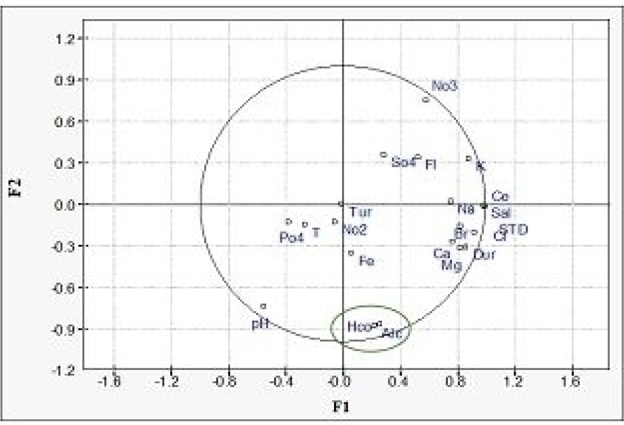 Legend: Ca - Calcium; Mg - Magnesium; Na - Sodium; K - Potassium, HCO - Bicarbonate; SO4 - Sulfate, PO4 - Phosphate; STD - Total dissolved solids; Fl - Flouride; Ce - Eletrical conductivity; Fe - Iron; Br - Bromide; NO2 - Nitrtite; NO3 - Nitrate; Alc - Alkalinity; Sal - Salinity; Cl - Chloride; Tur - Turbidity.
 Legend: Ca - Calcium; Mg - Magnesium; Na - Sodium; K - Potassium, HCO - Bicarbonate; SO4 - Sulfate, PO4 - Phosphate; STD - Total dissolved solids; Fl - Flouride; Ce - Eletrical conductivity; Fe - Iron; Br - Bromide; NO2 - Nitrtite; NO3 - Nitrate; Alc - Alkalinity; Sal - Salinity; Cl - Chloride; Tur - Turbidity.