 Assessment of Surface Radiogenic Heat Flow in Volcanic Rocks of Trindade Island, South Atlantic Ocean, Brazil
Abstract
Heat loss from Earth’s interior, driven by conduction and convection, influences lithospheric thermal regimes. This heat originates from mantle convection, primordial planetary accretion, and the decay of radioactive heat-producing elements (RHPE: U-238, U-235, Th-232 and K-40), which contribute around 98% of Earth’s radiogenic heat production, crucial for surface radioactive heat flux (SRHF). Understanding RHPE is key to studying geothermal dynamics, especially in volcanic regions like Trindade Island, Brazil. This study aims to: Quantify U, Th, and K concentrations in volcanic soils; map their spatial distribution, detect anomalies and evaluate radiogenic heat production and flux. Three methods were used: whole-rock ICP analyses for geochemical characterization, laboratory gamma spectrometry (LabGRS), and in situ gamma spectrometry (surfGRS) for spatial coverage. A total of 77 samples and 481 measurement points were analyzed and SRHF was measured. Results show that the thorium contributes most to SRHF, providing insights into heat generation and mantle-crust volcanic interactions. This study provides critical insights into radiogenic heat generation and its role in lithospheric thermal evolution, offering a refined understanding of heat production in oceanic volcanic settings. The findings enhance geophysical and geochemical models of heat flux, contributing to broader studies on mantle-crust interactions and geothermal energy potential.
Key words
Radiogenic Heat Production; Radiogenic Heat Flow; South Atlantic Ocean; Trindade Island; Volcanic rocks
INTRODUCTION
Heat loss by conduction from Earth’s interior controls lithospheric thermal regimes, which reflect both heat from mantle convection currents and heat generated by radioactive decay, which is supplied by the primordial heat accumulated during early planetary accretion, subsequent segregation and crystallization from the terrestrial mantle-core and by the radioactive decay of their radioactive heat producing elements (RHPE) (Pollack et al. 1993). Present-day Earth’s global surface radioactive heat flow (SRHF) is due to RHPE, which has disintegration half-lives similar to the age of the Earth, even contributing to the overall heat flow from the Earth’s interior (McDonough 2021), namely the radioactive decay series of U-238 (half-life ≈ 4.5 Ga), Th-232 (half-life ≈ 14 Ga) and K-40 (half-life ≈ 1.3 Ga). These three radioisotopes are responsible for 98% of current terrestrial heat production. However, U-235 (half-life ≈ 0.7 Ga) is another Uranium isotope that also contributes to the production of the Earth’s heat, but due to its shorter half-life, its residual mass is less than 0.7 % of total Uranium existing on Earth (Schaefer 2016, Chauvel 2020, Liu et al. 2016, Zhang et al. 2018, 2020 Jiang et al. 2019, McDonough 2021, White 2023). The contribution of long-lived radioactive isotopes such as Rb-87 (half-life ≈ 49 Ga) and Sm-147 (half-life ≈ 106 Ga) are hardly noticeable to Earth’s global heat, due to their radioactive decay rates being greater than Earth’s age (Chauvel 2020, McDonough 2021). However, in the early formation of Earth, there were radioactive isotopes with a short half-life (e.g.: Al-26; Fe-60; Nb-92) with significant radioactive heat contribution, but undetectable in the present (Schaefer 2016, Chauvel 2020, White 2023). Mid-oceanic ridges during the formation of the oceanic lithosphere play a significant role in the global oceanic heat flow, dissipating it by convection and magmatic solidification. This heat loss from the oceanic ridge is on the order of 45% of the Earth’s total heat flow (German 2013, Qiuming 2016, Liu et al. 2016, Zhang et al. 2018, 2020 Jiang et al. 2019, Harris et al. 2020, Poort et al. 2020, Graw et al. 2023, Olive 2023, Terra-nova et al. 2023). In turn, heat loss across continents is estimated to range from 30 to 55% (Jaupart & Mareschal 2007, Jaupart et al. 2016, Artemieva et al. 2017, Balkan-Pazvantoğlu & Erkan 2019, Pollett et al. 2019, Veikkolainen & Kukkonen 2019, Akingboye et al. 2021, 2022, Adewumi et al. 2023, Liao et al. 2023).
Most oceanic volcanic islands are associated with hotspot activities (Koppers et al. 2021). These are fed by a deep region in the Earth’s mantle, from which heat rises via convection currents. This heat facilitates the rock fusion at the base of the lithosphere, where the upper and brittle part of the mantle meets the Earth’s crust, generating magmas, which most often go beyond the surface of the oceanic and continental crusts, through fractures, generating volcanoes (Koppers et al. 2021).
The objectives of the present study are: (i) identify the total levels of U, Th and K in soils on the volcanic island of Trindade, South Atlantic Ocean, Brazil; (ii) reveal the main spatial distribution of element concentrations and sources that determine their spatial distribution; (iii) analyze data that take into account their compositional nature; (iv) define potential spatial anomalies based on the complex relationships between lithogeochemical properties and elemental occurrence; v) evaluate the production and flux of radiogenic heat associated with radioactive elements.
HISTORICAL AND GEOLOGICAL CONTEXTS
Historical context
Trindade Island is located 1,140 km from the Brazilian coast, located at 20°28’28” S and 28°51”05’ W and circa 48 km to the west of the Martin Vaz Archipelago (Figure 1). This volcanic island is an important Brazilian geological landmark, as it preserves the youngest sub-saturated alkaline volcanic activity of Plio-Pleistocene age and shows different pyroclastic structures. This island crops out the only preserved volcanic cone in Brazil: The Paredão volcano (Almeida 1961, Cordani 1970).

The discovery of Trindade Island and the Martin Vaz Archipelago (Figure 1) took place in 1501 and is attributed to João da Nova, a Galician navigator, who was at the service of the Portuguese Crown during the Great Navigations (16th century) and having named it “Ilha da Assumpção”. However, the discovery of Trindade Island is still controversial. Most historians support the hypothesis that the Portuguese navigator Estevão da Gama, during Vasco da Gama’s second voyage to the Indies, would have discovered the island of Trindade. This Portuguese navigator named it “Ilha da Trindade”, in honor of the Holy Trinity, because at a great distance on the high seas it is possible to see the three highest elevations on the island. The name of Trindade Island appears first on the nautical chart of the Italian Vesconte di Maggiolo, dated ca. 1504. However, due to the difficulties in calculating longitude at that time, in the map of Kunstmann III, dated ca. 1507, the location of Trindade Island appears in two positions and under the names “Acensam” and “At’nitade” and Martin Vaz Island appears on this chart in three positions as “Martinvas”, “V”, “Queschon” and “Santa Maria d’Agosto” (Alves & Silva 2016). D. João III, the King of Portugal, in 1538, donated the Trindade Island to the Portuguese nobleman Belchior Camanho, but he never officially occupied it (Alves & Silva 2016). Circa 1700, Captain Edmond Halley, the famous English astronomer and mathematician, claimed this island as a British possession on behalf of King William III of England, Scotland and Ireland, and was part of the first expedition to land on Trindade Island during his navigation. Sir Edmond Halley unintentionally, generated the first Brazilian ecological disaster, because when leaving the island, he landed goats and pigs, to serve as food for navigators or shipwrecked people who landed on the island, a common practice at the time. In the three hundred years of feral life, this goat herd has become a big ecological problem, as they have devastated a good part of the native flora and contributed to erosion in various parts of the island. The situation is so serious that in some areas the soil has already been completely leached by the rains, forming huge rifts, furrowing and causing a certain impact on the island’s landscape. This fact occurred in several oceanic islands around the world. Some classic examples are Bali, Moorea, Maui and some islands of the Galapagos Archipelago (Gasparini & Floeter 2001). The last goat was killed by the Brazilian Navy in the mid-20th century (SECIRM 2017). There is still much to be told about the history of Trindade Island, but it is beyond the scope of our research.
Geological context
Trindade Island belongs to a volcanic lineament named Vitória-Trindade Ridge (VTR), composed of over 30 seamounts and is the farthest Brazilian island in the South Atlantic from the mainland (Figure 1-3. Its geology shows an important and preserved Brazilian Plio-Pleistocene sub-saturated alkaline volcanic and pyroclastic structures (Almeida 1961).
According to Almeida (1961), Trindade Island is constituted of ultrabasic to intermediate alkaline volcanic rocks (Figures 2, 3), generated by five volcanic successive events. He defined the geological sequence of Trindade Island, which consist, from oldest to youngest as: 1) Trindade Formation, widely distributed on the island, display pyroclastic deposits and subvolcanic bodies (e.g.: domes, dikes and plugs); 2) Desejado Formation, an outcrop in the central part of the island, showing phonolitic spills, phonolitic-tephrite, and nephelinite, intercalated with pyroclastic rocks; 3) Morro Vermelho Formation, which shows nephelinitic flows of basanite and tephrite; 4) Valado Formation, the smallest volcanic event on the island, formed by intermediate undersaturated alkaline spills (tephri-phonolite, phonolitic-tephrite) and 5) Paredão Volcano Formation, which appears in the form of a volcanic cone, characterized by the abundant pyroclastic deposits and melanephelinite spills and is the youngest volcanic rocks on Trindade Island (Figures 2, 3).

Geologic map of Trindade Island, South Atlantic Ocean, Brazil. Color for Geologic Maps according to the United States Geological Survey (https://mrdata.usgs.gov/catalog/lithclass-color.php).

Images of the Trindade Island: a) Overview of the island; b) Trindade Formation, Desejado peak (620 m), St. Boniface peak (570 m) and Trindade peak (590 m); c) Monument peak (270 m), phonolite neck; d) Sugar Loaf peak (392 m), phonolite neck, close to the Paredão volcano; e) Paredão volcano (217 m) and its volcanic semi-cone; f) Overview of the Western slope of the Paredão volcano and the Sugar Loaf peak. Photography by Lucas Knupp.
A stratigraphic revision of the island defined by Almeida (1961) was made by Pires & Bongiolo (2016) based on new fieldwork and petrography data and were the first to define the eruptive styles of all five formations. Pasqualon et al. (2019) defined a new model for Paredão Volcano Formation volcanism, through a detailed stratigraphic framework involving the identification, description, and interpretation of lithofacies. Figueiredo et al. (2022) took into account the quantitative morphological analyses of the shapes of juvenile pyroclasts, in order to interpret their fragmentation mechanisms according to the dry or wet nature of the magma, thus defining the eruption style on Trindade Island.
MATERIALS AND METHODS
We collected 77 volcanic rock samples and measured Gamma Ray Spectrometry on sample points and also other areas (n: 481) of Trindade Island (Figure 4). These rock samples are representative of all volcanic lithologies present on the island, and Cordani (1970) sample analyses and location were used as references (Figure 4). These rocks were sampled in a random distribution, 10 to 20 cm below the surface, to reduce the effects of meteoric alteration. For Gamma Ray Spectrometry, we used two different instruments, the first instrument for laboratory analyses (labGRS) was the High-purity Germanium detector (HPGe) model GC-3020 by Canberra (747 shield model, chamber of 252 cm3 and 10 cm of low-background lead, inner surface coated with 1 mm tin liner and 1.6 mm copper liner, shield exterior coated with 9.5 mm of steel with low carbon percent). The count time (live time) used to obtain the background and a sample activity spectrum was 8 hours. The multichannel system used was DSA 1000 (Digital Spectrum Analyzer), with 8192 channels, with energy range from 50 KeV to 2 MeV. Energy calibration was performed with the aid of the Gamma Analysis software from Genie 2K, using certified radioactive sources, totaling five experimental points which corresponded to the 137Cs (0.6617 MeV), 60Co (1.17 and 1.33 MeV) and 152Eu (0.1218 and 0.3443 MeV) peaks, where 77 rock samples were measured. The second instrument for field work (surfGRS) was the Gamma ray spectrometer model RS-230 Super-spec (BgO detector of 103 cm3) from Radiation Solution, where 481 points were measured, about 80 cm above the rocky surface, with a sampling time of 360 s, following the recommended methodologies of the International Atomic Energy Agency (IAEA 2003) for low radioactivity outcrops. Bulk rock chemical analyses were done at ALS-CHEMEX Laboratory (Vancouver, Canada) and trace element concentrations by ICP-AES (Varian/Vista) and ICP-MS (Perkin-Elmer/ELAN-800. The bulk rock specific densities were measured by QUANTACHROME ULTRAPYC 1200E with 10 cm3 cells (Accuracy: < ± 0.03% g/cm3; Repeatability < ± 0.015% g/cm3).

Land’s slope and all rock sample and GRS measured points on Trindade Island, South Atlantic, Brazil. Black triangle: all rock sampling and GRS measured points. Blue star: Cordani’s reference samples (Cordani 1970).
We were not able to measure the entire island due to rugged terrain and frequent landslides that damaged certain trails, such as the trail to Pico do Monumento, inaccessible during the fieldwork. As a result, measurements along this route were not possible, potentially limiting the spatial coverage. Additionally, steep slopes (Figure 4) and unstable ground conditions restricted access to some volcanic rock exposures, further constraining the sampling effort. Despite these limitations, the data collected from accessible sites provide valuable insights into the radiogenic elements of Trindade Island. Future studies could address these gaps by expanding sampling efforts to include areas that are currently inaccessible.
To ensure the accuracy of our measurements, we accounted for the gamma radiation background by removing it. Trindade Island is geographically isolated, with the nearest island situated 47 km to the east (Figure 1). To eliminate the influence of cosmic radiation, the gamma radiation background was measured from an inflatable boat approximately 8 km away from the island. A total of 56 readings were taken around the island, yielding an average background value of 30 nGy/h. This average was then subtracted from all gamma radiation measurements conducted on the island (Arnold et al. 2019).
From the collected samples, surface heat-production elements (SHPE) values were obtained through whole-rock chemical analyses and laboratory Gamma Ray Spectrometry (labGRS) of 77 volcanic rock samples from Cordani (1970). The dose rate in nGy/h was calculated using the relationship established by Beck et al. (1972) (Table I).
Statistical synthesis of SHPE and density of volcanic rock (n: 77) from Trindade Island, South Atlantic Ocean, Brazil: A) by whole-rock chemical analyses (ICP) and density; B) by laboratory Gamma Ray Spectrometry (labGRS) and density.
Figure 5 shows the petrological classification of volcanic rocks from Trindade Island, South Atlantic Ocean, Brazil, based on the major elements compositions, R1 x R2 diagram (De la Roche et al. 1980) and Total Alkalis x SiO2 (Le Bas et al. 1986).

a) R1 versus R2 {(4Si-11(Na+K)-2(Fe+Ti)) vs (6Ca+2Mg+Al)} diagram of volcanic rocks from Trindade Island, South Atlantic Ocean, Brazil. Based De la Roche et al. (1980); b) Total Alkalis versus SiO2 diagram of volcanic rocks from Trindade Island, South Atlantic Ocean, Brazil. Based Le Bas et al. (1986).
RESULTS
Comparison among whole-rock inductively coupled plasma (ICP) analyses and laboratory Gamma Ray Spectrometry (labGRS)
The comparison of ICP whole-rock analyses and labGRS results are presented in Table II and plotted in Figures 6 and 7. All rocks show a good linear correlation between the radionuclides measured with intercept close to zero, except the K in intermediate rocks, which show labGRS data higher than ICP values (Figure 6). The Uranium and Thorium content and the Th/U ratio is highly variable but lower than crustal average 3.9 (Palme & O’Neill 2014), being the Thorium and Uranium contents responsible for more than 50% of the surfGRS on Trindade Island, with the Gamma radiation from Thorium predominating over the other two isotopes analyzed (Figure 7).
Linear regression coefficients of ICP versus labGRS analyses of U, Th and K given in Table I of volcanic rocks from Trindade Island, South Atlantic Ocean, Brazil.
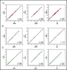
Comparison among ICP and GRS analyzes of Uranium, Thorium and Potassium contents of volcanic rocks from Trindade Island, South Atlantic Ocean Brazil: a) Intermediate rocks; b) Basic rocks; c) Ultrabasic rocks. Eq.a.: Equivalent activity.

Ternary diagram of Uranium x Thorium x Potassium of volcanic rocks from Trindade Island, South Atlantic Ocean, Brazil: a) whole rocks ICP analyses; b) surfGRS.
Mapping Surface Radioactive Heat Producing Elements (SRHPE) by Whole-Rock ICP Analyses and Surface Gamma Ray Spectrometry (surfGRS)
Surface radioactive heat producing elements (SRHPE) (Table III) were measured using two complementary methods: whole-rock inductively coupled plasma (ICP) analyses and surface gamma ray spectrometry (surfGRS). Whole-rock ICP analyses provided precise and quantitative measures of the U, Th, and K concentration at selected sample locations around the island offering high accuracy for geochemical characterization. Alternatively, surfGRS allows extensive coverage of measurements, making it an optimal choice for regional mapping. Both measures methodologies were interpolated by Natural neighbor method, creating a continuous raster surface to represent the spatial distribution of these elements minimizing the artifacts that could be generated by it. There were 77 samples collected to be used on whole-rock ICP analyses and 481 points measured by surfGRS both provided U (ppm), Th (ppm), K (%) and radioactive absorbed dose (nGy/h). After the compilation of data, a statistical analysis was done and a histogram generated with the maps for whole-rock ICP (Figures 8-11) and surfGRS (Figures 12-15) providing insights of radiometric characteristics of Trindade Island.
Statistical synthesis of SHPE, mean density, Asurf and Qsurf of all volcanic rock (n: 558) from Trindade Island, South Atlantic Ocean, Brazil, by Surface Gamma Ray Spectrometry.
Surface Radiogenic Heat Production
The surface radiogenic heat production (SRHP) of a given rock sample, hereafter referred to as Asurf, was estimated using the empirical equation (1) defined by Rybach (1976, 1988) and Rybach & Čermák (1982):
Where Asurf is surface radiogenic heat production (SRHP) of the rock in µW/m3, is rock density (kg/m3) and C U and C Th in ppm and C K in % and these are the heat-producing elements contents.
The Asurf rates for such units are comparable, despite the discrepancy in some samples, where we have lower levels of whole-rock ICP than the equivalent activity labGRS levels (Figure 6).
We also calculated the Asurf for both HPE obtained by whole-rocks ICP analyses, as well as labGRS. The average Asurf results are summarized in Table IV and illustrated as a natural neighbor surface color map and histogram of the radiogenic heat production in Figure 16.
Statistical synthesis of SRHP (Asurf, µW/m3) and the respective contribution of radioisotope results of volcanic rocks from Trindade Island, South Atlantic Ocean, Brazil: A) whole rocks ICP analyses; B) labGRS.

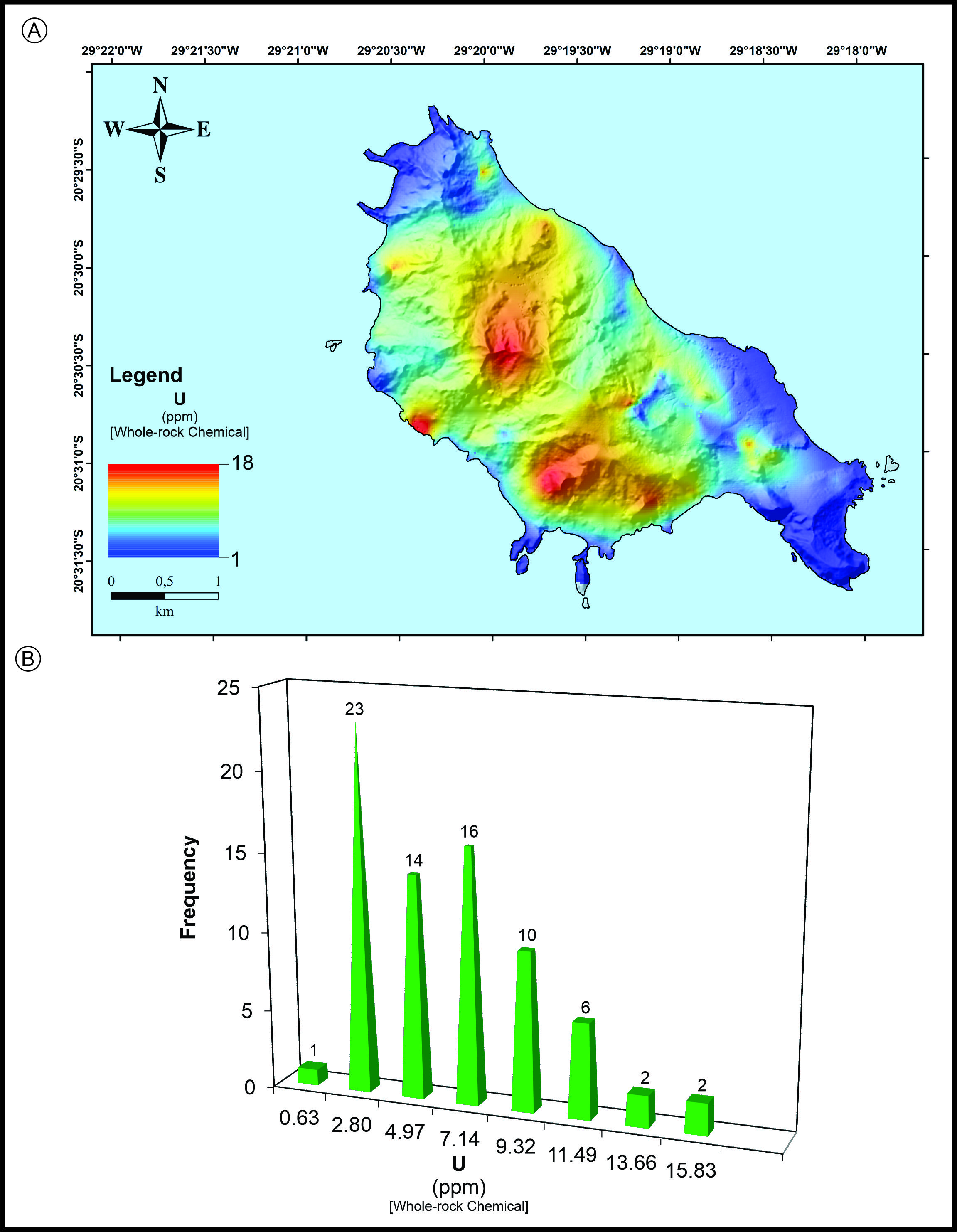
Natural neighbor surface color map (a) and histogram (b) of SRHPE Uranium (ppm) by whole-rock ICP of volcanic rocks from Trindade Island, South Atlantic Ocean, Brazil.

Natural neighbor surface color map (a) and histogram (b) of SRHPE Thorium (ppm) by whole-rock ICP of volcanic rocks from Trindade Island, South Atlantic Ocean, Brazil.

Natural neighbor surface color map (a) and histogram (b) of SRHPE Potassium (%) by whole-rock ICP of rocks from Trindade Island, South Atlantic Ocean, Brazil.

Natural neighbor surface color map (a) and histogram (b) SRHPE radioactive absorbed dose (nGy/h) by GRS of volcanic rocks from Trindade Island, South Atlantic Ocean, Brazil.

Natural neighbor surface color map (a) and histogram (b) of SRHPE Uranium (Eq.a. ppm) by GRS of volcanic rocks from Trindade Island, South Atlantic Ocean, Brazil. Eq.a.: Equivalent activity.

Natural neighbor surface color map (a) and histogram (b) of SRHPE Thorium (Eq.a. ppm) by GRS of volcanic rocks from Trindade Island, South Atlantic Ocean, Brazil. Eq.a.: Equivalent activity.

Natural neighbor surface color map (a) and histogram (b) of SRHPE Potassium (%) by GRS of volcanic rocks from Trindade Island, South Atlantic Ocean, Brazil.

Natural neighbor surface color map (a) and histogram (b) of SRHPE Potassium (%) by GRS of volcanic rocks from Trindade Island, South Atlantic Ocean, Brazil.
Surface Radiogenic Heat Flow
It is accepted that the surface radiogenic heat flux (SRHF, denoted Qsurf) in a given area shows a linear correlation with SRHP (denoted Asurf) as expressed by the empirical equation (2) defined by Birch et al. (1968) and written as follows:
Where Qred is the reduced heat flow (mW/m2), Asurf is the SRHP based on the SRHPE data (µW/m3) and D is the thickness of the upper crust (HG) layer. The reduced heat flow (Qred) represents the portion of surface heat flow that originates from the mantle, which serves as baseline level in absence of radiogenic contribution from the upper crust. In the linear relationship defined by equation (2), Qred corresponds to the intercept when Asurf = 0 and the product of Asurf x D represents the additional surface heat flow generated by radioactive decay within the upper crustal layer of thickness D. The relationship between Qsurf x Asurf express how the total surface heat flow is partitioned between the basal heat flow (Qred), which is, the average heat flow at depth D of the crust (upper mantle or Moho), and the radiogenic heat flow produced within the upper crust. As a result, the basal heat flow (Qred) represents an increasing fraction of the total surface heat flux (SRHF) as depth increases.
We calculated the SRHF (Qsurf) for both SRHPE obtained by whole-rock ICP analyses, as well as GRS. The average Qsurf results are summarized in Table V and illustrated as a Natural neighbor surface color map and histogram of the surface radiogenic heat flow in Figure 17.
Statistical synthesis of SRHF (Qsurf, mW/m2) results of volcanic rocks from Trindade Island, South Atlantic Ocean, Brazil: A) SRHF by whole-rock ICP analyses; B) SRHF by GRS. SRHF: Surface radiogenic heat flow; HF : Heat flow; Max: Maximum; Min: Minimum; Med: Median; GM: Geometric Mean; SD: Standard Deviation.

Comparison among Asurf (µW/m3) and Qsurf (mW/m2) of all volcanic rocks from Trindade Island, South Atlantic Ocean Brazil: a) by Whole-rock ICP analyses; b) by GRS.
DISCUSSION
The surface radiogenic heat production (SRHP) of rocks from Trindade Island show inhomogeneous distribution (Table IV and Figure 16), probably this was caused by overlapped complex volcanic activity (e.g.: different volcanic episode type; different age rocks) and the secular radioactive disequilibrium due to some hydrothermal and/or weathering process. It should be noted that the phonolite rocks show higher Potassium values and the ultrabasic rocks lower values. However, Uranium and Thorium show a similar distribution.
To understand the origin of the surface heat source in Trindade Island, South Atlantic Ocean, Brazil, we consider the Sclater-Francheteau model for the oceanic lithosphere and the reduced heat flow (Qred) of the lithosphere layers (Figure 18) defined by the authors (Sclater & Francheteau 1970, Sclater et al. 1980). This model provides for a 120 km thick lithosphere plate, constituted as follows: 5 km of a basalt layer with RHP of 5 µW/m3 + 15 km of lherzolite layer with a RHP of 1.3 µW/m3 (D layer) and a 100 km of “Pyrolite I” layer (a mixture of one part basalt with three parts ultramafic peridotite (70)) with a RHP of 1.3 µW/m3.

Natural neighbor surface color map and histogram SRHF (Qsurf) by whole-rock ICP analyses and GRS of volcanic rocks from Trindade Island, South Atlantic Ocean, Brazil: a) Natural neighbor surface color map and b) Histogram of SRHF (QSurf) by ICP analyses; c) Natural neighbor surface color map and d) Histogram of SRHF (Qsurf) by GRS.
The RHP of this model generates a RHF on the surface of 4.6 mW/m2, thus distributed about 1.7 mW/m2 comes from the lithosphere and 2.9 mW/m2 from the Mantle (Pyrolite I) and Pyrolite II, whose average RHP is 4.2 µW/m3, with a RHF of 16.8 mW/m2, at a depth of 400 km (Sclater & Francheteau 1970, Sclater et al. 1980). However, there is no general model of radioactive heat generation for the lithosphere because it is impossible to characterize all the geographic regions of the continents and ocean (Rybach 1976, Rybach & Cërmák 1982, Hasterok & Webb 2017, Hasterok et al. 2018, Clauser 2021).
For the Qsurf calculations (Equation 2) we assumed that the contents of the SHPE are normally distributed and the reduced heat flow (Qred) from the lithospheric layer is 4.6 x 10⁻⁵ mW/m2 and for the D, we consider the thickness of 25 km (5 km of basalt layer + 15 km of lherzolite layer and more 5.6 km from Trindade Island outcrop, reference therein (Figure 18), consequently the thickness of D layer is similar to the scale of horizontal fluctuation in radioactivity, the effect of lateral heat production variation on Qsurf is negligible, because there are no lateral contribution from the heat production by other rocks (Table V and Figure 1).
The surface radioactive heat production (SRHP) in a given area is controlled by the surface heat production element distribution (SHPE). The Uranium, Thorium and Potassium levels in the volcanic rocks from Trindade Island were measured by both whole-rock ICP analyses and by laboratory Gamma radiation spectrometry (labGRS) (Tables I, IV and V). Given the location of the studied samples (Figure 2), they are representative of the surface or apparent values. However, the SHPE and SRHP (Asurf) calculated by the two methods within the same geological unit are proportionally similar (Table II and III; Figure 6), despite the discrepancy in some samples, where we have lower levels of SHPE by whole-rock ICP analyses than the equivalent activity labGRS levels. The area possesses a range of SRHP ranging 0.46 and 6.73 μW/m3 (Geometric mean: 2.66 μW/m3) by whole-rock ICP analyses and between 0.59 and 6.85 μW/m3 (Geometric mean: 2.82 μW/m3) by laboratory Gamma ray spectrometry and there is a good correlation between these techniques (Table II and IV; Figure 6).
The surface radioactive heat production may exhibit some irregularity due to the dissimilarity in the geochemical behavior of U, Th and K during geological processes which determine the SHPE distribution. It is plausible that the inhomogeneous distribution of Asurf was caused by overlapped complex differentiation processes (e.g.: different volcanic episode type, different age rocks and the secular radioactive disequilibrium induced by hydrothermal fluids and/or weathering).
The calculated average of the SRHP of volcanic rocks (2.74 µW/m3) from Trindade Island are higher (Table IV) than the average SRHP of crustal rocks and lithospheric mantle published by (Jaupart & Mareschal 2007) 0.018 µW/m3, (Hasterok et al. 2018) 0.02 µW/m3, (Rybach 1976) 0.099 µW/m3, (Rybach & Čermák 1982) 0.013 µW/m3 and (Rudnick et al. 1998) 0.024 µW/m3. This is because the volcanic rocks from Trindade Island suffered metasomatism that affected surface exposures during exhumation and/or near-surface groundwater flow that increased SRHPE levels, as suggested by (Russell et al. 2001) for the Jericho xenoliths on the Slave craton.
The SRHF (Qsurf) mimic the SRHP (Asurf) within all volcanic rocks from Trindade Island and varying from 13.9 to 139.1 with Median of 69.2 mW/m2, Geometric mean of 58.92 mW/m2 and Standard deviation: 31.69 by whole-rock ICP (Table VIa) and from 7.1 to 341.46 mW/m2 with Median of 47.41 mW/m2, Geometric mean of 61.98 mW/m2 and Standard deviation: 31.83 by labGRS (Table VIb; Figure 19)
Statistical synthesis of SRHP (Asurf, µW/m3) and SRHF (Qsurf, mW/m2) average results of all volcanic rocks from Trindade Island, South Atlantic Ocean, Brazil: A) SRHP by whole-rock ICP analyse (77) and by labGRS (481); B) SRHF by whole-rock ICP analyse (77) and by labGRS (481). Surf: surface; Max: Maximum; Min: Minimum; Med: Median; GM: Geometric mean; SD: Standard deviation.

Natural neighbor surface color map and histogram of SRHP (ASurf) of volcanic rocks from Trindade Island, South Atlantic Ocean Brazil: a) Natural neighbor and b) Histogram of SRHP (ASurf) by whole rocks ICP analyses; c) Natural neighbor and d) Histogram of SRHP (ASurf) by labGRS.
Although the average SRHP of the volcanic rocks from Trindade Island is high, their respective all rock median SRHF is relatively lower (58.31 mW/m2) when compared with suggested average oceanic heat flow, which ranges from 80 to 101 mW/m2 (Palme & O’Neill 2014, Pasquale et al. 2014) and stable continental margin, which show an average of 80 mW/m2, but is similar to the SRHF from the Earth’s (60 mW/m2 on 12 grid of the Earth’s surface), also similar to the mean SRHF of Brazil (59 mW/m2) (http://heatflow.world/project, accessed: 2023/02/24, Fuchs et al. 2023) and slightly higher than that of the average SRHF of 55 mW/m2 from Late Cretaceous-Early Tertiary alkaline intrusion of Poços de Caldas (Minas Gerais state, Brazil) (Vitorello et al. 1980). This is also in agreement with Jessop (1990) who stated that it is probably the largest source of heat in the Earth’s crust and other sources may be important in specific locations. Therefore, we can suggest that the most likely source of radioactive heat flow on the Trindade Island area appears to be associated only with heat flow from the upper mantle.
Trindade Island shows a SRHPE relatively higher than those predicted for volcanic rocks, the SRHF from radioactive disintegration is also relatively lower than those predicted for the oceanic crust or stable continental margins (Turcotte & Oxburgh 1967, McKenzie 1967, Sclater et al. 1980). This suggests that the RHF from the upper mantle in the Trindade Island area is relatively low compared to the RHF from upper mantle of other areas in the oceanic crust, like that found in the São Pedro and São Paulo archipelago, Equatorial Atlantic by Campos et al. (2022). The continental heat flow is due to the higher crustal radiogenic heat production element, while oceanic heat flow is due to the transport of heat to the Earth’s surface by mantle convection (Turcotte & Oxburgh 1967, McKenzie 1967, Sclater et al. 1980, Koppers et al. 2021).
On Trindade Island, South Atlantic Ocean, Brazil, for all the volcanic rocks, the SRHF (Qsurf) mimetic the SRHP (Asurf) whether they are calculated either by whole-rock ICP analyses or by Gamma ray spectrometry. Our research demonstrated that the results obtained by these techniques have a good correlation (Table II; Figures 6 and 19) and that their results are similar, by the equations Qsurf = 21.185 x Asurf (R2 = 0.9957) and Qsurf = 20.844 x Asurf (R2 = 0.9968), respectively whole-rock chemical and GRS analyses (Figure 19), with those obtained by GRS being slightly higher than those obtained by whole-rock ICP analyses.
CONCLUSIONS
Based on this study, we draw the following conclusions:
-
The ultrabasic volcanic rocks from Trindade Island show low Surface Radioactive Heat Producing values in the range of 0.5 to 4.0 μW/m3 (Med: 1.5; GM: 1.35 μW/m3. SD: 0.89), whereas the highest values are found in intermediate volcanic rocks that range between 2.2 to 6.9 μW/m3 (Med: 3.9; GM: 3.9 μW/m3);
-
In general, we associate “radiometric anomalies” with volcanic manifestations of a phonolytic nature;
-
The surface radiogenic heat producing elements shows great variation both by whole-rock ICP analyses [U (Max: 48.0, Min: 0.6, GM: 3.1, SD: 3.0), Th (Max: 9.9, Min: 2.3, GM: 10.5, SD: 12.0, K (Max: 7.1, Min: 0.2, GM: 2.8, SD: 2.1)] and by Gamma ray spectrometry [U (Max: 32.3, Min: 0.2, GM: 3.6, SD: 5.4), Th (Max: 103.9, Min: 0.6, GM: 12.5, SD: 17.50, K (Max: 9.2, Min: 0.1, GM: 1.8, SD: 2.5)];
-
There is no correlation between the Uranium and Thorium content and the Th/U ratio is highly variable but lower than crustal average (3.9), but these radioisotopes are responsible for circa 75% of surface radiogenic heat producing elements;
-
The surface radiogenic heat production ranging 0.46 and 6.73 μW/m3 (Med: 3.23; GM: 2.66, SD: 1.58) by whole-rock ICP analyses and between 0.13 and 16.84 μW/m3 (Med: 2.14; GM: 2.15, SD: 2.77) by Gamma ray spectrometry, these techniques show a good correlation between them;
-
The surface radiogenic heat flow on the Trindade Island shows an average of 58.3 mW/m2, this SRHF mean calculated between whole-rock ICP analyses and gamma ray spectrometry data is similar to the SRHF from the Earth’s (60 mW/m2, on 12 grid of the Earth’s surface), also similar to SRHF mean of Brazil and slightly bigger of than that of the average SRHF of 55 mW/m2 from Late Cretaceous-Early Tertiary alkaline intrusion of Poços de Caldas region (Minas Gerais state, Brazil);
-
Therefore, we can suggest that the most likely source of radioactive heat flow on the Trindade Island area appears to be associated with heat flow from the upper mantle alone;
-
Future studies should expand sampling efforts to include inaccessible areas of Trindade Island, such as Pico do Monumento trail, to improve the spatial coverage radiogenic heat production measurements.
Acknowledgements
This paper was significantly improved by review from Dr. Léo Afraneo Hartmann (Federal University of Rio Grande do Sul, Geology Department, Brazil). We would like to thank Dr. Alcides Pereira (Geosciences Institute of Coimbra University, Portugal) for providing laboratory support to GRS analyses. This research was carried out in the Scientific research program on oceanic islands (Pro-Ilhas) of Inter Ministerial Secretariat Commission for Marine Resources (SECIRM, Brazilian Government) and a grant from Conselho Nacional de Desenvolvimento Científico e Tecnológico (CNPq) and Petroleum of Brazil (PETROBRAS/CENPES). We would like to thank the CNPq (ProTrindade Program Process No. 557,146/2009–7 and Process No 441837/2024-7) and CNPq PQ 2021 (Process No 304837/2021-0), and Fundação de Amparo à Pesquisa do Estado do Rio de Janeiro (FAPERJ) [Entidades Estaduais 2018 n° 210.297/2018; APQ1 2019 n° 210.179/2019; JCNE 2022 n° 201.469/2022]. We would also thank the research groups as GeoBioTec (Aveiro University, Portugal), Dom Luiz Institute (Lisboa University, Portugal), Tektos Group, and GeoAtlantic Institute (Rio de Janeiro State University, Brazil INCT CNPQ Process No 405653/2022-0). and funds from Fundação para a Ciência e a Tecnologia, I.P. (Portugal) in the frame of UIDB/00073/2025 and the UIDP/00073/2025 projects of the I & D unit of Geosciences Center (University of Coimbra, Portugal).
References
-
ADEWUMI T ET AL. 2023. Reconstruction of the subsurface crustal and radiogenic heat models of the Bornu Basin, Nigeria, from multi-geophysical datasets: Implications for hydrocarbon prospecting. Adv Space Res 71: 4072-4090. https://doi.org/10.1016/j.asr.2023.01.007.
» https://doi.org/10.1016/j.asr.2023.01.007 - AKINGBOYE AS ET AL. 2021. Radioactivity, radiogenic heat production and environmental radiation risk of the Basement Complex rocks of Akungba-Akoko, southwestern Nigeria: insights from in situ Gamma-ray spectrometry. Environ Earth Sci 80: 228.
-
AKINGBOYE AS ET AL. 2022. Radiogeochemistry, uranium migration, and radiogenic heat of the granite gneisses in parts of the southwestern Basement Complex of Nigeria. J Afr Earth Sci 188: 104469. https://doi.org/10.1007/s12665-021-09516-7.
» https://doi.org/10.1007/s12665-021-09516-7 - ALMEIDA FFM. 1961. Geologia e petrologia da Ilha Trindade. DNPM, Divisão de Geologia e Mineralogia, Monografia 18: 197.
- ALVES RJV & SILVA NGS. 2016. De Historia Naturali Insulæ Trinitatis MDCC – MMX. Três Séculos de História Natural na Ilha da Trindade com Comentários Sobre Sua Conservação. Smashwords, ISBN: 9781370853601.
- ARNOLD D, HECKEL A & WERSHOFEN H. 2019. Procedures Manual for monitoring of radioactive substances in the environment and of external radiation (Messanleitungen für die “Überwachung radioaktiver Stoffe in der Umwelt und externer Strahlung”). Version June 2019, ISSN 1865-8725.
- ARTEMIEVA IM, THYBOB H, JAKOBSENA K, SØRENSENA NK & NIELSENA LSK. 2017. Heat production in granitic rocks: Global analysis based on a new data compilation GRANITE2017. Earth-Sci Rev 172: 1-26.
-
BALKAN-PAZVANTOĞLU E & ERKAN K. 2019. Temperature-depth curves and heat flow in central part of Anatolia, Turkey. Tectonophysics 757: 24-34. https://doi.org/10.1016/j.tecto.2019.02.019.
» https://doi.org/10.1016/j.tecto.2019.02.019 -
BECK HL, DECAMPO JA & GOGOLAK CV. 1972. In-Situ Ge(Li) and NaI(Tl) Gamma-ray Spectroscopy. Report HASL-258, US Atomic Energy Commission, New York. https://doi.org/10.2172/4599415
» https://doi.org/10.2172/4599415 - BIRCH F, ROY RF & DECKER ER. 1968. Heat flow and thermal history in New England and New York. In: Zen E et al. (Eds), Studies of Appalachian Geology: Northern and Maritime. Interscience, New York, p. 437-451.
- CAMPOS ET AL. 2023. Mapping of surface radiogenic heat production from laboratory Gamma spectrometry and chemical data of exhumed mantle peridotites at the St. Peter and St. Paul Archipelago (Equatorial Atlantic). Appl Radiat Isot 192: 110608.
-
CHAUVEL C. 2020. Long-Lived Radionuclides. Reference Module in Earth Systems and Environmental Sciences, Elsevier. https://doi.org/10.1016/B978-0-08-102908-4.00177-6
» https://doi.org/10.1016/B978-0-08-102908-4.00177-6 - CLAUSER C. 2021. Radiogenic Heat Production of Rocks. In: Gupta HK (Ed), Encyclopedia of Solid Earth Geophysics. Encyclopedia of Earth Sciences Series. Springer, Cham. https://doi.org/10.1007/978-3-030-58631-7_74.
-
CORDANI UG. 1970. Idade do vulcanismo no Oceano Atlântico Sul. Tese de Doutorado, Instituto de Geociências USP, São Paulo, 1: 9-76. https://doi.org/10.11606/T.44.2015.tde-27102015-104502.
» https://doi.org/10.11606/T.44.2015.tde-27102015-104502 - DE LA ROCHE ET AL. 1980. A classification of volcanic and plutonic rocks using R 1 R 2 - diagram and major-element analyses – Its relationships with current nomenclature. Chem Geol 29: 183-210.
-
FIGUEIREDO CA ET AL. 2022. Alkalic pyroclast morphology informs on fragmentation mechanisms, Trindade Island, Brazil. J Volcanol Geotherm Res 428: 1-21. https://doi.org/10.1016/j.jvolgeores.2022.107575.
» https://doi.org/10.1016/j.jvolgeores.2022.107575 -
FUCHS ET AL. 2023. Global Heat Flow Data Assessment Group: The Global Heat Flow Database: Update 2023. V. 1. GFZ Data Services. https://doi.org/10.5880/fidgeo.2023.008
» https://doi.org/10.5880/fidgeo.2023.008 - GASPARINI JL & FLOETER SR. 2001. The shore fishes of Trindade Island, western south Atlantic. J Nat Hist 35: 1639-1656.
- GERMAN C. 2013. The Thermal Structure of the Oceanic Crust, Ridge-Spreading and Hydrothermal Circulation: How Well Do We Understand Their Inter-Connections? Geophys Monogr Ser. 10.1029/148GM01.
-
GRAW JH, WOOD WT & PHRAMPUS BJ. 2023. Predicting marine in situ heat flow using a geospatialmachine learning conformal prediction. Geochem Geophys Geosyst 24: e2023GC010913. https://doi.org/10.1029/2023GC010913.
» https://doi.org/10.1029/2023GC010913 -
HARRIS RN, SPINELLI GA & HUTNAK M. 2020. Heat flow evidence for hydrothermal circulation in oceanic crust off shore Grays Harbor, Washington. Geochem Geophys Geosyst 21: 1-20. https://doi.org/10.1029/2019GC008879.
» https://doi.org/10.1029/2019GC008879 -
HASTEROK D, GARD M & WEBB J. 2018. On the radiogenic heat production of metamorphic, igneous, and sedimentary rocks. Geosci Front 9: 1777-1794. https://doi.org/10.1016/j.gsf.2017.10.012.
» https://doi.org/10.1016/j.gsf.2017.10.012 -
HASTEROK D & WEBB J. 2017. On the radiogenic heat production of igneous rocks. Geosci Front 8: 919e940. https://doi.org/10.1016/j.gsf.2017.03.006.
» https://doi.org/10.1016/j.gsf.2017.03.006 - IEAE - INTERNATIONAL ATOMIC ENERGY AGENCY. 2003. Guidelines for radioelement mapping using Gamma ray spectrometry data. IAEA, Vienna, ISBN 92-0-108303-3, ISSN 1011-4289.
- JAUPART C & MARESCHAL J. 2007. Heat flow and thermal structure of the lithosphere. In: Shubert G & Watts A (Eds), Treatise on Geophysics: Crust and Lithospheric Dynamics. Vol. 6. Elsevier, Ch. 5, p. 217-251.
- JAUPART C, MARESCHAL J & LAROTSKY L. 2016. Radiogenic heat production in the continental crust. Lithos 262: 398-427.
- JESSOP AM. 1990. Thermal geophysics. Elsevier Sci, New York, 316 p. ISBN: 978-0-444-88309-4.
- JIANG G, HU S, SHI Y, ZHANG C, WANG Z & HU D. 2019. Terrestrial heat flow of continental China: Updated dataset and tectonic implications. Tectonophysics 753: 36-48.
-
KOPPERS AAP ET AL. 2021. Mantle plumes and their role in Earth processes. Nature Rev Earth Environ 2: 382-401. https://doi.org/10.1038/s43017-021-00168-6.
» https://doi.org/10.1038/s43017-021-00168-6 - LE BAS MJ ET AL. 1986. Chemical classification of volcanic rocks based on the total alkali-silica diagram. J Petrol 27: 745-750.
-
LIAO D, FENG D, LUO J & YU X. 2023. Relationship between radiogenic heat production in granitic rocks and emplacement age. Energy Geosci 4: 1-10. https://doi.org/10.1016/j.engeos.2023.100157.
» https://doi.org/10.1016/j.engeos.2023.100157 - LIU Q, ZHANG L, ZHANG C & HE L. 2016. Lithospheric thermal structure of the North China Craton and its geodynamic implications. J Geodyn 102: 139-150.
- MCDONOUGH WF & YOSHIZAKI T. 2021. Terrestrial planet compositions controlled by accretion disk magnetic field. Progr Earth Planet Sci 8: 1-12.
- MCKENZIE D. 1967. Some remarks on heat flow and gravity anomalies. J Geophys Res 72: 6261-6273.
- OLIVE JA. 2023. Mid-Ocean Ridges: Geodynamics Written in the Seafloor. In: Duarte JC (Ed), Dynamics of Plate Tectonics and Mantle Convection. Elsevier, p. 483-510.
- PALME H & O’NEILL HSC. 2014. Composition of the Primitive Mantle. In: Carlson RW (Ed), Treatise on Geochemistry, Vol. 2, The Mantle and Core. Elsevier Scientific Publishers, Amsterdam, p. 1-38.
-
PASQUALE V, VERDOYA M & CHIOZZI P. 2014. Geothermics Heat Flow in the Lithosphere. Springer Briefs in Earth Sciences. https://doi.org/10.1007/978-3-319-52084-1
» https://doi.org/10.1007/978-3-319-52084-1 -
PASQUALON NG ET AL. 2019. Lithofacies association and stratigraphy of the Paredão Volcano, Trindade Island, Brazil. J Volcanol Geotherm Res 380: 48-63. https://doi.org/10.1016/j.jvolgeores.2019.05.011.
» https://doi.org/10.1016/j.jvolgeores.2019.05.011 -
PIRES GLC & BONGIOLO EM. 2016. The nephelinitic–phonolitic volcanism of the Trindade Island (South Atlantic Ocean): Review of the stratigraphy, and inferences on the volcanic styles and sources of nephelinites. J South Am Earth Sci 72: 49-62. https://doi.org/10.1016/j.jsames.2016.07.008.
» https://doi.org/10.1016/j.jsames.2016.07.008 - POLLACK H, HURTER SJ & JOHNSON JR. 1993. Heat flow from the Earth’s interior: analyses of the global data set. Rev Geophys 31: 267-280.
- POLLETT A, HASTEROK D, RAIMONDO T, HALPIN JA, HAND M, BENDALL B & MCLAREN S. 2019. Heat flow in Southern Australia and connections with East Antartica. Geochem Geophys Geosyst 20: 5352–5370.
- POORT J ET AL. 2020. Heat flow in the Western Mediterranean: Thermal anomalies on the margins, the seafloor and the transfer zones. Mar Geol 419: 1-15.
- QIUMING C. 2016. Fractal density and singularity analysis of heat flow over ocean ridges. Nature Sci Rep 6: e19167.
- RUDNICK RL & GAO S. 2014. Composition of the Continental Crust. In: Holland HD & Turekian KK (Eds), Treatise on Geochemistry. Elsevier, Oxford, p. 1-51.
- RUDNICK RL, MCDONOUGH WF & O’CONNELL RJ. 1998. Thermal structure, thickness and composition of continental lithosphere. Chem Geol 145: 395-411.
- RUSSELL JK, DIPPLE GM & KOPYLOVA MG. 2001. Heat production and heat flow in the mantle lithosphere, Slave craton, Canada. Phys Earth Planet Interiors 123: 27-44.
-
RYBACH L. 1976. Radioactive heat production in rocks and its relation to other petrophysical parameters. PAGEOPH 114: 309-317. https://doi.org/10.1007/BF00878955.
» https://doi.org/10.1007/BF00878955 - RYBACH L. 1988. Determination of the heat production rate. In: Rybach L, Stegena L & Haenel R (Eds), Handbook of terrestrial heat-flow density determination. Kluwer, Dordrecht. https://doi.org/10.1007/978-94-009-2847-3.
- RYBACH L & CËRMÁK V. 1982. Radioactive heat generation in rocks. In: Angenheister G (Ed), Landolt-Börnstein Zahlenwerte and Funkitionen aus Natur wissenschaften und Tecnik, neue Serie, Phyiskalische eigneschaften de Gsteiene. Spring Verlag, Berlin, Heidelberg and New York, v. 1a, p. 353-371.
- SCHAEFER BF. 2016. Radiogenic isotope geochemistry: a guide for industry professionals. Cambridge University Press (CUP). ISBN: 9781107039582.
-
SCLATER JG & FRANCHETEAU J. 1970. The Implications of Terrestrial Heat Flow Observations on Current Tectonic and Geochemical Models of the Crust and Upper Mantle of the Earth. Geophys J R Astron Soc 20: 509-542. https://doi.org/10.1111/j.1365-246X.1970.tb06089.x.
» https://doi.org/10.1111/j.1365-246X.1970.tb06089.x - SCLATER JG, JAUPART C & GALSON D. 1980. The heat flow through the oceanic and continental crust and the heat loss of the Earth. Rev Geophys Space Phys 18: 269-311.
- SECRIM - SECRETARIA DA COMISSÃO INTERMINISTERIAL PARA OS RECURSOS DO MAR. 2017. ProTrindade: programa de pesquisas científicas na Ilha da Trindade. 10 anos de pesquisas. Brasília, 200 p. ISBN: 978-85-62033-03-2.
- TERRA-NOVA F, AMIT H, CHOBLET G, GOBIE G, BOUFFARD M & ČADEK O. 2023. The influence of heterogeneous seafloor heat flux on the cooling patterns of Ganymede’s and Titan’s subsurface oceans. Icarus 389: 1-15.
- TURCOTTE D & OXBURGH E. 1967. Finite amplitude convection cells and continental drift. J Fluid Mech 28: 29-42.
- VEIKKOLAINEN T & KUKKONEN IT. 2019. Highly varying radiogenic heat production in Finland, Fennoscandian Shield. Tectonophysics 750: 93-116.
-
VITORELLO I, HAMZA VM & POLLACK HN. 1980. Terrestrial heat flow in the Brazilian highlands. J Geophys Res 85: 3778-3788. https://doi.org/10.1029/JB085iB07p03778.
» https://doi.org/10.1029/JB085iB07p03778 - WHITE WM. 2023. Isotope geochemistry. John Wiley & Sons. ISBN: 978-1-119-72993-8.
- ZHANG C ET AL. 2018. Terrestrial heat flow and crustal thermal structure of the Gonghe-Guide area, northeastern Qinghai-Tibetan plateau. Geothermics 72: 182-192.
- ZHANG C ET AL. 2020. Radiogenic heat production variations in the Gonghe basin, northeastern Tibetan Plateau: Implications for the origin of high-temperature geothermal resources. Renew Energy 148: 284-297.