 Planning in context: empirical challenges versus normative instruments in large Brazilian cities
Abstract
Large Brazilian cities have historically faced extraordinary challenges, such as enormous housing deficits, exhausted infrastructures, fragmented spatial structures with acute mobility issues, and public security concerns. At the same time, many normative tools have been progressively created to address at least some of these challenges. This work confronts two such worlds: the empirical world of functional and material problems found in large Brazilian cities and the set of planning instruments designed to cope with the complexities of large-scale urbanisation. First, it analyses the main empirical issues through extensive data on the problems encountered in the country's largest cities. Second, it evaluates recent planning tools used to tackle these challenges, focusing on the specific case of the largest city in Brazil, São Paulo. The effectiveness of these tools in real-world situations is found to be mixed. The paper concludes by discussing the contradictions and potential paths for planning innovations in Brazilian cities, highlighting the importance of evidence-based planning and context-specific tools to address conflicting and unpredictable city-making processes.
Keywords:
Urban challenges; Large cities; Context-specific; Evidence-based Planning.
Resumo
As grandes cidades brasileiras enfrentam historicamente desafios extraordinários, como déficits habitacionais massivos, infraestrutura sobrecarregada, estruturas espaciais fragmentadas com sérios problemas de mobilidade e questões de segurança pública. Paralelamente, diversos instrumentos normativos foram progressivamente desenvolvidos para enfrentar ao menos parte dessas dificuldades. Este trabalho confronta dois mundos: o das evidências empíricas relacionadas aos problemas funcionais e materiais das grandes cidades brasileiras, e o dos instrumentos de planejamento criados para lidar com a complexidade da urbanização em larga escala. Primeiro, são analisadas questões empíricas centrais com base em dados extensos sobre os principais problemas enfrentados nas maiores cidades do país. Em seguida, o estudo avalia instrumentos recentes de planejamento aplicados para enfrentá-los, com foco específico no caso de São Paulo, a maior metrópole brasileira. A eficácia desses instrumentos revela-se ambígua quando observada na prática. O artigo conclui discutindo as contradições e possíveis caminhos para a inovação no planejamento urbano brasileiro, ressaltando a importância de abordagens baseadas em evidências e de ferramentas sensíveis ao contexto para enfrentar processos urbanos marcados por conflitos e imprevisibilidades.
Palavras-chave
Instrumentos de planejamento; Desafios urbanos; Cidades grandes; Planejamento contextual baseado em evidências.
Introduction
Planning regulations aim to guide urban dynamics, minimising negative externalities and unintended consequences in city-making (Bertuglia et al., 1994; Batty, 2018). They also seek to reduce uncertainties and coordinate the actions of various actors through multiple mechanisms (Hopkins, 2001). However, their real-world performance often falls short of expectations. Despite the centrality of understanding how planning tools function in practice, relatively little research addresses the relationship between instrument development, implementation, and actual outcomes. Existing studies in spatial planning examine policy tools in different national contexts, such as environmental policies in the Netherlands (Runhaar et al., 2009), the UK (Benson, 2012), broader European perspectives (Stead, 2018), and experiences in the US, Germany, and New Zealand (Merrill & White, 2018). Each context is shaped by distinct institutional arrangements, governance modes, and decision-making cultures, which influence the adoption and function of planning tools (Richardson, 2000; Howlett, 2009; Stead, 2021; Freeman, 1985).
Large cities globally are confronting increasingly complex urban challenges. In Brazil, these are exacerbated by deep socio-spatial inequalities and accelerated urbanisation since the mid-20th century. With the world’s fifth largest population-over 211 million people (IBGE, 2020)-Brazil holds nearly half of South America’s population (Ignazzi, 2015). The urban share surged from 46.1% in 1960 to 86.8% in 2019 (World Bank, 2019), with 57% of the population living in just 6% of the country’s cities (IBGE, 2018). This intense concentration has generated enormous pressures on urban systems. Urban development in Brazil is shaped by conflicting forces. On one hand, the formal real estate market operates within fragmented, piecemeal planning frameworks. On the other, informal, self-organised urbanisation continues to expand. The result is a hybrid urban fabric, often lacking in cohesion or coordination. Many cities display fragmented street networks and extremely low accessibility (Medeiros, 2013), along with built environments marked by high levels of spatial disorder and entropy (Netto et al., 2023). These problems intensify in larger cities, combining sprawling peripheries with underused central areas, limited mobility- especially among poorer populations - deteriorating public spaces, and overstretched infrastructure networks.
Over the past two decades, Brazil has introduced a range of new planning tools intended to complement or go beyond traditional zoning. While these instruments seek to address pressing urban problems, they can also reinforce inequalities. In some cases, planning regulations contribute to gentrification, segregation, and unequal access to services (Alvim, 2011; Siqueira, 2014; Rolnik, 2015). In others, they reallocate scarce public resources toward wealthier areas (Maleronka & Furtado, 2014), thus intensifying spatial disparities. These outcomes highlight the limitations of existing regulatory frameworks in addressing Brazil’s complex urban conditions.
This paper examines both the empirical challenges facing large Brazilian cities and the normative tools developed to address them. First, we survey key issues-such as informal settlements, risk-prone areas, segregation, sprawl, mobility constraints, and urban violence-drawing on data from Brazil’s largest cities. Next, we evaluate planning instruments implemented to tackle these issues, with a focus on São Paulo. Finally, we reflect on the challenges involved in applying preconfigured planning solutions to dynamic and diverse urban realities. We argue for more context-sensitive, evidence-based tools capable of adapting to the uncertainties of urbanisation processes.
1. Urban challenges in large Brazilian cities
An evolving planning system did not match Brazil's rapid urbanisation and population growth. This gap has made room for fragmented forms of development driven by uncoordinated agencies, a remarkable informal production of urban space, and a high concentration of land and financial resources by a few private actors. This results in many unintended, large-scale consequences that scale with city size. These conditions mean that large cities are likely to offer a broad range of substantial challenges for planning. We define 'large city' as the primary urban agglomeration at the core of large metropolitan areas. For simplicity, we follow the Organisation for Economic Co-operation and Development's definition of large metropolitan areas with a population of 1.5 million or more (OECD 2020). Sixteen conurbations qualify as large metropolitan areas in Brazil, from São José dos Campos (population 1,589,875) to São Paulo, Brazil's megacity located in the Southeast region (population 20,673,280 - IBGE 2022). This section highlights the cities exhibiting the most negative indicators for each of the following urban challenges:
-
1.1. Segregation, from residential patterns to the use of public spaces
-
1.2. Urban mobility, street networks and accessibility
-
1.3. Urban sprawl, infrastructure and performance
-
1.4. Housing deficit, informal settlements and the occupation of risk areas
-
1.5. Urban violence
Of course, these issues do not occur in isolation; rather, they are deeply interrelated. In the next subsections, we present an overview of these intertwined challenges facing large Brazilian cities and metropolitan areas.
1.1 Segregation, from residential patterns to the use of public spaces
Different forms of segregation are likely to shape cities and urban life in complex societies worldwide. However, given their relationship to social inequalities, they become critical features of large Brazilian cities. Studies show a conflation of class-based and racial forms of segregation with persistent residential clusters and poor accessibility levels (Schroeder and Saboya 2015; Villaça 1998). Research on mobility segregation in cities like Rio de Janeiro and Niteroi indicates that daily trajectories and activities offer minimal potential for encounters and interaction opportunities between the rich and the poor (Netto et al. 2015; 2018). Gated communities, increasingly popular among higher-income groups, restrict access to amenities and reduce urban connectivity, creating impermeable enclaves that impact daily pedestrian travel and public transport. These communities also generate long blind perimeters that discourage public space use and increase insecurity (Caldeira 2000; Sposito and Góes 2013; Atkinson and Flint 2004; Hillier and Sahbaz 2005; Newman 1996). As a result, their negative externalities are primarily transferred to the public realm despite their private nature.
Self-segregation in large Brazilian cities is reflected in dominant real estate architecture. Historically, urban form consisted of continuous buildings and blocks that supported social and economic activity at the neighbourhood level. In recent decades, however, building standards have shifted toward isolated structures disconnected from their surroundings-separated by parking lots, walls, and fences rather than integrated along streets (Gehl, 2010). This dominant architectural type in the real estate market is associated with verticalism and wide-open spaces, largely shaping the present-day urban configuration of areas consolidated from the mid-20th century onwards. Studies in Rio de Janeiro, Porto Alegre, and Florianópolis show that this type of architecture is statistically associated with significant reductions in pedestrian activity and diversity of local microeconomic activity (Netto et al. 2022). The new architectural pattern intentionally establishes weak relations with public space and has established a two-way relationship with normative decisions on architectural and urban form, both influencing and being influenced by them. New zoning regulations restrict possibilities for morphological and functional diversity. The systemic effects of this architectural model are largely overlooked by planners, architects, and developers (Figure 1). Caldeira (2000) links its rise to growing fear of crime and violence since the 1980s. This reflects what Sennett (2016) calls “siloing”- mutual isolation driven by insecurity, social status, and lifestyle preferences-taken to an extreme in the Brazilian context.

Gated communities and isolated architectural types have shaped much of urban form in Brazilian cities in recent decades: (a) Campo Grande, (b) Barra da Tijuca in Rio de Janeiro, (c) public housing complex in Rio; (d) Ponta Negra in Natal. Source: (a, b) Authors, (c) Google Maps, (d) Google Street View.
1.2 Urban mobility, street networks and accessibility
Mobility issues arise in Brazilian cities due to a fragmented urban structure with poorly connected parts, leading to increased distances and burdens for workers, companies, and citizens. The street networks are weakly structured, composed of a small number of long roads and an excessive number of short roads. These features result in some of the most fragmented street networks globally, according to a sizeable topological analysis of closeness centrality in the street networks of 164 cities in different parts of the world (Medeiros 2013). This fragmentation concentrates vehicle movement into a few channels, potentially increasing demands on urban structure and infrastructure beyond capacity (Hillier 1996). The transport system is primarily limited to road transport using private and public motor vehicles. Apart from São Paulo, most of Brazil's metropolitan areas lack public mass transit systems, relying heavily on cars and resulting in some of the world's longest commuting times. This situation disproportionately affects residents of peripheral areas, particularly disadvantaged groups, impairing their quality of life. Similar trends were observed in Rio de Janeiro while preparing for mega-events (Pereira et al. 2019). According to TomTom (2018), the most populous Brazilian cities are also the most congested, with Rio de Janeiro and Salvador being the most affected. In Rio, people spend 47% more time in transit due to traffic, while in Salvador, the congestion level is 40%. São Paulo, the largest Brazilian city, has a 30% longer transit time (Figure 2a).

Selected large cities with Brazil's most negative indicators and their respective states. (a) Travel times have worsened over the past two decades. (b) Access to waste collection, (c) sewage and (d) water networks. (e) Five cities concentrate nearly 60% of the country's favela population. (f) Risk-prone areas due to topography: from over 1.2 million in Rio to nearly 200,000 in Belo Horizonte. (g) Homicide rates per 100,000 inhabitants for municipalities. Sources: (a) based on TomTom (2018); (b-d) IPEA (2020); (e-f) IBGE (2018); (g) IPEA (2019). Source: Authors.
1.3 Urban sprawl, infrastructure and performance
Urban expansion tends to be unpredictable (Batty, 2013; Krafta et al., 2011). In Brazil, regulations have often failed to control growth, as both formal and informal markets indiscriminately add land. Many new areas suffer from poor infrastructure and extended travel distances. Water supply varies: São Paulo reaches 99.3% coverage, while São Luís and Fortaleza (Northeast) remain below 78%. Nationally, coverage is 91.1% (SNIS, 2017). Sewage access is far worse-only 58.9% of the urban population is connected. In Manaus and Belém (Amazon region), rates fall below 12%, and even in Rio de Janeiro, coverage reaches only 68.5% (Figures 2b-d).
Although the "Minha Casa Minha Vida" program delivered over 4 million homes (2009-2018), it contributed to urban sprawl and segregation by placing low-income housing in peripheral areas (Rolnik, 2015). This spatial pattern strains municipalities, residents, and ecosystems. Governments cannot match the speed of market-led development, nor absorb the costs: indiscriminate expansion generates high infrastructure expenses and low efficiency due to low population density. Silva et al. (2016) show that infrastructure costs per capita can be nearly seven times lower in areas with 120 people per hectare than in those with only 15. Low densities also undermine public transport viability, especially for high-capacity systems like metro lines, which require far higher demand (80,000 passengers/hour) compared to bus rapid transit systems (6,400 passengers/hour; Apolinário Jr & Canetti, 2018). Moreover, Brazil's legislation does not offer adequate control over urban sprawl, a problem that afflicts cities and can compromise their equity and efficiency. There is an indiscriminate conversion of non-urban into urban areas. Conversion is coupled with widespread permissiveness in approving new developments without infrastructure (Nadalin and Igliori 2015) and in locations detached from the pre-existing urbanized area.
As a result, land developments often leave interstitial voids, making the extension of sanitation and transport infrastructure inefficient. These gaps drive up land values due to public and private investments, encouraging speculative landholding and creating artificial scarcity for housing and other urban uses. This expansion increases commuting times and costs, disproportionately affecting low-income residents (Zandonade & Moretti, 2012), who either endure long commutes or forgo job opportunities. In São Paulo, urban growth has become increasingly sprawled over the past two decades, with poorer populations pushed to distant areas (Nadalin & Igliori, 2015). Interestingly, middleand upper-income groups may travel longer distances on average (Carvalho et al., 2018), highlighting the complexity of urban mobility dynamics and the need for further study. In Rio de Janeiro, transport investments around the 2016 Olympics improved access, but mostly for wealthier groups. These areas saw modest but statistically significant gains in access to jobs and schools, whereas poorer areas benefited less-exacerbating socio-spatial inequalities (Pereira et al., 2019).
Poorly located, low-cost land-often acquired under weak regulation- has been used to address affordable housing shortages but typically results in urban sprawl. Effective land regularisation should prioritise redevelopment and densification. Locating housing within consolidated urban areas counteracts the outward push of urbanisation (Abramo, 2001). This centrifugal pressure coincides with intra-urban construction and building replacement (Krafta et al., 2011), showing that urban growth is not a zero-sum game between competing actors or spatial models. Favelas increase density and compactness, which, despite their challenges, can enhance urban performance. Given the scale of precarious housing, wholesale replacement is unfeasible. These areas demand targeted interventions or, where necessary, localised resettlement to preserve social networks and existing community support systems. Prioritising well-located affordable housing-on underused plots and brownfields-offers a more viable and equitable approach. Overall, while findings vary, the evidence largely supports compact cities as more sustainable than sprawling ones, and can thus be considered a net positive. Benefits include better transport access, lower emissions and energy use, reduced land consumption (Sethi et al., 2020), improved economic efficiency via spatial proximity, and gains in health and social equity (Ewing et al 2016; Shukla et al. 2022). Nonetheless, points of divergence include housing affordability and living costs: sprawl may offer lower housing prices but often at the expense of higher transportation costs. Given the diverse and context-dependent nature of urban development, more rigorous research on the sprawl-versus-compactness debate remains essential to fully capture local conditions and multidimensional aspects of urban performance, especially in the context of Latin American cities.
1.4 Housing deficit, informal settlements and the occupation of risk areas
Brazil's well-known problem with informal settlements, or favelas, affects 8.1% of the country's population, with the highest concentration in its largest metropolitan areas such as São Paulo and Rio de Janeiro (IBGE 2022, World Bank 2014). The 16 largest urban agglomerations account for 77.2% of the total population living in favelas and 16.6% of the country's total population, with some areas, such as Manaus and Belém in the North, with proportions as high as 55.8% and 57.1%, respectively. São Paulo alone has 2.92 million, and Rio de Janeiro has 1.7 million residents in favelas (IBGE 2022) (Figure 2e). The country's housing deficit amounts to 5.4 million houses, leading to affordable housing proposals such as the Minha Casa Minha Vida program. However, planning has failed to provide adequate housing for impoverished populations by allocating urbanized areas in locations incompatible with daily commutes to employment centres (Cardoso 2013). While increasing access to housing for the poorest people, these real estate developments are mostly located in peripheral areas, likely far from the urban centres, regardless of having been promoted by public or private sectors. This failure adds to favelas’ uncontrolled growth, peripheral expansion patterns, and residential segregation and walks hand in hand with harmful geographical occupation forms.
The quest for adequate housing is a crucial aspect of social justice (Harvey 1973). However, for those unable to compete in the formal real estate market, this poses a locational dilemma. They must choose between peripheral areas, far from most job opportunities, and intra-urban sites that cannot be marketed. Many of these sites are in public-owned or environmentally protected areas in high-risk topographic conditions or riverbanks. In contrast, intra-urban sites offer higher accessibility to daily activities (Pereira et al. 2019). According to the Brazilian Institute of Geography and Statistics (IBGE 2018), 8.2 million people in Brazil live in risk areas, with the highest absolute number in the Southeast region (4.2 million), particularly in São Paulo (674,329) and Rio de Janeiro (444,893). The Northeast region has 2.9 million people living in such areas, with almost half of Salvador's population (1.2 million) in housing under the risk of collapsing or flooding. The survey also indicates that 9.2% of people in risk areas are children under five, and 8.5% are seniors above 60 (IBGE 2018) (Figure 2f).
1.5. Urban violence
Brazil faces significant urban violence. Major cities such as Natal, Fortaleza, Belém, Salvador, Manaus and Recife feature in the top 50 of the world ranking of urban violence (World Population Review 2024). Homicide rates are higher in the North and Northeast regions (IPEA 2019; Figure 2g). Some studies have linked crime patterns (residential burglary and street robbery) to urban features such as low residential densities and street length (Hillier and Sahbaz 2005). Also, positive correlations were found between low visibility interfaces (like walls), empty plots, and crime incidence (Vivan and Saboya 2017). Such features are now dominant in real estate trends in Rio de Janeiro (Netto et al. 2022), potentially creating opportunities for crime. Poverty concentration and segregation patterns expose certain social groups to higher levels of violence (Massey 1996; Light & Thomas 2019), with black and brown people, particularly women, being frequent victims. Results from recent research in Rio de Janeiro with a large sample of 5000 crime occurrences from a database of approximately 500,000 records between 2007 and 2018 show a strong association between sex, race, location, and income inequality in the risks of exposure to urban crime. Most notably, women are victims of 71.7% of assaults, including aggravated assault, domestic violence, abusive behaviour, threats, and sexual assault (rape and other forms of sexual violence). Black or brown victims account for 51.7% of these cases. Most of these women are between 20 and 40 (79.8%). These victims are more likely to live in lower-income areas distant from wealthier neighbourhoods and the Central Business District of Rio. Crimes such as murder, attempted murder, death by the intervention of a state agent, or missing persons predominantly affect men (83.8% of victims). Race and age are also significant factors. More than two-thirds of the male victims were black or brown (68.3%). Adult men between the ages of 20 and 40 were the most frequent victims (61.9% of cases) (Ventorim & Netto 2023).
Brazil’s larger cities and metropolitan areas face interconnected systemic challenges in urban planning and policies, including urban sprawl, residential segregation, informal settlements, infrastructure provision, and urban violence. Patterns of residential segregation of highand low-income groups contribute to urban sprawl and mobility challenges. Informal settlements add complexity to the problem of accessibility and infrastructure provision. Urban violence is significantly associated with residential segregation, particularly of the poor, who are more subject to violent crimes in places like Rio (Ventorim & Netto 2023). The streets of the middle and upper classes, shaped by isolated buildings and mostly devoid of pedestrians, provide a fertile ground for urban violence. In the next section, we examine the variety of planning instruments used to respond to these issues, focusing mainly on the case of São Paulo, the largest city in Brazil and a progressive site for introducing regulatory innovations.
2. Dealing with complexity: new planning developments
In Brazil, urban regulation has traditionally relied on zoning ordinances, with comprehensive plans often based on these regulations (Feldman 1997). However, the Statute of the City, a federal law enacted in 2001, introduced several new planning instruments that have since been incorporated into new comprehensive plans, although their concrete implications have been limited (Santos Jr and Montandon 2011). São Paulo has been a key site for introducing these new instruments, serving as a planning laboratory for other major cities in Brazil. We shall examine the effectiveness of four specific instruments:
-
2.1. Zoning and urban area definition for social housing policies,
-
2.2. Property tax increases,
-
2.3. Urban consortium operations, and
-
2.4. Sale of building rights.
While zoning primarily relies on a system of permissions or prohibitions, the other three instruments use distinct approaches that can broaden how spatial decisions are guided and influenced. The following subsections offer an overview of each instrument.
2.1. Special Social Interest Zone ('ZEIS')
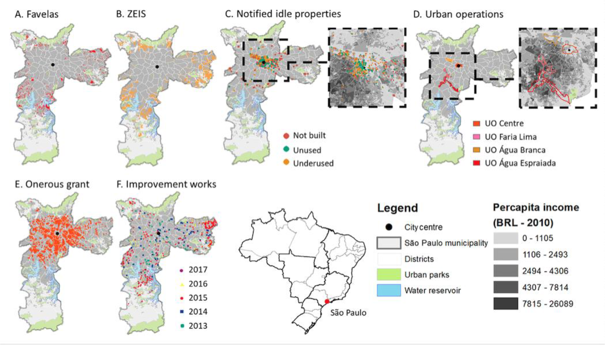
In Brazil, ZEIS (Special Social Interest Zones) are areas designated for affordable housing, with access to infrastructure and job opportunities. They are often located in existing informal settlements, vacant buildings, or empty lots in areas that have experienced urban decay. ZEIS can be useful in addressing housing shortages, improving living conditions, and reducing commute times for low-income groups. However, they have not always led to the desired outcomes in practice. Although the location of ZEIS in São Paulo overlaps with the location of favelas (informal settlements) (figure 3A and 3B), many removals have taken place, indicating non-compliance with zoning laws and master plan provisions. Additionally, the distribution of social groups in São Paulo makes it difficult to secure well-located land for the poorest through ZEIS, as favelas are mostly located in peripheral areas (Carvalho & Cabral, 2021). Finally, ZEIS areas do not coincide perfectly with the distribution of idle properties in central areas, suggesting a lack of integration between planning tools and housing opportunities.

Urban issues and planning tools in São Paulo. (A-B) show informal settlements and ZEIS areas, both distributed away from the Central Business District (CBD). (C) maps idle properties classified as 'Not built', 'Unused', or 'Underused' by the city. (D) shows Urban Consortium Operations (UCO); zoomed views relate idle properties and UCOs to per capita income (in grey). (E-F) display the spatial overlap of onerous grant areas with improvement works by year. Source: Authors. Maps based on GeoSampa (2021).
2.2 Increasing Property Tax ('IPTU Progressivo')
The principle of the social function of property, enshrined in Brazil's Constitution and the City Statute, prioritizes the collective consequences of property use over individual interests. To enforce this principle, municipalities can levy progressively higher property taxes on unused or underused buildings and plots that fail to meet social functions. This regulatory tool promotes the use of intraurban vacant plots or unused buildings with proper sanitary and transportation infrastructure and is employed with the goal of reducing urban sprawl. The tax increase is incremental, reaching up to 15% of the property value within five years, after which the local government may expropriate the property through payment in public debt securities. Most notified vacant properties in São Paulo are concentrated in the central area, with 2,244 owners notified since 2014 and 1,436 of those eligible for the tool's application. However, only 182 owners have complied with obligations or had notifications cancelled (Municipality of São Paulo, 2017). Moreover, Costa and Santoro (2018) point out that these properties did not contribute to increase the supply of social housing, one of the goals of the strategy employed to choose the notified property owners. Notifications to owners decreased from 549 in 2016 to 263 in 2017 and 8 in 2018, reflecting a change in the municipal office in 2017 (Alves 2020). This assessment implies that raising taxes can reduce the housing deficit and promote more equitable cities while minimizing urban sprawl, mobility issues, and real estate speculation. Nonetheless, the tool's implementation remains vulnerable to political interests and preferences. However, Costa and Santoro (2018) argue that its implementation in São Paulo brought important advancements in the form of new procedures and a specific department to deal with issues related to the social function of property.
2.3. Urban Consortium Operations
The Urban Consortium Operation (UCO) is a mechanism that promotes urban development through partnerships between the State and private entities. This initiative designates a specific area where the regulatory framework is modified - usually increasing maximum building rights and relaxing land-use constraints (Siqueira, 2019). Such opportunities are then translated into certificates of additional potential of construction (CEPAC) and sold to private actors. The government utilizes the generated funds to invest in urban improvements within the UCO’s perimeter, such as new transport infrastructure and roads. However, the success of UCOs heavily depends on the real estate market's demand in the area. Consequently, investing in already-developed areas may exacerbate existing spatial inequalities, as São Paulo exemplifies.
In São Paulo, four areas with urban operations exist, all situated near the city centre, with the furthest being UCO Água Espraiada, 15km away from the CBD (see figure 3D). Despite including some lower-income sectors, these areas are predominantly home to higher-income populations and areas of interest to the real estate market. Consequently, infrastructure improvements will likely benefit only those areas that traditionally receive state benefits, potentially reinforcing segregation and gentrification processes. As the literature suggests, such processes may be initiated by the well-known relationship between public investments and the rise in housing prices (Mikelbank 2005; Li et al. 2019), leading to escalating living costs that can impact small establishments and traditional residents (Siqueira 2014). Empirical evidence indicates that the UCO Faria Lima experienced a 14% increase in property values between 1991-1996 and 1996-2001, while prices in the metropolitan region of São Paulo declined 12% during the same period (Biderman et al. 2006). Moreover, UCOs may transform industrial areas into significant real estate projects (e.g. UCO Água Espraiada), generating the risk of gentrifying adjacent neighborhoods and displacing low-income inhabitants.
However, other instruments may be employed simultaneously with UCOs to prevent or mitigate gentrification. For instance, using ZEIS in UCO Água Espraiada allowed low-income communities to relocate to new buildings within the operation's perimeter, preserving their original location (Siqueira 2014). Nonetheless, this outcome may be temporary, as high-income groups already show interest in these apartments, increasing pressure on poorer inhabitants to sell and move to the periphery (Siqueira 2019). Furthermore, the intervention's logic is driven by the interests of those who benefit from the purchase of additional building rights, with the private sector ultimately defining the occupation and development's course. In UCO Água Branca, private developers' compensation was limited to improving the road system that serves their new buildings (Alvim et al. 2011). Moreover, the instrument’s piecemeal logic may lead to interventions that try to solve localised problems and create inconsistencies with existing regulations (Siqueira 2018). This may undermine broader urban development strategies by fragmenting and disconnecting their constituent parts.
2.4. Sale of Building Rights
The Sale of Building Rights (Outorga Onerosa do Direito de Construir- OODC) charges developers for building rights above a certain floor area ratio (FAR), called "basic FAR," to compensate for increased building densities. This tool can be used to encourage or limit development in certain areas. A similar instrument in the City Statute allows municipalities to charge for converting rural to urban land, an essential ally in sprawl containment. In São Paulo, the resources obtained through the sales of building rights are directed to the Municipal Fund for Urban Development (FUNDURB) and used to finance citywide improvements. The OODC has generated an annual 5% increase on average in the Municipal Property Tax, which is applied to public services and utilities in the city (Maleronka and Furtado, 2014). Nobre (2016) reports that the municipality raised, between 2004 and 2014, R$ 1.7 billion (approximately US$654 million at the time). However, while the total amount of floor area building rights was comparable to that sold through urban consortium operations, the price per square meter corresponded to only a third of the latter, showing its relatively lower attractiveness. The São Paulo experience shows that, although the additional constructive potential has been primarily offered in the central area, their investments spread throughout the city, including peripheral areas (figures 3E and 3F). The difference in locational patterns between these variables suggests that the instrument may successfully redistribute public resources and decrease urban inequalities. Various sectors showed improvements, such as cultural projects (e.g. libraries, cultural centres, schools), affordable housing, and urban projects (street networks, bus terminals) (Geosampa, 2021).
3. Discussion: the effectiveness of planning instruments
The City Statute in Brazil provides a legal framework for planners and elected officials to address urban problems using various tools, such as zoning and social housing policies, increased property taxes, urban consortium operations, and the sale of building rights. While these tools may not have specific aims, they can relate to and affect identifiable urban issues. To understand how these tools work in real-world situations, we analyzed their application in São Paulo. This megacity introduced many regulatory instruments while facing issues similar to those in other Brazilian cities. These tools connect with addressing housing deficits and informal settlements, as well as potential effects on reducing residential segregation, stimulating the occupation of central areas, reducing demands for sprawl, and improving mobility by reducing travel distances (Figure 4).

Potential utility of instruments in connection with urban challenges. Continuous arrows in the diagram suggest strong potential relationships; dotted arrows indicate weak links. The red arrows indicate the risk of reversed effects. Source: Authors.
However, our analyses suggest that they have been met with mixed, or at best partial, success levels in addressing such urban problems. They have been found wanting, particularly in critical issues regarding spatial justice and urban performance. Zones of special social interest (ZEIS), designed to allocate land for affordable housing in locations provided with proper infrastructure and with access to jobs, end up correlated with consolidated informal settlements frequently located in the fringes instead of focusing on idle properties in empty lots and vacant buildings, finding severe difficulties in securing housing for the low-income population in central areas. They may have the unintended consequence of increasing the spatial segregation of the poor. Increasing property taxes can be effective, but so far the results have not been promising and their application is highly dependent on the political agenda of elected officials. Urban consortium operations may increase densities, diversify land uses, and, therefore, increase the vitality of public spaces.
On the other hand, their effects on reducing residential segregation are less likely. The instrument may have opposite effects, reinforcing an area’s attractiveness to higher-income groups and displacing original low-income residents, increasing spatial inequalities. Finally, the sale of building rights also relies on a political agenda to redistribute public funds collected through the instrument into areas in need. Additionally, it may be a vulnerability through which building rights are sold to the highest bidder with little or no consideration for locational concerns about density and infrastructure. Poor oversight and accountability increase the risks of urban corruption (Borges and Magalhães 2019).
Our analysis shows that these regulatory tools have had limited effects on reducing the housing deficit, problems in risky areas and favelas, segregation, urban sprawl and travel times. In 2019, São Paulo had 1 million inhabitants registered in a public housing programme. According to the Evictions Observatory (Observatório de Remoções/LabCidade, USP), from 2017 to 2019, 28,000 households were evicted in the Metropolitan Region of São Paulo. These families received a small amount to pay a year's rent - which, in most cases, is not enough. When aid is discontinued, many return to informal settlements (Silva 2019). Regarding travel times, from 2018 to 2019, congestion levels increased by 3% (TomTom 2019). More is needed in regulations and political action if planning is to be effective in dealing systemically with persistent problems in large Brazilian cities.
A path to improve the reach and reliability of planning is a broader convergence between systematic research, precise information on the state of cities and their subsystems, and planning. Evidence-based planning (EBP) (Davoudi 2006; Faludi & Waterhout 2006) prioritizes using empirical data and scientific research to inform decision-making processes. It aims to improve planning outcomes' effectiveness and fairness by grounding them in robust, reliable evidence rather than solely on intuition, tradition, or political expediency. The main goal is to achieve the best possible outcomes by using evidence to identify and implement the most effective strategies. Planning processes adhere to more rigorous standards to ensure the reliability and validity of decisions deployed. Policies and interventions may be continuously monitored and evaluated to assess their effectiveness and to inform future planning efforts.
Planning may also benefit from an interdisciplinary approach, integrating knowledge and methods from various disciplines, including economics, law, sociology, geography, and environmental science. EBP also relies on stakeholder engagement, including the community, policymakers, and experts, to ensure the evidence is relevant and applicable to local contexts. The main benefits include gains in (i) objectivity in decision-making by relying on factual data rather than subjective opinions or political influences; (ii) transparency in the planning process by openly sharing data sources, methodologies, and findings; (iii) accountability by holding planners and policymakers accountable for the outcomes of their decisions by linking them to the evidence used in the planning process; and (iv) adaptability in policies and interventions based on new evidence and changing circumstances.
4. Conclusion: planning as a response to challenges in large Brazilian cities
The task of planning regulations is to guide urban processes in a way that improves cities and the lives of citizens by minimizing negative externalities and unintended consequences. However, the question arises as to how normative models based on past and present processes can guide future, complex and contradictory dynamics of cities, especially in the face of massive inequalities and challenges such as those found in large Brazilian cities. Urban theorist Mike Batty (2018) proposes an optimistic view that while we cannot predict the future of cities, we can invent it. While we cannot predict specific isolated events, we can forecast trends, analyze probabilities, and plan for desired paths. Achieving these paths requires cooperation and control of ongoing processes, but the most challenging question is whether we can fully control such functions. The realistic answer is no, as urban paths are not created top-down by planning agencies but rather emerge from a myriad of social and economic agencies and their interactions, which can result in emerging trends, patterns, collisions, tensions, and problems.
For instance, let us consider the possibility that urban agents find out about new spatial opportunities in a particular area in a city. Their locational decisions might lead to changes in land use, such as increasing the presence of certain types of businesses, which might soon lead to the emergence of a new centrality, progressively changing land values, densities, and built form. Such processes may take short periods, as in the iconic cases in East London or the Prenzlauer Berg in Berlin (e.g., Fenton 2016; Levine 2004). They frequently trigger gentrification processes, leading to transformation in traditional areas, the replacement of the population, and changes in segregation patterns. It is difficult not only to predict but mainly to control bottom-up processes. It is also hard to foresee a way out of this quixotic dilemma - a seemingly inevitable decoupling between the normative realm of planning and the empirical challenges in complex urban situations. Current planning tools-particularly zoning and land-use regulations-have struggled to address the complexities of urbanisation. Overreliance on zoning as a control mechanism is especially problematic. Planning instruments in Brazil still require significant adaptation to match the evolving nature of urban challenges. Even the latest tools under the City Statute fall short in responding to contemporary urban complexity. These issues exemplify ‘wicked problems’ (Rittel and Webber, 1973), meaning problems that are ill-defined and involve solutions that can trigger new problems-such as Transit-Oriented Development or 15-minute city models, which may improve transport and density but also risk driving up local housing costs.
While urban problems in large Brazilian cities are complex and planning faces clear challenges, we do not believe they are inherently unsolvable. Since Rittel and Webber (1973), more systemic and precise approaches to understanding these issues have emerged. Urban problems may be known through approaches of the new science of cities and even guided (see Batty 2013, 2018, 2024). Effective management and regulation of urban processes require sophisticated instruments to monitor and assess the performance of existing infrastructures. There is certainly a need for more precise planning regulations to deal with problems in an accurate spatial sense and take a multifaceted and open approach to develop a more robust responsive capacity. New data and computer-driven instruments, such as the digital twins, or models able to simulate real systems in cities, have recently emerged to offer highly responsive tools to near-real time demands of cities.
Therefore, it is not a question of relinquishing the existing instruments in implementation but recognising their limitations and working to overcome them through new approaches. When well designed and applied, planning instruments can be combined to achieve improvements in related urban issues. Urban policies should consider complementary tools to lead to more systemic and pervasive results in treating such challenges. Contemporary planning in large Brazilian cities must take a multifaceted and open approach to develop a more robust responsive capacity. With this aim in mind, we point out some possible directions to advance current efforts.
-
Going beyond zoning: more disaggregated forms of spatial analysis may lead to more precise approaches to the actual scale of urban problems, e.g. the issue of idle properties in close relation to the micro-scale definition of locations for social and affordable housing or the experience of the Municipality of Santo André (2006), in the state of São Paulo, whose land-use ordinance ties land use parameters to the street hierarchy.
-
Combining and integrating planning instruments: the development and selection of tools may combine successful approaches based on complementarities to be integrated and applied as a coordinated fashion system.
-
Calibrating instruments: Once instruments are applied, calibration involves monitoring and assessing their effects on urban areas and social groups. This has implications for spatial development decisions, such as increasing precision and benefits and reducing negative impacts, e.g., by increasing taxes or subsidies (see Stead 2021).
-
Integrating planning instruments and Planning Support Systems (PSS): can enhance regulation outcomes by improving data collection and monitoring. Tailored technologies and systems can reveal the real-world impacts of planning tools and guide their application. For example, tracking housing programs in informal areas or using mobility data to inform street and transport upgrades. Real-time monitoring of urban flows may also support timely policy adjustments and performance-based planning (Batty, 2007; 2018) as well as actions that are implemented when certain thresholds are met.
-
Evidence-based planning: as a methodological approach emphasising high-quality, empirical evidence to guide planning decisions. Its principles ensure that planning is grounded in systematic knowledge and information about the state (data) and dynamics (theory) of cities and its systems and infrastructures, leading to more effective, equitable, and sustainable development.
These paths comprise possibilities in a broader universe of alternatives, which are far from exhausted here. The most promising hypotheses involve combining instruments at different scales (local, municipal, regional) in close cooperation with citizens, experts, and decision-makers. If they consider specific conditions and forces, these actions can unleash processes with positive impacts. The context of large Brazilian cities is an extraordinary territory for such explorations.
By their very nature, formal systems of rules, diagnostics, and tangible actions inevitably lag behind real-time issues in complex urban environments. Identifying and designing solutions for urban problems require continual feedback from stakeholders and specialised agencies-both of which are limited in size and resources. Nonetheless, planning remains indispensable. While criticisms of top-down action abound, bottom-up processes also face significant challenges and can produce problematic, even catastrophic, collective outcomes, as unintended consequences of individual actions (Schelling 2006; Ostrom 2011). These range from economic inflation and daily traffic jams to real estate markets locked in building types that lead to empty, mono-functional streets, or societal lock-ins on technologies that exacerbate global warming. Because bottom-up processes can develop their own path dependencies (Arthur 1994), they too necessitate careful oversight.
Self-organisation is a key property of complex systems such as cities and societies; however, a frequently overlooked facet of self-organisation is the historical emergence of specialised subsystems precisely to guide interactions and cooperation within these larger systems. Not unlike living systems, urban societies find paths towards internal differentiation into functional subsystems (cf. Luhman 1995). Political institutions, administrative structures and planning systems are among these emergent specialisations. Planning practices and regulations thus extend the logic of specialisation that sustains complex societies worldwide, with functionally diverse subsystems both supporting and limiting each other in the ongoing process of social and material reproduction.
Clearly, planning instruments and policies face their own challenges-frequently proving insufficient, and at times counterproductive. This reflects the persistent tension between limited planning tools, knowledge, political contexts, and a dynamic urban reality. The fact that this interface involves contradiction does not mean that we can do away with planning. In fact, it means we need to constantly work on it. Improved evidence-based knowledge, coupled with emerging data and analytical technologies, can offer more holistic assessments of urban systems-potentially in real-time or near-real-time-to inform faster, more adaptive responses. Yet no instrument alone can alter urban conditions without the consistent involvement of stakeholders and the iterative work of specialised agencies that keep decision-making processes transparent, critical, and up to date.
-
How to cite:
Carvalho, C. L. S., Netto, V. M., & Saboya, R. (2025). Planning in context: Empirical challenges versus normative instruments in large Brazilian cities. urbe. Revista Brasileira de Gestão Urbana, v. 17, e20240139, 2025. https://doi.org/10.1590/2175-3369.017.e20240139
Declaração de disponibilidade de dados
O artigo se concentra em contribuições teóricas ou metodológicas e não há bases de dados relacionadas, de forma que foi dispensado o depósito no SciELO DATA conforme política editorial da revista.
References
- Abramo, P. (2001). Mercado e ordem urbana: Do caos à teoria da localização residencial. Rio de Janeiro: Bertrand Brasil.
-
Alves, J. D. G. (2020). Função social da propriedade ou especulação imobiliária? Revista do Departamento de Geografia, 40, 13-25. https://doi.org/10.11606/rdg.v40i0.163997
» https://doi.org/10.11606/rdg.v40i0.163997 -
Alvim, A., Abascal, E., & Moraes, L. G. (2011). Projeto urbano e operação urbana consorciada em São Paulo: Limites, desafios e perspectivas. Cadernos Metrópole, 13(25). https://revistas.pucsp.br/index.php/metropole/article/view/5988
» https://revistas.pucsp.br/index.php/metropole/article/view/5988 - Apolinário Jr, A., & Canetti, E. B. (2018). Caderno técnico de estudos de viabilidade ANPTrilhos, Ministério das Cidades.
-
Atkinson, R., & Flint, J. (2004). Fortress UK? Gated communities, the spatial revolt of the elites and time-space trajectories of segregation. Housing Studies, 19(6), 875-892. https://doi.org/10.1080/0267303042000293982
» https://doi.org/10.1080/0267303042000293982 - Batty, M. (2007). Planning support systems: Progress, predictions, and speculations on the shape of things to come. CASA Working Paper, 122.
- Batty, M. (2013). The new science of cities. Cambridge, MA: MIT Press.
- Batty, M. (2018). Inventing future cities. Cambridge, MA: MIT Press.
- Batty, M. (2024). The Computable City. Cambridge, MA: MIT Press.
-
Benson, J. F. (2003). What is the alternative? Impact assessment tools and sustainable planning. Impact Assessment and Project Appraisal, 21(4), 261-280. https://doi.org/10.3152/147154603781766185
» https://doi.org/10.3152/147154603781766185 - Bertuglia, C., Clarke, G., & Wilson, A. (Eds.). (1994). Modelling the city: Performance, policy and planning. London: Routledge.
-
Biderman, C., Sandroni, P., & Smolka, M. O. (2006). Large-scale urban interventions: The case of Faria Lima in Sao Paulo. Land Lines (Lincoln Institute of Land Policy) http://bit.ly/3cd4Oxa
» http://bit.ly/3cd4Oxa -
Borges, L. B., & Silva, J. S. M. P. (2019). Corrupção urbanística em sistemas de planejamento e gestão urbanos: Um estudo de caso. Urbe. Revista Brasileira de Gestão Urbana, 11. https://doi.org/10.1590/2175-3369.011.002.ao06
» https://doi.org/10.1590/2175-3369.011.002.ao06 - Brazilian Institute of Geography and Statistics (IBGE). (2018). População em áreas de risco. Rio de Janeiro.
- Caldeira, T. (2000). Cidade de muros: Crime, segregação e cidadania em São Paulo. São Paulo: Edusp.
- Cardoso, A. (2013). O Programa Minha Casa Minha Vida e seus efeitos territoriais. Rio de Janeiro: Letra Capital.
-
Carvalho, C., & Cabral, D. (2021). Beyond the favelas: An analysis of intraurban poverty patterns in Brazil. The Professional Geographer, 73(2), 269-281. https://doi.org/10.1080/00330124.2020.1844571
» https://doi.org/10.1080/00330124.2020.1844571 - Carvalho, C.U., Santos, A. B., & Sanchez, S. (2018). A influência das características sociais no comportamento de viagens. In Proceedings of the 32º Congresso ANPET (pp. 246-256).
- Davoudi, S. (2006). Evidence-based planning: rhetoric and reality. disP-The Planning Review, 42(165), 14-24.
-
Ewing, R., Hamidi, S., Grace, J. B., & Wei, Y. D. (2016). Does urban sprawl hold down upward mobility? Landscape and Urban Planning, 148, 80-88. https://doi.org/10.1016/j.landurbplan.2015.11.012
» https://doi.org/10.1016/j.landurbplan.2015.11.012 - Faludi, A., & Waterhout, B. (2006). Introducing evidence-based planning. disP-The Planning Review, 42(165), 4-13.
- Feldman, S. (1997). O zoneamento ocupa o lugar do plano: São Paulo, 1947-1961. In Anais do 7º ENANPUR (pp. 667-684). Recife: UFPE.
- Fenton, A. (2016). Gentrification in London: A progress report, 2001-2013. CASE Papers (195). Centre for Analysis of Social Exclusion, London, UK.
-
Freeman, G. P. (1985). National styles and policy sectors: Explaining structured variation. Journal of Public Policy, 5(4), 467-496. https://doi.org/10.1017/S0143814X00003287
» https://doi.org/10.1017/S0143814X00003287 - Gehl, J. (2010). Cities for people. London: Island Press.
-
Geosampa. (2021). Mapa digital da cidade de São Paulo.http://geosampa.prefeitura.sp.gov.br/PaginasPublicas/_SBC.aspx
» http://geosampa.prefeitura.sp.gov.br/PaginasPublicas/_SBC.aspx - Harvey, D. (1973). Social justice and the city. Baltimore: John Hopkins University Press.
- Hillier, B. (1996). Space is the machine. Cambridge: Cambridge University Press.
- Hillier, B., & Sahbaz, O. (2005). High-resolution analysis of crime patterns in urban street networks. In Proceedings Space Syntax: 5th International Symposium, Delft.
- Howlett, M. (2009). Governance modes, policy regimes and operational plans. Policy Sciences, 42(1), 73-89.
- Institute for Applied Economic Research (IPEA). (2019). Atlas da violência: Retrato dos municípios brasileiros. Rio de Janeiro.
-
Institute for Applied Economic Research (IPEA). (2020). Atlas do desenvolvimento humano no Brasil. Rio de Janeiro. https://atlasbrasil.org.br/consulta/planilha
» https://atlasbrasil.org.br/consulta/planilha -
Krafta, R., Netto, V.M., & Lima, L. (2011). Urban built form grows critical. Cybergeo: European Journal of Geography, 565. https://doi.org/10.4000/cybergeo.24787
» https://doi.org/10.4000/cybergeo.24787 -
Levine, M.A. (2004). Government policy, the local state, and gentrification: The case of Prenzlauer Berg (Berlin). Journal of Urban Affairs, 26(1), 89-108. https://doi.org/10.1111/j.0735-2166.2004.007.x
» https://doi.org/10.1111/j.0735-2166.2004.007.x -
Li, H., Wang, Q., Deng, Z., Shi, W., & Wang, H. (2019). Local public expenditure, public service accessibility, and housing price in Shanghai, China. Urban Affairs Review, 55(1), 148-184. https://doi.org/10.1177/1078087417702504
» https://doi.org/10.1177/1078087417702504 -
Light, M. T., & Thomas, J. T. (2019). Segregation and Violence Reconsidered. American Sociological Review, 84(4), 690-725. https://doi.org/10.1177/0003122419858731
» https://doi.org/10.1177/0003122419858731 - Luhmann, N. (1995). Social Systems. Stanford University Press.
- Maleronka, C., & Furtado, F. (2014). Concesión onerosa del derecho de construir (OODC). In M.O. Smolka & F. Furtado (Eds.), Instrumentos notables de políticas de suelo en América Latina Ecuador: Lincoln Institute of Land Policy.
-
Massey, D.S. (1996). The age of extremes: Concentrated affluence and poverty in the twenty-first century. Demography, 33(4), 395-412. https://doi.org/10.2307/2061773
» https://doi.org/10.2307/2061773 - Medeiros, V. (2013). Urbis Brasiliae: O labirinto das cidades brasileiras. Brasília: Editora UnB.
-
Merrill, R., & White, L. (2018). Bridging ends and means: The centrality of targets in comparative policy analysis. Journal of Comparative Policy Analysis: Research and Practice, 20(5), 469-485. https://doi.org/10.1080/13876988.2017.1328781
» https://doi.org/10.1080/13876988.2017.1328781 -
Mikelbank, B. A. (2005). Be careful what you wish for: The house price impact of investments in transportation infrastructure. Urban Affairs Review, 41(1), 20-46. https://doi.org/10.1177/1078087405278444
» https://doi.org/10.1177/1078087405278444 -
Municipality of Sao Paulo. (2017). Função social da propriedade: Parcelamento, edificação e utilização compulsórios. https://bit.ly/3l3fouv
» https://bit.ly/3l3fouv -
Municipality of Santo Andre. (2006). Urban macrozone land use, occupation and subdivision law - Law n. 8.836. https://bit.ly/3qy372x
» https://bit.ly/3qy372x -
Nadalin, V., & Igliori, D. (2015). Espraiamento urbano e periferização da pobreza na região metropolitana de São Paulo: Evidências empíricas. EURE (Santiago), 41(124), 91-111. https://doi.org/10.4067/S0250-71612015000300005
» https://doi.org/10.4067/S0250-71612015000300005 - Netto, V. M., Brigatti, E., & Cacholas, C. (2023). From urban form to information: Cellular configurations in different spatial cultures. Environment and Planning B: Urban Analytics and City Science, 50, 239980832211073-161.
- Netto, V. M., Saboya, R. T., & Vargas, J. C. (2022). Does architecture matter to urban vitality? Buildings and the social life of streets and neighbourhoods. Built Environment, 48, 317-340.
-
Netto, V. M., Meirelles, J. V., Pinheiro, M., & Lorea, H. (2018). A temporal geography of encounters. CyberGeo: European Journal of Geography. https://doi.org/10.4000/cybergeo.28985
» https://doi.org/10.4000/cybergeo.28985 -
Netto, V. M., Soares, M. P., & Paschoalino, R. (2015). Segregated networks in the city. International Journal of Urban and Regional Research, 39(6), 1084-1102. https://doi.org/10.1111/1468-2427.12346
» https://doi.org/10.1111/1468-2427.12346 - Newman, O. (1996). Creating defensible space. Washington, DC: U.S. Department of Housing and Urban Development. (Original work published 1972).
-
Nobre, E. (2016). Recuperação da valorização imobiliária para financiamento da transformação urbana. In R. N. Balbim & C. Krause (Eds.), Eixos de estruturação da transformação urbana (pp. 161-215). Rio de Janeiro: IPEA. http://repositorio.ipea.gov.br/handle/11058/7043
» http://repositorio.ipea.gov.br/handle/11058/7043 -
Organisation for Economic Co-operation and Development. (2020). Urban population by city size. https://bit.ly/3rBTwJf
» https://bit.ly/3rBTwJf - Ostrom, E. (2011). Governing the commons: The evolution of institutions for collective action. Cambridge University Press.
-
Pereira, R. H. M., Banister, D., Schwanen, T., & Wessel, N. (2019). Distributional effects of transport policies on inequalities in access to opportunities in Rio de Janeiro. Journal of Transport and Land Use, 12(1), 741-764. https://doi.org/10.5198/jtlu.2019.1523
» https://doi.org/10.5198/jtlu.2019.1523 -
Richardson, J. (2000). Government, interest groups and policy change. Political Studies, 48(5), 1006-1025. https://doi.org/10.1111/1467-9248.00292
» https://doi.org/10.1111/1467-9248.00292 -
Rittel, H.W.J., & Webber, M.M. (1973). Dilemmas in a general theory of planning. Policy Sci 4, 155-169. https://doi.org/10.1007/BF01405730
» https://doi.org/10.1007/BF01405730 -
Rolnik, R. (2015). O Programa Minha Casa Minha Vida nas regiões metropolitanas de São Paulo e Campinas: Aspectos socioespaciais e segregação. Cadernos Metropole, 17(33), 127-154. http://dx.doi.org/10.1590/2236-9996.2015-3306
» http://dx.doi.org/10.1590/2236-9996.2015-3306 - Runhaar, H., Driessen, P. P. J., & Soer, L. (2009). Sustainable urban development and the challenge of policy integration. Environment and Planning B: Planning and Design, 36(3), 417-431.
- Santos Jr, O., & Montandon, D. T. (Eds.). (2011). Os planos diretores municipais pós-Estatuto da Cidade: Balanço crítico e perspectivas Rio de Janeiro, RJ: LetraCapital.
- Schelling, T. C. (2006). Micromotives and macrobehavior. WW Norton & Company.
- Schroeder, T., & Saboya, R. T. (2015). Configurational characteristics of socio-spatial segregation in Brazilian cities. In Proceedings of the 10th International Space Syntax Symposium
-
Sennett, R. (2016, January). The intimate lives of others. Spiked Review http://bit.ly/3rBaasn
» http://bit.ly/3rBaasn -
Sethi, M., Lamb, W., Minx,J., & Creutzig, F. (2020). Climate change mitigation in cities: a systematic scoping of case studies. Environ. Res. Lett., 15(9), 093008, doi:10.1088/1748-9326/ab99ff
» https://doi.org/10.1088/1748-9326/ab99ff - Shukla, P. R., Skea, J., Slade, R., Al Khourdajie, A., van Diemen, R., McCollum, D., ... & Malley, J. (2022). Climate change 2022: Mitigation of climate change. Intergovernmental Panel on Climate Change, 10, 9781009157926.
-
Silva, E. (2019, September 7). São Paulo tem déficit de 474 mil moradias, diz estudo. Folha de São Paulo Retrieved October 20, 2020, from https://bit.ly/30w0zHu
» https://bit.ly/30w0zHu -
Silva, G. J. A., Silva, S. E., & Nome, C. A. (2016). Densidade, dispersão e forma urbana. Arquitextos - Vitruvius, 16(189.07). http://www.vitruvius.com.br/revistas/read/arquitextos/16.189/5957
» http://www.vitruvius.com.br/revistas/read/arquitextos/16.189/5957 -
Siqueira, M. T. (2014). Entre o fundamental e o contingente: Dimensões da gentrificação contemporânea nas operações urbanas em São Paulo. Cadernos Metrópole, 16(32), 391-415. http://dx.doi.org/10.1590/2236-9996.2014-3205
» http://dx.doi.org/10.1590/2236-9996.2014-3205 -
Siqueira, M. T. (2019). Novas políticas urbanas, novas formas de participação social? Os desafios da Operação Urbana Água Espraiada em São Paulo, Brasil. Cadernos Metrópole, 21(45), 417-438. https://doi.org/10.1590/2236-9996.2019-4503
» https://doi.org/10.1590/2236-9996.2019-4503 - Sposito, M. E. B., & Góes, E. M. (2013). Espaços fechados e cidades: Insegurança urbana e fragmentação socioespacial (1st ed.). São Paulo: Editora UNESP.
-
Stead, D. (2021). Conceptualizing the policy tools of spatial planning. Journal of Planning Literature https://doi.org/10.1177/0885412221992283
» https://doi.org/10.1177/0885412221992283 -
Stead, D. (2018). Policy styles and instrument choice for mitigating climate change impacts in the transport sector. Journal of Environmental Planning & Management, 61(14), 2445-2467. https://doi.org/10.1080/09640568.2017.1397505
» https://doi.org/10.1080/09640568.2017.1397505 -
TomTom Traffic Index. (2018). Measuring congestion worldwide. Retrieved October 10, 2018, from https://bit.ly/3qyZAku
» https://bit.ly/3qyZAku -
Ventorim, F. C., & Netto, V. M. (2023). Criminalidade e espaço urbano: As redes de relação entre crime, vítimas e localização no Rio de Janeiro. urbe. Revista Brasileira de Gestão Urbana, 15. https://doi.org/10.1590/2175-3369.015.e20220141
» https://doi.org/10.1590/2175-3369.015.e20220141 - Villaça, F. (1998). Espaço intraurbano no Brasil. São Paulo: Studio Nobel, FAPESP, Lincoln Institute.
- Vivan, M., & Saboya, R. T. (2012). Arquitetura, espaço urbano e criminalidade: Relações entre espaço construído e segurança com foco na visibilidade. In Anais do II ENANPARQ Natal: UFRN.
-
World Bank. (2014). Population living in slums. Retrieved August 13, 2018, from http://bit.ly/3l3E8D4
» http://bit.ly/3l3E8D4 -
World Population Review. (2024). Most violent cities in the world. https://worldpopulationreview.com/country-rankings/most-violent-cities-in-the-world
» https://worldpopulationreview.com/country-rankings/most-violent-cities-in-the-world -
Zandonade, P., & Moretti, R. (2012). O padrão de mobilidade de São Paulo e o pressuposto de desigualdade. EURE (Santiago), 38(113), 77-97. https://dx.doi.org/10.4067/S0250-71612012000100004
» https://dx.doi.org/10.4067/S0250-71612012000100004
Edited by
-
Editor(a) responsável:
Rodrigo Firmino