
 Protected Areas and Geodiversity: Booklets as Teaching Resources for Environmental Education
Abstract
Knowledge of geodiversity plays a fundamental role in nature conservation, yet it remains underexplored in educational contexts, especially in primary and secondary education. This article presents educational booklets developed to support the teaching of geodiversity in five Brazilian protected areas: Serra do Cipó National Park (Minas Gerais), Serra da Bodoquena National Park (Mato Grosso do Sul), Furna Feia National Park (Rio Grande do Norte), Campos Ferruginosos National Park, and Carajás National Forest (both in Pará). The booklets address geological and geomorphological elements and processes that are relevant to understanding the geodiversity of each protected area, with particular emphasis on speleological heritage. The ecosystem services provided by geodiversity in these environments are also presented. The material was written in accessible language for students, particularly those in secondary education, and includes guidance on developing extracurricular activities. The booklets are also intended to support teachers, protected-area managers, and visitor guides by promoting the integration of geodiversity into environmental education practices. The study highlights the potential of geodiversity as a pedagogical resource, contributing to a holistic approach to nature that values both geoconservation and bioconservation and reinforces the importance of abiotic heritage in the educational process.
Keywords:
Geoeducation; Geoconservation; Environmental interpretation; Didactic material; Abiotic heritage
Resumo
O conhecimento sobre a geodiversidade desempenha um papel fundamental na conservação da natureza, mas ainda é pouco explorado no contexto educacional, especialmente no ensino fundamental e no ensino médio. Este artigo apresenta cartilhas didáticas elaboradas para apoiar o ensino de geodiversidade em cinco unidades de conservação brasileiras: o Parque Nacional da Serra do Cipó (Minas Gerais), o Parque Nacional da Serra da Bodoquena (Mato Grosso do Sul), o Parque Nacional da Furna Feia (Rio Grande do Norte), o Parque Nacional dos Campos Ferruginosos e a Floresta Nacional de Carajás (ambos no Pará). As cartilhas abordam elementos e processos geológicos e geomorfológicos relevantes para a compreensão da geodiversidade em cada unidade de conservação, com destaque para o patrimônio espeleológico. Também são apresentados os serviços ecossistêmicos proporcionados pela geodiversidade nesses ambientes. O material foi elaborado em linguagem acessível a estudantes, sobretudo do ensino médio, e inclui subsídios para o desenvolvimento de atividades extraclasse. As cartilhas têm ainda o objetivo de apoiar professores, gestores de unidades de conservação e condutores de visitantes, promovendo a integração da geodiversidade às práticas de educação ambiental. O estudo evidencia o potencial da geodiversidade como recurso pedagógico, contribuindo para uma abordagem holística da natureza, que valoriza tanto a geoconservação quanto a bioconservação e reforça a importância do patrimônio abiótico no processo educativo.
Palavras-chave:
Geoeducação; Geoconservação; Interpretação ambiental; Material didático; Patrimônio abiótico
INTRODUCTION
The concept of geodiversity encompasses the variety of geological, geomorphological, pedological, hydrological and natural processes that make up the Earth's surface (Serrano; Ruiz-Flaño, 2007, Díaz-Martinez, 2010). This set of characteristics not only shapes the landscape, but also directly influences biodiversity, natural resources and human activities (Bruschi, 2007; Andrasanu, 2006; Manosso; Ondicol, 2012). Although geodiversity is widely recognised for its role in nature conservation, few studies have addressed its didactic value or sought ways to disseminate it (Furtado; Valdati, 2023). Recent studies on this subject have pointed to the considerable, and still underexplored, interpretative potential of geodiversity and have proposed strategies for approaching and communicating it (Pinto et al., 2023; Carneiro et al., 2024; Furtado;Valdati, 2023; Georgousis et al., 2022; Mosios et al., 2023; Carrillo‑Hernández et al., 2024).
In this study, a distinction is drawn between “educational potential” and “pedagogical potential” to avoid using the terms interchangeably. “Educational” is understood here as the broad formative reach of the material (informing, raising awareness, broadening repertoires and promoting ways of reading nature in formal and non-formal contexts), whereas “pedagogical” refers to intentionally planned use in teaching, with mediation by teachers/guides, learning objectives and possibilities for assessment and didactic replanning. Thus, a booklet may have high educational potential by supporting awareness-raising and environmental interpretation. Still, its pedagogical potential depends on its integration into teaching sequences, guided-visit itineraries, and structured activities aligned with learning objectives and criteria for monitoring learning.
Although geodiversity encompasses various abiotic components, the operational focus of this study emphasises, above all, geological and geomorphological elements and processes central to environmental interpretation along trails and at visited sites, with particular emphasis on speleological heritage. This focus was adopted to remain consistent with visitation itineraries, the demands identified among local stakeholders, and the didactic objectives of the booklets.
The educational potential of geodiversity lies in its capacity to connect natural phenomena to everyday experience, promoting an integrated understanding of natural systems. Environmental education, by incorporating abiotic heritage, contributes to the development of a broader ecological awareness that goes beyond the traditionally biodiversity-centred view.
Immersive activities in natural settings foster environmental awareness, enabling affective-cognitive interactions that can trigger the re-elaboration of symbolic structures constructed by individuals. Their effectiveness is related to the interpretative strategies adopted, insofar as these facilitate understanding of what is immediately visible during contact with natural elements (Neiman, 2007). From the same perspective, it has been emphasised that an educational project on the abiotic aspects of nature should promote the reconstruction of students’ perceptions regarding the concepts of geodiversity, geoheritage, geoethics and geotourism (Georgousis et al., 2022).
Protected Areas (PAs) provide privileged settings for activities exploring the relationships among geodiversity, biodiversity, and culture. Some studies have also highlighted the importance of proposing ways of approaching geodiversity through activities involving contact with nature, especially in these protected areas, given the uses and the diversity of protected elements and processes found there (Viana et al., 2024; Gordon et al., 2017; Santos et al., 2021; Georgousis et al., 2021; Mayorga, 2022). Brazil currently has more than 2,900 protected areas at the federal, state, and municipal levels (MMA, 2024), many of which stand out for preserving a significant portion of Brazilian speleological heritage, represented by more than 25,000 caves currently known (CECAV, 2024).
Speleological heritage comprises natural underground cavities and the biotic, abiotic, socio-economic, and historical-cultural elements associated with them (Brasil, 2004). Caves occur in different lithologies, especially carbonate, siliciclastic and ferruginous rocks. Approximately one-third of them (31.95%) are distributed across federal, state, and municipal protected areas, both under strict protection and sustainable use categories (ICMBio/CECAV, 2024). The national programme for the conservation of speleological heritage proposes guiding principles and components for the valorisation of this heritage, including knowledge production, dissemination and sustainable use (Brasil, 2009).
National Parks (PARNAs, acronym in Portuguese) belong to the strict-protection category of protected areas; within them, only indirect uses of natural resources are permitted. National Forests (FLONAs, acronym in Portuguese), by contrast, belong to the sustainable-use category, in which some resources may be exploited (Brasil, 2000). Although the scenic aspects of these areas are among their main attractions, environmental education activities related to their abiotic characteristics remain underexplored. It is worth noting that protected areas contain a significant portion of the country’s geodiversity, including a plurality of elements, processes, and features associated with speleological heritage.
Among the objectives of protected areas is encouraging educational activities to disseminate knowledge and raise awareness of nature conservation. Many of them receive nearby schools in fulfilment of this objective; however, in general, teaching activities tend to focus on aspects of local biodiversity (Oliveira de Sá; Carvalho, 2023; Santos et al., 2020; Silva, Silva, 2022).
Given this gap, this paper presents educational booklets developed for four national parks and one national forest in Brazil. Initially, all national parks that preserve part of the country’s speleological heritage were identified. Four representative units from different biomes were then selected, each containing cavities developed in distinct geological groups and with different geological histories. The booklets were designed to facilitate the teaching of geodiversity by providing theoretical and practical support to help readers understand geological and geomorphological processes, while also stimulating interest in the conservation of natural heritage. The study also seeks to discuss the didactic potential of this material and to emphasise the importance of integrating scientific knowledge with educational practices, thereby contributing to the formation of a more aware society that is committed to nature conservation.
MATERIALS AND METHODS
Characterisation of the study areas
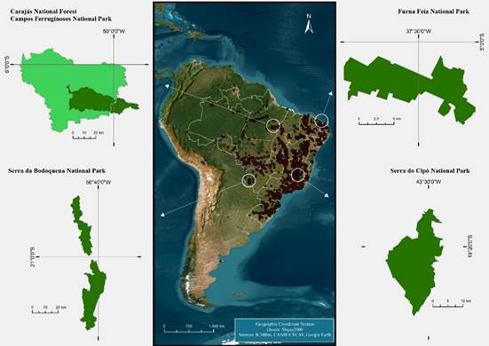
The project involved four distinct areas: Serra do Cipó National Park (PNSC, acronym in Portuguese), in Minas Gerais; Campos Ferruginosos National Park (PNCF, acronym in Portuguese) and Carajás National Forest (FNC, acronym in Portuguese), both in Pará; Serra da Bodoquena National Park (PNSB, acronym in Portuguese), in Mato Grosso do Sul; and Furna Feia National Park (PNFF, acronym in Portuguese), in Rio Grande do Norte (Figure 1).
The PNSC covers an area of 31,617 hectares (ICMBio, 2009) and lies in the southern portion of the Southern Espinhaço Range, distinguished by its geological and geomorphological complexity. This mountainous area, of great scenic beauty, contains numerous waterfalls and clear-water streams and is heavily visited, especially during the warmer months. Within it, Palaeoproterozoic rocks of the Espinhaço Supergroup crop out, predominantly metaquartzites (Knauer, 2007); Neoproterozoic rocks of the Macaúbas Group, deposited approximately 900 Ma ago and composed largely of siliciclastics (Fraga, 2013); Neoproterozoic carbonate rocks of the Bambuí Group, around 750 Ma old (Thomaz Filho et al., 1998; Iglesias; Uhlein, 2009); and Cenozoic alluvial deposits (Saadi, 1995). During the Brasiliano Orogeny, around 600 Ma before present, the closure of the Macaúbas Basin and the formation of the Araçuaí Orogen led to the uplift of the Southern Espinhaço Range (Alkmim et al., 2007). Speleological heritage is present in the different geological groups of the range. In the upper part of the park, sinkholes, resurgences, doline-like landforms, caves and rock shelters developed in the metaquartzites of the Espinhaço Supergroup. Further west, at the foot of the range, metamorphosed carbonates of the Bambuí Group favoured the development of ornamented carbonate caves. Sinkholes, resurgences and caves also occur in the siliciclastic rocks of the Macaúbas Formation.
The PNCF and the FNC protect an area of more than 400,000 hectares (Brasil, 2016; Brasil, 2017). Located in the Carajás Mineral Province, in south-eastern Pará, these protected areas are set within the geological context of the Amazonian Craton. This is considered the country’s most important mineral province because of its large deposits of iron, gold, copper, manganese, molybdenum and nickel (DOCEGEO, 1988; Justo et al., 2013). Mineral exploitation within the National Forest poses challenges for balancing conservation and mining activity (Martins et al., 2018). The present study focused on ferruginous rocks, where most tourist and educational visits are concentrated and where the majority of the caves known in these protected areas are located.
The PNSB covers an area of 76,481 hectares (Brasil, 2013). Carbonate rocks of the Tamengo and Bocaina formations, constituents of the Corumbá Group, predominate in its territory. Its geological evolution is related to the rift phase that occurred around 900 million years ago during the fragmentation of the Rodinia Supercontinent (Campanha et al., 2011). Its geomorphological evolution displays well-developed karst, in which karst cones, canyons, sinkholes and springs, karrenfields, karst pavement, tufa deposits and numerous caves predominate (Sallun Filho et al., 2004).
The PNFF, located in the western portion of Rio Grande do Norte, protects approximately 8,500 hectares of the Caatinga Biome and an important portion of Brazilian speleological heritage (ICMBio, 2020). Carbonate rocks of the Jandaíra Formation, belonging to the Apodi Group, predominate there. The protected area contains some of the youngest limestones in the country, deposited in the Potiguar Basin during the Cretaceous and set within the context of the Atlantic Ocean's formation (Bezerra et al., 2020). Several karst landforms occur in the park, with particular emphasis on extensive karrenfields, regionally known as lajedos.

Methodological procedures
The selection of the four National Parks considered criteria such as geological and geomorphological diversity, the occurrence and relevance of speleological heritage, the potential for environmental education activities, and logistical accessibility. Subsequently, in response to demand from environmental agencies working in the Carajás region (PA), Carajás National Forest (FLONA), which partially overlaps Campos Ferruginosos National Park, was included.
Initially, consultations were conducted through semi-structured interviews with the teams of these protected areas (managers and technical staff), educators, and local tourism guides. The aim was to develop an overview of existing educational uses, considering the frequency of visits, the number of schools, pupils’ educational levels, and existing educational and tourism practices. The interview results enabled identification of the sites most frequently visited during school trips, thereby allowing the integration of geodiversity content into established visitation itineraries. In addition, the number of known caves and other features associated with speleological heritage in each protected area, along with their potential uses, was quantified to construct interpretative itineraries that integrate these aspects.
To align the planned actions with the needs of the target audience, participatory workshops were held, creating a space for the exchange of experiences and the collection of feedback on the educational potential of local geodiversity. Teachers from the public-school system who use the protected areas for educational activities were invited, as were professionals responsible for coordinating educational and tourism visits.
These interactions were fundamental for understanding the dynamics of use and for identifying the most relevant abiotic content. From that point onwards, a broad bibliographical survey was undertaken, including consultations of scientific databases (Scielo, Google Scholar, and Web of Science) and institutional technical reports, with a focus on articles related to geodiversity, environmental education, and the interpretation of natural heritage. Still, during the desk-based stage, GIS databases and satellite imagery were analysed to identify the macro-elements of geodiversity in the vicinity of the sites of interest.
Subsequently, twelve field expeditions were conducted along trails already used for educational activities. During these visits, the sites were georeferenced, and field sheets were completed with descriptions of the observed geological processes. Additional points of interest were also identified to complement interpretative activities, with emphasis on speleological heritage and outstanding geomorphological features (Figure 2). Visits to recognise existing trails and select additional points took place at the PNSC in March, July and October 2021, and in July 2024. In the PNFF, these surveys were undertaken in March and October 2022 and in March 2023. The PNCF and Carajás National Forest were visited in August 2022 and October 2023, while the PNSB was visited in April and September 2023 and in June 2024.
To support the preparation of the booklets, the field stage was also used to build a comprehensive photographic collection, including both broad landscape-scale images and detailed images of geodiversity elements. Aerial (drone) images were also obtained, enabling geological features to be viewed from different perspectives and proving fundamental for improved morphological analysis.
The final office-based stage included preparing complementary illustrations and graphic support materials to improve understanding of the elements and processes associated with the geodiversity of each protected area. After layout and graphic production, visits were made to the protected areas and nearby schools to present the booklets.
The inference of the educational potential of the booklets was carried out qualitatively through triangulation among: (i) semi-structured interviews with managers, educators and guides; (ii) responses and feedback obtained in participatory workshops; (iii) field observation of the correspondence between abiotic content and interpretative stopping points; and (iv) analysis of the final product (the booklets) in terms of conceptual clarity, territorial contextualisation, links with extracurricular experiences, the presence of proposed activities, and suitability for different audiences. It is acknowledged, however, that at this stage no formal assessment was undertaken of the use of cognitive/attitudinal measurement instruments in classrooms or guided visits, which limits the scope of the conclusions and points to an agenda for future research.

Sites of interest for the interpretation of geodiversity. Trevo Cave (A) and Capão dos Palmitos Cave (B), PNSC. Mapinguari Cave (C), Carajás National Forest, and a closed depression (D), PNCF. Toca da Onça Cave (E) and calcareous tufa deposits (F), PNSB. Furna Nova (G) and the Furna Feia lajedo (H), PNFF
RESULTS AND DISCUSSION
Meetings with professionals who use the protected areas for educational and tourism purposes were decisive in shaping both the format and the content of the booklets. Teachers and management teams repeatedly reported that educational activities conducted along the trails focus predominantly on biodiversity. In contrast, geological and geomorphological elements tend to be treated merely as “scenery” or “landscape”, with limited interpretative exploration.
This pattern is consistent with diagnoses pointing to difficulties in the systematic inclusion of geodiversity in school and environmental education, often associated with training gaps, limited availability of teaching materials, and the predominance of biocentric approaches.
In some cases, the lack of awareness of the existence of caves within the protected areas themselves reinforced the need for interpretative qualification of speleological heritage, both for educational actions and for visitation.
In response to these demands, the decision was made to produce accessible and informative teaching materials for teachers, secondary-school pupils, tourism guides, managers, and visitors in general.
The outcome was four educational booklets (Figure 3), designed to present the geodiversity of the protected areas in an illustrative and objective manner, thereby deepening understanding of their abiotic components. The material covers different themes within the geosciences, highlighting elements specific to each protected area, which facilitates their observation and interpretation in the field.

Educational booklets (covers). From left to right: Serra da Bodoquena National Park, Furna Feia National Park, Serra do Cipó National Park, Campos Ferruginosos National Park and Carajás National Forest
Each booklet was named in reference to a relevant abiotic characteristic of the corresponding protected area. In the case of Campos Ferruginosos National Park and Carajás National Forest, for instance, because they are located in the same geographical area, geodiversity was addressed in an integrated way in the booklet entitled “Treasures of the Earth”. Some copies were printed and distributed to the protected areas involved, and the material is also available in digital format, thereby broadening access.
The central axis of each booklet is the description of the geological and geomorphological evolution of the study areas, highlighting geodiversity elements that represent key moments in this trajectory (Chart 1).
Fundamental concepts such as Continental Drift and the Wilson Cycle were presented through illustrations that showed how each protected area fits into these global processes. Considering the speleological context, the geomorphological characteristics, and the educational potential of caves, the discussion focused on the appreciation and conservation of geodiversity. In addition, various ecosystem services associated with abiotic components were exemplified, including water regulation, carbon storage, and contributions to ecosystem stability (Chart 2).
From a didactic point of view, the booklets were structured to link geoscientific concepts to situations observable in the field, favouring environmental interpretation along trails, viewpoints, dolines, karren, sinkholes, springs, resurgences and caves. This organisation responds directly to the gaps identified by local stakeholders. It expands the material's educational potential by making visible the role of the abiotic substrate in the integrated reading of the landscape. However, its pedagogical potential - in the strict sense of planned use in teaching - depends on mediation by teachers/guides and on application strategies (teaching sequences, interpretative itineraries with objectives and activities), which reinforces the need for training and for instruments to monitor learning.
Thus, the results indicate that the booklets are a promising resource for integrating geoconservation and environmental education, but measuring cognitive, attitudinal, and formative impacts requires future studies involving monitored application in school contexts and guided visits.
FINAL REMARKS
In addition to safeguarding a significant share of natural resources, protected areas play an important role in promoting educational activities that provide direct contact with nature. The effectiveness of these actions largely depends on the availability of high-quality teaching materials that engage the target audience and facilitate the interpretation of the natural elements observed.
The material produced proved effective in filling gaps in the teaching of geodiversity, especially by broadening understanding of speleological heritage and other abiotic aspects that are often not explored in traditional educational activities. The results showed that prior lack of knowledge about geodiversity - including among educators and environmental managers - limits the didactic potential of protected areas.
The booklets developed present clear, written, and illustrated content that characterises the elements and processes of geodiversity present in these protected areas, contextualising them within the geological history of the Earth. In this sense, they may contribute not only to the enrichment of educational practices, but also to the valorisation of geodiversity as an essential component of nature conservation. The importance of integrating scientific knowledge into educational practice is also emphasised, promoting an interdisciplinary approach that connects geosciences, ecology and culture.
Several ecosystem services provided by biodiversity and geodiversity are under threat due to current dynamics in natural resource use and consumption. The resulting climate change repeatedly compels us to rethink our relationship with the environment. In this context, strategies of geoconservation and bioconservation become indispensable, and environmental education constitutes a powerful tool for raising society’s awareness of the importance of these issues.
As limitations, it should be noted that, at this stage, the study did not include the systematic application of the booklets in school classes or guided visits, nor the use of formal evaluation instruments (pre-/post-tests, learning rubrics, attitudinal scales, or longitudinal follow-up). Therefore, the conclusions regarding educational and pedagogical potential are based on qualitative evidence (stakeholder demand, territorial fit, and the clarity and applicability of the material) and should be understood as indicative. For future research, it is recommended that implementation of the booklets be tested across different levels of education and visitor profiles, measuring cognitive gains (understanding of geological and geomorphological processes), attitudinal gains (appreciation of abiotic heritage), and formative effects (changes in teaching and guiding practices), in addition to evaluating institutional and training barriers to the continuous adoption of the theme in protected areas.
We believe that the work developed contributes significantly to a more holistic view of nature conservation by integrating geodiversity into environmental education and conservation strategies. The booklet model demonstrates potential for replication across other contexts and biomes, and future research should assess the effectiveness of these materials in diverse educational settings. In this way, the study reinforces the transformative role of education in building a society that is more aware, more critical and more committed to protecting natural and cultural heritage.
ACKNOWLEDGEMENTS
This work was funded through Terms of Commitment for Speleological Compensation (TCCE) no. 01/2020, entered into between ICMBio and Mineração Ferro Puro, and TCCE no. 01/2018, entered into between ICMBio and Vale S.A., to whom we are grateful. The authors also thank CNPq for research productivity fellowships.
DATA AVAILABILITY
The data that support the findings of this study can be made available, upon reasonable request, from the corresponding author [Darcy José dos Santos].
References
- ALKMIM, F. F.; PEDROSA-SOARES, A. C.; NOCE, C. M.; CRUZ, S. C. P. Sobre a evolução tectônica do Orógeno Araçuaí-Congo Ocidental. Genomos, v. 15, n. 1, p. 25-43, 2007.
- ANDRASANU, A. Basic concepts in geoconservation. Mesozoic and Cenozoic Vertebrates and Paleoenvironments. Tributes to the career of Dan Grigorescu, n.10, p. 37-41. 2006.
-
BEZERRA, F. H.; ROSSETI, D. F.; OLIVEIRA, R. G.; MEDEIROS, W. E.; CASTRO, D. L. Postrift stress field inversion in the Potiguar Basin, Brazil - Implications for petroleum systems and evolution of the equatorial margin of South America. Marine and Petroleum Geology, 2020. p. 88-104. https://doi.org/10.1016/j.marpetgeo.2019.08.001
» https://doi.org/10.1016/j.marpetgeo.2019.08.001 - BRASIL, Conselho Nacional de Meio Ambiente (CONAMA). Resolução nº 347, de 10 de setembro de 2004. Dispõe sobre a proteção do patrimônio espeleológico. Diário Oficial da União: Seção 1, Brasília, DF, 13 set. 2004.
-
BRASIL, Ministério do Meio Ambiente. Plano de Manejo da Floresta Nacional de Carajás. Brasília, DF: ICMBio. 2016. Disponível em: https://www.gov.br/icmbio/pt-br/assuntos/biodiversidade/unidade-de-conservacao/unidades-de-biomas/amazonia/lista-de-ucs/flona-de-carajas/arquivos/dcom_icmbio_plano_de_manejo_flona_carajas_volume_i.pdf Acesso em: 12 dez. 2024.
» https://www.gov.br/icmbio/pt-br/assuntos/biodiversidade/unidade-de-conservacao/unidades-de-biomas/amazonia/lista-de-ucs/flona-de-carajas/arquivos/dcom_icmbio_plano_de_manejo_flona_carajas_volume_i.pdf -
BRASIL, Ministério do Meio Ambiente. Plano de manejo do Parque Nacional da Serra da Bodoquena. Brasília, DF: ICMBio, 2013. Disponível em: https://www.gov.br/icmbio/pt-br/assuntos/biodiversidade/unidade-de-conservacao/unidades-de-biomas/cerrado/lista-de-ucs/parna-da-serra-da-bodoquena/plano-de-manejo-/plano-de-manejo-pnsbd/plano-manejo-pnsbd-encarte-1.pdf Acesso em: 12 dez. 2024.
» https://www.gov.br/icmbio/pt-br/assuntos/biodiversidade/unidade-de-conservacao/unidades-de-biomas/cerrado/lista-de-ucs/parna-da-serra-da-bodoquena/plano-de-manejo-/plano-de-manejo-pnsbd/plano-manejo-pnsbd-encarte-1.pdf -
BRASIL, Presidência da República -. Decreto de 05 de junho de 2017 - Dispõe sobre a criação do Parque Nacional dos Campos Ferruginosos, Diário Oficial da União, Brasília, DF, 6 jun. 2017. Disponível em: https://www.gov.br/icmbio/pt-br/assuntos/biodiversidade/unidade-de-conservacao/unidades-de-biomas/amazonia/lista-de-ucs/parna-dos-campos-ferruginosos/arquivos/decreto_sn_de_5_de_junho_2017_cria_parna_dos-campos_ferruginosos.pdf Acesso em: 12 dez.2024.
» https://www.gov.br/icmbio/pt-br/assuntos/biodiversidade/unidade-de-conservacao/unidades-de-biomas/amazonia/lista-de-ucs/parna-dos-campos-ferruginosos/arquivos/decreto_sn_de_5_de_junho_2017_cria_parna_dos-campos_ferruginosos.pdf - BRASIL, Presidência Da República. Lei Nº 9.985, de 18 de julho de 2000. Regulamenta o art. 225, § 1o, incisos I, II, III e VII da Constituição Federal e institui o Sistema Nacional de Unidades de Conservação da Natureza. Brasília, DF, 2000.
- BRASIL. Ministério do Meio Ambiente. Portaria nº 358, de 30 de setembro de 2009. Institui o Programa Nacional de Conservação do Patrimônio Espeleológico. Diário Oficial da União: seção 1, Brasília, DF, 1 out 2009.
- BRUSCHI, V M. Desarrollo de una metodología para la caracterización, evaluación y gestión de los recusos de la geodiversidad. 2007. Tese (Doutorado em Ciencias de la Terra y Fisica de la Materia Condensada). Universidad de Cantabria, Santander, 2007.
-
CAMPANHA, G. A. C.; BOGGIANI, P. C.; SALLUN FILHO, W.; SÁ, F. R.; ZUQUIM, M. P. S.; PIACENTINI, T. A Faixa de dobramento Paraguai na Serra da Bodoquena e Depressão do Rio Miranda, Mato Grosso do Sul. Geologia USP, v. 11, p. 79-96, 2011. https://doi.org/10.5327/Z1519-874X2011000300005
» https://doi.org/10.5327/Z1519-874X2011000300005 -
CARNEIRO, C. D. R.; SILVEIRA, M. C.; MIGUEL, G. F. Roteiro de uso educacional do Modelo 3D da Bacia do Paraná. Terrae Didatica, v. 20, e024041, p.1-15, 2024. https://doi.org/10.20396/td.v20i00.8678347
» https://doi.org/10.20396/td.v20i00.8678347 - CARRILLO HERNÁNDEZ, Y. M.; RÍOS REYES, C. A.; VILLARREAL JAIMES, C. A. Geotourism and geoeducation: A holistic approach for Socioeconomic. Geoheritage, 2024.
-
CECAV. Cadastro Nacional de Informações Espeleológicas (CANIE) 2024. Disponível em: https://sicae.sisicmbio.icmbio.gov.br/usuario-externo/login Acesso em: 15 dez. 2024.
» https://sicae.sisicmbio.icmbio.gov.br/usuario-externo/login -
DÍAZ-MARTINEZ, E. First resolution towards geoconservation at the 4th World Conservation Congress of IUCN. Geotop, v. 66, p. 31-32, 2010. https://doi.org/10.1127/sdgg/66/2010/31
» https://doi.org/10.1127/sdgg/66/2010/31 - DOCEGEO. Revisão litoestratigráfica da Província Mineral de Carajás. In: CONGRESSO BRASILEIRO DE GEOLOGIA, 35, 1988, - Belém. SGB, 1988. p. 11-57.
- FRAGA, L. M. S. Análise estratigráfica do grupo Macaúbas no domínio meridional da Serra do Espinhaço, Minas Gerais. 2013. Tese (Doutorado). Belo Horizonte, 2013.
-
FURTADO, T.; VALDATI, J. Geodiversidade na educação básica. Geografia Ensino & Pesquisa, v. 27, p. 1-33, 2023. https://doi.org/10.5902/2236499472139
» https://doi.org/10.5902/2236499472139 -
GEORGOUSIS, E.; SAVELIDI, M.; SAVELIDES, S.; MOSIOS, S.; HOLOKOLOS, M. V.; DRINIA, H. How Greek Students Perceive Concepts Related to Geosciences. Geosciences, v. 12, 2022. https://doi.org/10.3390/geosciences12040172
» https://doi.org/10.3390/geosciences12040172 -
GEORGOUSIS, E.; SAVELIDI, M.; SAVELIDES, S.; HOLOKOLOS, M. V.; DRINIA, H. Teaching geoheritage values: implementation and thematic analysis evaluation of a Synchronous Online Educational Approach. Heritage, v. 4, p. 3523-3542, 2021. https://doi.org/10.3390/heritage4040195
» https://doi.org/10.3390/heritage4040195 -
GEORGOUSIS, E.; SAVELIDES, S.; MOSIOS, S.; HOLOKOLOS, M. S. The need for geoethical awareness: The Importance of Geoenvironmental Education in Geoheritage Understanding in the Case of Meteora Geomorphes, Greece. Sustainability, v. 13, p. 1-31, 2021. https://doi.org/10.3390/su13126626
» https://doi.org/10.3390/su13126626 -
GOOGLE. Google Earth Pro. Software. Disponível em: https://earth.google.com/ Acesso em: 22 abr. 2025.
» https://earth.google.com/ -
GORDON, J. E.; CROFTS, R.; DIAZ-MARTÍNEZ, E.; WOO, K. S. Enhancing the Role of Geoconservation in Protected Area. Geoheritage, 2017. https://doi.org/10.1007/s12371-017-0240-5
» https://doi.org/10.1007/s12371-017-0240-5 -
ICMBio. Caminhos da Água: descobrindo a geodiversidade do Parque Nacional da Serra da Bodoquena - MS. Brasília: DF: Instituto Chico Mendes - ICMBio, 2025a. Disponível em: https://www.gov.br/icmbio/pt-br/assuntos/centros-de-pesquisa/cavernas/publicacoes/Publicacaoes Acesso em: 20 jul. 2025
» https://www.gov.br/icmbio/pt-br/assuntos/centros-de-pesquisa/cavernas/publicacoes/Publicacaoes -
ICMBio. Entre Furnas e Lajedos: elementos da geodiversidade no Parque Nacional da Furna Feia - RN. Brasília, DF: Instituto Chico Mendes - ICMBio, 2025b. Disponível em: https://www.gov.br/icmbio/pt-br/assuntos/centros-de-pesquisa/cavernas/publicacoes/Publicacaoes Acesso em: 20 jul. 2025.
» https://www.gov.br/icmbio/pt-br/assuntos/centros-de-pesquisa/cavernas/publicacoes/Publicacaoes -
ICMBio. Limites unidades de conservação federais. Disponível em: https://www.gov.br/icmbio/pt-br/assuntos/dados_geoespaciais/mapa-tematico-e-dados-geoestatisticos-das-unidades-de-conservacao-federais Acesso em: 20 jul. 2025.
» https://www.gov.br/icmbio/pt-br/assuntos/dados_geoespaciais/mapa-tematico-e-dados-geoestatisticos-das-unidades-de-conservacao-federais -
ICMBio. Montanhas de Geodiversidade: explorando o Parque Nacional da Serra do Cipó - MG. Brasília, DF: Instituto Chico Mendes - ICMBio, 2025c. Disponível em: https://www.gov.br/icmbio/pt-br/assuntos/centros-de-pesquisa/cavernas/publicacoes/Publicacaoes Acesso em: 20 jul. 2025
» https://www.gov.br/icmbio/pt-br/assuntos/centros-de-pesquisa/cavernas/publicacoes/Publicacaoes -
ICMBio. Plano de manejo do Parque Nacional da Furna Feia. Brasília, DF, 2020. Disponível em: https://www.gov.br/icmbio/pt-br/assuntos/biodiversidade/unidade-de-conservacao/unidades-de-biomas/caatinga/lista-de-ucs/parna-da-furna-feia/arquivos/plano_de_manejo_parna_da_furna_feia.pdf Acesso em: 12 dez. 2024.
» https://www.gov.br/icmbio/pt-br/assuntos/biodiversidade/unidade-de-conservacao/unidades-de-biomas/caatinga/lista-de-ucs/parna-da-furna-feia/arquivos/plano_de_manejo_parna_da_furna_feia.pdf -
ICMBio. Plano de manejo Parque Nacional da Serra do Cipó e Área de Proteção Ambiental Morro da Pedreira. Brasília, DF, 2009. Disponível em: https://www.gov.br/icmbio/pt-br/assuntos/biodiversidade/unidade-de-conservacao/unidades-de-biomas/cerrado/lista-de-ucs/parna-da-serra-do-cipo/arquivos/parna_serra_do_cipo_pm_encarte1e2.pdf Acesso em: 12 dez. 2024.
» https://www.gov.br/icmbio/pt-br/assuntos/biodiversidade/unidade-de-conservacao/unidades-de-biomas/cerrado/lista-de-ucs/parna-da-serra-do-cipo/arquivos/parna_serra_do_cipo_pm_encarte1e2.pdf -
ICMBio. Tesouros da Terra: descobrindo a geodiversidade no Parque Nacional dos Campos ferruginosos e na Floresta Nacional de Carajás - PA. Brasília, DF: Instituto Chico Mendes - ICMBio, 2025d. Disponível em: https://www.gov.br/icmbio/pt-br/assuntos/centros-de-pesquisa/cavernas/publicacoes/Publicacaoes Acesso em: 20 jul. 2025
» https://www.gov.br/icmbio/pt-br/assuntos/centros-de-pesquisa/cavernas/publicacoes/Publicacaoes -
ICMBio/CECAV. Anuário Estatístico do Patrimônio Espeleológico Brasileiro. 2024. Disponível em: https://www.gov.br/icmbio/pt-br/assuntos/centros-de-pesquisa/cavernas/anuario-estatistico-do-patrimonio-espeleologico-brasileiro/anuario-estatistico-do-patrimonio-espeleologico-brasileiro Acesso em 22 fev. 2025.
» https://www.gov.br/icmbio/pt-br/assuntos/centros-de-pesquisa/cavernas/anuario-estatistico-do-patrimonio-espeleologico-brasileiro/anuario-estatistico-do-patrimonio-espeleologico-brasileiro -
IGLESIAS, M.; UHLEIN, A. Estratigrafia do Grupo Bambuí. Revista Brasileira de Geociências, v. 39, p. 256-266, 2009. https://doi.org/10.25249/0375-7536.2009392256266
» https://doi.org/10.25249/0375-7536.2009392256266 - JUSTO, A. P.; SILVA, C. M. G.; TAVARES, F. M.; LOPES, E. C. S.; OLIVEIRA, J. K. M.; COSTA, L. T. R.; SILVEIRA, F. V. Desafios do mapeamento metalogenético regional. 2013. In: SIMPÓSIO DE GEOLOGIA DA AMAZÔNIA, 13, 2013. Anais [...], p. 1021-1028.
- KNAUER, L.G. O Supergrupo Espinhaço em Minas Gerais: Genomos, v. 15, n. 1, p. 81-90, 2007.
-
MANOSSO, F. C.; ONDICOL, R. P. Geodiversidade: Considerações sobre quantificação e avaliação da distribuição especial. Anuário do Instituto de Geociências - UFRJ, p. 90-100, 2012. https://doi.org/10.11137/2012_1_90_100
» https://doi.org/10.11137/2012_1_90_100 - MARTINS, F. D.; KAMINO, L. H. Y.; RIBEIRO, K. T. (orgs.). Projeto Cenários - Conservação de Campos Ferruginosos diante da mineração em Carajás. Tubarão, SC: Copiart, 2018.
-
MAYORGA, A. Reimagining outdoor environmental education. 2022. Disponível em: https://www.proquest.com/openview/377fac969897efcedb74d592e982e03b/1.pdf?cbl=18750&diss=y&pq-origsite=gscholar Acesso em: 15 dez. 2024.
» https://www.proquest.com/openview/377fac969897efcedb74d592e982e03b/1.pdf?cbl=18750&diss=y&pq-origsite=gscholar -
MMA, Ministério do Meio Ambiente. Painel Unidades de Conservação Brasileiras. Disponível em: https://app.powerbi.com/view?r=eyJrIjoiMGNmMGY3NGMtNWZlOC00ZmRmLWExZWItNTNiNDhkZDg0MmY4IiwidCI6IjM5NTdhMzY3LTZkMzgtNGMxZi1hNGJhLTMzZThmM2M1NTBlNyJ9&pageName=ReportSectione0a112a2a9e0cf52a827 Acesso em: 28 jan. 2025.
» https://app.powerbi.com/view?r=eyJrIjoiMGNmMGY3NGMtNWZlOC00ZmRmLWExZWItNTNiNDhkZDg0MmY4IiwidCI6IjM5NTdhMzY3LTZkMzgtNGMxZi1hNGJhLTMzZThmM2M1NTBlNyJ9&pageName=ReportSectione0a112a2a9e0cf52a827 -
MOSIOS, S.; GEORGOUSIS, E.; DRINIA, H. The Status of Geoethical Thinking in the Educational System of Greece: An Overview. Geosciences, v. 13, 2023. https://doi.org/10.3390/geosciences13020037
» https://doi.org/10.3390/geosciences13020037 - NEIMAN, Z. A Educação Ambiental através do contato dirigido com a natureza. 2007. Tese (Doutorado). Universidade de São Paulo, 2007.
-
OLIVEIRA DE SÁ, A. C.; CARVALHO, E M. E. S. Reflexões sobre a geodiversidade e a biodiversidade nas unidades de conservação de Sergipe. Geographia Meridionalis, v. 7, 2023. https://doi.org/10.15210/gm.v7i.27393
» https://doi.org/10.15210/gm.v7i.27393 -
PINTO, A. M.; SILVA, L. F.; WEBER, A. K. P. S. Ensino não formal e divulgação das Geociências por meio da Educação Ambiental. Terrae Didatica, v. 19, e023011, p. 1-10, 2023. https://doi.org/10.20396/td.v19i00.8672229
» https://doi.org/10.20396/td.v19i00.8672229 -
SAADI, A. A geomorfologia da Serra do Espinhaço em Minas Gerais e suas margens. Genomos, v. 3, n. 1, p. 41-63, 1995. https://doi.org/10.20396/td.v19i00.8672229
» https://doi.org/10.20396/td.v19i00.8672229 - SALLUN FILHO, W.; KARMANN, I.; BOGGIANI, P. C. Paisagens cársticas da Serra da Bodoquena (MS). In: MONTESSO-NETO, V.; BARTORELLI, A.; CARNEIRO, C. D. R.; BRITO-NEVES, B. B. (org.) Geologia do Continente Sul-Americano: Evolução da Obra de Fernando Flávio Marques de Almeida. São Paulo: Beca, 2004. p. 423-433
-
SANTOS, D. J.; RUCHKYS, Ú. A.; TRAVASSOS, L. E. P. The Educational Potential of Geodiversity in Ferruginous Geosystem: the Example of the Quadrilátero Ferrífero, Minas Gerais, Brazil. Geoheritage, v. 13, 2021. https://doi.org/10.1007/s12371-021-00550-2
» https://doi.org/10.1007/s12371-021-00550-2 - SANTOS, J.M., SILVA GONZAGA, P.C., OLIVEIRA, P.V. Geodiversity in the school environment: an analysis of national theses and dissertations. Research, Society and Development, v. 10, 2020.
-
SERRANO, E.; RUIZ-FLAÑO, P. Geodiversity: A theoretical and applied concept. Geographica Helvetica, v. 62, p. 140-147, 2007. https://doi.org/10.5194/gh-62-140-2007
» https://doi.org/10.5194/gh-62-140-2007 -
SILVA, H. V. M.; SILVA, L. P. Conservação da geodiversidade e valoração didática da Cachoeira de Santo Antônio. Entre-Lugar, v. 16, 2022. https://doi.org/10.30612/rel.v16i31.18244
» https://doi.org/10.30612/rel.v16i31.18244 - THOMAZ FILHO, A.; KAWASHITA, K.; CORDANI, U. G. A origem do Grupo Bambuí no contexto da evolução geotectônica e das idades radiométricas. Anais da Academia Brasileira de Ciências, v. 70, p. 527-547, 1988.
-
VIANA, M. S. S.; LIMA, T. A.; PEREIRA, A. M.; VIANA, R. S. Educação Patrimonial como estratégia de geoconservação no Parque Nacional de Ubajara. Terrae Didatica, v. 20, e024021, p. 1-7, 2024. https://doi.org/10.20396/td.v20i00.8675563
» https://doi.org/10.20396/td.v20i00.8675563
-
ASSOCIATE EDITOR:
Silvio Carlos Rodrigues. https://orcid.org/0000-0002-5376-1773

 Source: The authors (2024).
 Source: