
 Sediment Production in Tropical Catchments: An Integration of USLE and Index of Connectivity in Antonina, Southern Brazil
Abstract
This study analyzes sediment production and export in basins draining into Antonina Bay (PR), using the Universal Soil Loss Equation (USLE), the Connectivity Index (CI), and the Sediment Delivery Rate (SDR) to calculate an effective sediment export index (Eeffective). The study region encompasses the Cachoeira, Pequeno, Cacatu, and Faisqueira river basins, located in a fluviomarine dam area, where agricultural use is concentrated on alluvial deposits. The results indicate that the USLE predicts average losses ranging from 1.29 to 3.11 t ha-1 yr-1 per basin. In contrast, the Eeffective reduces losses by 70 to 72% (0.36 to 0.88 t ha-1 yr-1), considering retention and disconnectivity along the slopes. Low-elevation regions associated with agricultural use, particularly in the Lower Cachoeira River, are the main points of sediment production and export. The USLE, IC, and Eefetivo maps indicate that most of the transported sediment does not reach the outlet, highlighting the role of connectivity. Thus, combining estimates of potential erosion with connectivity metrics can improve the spatial representation of sediment export and guide conservation measures (no-till farming, agroforestry systems, and riparian forest restoration) to reduce coastal siltation and determine priority areas for restoration.
Keywords:
Hydrosedimentological Connectivity; Soil Loss; Sedimentation
Resumo
Este estudo analisa a produção e o transporte de sedimentos em bacias hidrográficas que deságuam na baía de Antonina (PR), por meio da aplicação da Equação Universal de Perda de Solos (USLE), do Índice de Conectividade (IC) e da Taxa de Entrega de Sedimentos (SDR), com o objetivo de calcular um índice de exportação efetiva de sedimentos (Eefetivo). A área de estudo compreende as bacias dos rios Cachoeira (Alto e Baixo), Pequeno, Cacatu e Faisqueira, situadas em uma planície fluviomarinha, onde o uso agrícola se concentra nos depósitos aluvionares. Os resultados mostram que a USLE estima perdas médias de sedimentos variando de 1,29 a 3,11 t ha-1 ano-1 entre as bacias. Em contrapartida, o Eefetivo reduz essas perdas em 70 a 72% (0,36-0,88 t ha-1 ano-1), ao considerar os efeitos de retenção dos sedimentos e desconectividade dos canais ao longo das bacias. As áreas de menor altitude, associadas ao uso agrícola, especialmente no Baixo Cachoeira, destacam-se como principais zonas de produção e exportação de sedimentos. Os mapas de USLE, IC e Eefetivo revelam que a maior parte dos sedimentos transportados não alcança o exutório. A integração de estimativas de erosão potencial com métricas de conectividade aprimora a representação espacial da exportação de sedimentos e subsidia ações de manejo e conservação (como plantio direto, sistemas agroflorestais e recuperação de matas ciliares), visando reduzir o assoreamento costeiro e orientar a definição de áreas prioritárias para recuperação ambiental
Palavras-chave:
Conectividade Hidrossedimentológica; Perda de Solo; Assoreamento
INTRODUCTION
Sheet erosion is one of the most significant soil-degradation processes, characterized by the continuous and relatively uniform removal of surface particles by runoff (Bertoni et al., 2012; Kopittke et al., 2025). Although often underestimated due to its low visibility compared to gully or ravine erosion, its cumulative effects can lead to substantial losses of fertile soil, compromising agricultural productivity and environmental sustainability (Morgan, 2005; Poesen, 2018). Globally, sheet erosion is estimated to account for the loss of billions of tons of soil each year, with direct implications for food security and ecosystem functioning (Pimentel et al., 1995; Borrelli et al., 2017; Quinton; Fiener, 2023; Xiong; Leng, 2024).
Sheet erosion is particularly critical in tropical and subtropical regions, where intense rainfall promotes the removal of the most fertile surface horizons and ultimately reduces agricultural productivity. Additional impacts include siltation, environmental degradation, and increased restoration costs (Labrière et al., 2015).
Soil-loss rates vary widely among catchments: approximately 15 t ha-1 year-1 in the Jacaré-Guaçu River catchment in São Paulo, southeastern Brazil (Souza, 2016), and more than 48 t ha-1 year-1 in the Juramento River catchment in Minas Gerais, also in southeastern Brazil (Oliveira; Leite, 2018). In agricultural areas with exposed temporary crops, losses can be even greater, reaching around 51.6 t ha-1 year-1, whereas under forest cover they decrease to only 3-4 kg ha-1 year-1 (Marinhescki, 2016). In Paraná (southern Brazil), estimates range from 10 t ha-1 year-1 (Souza et al., 2018) to 15-20 t ha-1 year-1 in intensively managed areas (Krug, 2020), with hotspots exceeding 50-100 t ha-1 year-1 in exposed soils and access roads, and peak values up to 355 t ha-1 year-1 (Souza et al., 2018). This spatial heterogeneity highlights the need for soil-conservation practices, vegetation restoration, and road-management strategies in critical areas (Krug, 2020; Demarchi, et al.,2019; Xiong; Leng, 2024).
Beyond reducing soil fertility, sheet erosion contributes to the silting of rivers, lakes, and reservoirs, decreasing water availability and increasing dredging costs (ANA, 2020). Dredging is costly and causes significant environmental impacts in estuarine environments (Paula et al., 2006), including hydraulic and sedimentological alterations such as changes in circulation patterns, water-column mixing, and increased turbidity (Liu et al., 2010). Contaminant remobilization, such as trace metals and organic compounds, frequently occurs, affecting water quality and aquatic organisms (Monte et al., 2019; Moreira et al., 2021). Sediment removal also alters benthic habitats, reducing feeding and breeding areas and intensifying socio-environmental conflicts associated with dredging operations (Castro; Almeida, 2012).
The combined effects of siltation and repeated dredging emphasize the magnitude of the challenges faced in estuarine systems. In this context, the Paranaguá Estuarine Complex (PEC), located on the coast of Paraná, southern Brazil, stands out for its hydrodynamic, ecological, and geochemical complexity. Between 2009 and 2015, approximately 23.5 × 10⁶ m³ of sediments were dredged in the PEC, requiring investments of 365.8 million reais by the Paranaguá and Antonina Port Authority (APPA - Associação de Portos de Paranaguá e Antonina) (Neto et al., 2017).
Siltation in the area results from the accumulation of sediments derived from the catchments surrounding the Port Complex, produced by natural processes often intensified by inadequate land use (Rutyna et al., 2021). This dynamic is particularly concerning given the increasing operational pressure on the port complex, which depends on maintaining navigability. In 2022, the PEC received 2,540 vessels, rising to 2,933 in 2023; that year, it handled 65.39 million tons of cargo and generated a net operating revenue of R$ 620.96 million (Portos do Paraná, 2023; 2024). These conditions reinforce the importance of understanding sediment sources and the processes controlling sediment production and delivery to the system.
Understanding these processes is essential for guiding management actions, especially in systems under high logistical pressure such as the PEC. Modeling tools are fundamental for assessing basin susceptibility to sediment generation. Advances in computational modeling, such as the Universal Soil Loss Equation (USLE) and its variations (RUSLE, MUSLE), have enabled the prediction of high-risk areas and the optimization of management and restoration strategies (Renard et al., 1997; Borrelli et al., 2021; Kumar et al., 2022). These models estimate potential sediment production but do not account for factors controlling sediment transfer and retention along watersheds.
Sediment moves through watersheds along slopes and channel networks (Bracken et al., 2015). To address the limitations of traditional models and better represent sediment flow, metrics such as the Index of Connectivity (IC) (Borselli et al., 2008) have been used to evaluate the efficiency of transporting eroded material to the drainage network. The IC is directly related to the Sediment Delivery Ratio (SDR), which quantifies the fraction of sediments effectively delivered to watercourses (Ferro; Minacapilli, 1995), thereby allowing the estimation of effective sediment export (Eeffective), the portion of total erosion that reaches basin outlets (Vigiak et al., 2012).
Given that total sediment production differs from the exported volumes, this article applies USLE, IC, SDR, and Eeffective to identify areas of highest sediment generation and export in the basins draining into Antonina Bay, southern Brazil, and to discuss the factors that intensify these processes in the region.
METHODS
Study Area
The study area comprises the catchments of the Cachoeira (upper and lower), Pequeno, Cacatu, and Faísqueira rivers, located in the municipality of Antonina, State of Paraná, southern Brazil (Figure 1). These basins are adjacent to the PEC and form part of the Degraded Areas Recovery Program (PRAD) within the Guaraqueçaba Environmental Protection Area. The program was implemented in the municipality of Antonina by the state-owned public company Paraná Ports as a requirement associated with dredging works carried out to deepen the navigation channel, access routes, and berths of the Port of Paranaguá.

The studied drainage basins exhibit a strong predominance of forest cover, ranging from 88% to 95%, whereas agricultural land occupies relatively small areas, between 4% and 11%. Basin sizes vary from 103 to 180 km². Regarding average slope, the values show notable differences among the basins: upper Cachoeira and Cacatu present the highest mean slopes (34% and 31%, respectively), while lower Cachoeira and Faísqueira display the lowest averages (18% and 20%) (Table 1).
The region is characterized by vegetation formations typical of the Atlantic Forest, ranging from montane and high-montane forests in the Serra do Mar to pioneering fluviomarine and fluviolacustrine communities associated with the coastal plain (Roderjan, 2002; LAGEAMB, 2023). In the municipality of Antonina, approximately 87% of the territory is covered by forest vegetation (Souza et al., 2020).
Among the anthropogenic land uses, diversified agriculture stands out, including rice, cassava, corn, banana, orange, and other crops (Figure 2). These activities are heavily concentrated in flat areas near rivers, where soils developed from fluvial deposits predominate (Ipardes, 2025).

Landscapes of the study area. A) Bridge over the Cachoeira River, lower course. B) Pequeno River; C) Cachoeira River, upper course; D) Landscape of the coastal plain, with the Serra do Mar mountain range in the background. E) Agricultural area on the coastal plain
The drainage area of Antonina Bay is predominantly underlain by high-grade metamorphic rocks, especially migmatites and gneisses, along with Archean and Proterozoic crystalline complexes. The region also includes the Guaratubinha Formation with its basic dikes, Tertiary deposits of the Alexandra Formation, and extensive Holocene sediments, particularly alluvial deposits (Salamuni; Rocha, 2002; Angulo, 2004).
The climate is classified as humid subtropical (Cfa) in the lowlands and humid mesothermal subtropical (Cfb) in the mountainous areas, with an average annual rainfall of 2,273 mm. Summer is the wettest season, with monthly totals exceeding 300 mm, whereas winter precipitation generally remains below 150 mm (ClimateData, 2024; ITCG, 2008; Goudard; Paula, 2016).
The predominant soils in the region are Acrisols, Cambisols, Gleysols, Leptosols and Fluvisols. Acrisols occur mainly in the less rugged portions of the Serra do Mar mountain range and in hilly areas, generally associated with Cambisols. These, in turn, are widely distributed in the Serra do Mar, and may occur in isolation or in association with other classes, especially in colluvial areas, hills, and mountains. Fluvisols are concentrated in valley bottoms, where they may occur alongside Gleysols, which also predominate in these environments, generally in isolation. Leptosols are characteristic of the mountainous portions of the Serra do Mar, while Fluvisols develop in fluvial environments (Paula, 2010).
Estimation of Sediment Production
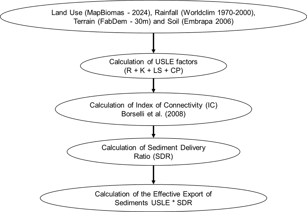
The analysis of sediment production and connectivity in the study area was carried out using multiple complementary approaches. Direct soil loss was estimated using the Universal Soil Loss Equation (USLE). Sediment connectivity was evaluated through the Index of Connectivity (IC). These two components were then integrated by applying the Sediment Delivery Rate (SDR), which enabled the estimation of the effective sediment export index (Eeffective) (Borselli et al., 2008; Vigiak et al., 2012; Cavalli et al., 2013) (Figure 3).

The USLE (Wischmeier; Smith, 1965; 1978) was applied to estimate potential sheet erosion in the study area. The USLE estimates average annual soil loss (t ha-1 year-1) based on climatic, topographic, pedological, and land-management factors (Equation 1):
-
Where:
- A = average annual soil loss (t ha-1 year-1)
- R = rainfall erosivity factor (MJ mm ha-1 h-1 year-1)
- K = soil erodibility factor (t ha h ha-1 MJ-1 mm-1)
- LS = topographic factor (slope length and slope steepness)
- C = land cover and management factor
- P = conservation practices factor
Rainfall Erosivity - R Factor
The R factor represents the erosive potential of rainfall (Figure 4), integrating both the intensity and duration of precipitation events. In this study, it was calculated using the equation proposed by Lombardi Neto and Moldenhauer (1992), which estimates erosivity based on monthly and annual precipitation data (Equation 2):
-
Where
- 𝑝 is the average monthly precipitation (mm)
- P is the average annual precipitation (mm)
The precipitation data were obtained from the WorldClim climatic database (Fick; Hijmans, 2017), with a spatial resolution of 1 km, corresponding to the 1970-2000 climatological normal.

Soil Erodibility - K Factor
The K factor reflects the soil's susceptibility to erosion (Figure 5). This factor can be determined in the laboratory or by empirical equations (e.g., Wischmeier nomogram). However, for application in larger areas, it is common to assign K values to mapped soil units, such as those of the Brazilian Soil Classification System (SiBCS). For this study, we used values adapted from the literature (Table 2) (Mello et al., 2007; Coelho et al., 2024). The soil data used were obtained from the work of Bhering et al., (2007) at a scale of 1:250.000.

Length/slope - LS Factor
The LS factor (Figure 6) represents the combined influence of slope length and gradient on soil erosion. This factor quantifies how topographic characteristics control erosion potential and is calculated through a mathematical formulation that integrates terrain geometry (Desmet; Govers, 1996).
The Digital Elevation Model (DEM) used to derive the LS factor was obtained from the FABDEM project (Forest and Buildings Removed from the Copernicus DEM). FABDEM is derived from the global Copernicus DEM and provides elevation data at 30 m spatial resolution, delivered on a 1-arc-second grid (approximately 30 m at the equator) (Hawker et al., 2022).
Reference values of 22.1 m for slope length and 0.09 (equivalent to approximately a 9% slope) were adopted in the calculation (Equation 3).
-
Where:
- AF = Flow accumulation
- S = Slope

Land Use and conservation practices - CP Factor
The CP factor represents the combined effect of land use and management (C) and conservation practices (P). The C factor expresses the relationship between soil loss under a given vegetation cover and management condition and the soil loss observed on bare ground, serving as an indicator of the protection provided by vegetation or surface residues. The P factor is associated with mechanical conservation practices-such as contour farming, terracing, and buffer strips-which reduce surface runoff velocity and enhance water infiltration.
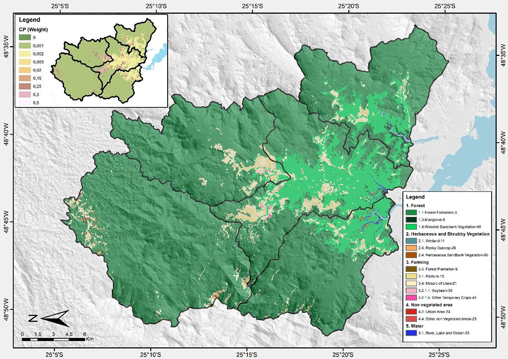
The product of these two components results in the CP value, which ranges from 0 to 1. Values close to zero indicate high conservation efficiency and lower soil loss, whereas values near 1 reflect the absence of conservation measures. In this study, the CP factor (Table 3 and Figure 7) was assigned based on the land use and land cover mapped for the year 2024, with a 30-m spatial resolution (Souza et al., 2020), following parameter values recommended in the literature for similar environmental conditions (Miqueloni et al., 2012; Souza; Gasparetto, 2012).

Index of Connectivity (IC)
Since USLE calculates soil loss at the cell level within the raster matrices, it was necessary to incorporate complementary indices to characterize sediment connectivity dynamics in the study area. In this context, the Index of Connectivity (IC) (Borselli et al., 2008; Cavalli et al., 2013) was applied to estimate the efficiency of sediment transfer from hillslopes to the drainage network (Equation 4).
-
Where
- Dup (potential contribution) is related to the contributing area and average slope of the hillside.
- Ddn (resistance / distance to the channel) is the shortest path to drainage, weighted by slope and land use/cover
Equation 5 was used to calculate the potential contribution (Dup):
-
Where
- Ai = accumulated contributing area in the cell
- θi = slope of the cell
Equation 6 was used to calculate the channel distance variable - Ddn:
-
Where
- di = distance to the canal
- Ci = land cover factor (derived from the land use and occupation map)
Sediment Delivery Rate (SDR) and Effective Sediment Production Index (Eeffective)
The effective sediment export from the watershed was estimated by integrating the Universal Soil Loss Equation (USLE/RUSLE) with the Sediment Delivery Ratio (SDR). The SDR represents the fraction of eroded soil that effectively reaches the drainage network and is controlled by the degree of connectivity within the watershed (Borselli et al., 2008; Vigiak et al., 2012).
To estimate SDR in a spatially distributed manner, a logistic function was employed in which the Index of Connectivity (IC) acts as the explanatory variable, following approaches implemented in recent hydrosedimentological connectivity models (Cavalli et al., 2013; López-Vicente et al., 2013; Sharp et al., 2020) (Equation 7):
-
Where
- a corresponds to the intercept of the logistic function
- b to the slope coefficient that controls the slope of the curve
Reference values for a and b were proposed by Vigiak et al., (2012) from calibrations in experimental basins in Europe, being a≈−0.56a \approx -0.56a≈−0.56 and b≈0.17b \approx 0.17b≈0.17. These parameters can be adjusted according to the local reality of each study.
The effective export of sediments (Eeffective) corresponds to the volume of material that is transferred from the slope to the drainage system. Its estimation considers the product of the potential soil loss, calculated using the Universal Soil Loss Equation (USLE), and the sediment delivery factor (SDR) (Equation 8):
RESULTS
Soil loss by USLE
Areas most prone to soil loss are concentrated in environments with greater anthropogenic disturbance (Figure 8). Among the hydrographic basins, the highest concentration of elevated values occurs in the Lower Cachoeira basin. Significant sediment production also occurs in the Pequeno and Upper Cachoeira basins.
Average sediment production values are 1.44 t ha-1 year-1 in the Faisqueira basin, 2.32 t ha-1 year-1 in the Pequeno River basin, 2.85 t ha-1 year-1 in the Upper Cachoeira, 1.29 t ha-1 year-1 in the Cacatu basin, and 3.11 t ha-1 year-1 in the Lower Cachoeira basin.

Index of Connectivity
The Index of Connectivity (IC) values reflect the capacity of slopes to transfer sediments to the drainage network and are primarily controlled by slope gradient, proximity to channels, and vegetation cover density (Figure 9). Interfluve zones and areas with gentler terrain generally exhibit very low to medium connectivity, indicating a greater likelihood of sediment being retained before reaching the drainage network. In contrast, high and very high connectivity values are concentrated on the steepest slopes (greater than 15%) and along the main and secondary drainage channels, which act as preferential corridors for sediment transport toward watercourses.

Effective sediment export index (Eeffective)
The effective sediment export index (t ha-1 year-1) for the study area (Figure 10) provides an estimate of the spatial variability of soil loss that effectively reaches the drainage network. Most of the area exhibits low export values (<1 t ha-1 year-1), indicating relative stability and a reduced risk of sediment delivery to watercourses. However, certain sectors, particularly those adjacent to agricultural areas and along the Cachoeira River (highlighted in the figure 2e), show export rates exceeding 10 t ha-1 year-1. These zones represent critical areas, functioning as hotspots of soil degradation and high sediment-generation potential.

DISCUSSION
The results indicate that the USLE tends to overestimate soil loss rates (Benavidez et al., 2018; Alewell et al., 2019; Meinen; Robinson, 2021), whereas its integration with the IC and SDR helps mitigate this limitation (Table 4), yielding spatial patterns that more closely reflect observed conditions (Souza et al., 2025). This variation is consistent with findings from tropical and temperate regions (Borselli et al., 2008; Vigiak et al., 2012). The occurrence of higher sediment production in highly connected areas reinforces the role of land use in shaping hydrosedimentological dynamics. Nevertheless, the combination of low altitudes, agricultural land use, and elevated soil loss in the Antonina Bay region underscores the environmental vulnerability of the system.
The results indicate average annual soil losses ranging from 1.29 to 3.11 t ha-1 year-1 according to the USLE, and from 0.36 to 0.88 t ha-1 year-1 for Eeffective, corresponding to reductions greater than 70% when accounting for drainage connectivity. These values fall within the range reported for other watersheds in the Atlantic Forest (Fernandes et al, 2014), although they remain relatively high compared with areas under greater forest preservation.
In the Posses Stream watershed (state of Minas Gerais - southeast of Brazil), where extensive ecological restoration programs have been implemented, sediment production measured in experimental plots ranged from 0.01 to 0.05 t ha-1 year-1, indicating extremely low export rates (Gomes et al., 2017). Conversely, in basins characterized by varying levels of Atlantic Forest cover (state of Rio de Janeiro - southeast of Brazil), sediment export monitored at the basin outlet ranged from 0.11 to 0.46 t ha-1 year-1, while USLE estimates reached up to 5.24 t ha-1 year-1, illustrating the method’s tendency to overestimate potential erosion compared with measured sediment loads (Fernandes et al., 2014).
At the continental scale, a European Union assessment indicated that only approximately 15% of predicted gross erosion reaches watercourses, with most sediments being trapped or deposited across the landscape (JRC, 2018). This pattern is widely documented: in basins with limited connectivity, effective export typically represents only a fraction of potential erosion. In the Ethiopian Rift, RUSLE-based estimates indicated erosion rates of 10-20 t ha-1 year-1, but only 21% of this material was delivered to the drainage network (Alemayehu et al., 2025). In mountainous Mediterranean basins, observations highlight high hydrosedimentological variability and strong control of connectivity on sediment delivery (Francke et al., 2018). Similarly, in southern Italy, rainfall-erosivity models indicated that only a small portion of generated material was exported, with most sediment retained within the basin (Diodato et al., 2024).
The values obtained in this study, particularly those from the Eeffective model (0.4 to 0.8 t ha-1 year-1), are consistent with estimates reported for partially vegetated Atlantic Forest watersheds (Fernandes et al., 2014), although they remain higher than those documented in areas under continuous forest cover (Gomes et al., 2017). This contrast highlights the strong influence of land use and land cover on sediment export and reinforces the importance of integrating drainage connectivity into soil loss estimates.
The comparison between USLE and Eeffective demonstrates a marked reduction in soil loss values once connectivity is considered, producing results more consistent with those observed in other Atlantic Forest studies. Although based on different methodologies, the values obtained here also align with estimates generated by Rutyna et al., (2021), who, using a morphopedological and morphometric approach (Crepani et al., 2001), reported average sediment production between 0.42 and 0.88 t ha-1 year-1 for the same basins draining into Antonina Bay. The similarity strengthens the consistency of the Eeffective index in capturing the effective export of sediments, mitigating the overestimation inherent to the standalone USLE (Benavidez et al., 2018; Alewell et al., 2019; Meinen; Robinson, 2021).
In the Antonina Bay region, land use emerges as the main factor driving sediment production, an effect also observed in other Brazilian biomes. Although not a central focus of this study, it is important to note that the Parigot de Souza Hydroelectric Plant, inaugurated in 1971, diverted part of the Capivari River flow into the Cachoeira River, increasing its annual discharge by approximately 33% (Soares; Santos, 2009). This change altered the hydrogeomorphological balance of the watershed and enhanced sediment export toward the coastal system, contributing to the silting of Antonina Bay.
Examples from other Brazilian biomes illustrate similar patterns. In the Cerrado, intensive agricultural expansion has increased sediment export (Oliveira; Leite et al., 2018; Magalhães et al., 2023), a trend also observed in the lower Cachoeira and Pequeno basins (Table 4; Figure 9). In the Amazon, deforestation for pasture increases hydrosedimentological connectivity (Barbosa; Fearnside, 2000), while in the Atlantic Forest, inadequate management on steep terrain intensifies erosion (Panachuki et al., 2011). Despite regional particularities, interactions between relief, land use, and connectivity exhibit recurrent patterns, reinforcing the relevance of integrated methodologies such as the one applied in this study.
From a geomorphological perspective, areas with steeper slopes generally present greater susceptibility to sediment production. However, in the study area, these zones are predominantly covered by dense vegetation, which effectively inhibits erosive processes. Moreover, their greater distance from major floodplains limits the likelihood that eroded material will reach the main channels (Paula et al., 2010). The Eeffective index corroborates this pattern, indicating that most sediments produced in these environments do not reach the drainage network.
To further illustrate these relationships, Figure 11 presents the association between the minimum elevation of first-order watersheds (m) and soil loss (t ha-1 year-1). The distribution of data points shows that minimum elevation does not significantly explain the variation in estimated erosion, as indicated by the low R² value. Most watersheds with high losses (>10 t ha-1 year-1) are located at elevations below 400 m. In contrast, above 600 m, soil loss values become sparse and remain close to zero. This pattern demonstrates that lower-lying areas near floodplains and Antonina Bay, where agricultural activities are concentrated, are more susceptible to elevated soil loss.
Conversely, basins situated at higher elevations, generally associated with better-preserved forest cover, and reduced anthropogenic pressure, exhibit minimal soil loss regardless of local topography. This contrast underscores the predominant role of land use and land cover in controlling erosion, outweighing the isolated influence of elevation.

When the estimated values are compared with field measurements (Souza et al., 2025), a strong relationship emerges between land use and sediment production. Bare soil areas exhibit the highest losses (0.035 t ha-1 year-1), a value approximately 25 times greater than that recorded under native forest cover (0.0014 t ha-1 year-1). Conventional agriculture (0.0064 t ha-1 year-1) and agroforestry systems (0.0065 t ha-1 year-1) show intermediate values, markedly lower than those observed for bare soil, yet still above the levels associated with native vegetation. These findings demonstrate that forest cover provides the most effective protection against erosion. They also reinforce that even the highest field-measured losses (0.035 t ha-1 year-1 under exposed soil) remain lower than the estimates derived from USLE or from the Effective erosion values (Table 5).
FINAL CONSIDERATIONS
The results show that the isolated application of the USLE substantially overestimates soil loss when compared with estimates obtained by integrating it with the Index of Connectivity (IC) and the Sediment Delivery Ratio (SDR). Incorporating these parameters reduced potential erosion values by approximately 70%, indicating that most of the mobilized material is retained on slopes before reaching the drainage network. This finding directly highlights the importance of accounting for hydrosedimentological connectivity to more accurately represent actual sediment export.
The spatial analysis revealed that the highest soil-loss rates are concentrated in low-altitude areas with intensive agricultural use, particularly within alluvial plains, whereas higher-elevation regions covered by native forest exhibit minimal losses. The study therefore provides a detailed spatial assessment of the most vulnerable sectors, contributing to a clearer understanding of the geomorphological and anthropogenic controls on erosive dynamics. The resulting products, especially the IC and Eeffective maps, constitute valuable tools for environmental planning, enabling the identification of critical areas and guiding the allocation of priority management actions. Based on these results, the adoption of practices such as no-till agriculture, agroforestry systems, riparian forest maintenance, and improved land-use regulation in highly connected sectors is recommended, as these measures can significantly reduce sediment input to watercourses.
Finally, the methodology proved robust, compatible with readily accessible datasets, and replicable in humid tropical basins. The study directly advances erosion and sediment connectivity assessments, providing technical support for public policies related to water management, soil conservation, and the mitigation of siltation in environmentally sensitive regions.
ACKNOWLEDGMENT
We thank the Port Administration of Paranaguá and Antonina (APPA) for funding the project "Evaluation of soil loss and sediment production due to water erosion in experimental plots".
DATA AVAILABILITY
The data that support the findings of this study can be made available, upon reasonable request, from the corresponding author [José Guilherme de Oliveira].
References
-
AGÊNCIA NACIONAL DE ÁGUAS E SANEAMENTO BÁSICO (Brasil). Conjuntura dos recursos hídricos no Brasil: informe 2020. Brasília: ANA, 2020. 118 p., il. Disponível em: https://biblioteca.ana.gov.br/sophia_web/acervo/detalhe/87742 Acesso em: 20 nov. 2025.
» https://biblioteca.ana.gov.br/sophia_web/acervo/detalhe/87742 -
ALEMAYEHU, S.; GETAHUN, E.; JOTHIMANI, M. Spatial and temporal analysis of soil erosion and sediment yield in the shafe watershed, main ethiopian rift region: integrating RUSLE model, GIS, and remote sensing techniques. Discover Sustainability, v. 6, n. 584, 2025. https://doi.org/10.1007/s43621-025-01427-y
» https://doi.org/10.1007/s43621-025-01427-y -
ALEWELL, C.; BORRELLI, P.; MEUSBURGER, K.; PANAGOS, P. Using the USLE: Chances, challenges and limitations of soil erosion modelling. International Soil and Water Conservation Research, v. 7, n. 3, p. 203-225, 2019. https://doi.org/10.1016/j.iswcr.2019.05.004
» https://doi.org/10.1016/j.iswcr.2019.05.004 -
ANGULO, R. J. Mapa do Cenozóico do litoral do Estado do Paraná. Boletim Paranaense de Geociências. Curitiba, v. 55, p. 25-42, 2004. https://doi.org/10.5380/geo.v55i0.4281
» https://doi.org/10.5380/geo.v55i0.4281 -
BENAVIDEZ, R.; JACKSON, B.; MAXWELL, D.; NORTON, K. A review of the (Revised) Universal Soil Loss Equation ((R) USLE): With a view to increasing its global applicability and improving soil loss estimates. Hydrology and Earth System Sciences, v. 22, n. 11, p. 6059-6086, 2018. https://doi.org/10.5194/hess-22-6059-2018
» https://doi.org/10.5194/hess-22-6059-2018 -
BARBOSA, R. I.; FEARNSIDE, P. M. Erosão do solo na Amazônia: Estudo de caso na região do Apiaú, Roraima, Brasil. Acta Amazonica, v. 30, n. 4, p. 601-601, 2000. https://doi.org/10.1590/1809-43922000304613
» https://doi.org/10.1590/1809-43922000304613 - BERTONI, J.; LOMBARDI NETO, F. Conservação do solo. 8. ed. São Paulo: Ícone, 2012.
-
BHERING, S. B.; DOS SANTOS, H. G.; MANZATTO, C. V.; BOGNOLA, I. A.; FASOLO, P. J.; DE CARVALHO, A. P.; CURCIO, G. R. Mapa de solos do estado do Paraná. Rio de Janeiro: Embrapa Solos, 2007. https://www.infoteca.cnptia.embrapa.br/infoteca/handle/doc/339505
» https://www.infoteca.cnptia.embrapa.br/infoteca/handle/doc/339505 -
BORRELLI, P.; ROBINSON, D. A.; FLEISCHER, L. R.; LUGATO, E.; BALLABIO, C.; ALEWELL, C.; PANAGOS, P. An assessment of the global impact of 21st century land use change on soil erosion. Nature Communications, v. 8, n. 1, 2017. https://doi.org/10.1038/s41467-017-02142-7
» https://doi.org/10.1038/s41467-017-02142-7 -
BORRELLI, P.; ALEWELL, C.; ALVAREZ, P.; ANACHE, J. A. A.; BAARTMAN, J.; BALLABIO, C.; PANAGOS, P. Soil erosion modelling: A global review and statistical analysis. Science of the Total Environment, v. 780, n. 146494, 2021. https://doi.org/10.1016/j.scitotenv.2021.146494
» https://doi.org/10.1016/j.scitotenv.2021.146494 -
BORSELLI, L.; CASSI, P.; TORRI, D. Prolegomena to sediment and flow connectivity in the landscape: A GIS and field numerical assessment. Catena, v. 75, n. 3, p. 268-277, 2008. https://doi.org/10.1016/j.catena.2008.07.006
» https://doi.org/10.1016/j.catena.2008.07.006 -
BRACKEN, L. J.; TURNBULL, L.; WAINWRIGHT, J.; BOGAART, P. Sediment connectivity: a framework for understanding sediment transfer at multiple scales. Earth Surface Processes and Landforms, v. 40, p. 177-188, 2015. https://doi.org/10.1002/esp.3635
» https://doi.org/10.1002/esp.3635 - BURROUGH, P. A.; MCDONNELL, R. A. Principles of geographical information systems. Oxford: Oxford University Press, 1998.
-
CASTRO, S. M.; ALMEIDA, J. R. Dragagem e conflitos ambientais em portos clássicos e modernos: uma revisão. Sociedade & Natureza, v. 24, n. 3, p. 519-534, 2012. https://doi.org/10.1590/S198245132012000300011
» https://doi.org/10.1590/S198245132012000300011 -
CAVALLI, M.; TREVISANI, S.; COMITI, F.; MARCHI, L. Geomorphometric assessment of spatial sediment connectivity in small Alpine catchments. Geomorphology, v. 188, p. 31-41, 2013. https://doi.org/10.1016/j.geomorph.2012.05.007
» https://doi.org/10.1016/j.geomorph.2012.05.007 -
CLIMATE-DATA. Antonina Climate (Brazil). 2024. Disponível em: https://en.climate-data.org/southamerica/brazil/parana/antonina-28608 /. Acesso em: 20 nov. 2025.
» https://en.climate-data.org/southamerica/brazil/parana/antonina-28608 -
COELHO, M. R.; LUMBRERAS, J. F.; AMARAL, A. J. do; VASQUES, G. M.; BACA, J. F. M.; DART, R. de O.; PEDREIRA, J. P. das N. C. Erodibilidade dos solos do Brasil. Rio de Janeiro: Embrapa Solos , 38 p., 2024. Disponível em: https://www.infoteca.cnptia.embrapa.br/infoteca/handle/doc/1170044
» https://www.infoteca.cnptia.embrapa.br/infoteca/handle/doc/1170044 -
COLMAN, C. B.; GARCIA, K. M. P.; PEREIRA, R. B.; SHINMA, E. A.; LIMA, F. E.; GOMES, A. O.; OLIVEIRA, P. T. S. Different approaches to estimate the sediment yield in a tropical watershed. Revista Brasileira de Recursos Hídricos, v. 23, 2018. https://doi.org/10.1590/23180331.231820170178
» https://doi.org/10.1590/23180331.231820170178 -
CREPANI, E.; MEDEIROS, J.S.; AZEVEDO, L.C.; DUARTE, V.; HERNANDEZ, P.; FLORENZANO, T.; BARBOSA, C. Sensoriamento Remoto e geoprocessamento aplicados ao zoneamento Ecológico-Econômico e ao ordenamento territorial. INPE: São José dos Campos, São Paulo, 2001. Disponível em: http://sap.ccst.inpe.br/artigos/CrepaneEtAl.pdf Acesso em: 20 nov. 2025.
» http://sap.ccst.inpe.br/artigos/CrepaneEtAl.pdf -
DEMARCHI, J. C.; PIROLI, E. L.; ZIMBACK, C. R. L. Estimativa de perda de solos por erosão na bacia hidrográfica do Ribeirão das Perobas (SP) nos anos 1962 e 2011. RAEGA - O Espaço Geográfico Em Análise, v. 46, n. 1, p. 110-131, 2019. https://doi.org/10.5380/raega.v46i1.56746
» https://doi.org/10.5380/raega.v46i1.56746 -
DERPSCH, R.; FRIEDRICH, T.; KASSAM, A.; LI, H. Current status of adoption of no-till farming in the world and some of its main benefits. International Journal of Agricultural and Biological Engineering, v. 3, n. 1, p. 1-25, 2010. 10.3965/j.issn.1934-6344.2010.01.0-0
» https://doi.org/10.3965/j.issn.1934-6344.2010.01.0-0 -
DESMET, P. J.; GOVERS, G. A GIS procedure for automatically calculating the USLE LS factor on topographically complex landscape units. Journal of Soil and Water Conservation, v. 51, n.5, p. 427-433, 1996. https://doi.org/10.1080/00224561.1996.12457102
» https://doi.org/10.1080/00224561.1996.12457102 -
DIODATO, N.; BORRELLI, P.; GÓMARA, I. Sediment loss modelling framework for the Bradano River Basin, southern Italy, 1950-2020. Theoretical and Applied Climatology, v. 155, p. 829-843, 2024. https://doi.org/10.1007/s00704-023-04662-3
» https://doi.org/10.1007/s00704-023-04662-3 -
EUROPEAN COMMISSION. Joint Research Centre (JRC). Net erosion and sediment transport using WaTEM/SEDEM (for EU). 2018. Dataset. Disponível em: http://data.europa.eu/89h/jrc-esdac-111 Acesso em: 25 nov. 2025.
» http://data.europa.eu/89h/jrc-esdac-111 - FERNANDES, M.M.; CEDDIA, M. B.; RAMOS, G. M.; GASPAR, A.; MOURA, M. R. Influence of land use on water quality of watershed Glória Macaé - RJ. Engenharia Ambiental (Unipinhal. Impresso), v. 8, p. 105, 2011.
-
FERNANDES, M. M.; CARVALHO, D. F.; CEDDIA, M. B.; FRANCELINO, M. R. Valoração ambiental do efeito externo da erosão em duas sub-bacias com diferentes percentuais de mata atlântica. Bioscience Journal, (Online), v. 30, n. 2, p. 411-420, 2014. Disponível em: https://seer.ufu.br/index.php/biosciencejournal/article/view/17989 Acesso em: 25 nov. 2025.
» https://seer.ufu.br/index.php/biosciencejournal/article/view/17989 -
FERRO, V.; MINACAPILLI, M. Sediment delivery processes at basin scale. Hydrological Sciences Journal, v. 40, n. 6, p. 703-717, 1995. https://doi.org/10.1080/02626669509491460
» https://doi.org/10.1080/02626669509491460 -
FICK, S. E.; HIJMANS, R. J. WorldClim 2: new 1‐km spatial resolution climate surfaces for global land areas. International Journal of Climatology, v. 37, n. 12, p. 4302-4315, 2017. https://doi.org/10.1002/joc.5086
» https://doi.org/10.1002/joc.5086 -
FRANCKE, T.; FOERSTER, S.; BROSINSKY, A.; SOMMERER, E.; LOPEZ-TARAZON, J. A.; GÜNTNER, A.; BRONSTERT, A. Water and sediment fluxes in Mediterranean mountainous regions: Comprehensive dataset for hydro-sedimentological analyses and modelling in a mesoscale catchment (River Isábena, NE Spain). Earth System Science Data, v. 10, n. 2, p. 1063-1075, 2018. https://doi.org/10.5194/essd-10-1063-2018
» https://doi.org/10.5194/essd-10-1063-2018 -
GARCÍA-RUIZ, J. M.; BEGUERÍA, S.; NADAL-ROMERO, E.; GONZÁLEZ-HIDALGO, J. C.; LANA-RENAULT, N.; SANJUÁN, Y. A meta-analysis of soil erosion rates across the world. Geomorphology, v. 239, p. 160-173, 2015. https://doi.org/10.1016/j.geomorph.2015.03.008
» https://doi.org/10.1016/j.geomorph.2015.03.008 - GOUDARD, G.; PAULA, E.V. O clima do litoral do Paraná: variabilidades, mudanças climáticas, tendências e desafios. In: BOLDRINI, E. B.; PAES, L. S. O. P.; PINHEIRO, F. (Org.). Clima: Boas Práticas de Adaptação. 1ed. Antonina: Ademadan, 2016, v. 1, p. 13-29.
-
GOMES, M. A. F.; PEREIRA, L. C.; FIGUEIREDO, R. de O.; TOSTO, S. G. Perdas de água e de sedimentos em uma topossequência sob as coberturas de pastagem e de mata nativa na sub-bacia do ribeirão das posses, município de Extrema/MG. Campinas: Embrapa Monitoramento por Satélite, 2017. Comunicado Técnico, 41. ISSN 1415-2118. Disponível em: https://www.infoteca.cnptia.embrapa.br/infoteca/handle/doc/1085465 Acesso em: 25 nov. 2025.
» https://www.infoteca.cnptia.embrapa.br/infoteca/handle/doc/1085465 -
HAWKER, L.; UHE, P.; PAULO, L.; SOSA, J.; SAVAGE, J.; SAMPSON, C.; NEAL, JFA. 30 m global map of elevation with forests and buildings removed. Environmental Research Letters, v. 17, n. 2, 2022. https://doi.org/10.1088/1748-9326/ac4d4f
» https://doi.org/10.1088/1748-9326/ac4d4f -
IPARDES. Paraná Institute for Economic and Social Development. Paraná Agriculture, 2025. Disponível em: https://www.ipardes.pr.gov.br/Pagina/Agropecuaria-Paranaense Acesso em: 20 nov. 2025.
» https://www.ipardes.pr.gov.br/Pagina/Agropecuaria-Paranaense -
ITCG. INSTITUTO DE TERRAS CARTOGRAFIA E GEOLOGIA. Mapa de Climas do Estado do Paraná: clima segundo classificação de Köppen. Curitiba: ITCG, 2008. Disponível em: https://www.iat.pr.gov.br/sites/agua-terra/arquivos_restritos/files/documento/2020-07/mapa_climas_a3.pdf Acesso em: 20 nov. 2025.
» https://www.iat.pr.gov.br/sites/agua-terra/arquivos_restritos/files/documento/2020-07/mapa_climas_a3.pdf - IUSS WORKING GROUP WRB. World Reference Base for Soil Resources: international soil classification system for naming soils and creating legends for soil maps. 4. ed. Vienna: International Union of Soil Sciences (IUSS), 2022.
-
KOPITTKE, P. M.; HARPER, S. M.; ASIO, L. G.; ASIO, V. B.; BATALON, J. T.; BATUIGAS, A. M. T.; GONAZAGA, J. R. A. B.; GONZAGA, N. R.; GUZMÁN, M. T. L. de; LUMANAO, D. J. M.; MCKENNA, B. A.; SOYON, G. B.; VERGARA, J. R. M.; SANCHEZ, P. B. Soil degradation: An integrated model of the causes and drivers. International Soil and Water Conservation Research , v. 13, n. 4, 2025. https://doi.org/10.1016/j.iswcr.2025.07.010
» https://doi.org/10.1016/j.iswcr.2025.07.010 - KRUG, E. T. S. Estimativa de perda de solo por erosão laminar em função de suas características e diferentes níveis de precipitação. 2020. Dissertação (Mestrado em tecnologias computacionais para o Agronegócio) Universidade Tecnológica Federal do Paraná, Medianeira, 2020.
-
KUMAR, M.; SAHU, A. P.; SAHOO, N.; DASH, S. S.; RAUL, S. K.; PANIGRAHI, B. Global-scale application of the RUSLE model: a comprehensive review. Hydrological Sciences Journal , v. 67, n. 5, 2022. https://doi.org/10.1080/02626667.2021.2020277
» https://doi.org/10.1080/02626667.2021.2020277 -
LABRIÈRE, N.; LOCATELLI, B.; LAUMONIER, Y.; FREYCON, V.; BERNOUX, M. Soil erosion in the humid tropics: A systematic quantitative review. Agriculture, Ecosystems & Environment, v. 203, p. 127-139, 2015. https://doi.org/10.1016/j.agee.2015.01.027
» https://doi.org/10.1016/j.agee.2015.01.027 - LAGEAMB - LABORATÓRIO DE GEOPROCESSAMENTO E ESTUDOS AMBIENTAIS. Mapeamento da cobertura vegetal e uso da terra no litoral do Paraná. Curitiba: Universidade Federal do Paraná, 2023.
- LIU, G.-F.; ZHANG, Z.-Y.; LIU, H.-Q.; ZHONG, J.-C.; YAN, S.-H.; FAN, C.-X. Effects of sediment dredging on benthos community structure and water quality in Zhushan Bay. Huan Jing Ke Xue, v. 31, n. 11, p. 2645-2651, nov. 2010.
-
LOMBARDI NETO, F.; MOLDENHAUER, W. C. Rainfall erosivity: Its distribution and relationship with soil loss at Campinas, state of São Paulo, Brazil. Bragantia, v. 51, p. 189-196, 1992. https://doi.org/10.1590/S0006-87051992000200009
» https://doi.org/10.1590/S0006-87051992000200009 -
LÓPEZ-VICENTE, M.; POESEN, J.; NAVAS, A.; GASPAR, L. Predicting runoff and sediment connectivity and soil erosion by water for different land use scenarios in the Spanish Pre-Pyrenees. Catena , v. 102, p. 62-73, 2013. https://doi.org/10.1016/j.catena.2011.01.001
» https://doi.org/10.1016/j.catena.2011.01.001 -
MAGALHÃES, W. D. A.; AMORIM, R. S. S.; HUNTER, M. O. H.; BOCUTI, E. D.; DI LORETO DI RAIMO, L. A.; DA SILVA, W. M.; DE ABREU, D. C. Using the GeoWEPP Model to Predict Water Erosion in Micro-Watersheds in the Brazilian Cerrado. Sustainability, v. 15, n. 6, 2023. https://doi.org/10.3390/su15064711.
» https://doi.org/10.3390/su15064711 - MARINHESKI, V. Aspectos sobre a erosão pluvial em usos agropecuários. Revista ESPACIOS, v. 37, n. 5, 2016.
-
MEINEN, B. U.; ROBINSON, D. T. Agricultural erosion modelling: Evaluating USLE and WEPP field-scale erosion estimates using UAV time-series data. Environmental Modelling & Software, v. 137, e104962, 2021. https://doi.org/10.1016/j.envsoft.2021.104962.
» https://doi.org/10.1016/j.envsoft.2021.104962 -
MELLO, C. R. D.; SÁ, M. A. C. D.; CURI, N.; MELLO, J. M. D.; VIOLA, M. R.; SILVA, A. M. D. Erosividade mensal e anual da chuva no Estado de Minas Gerais. Pesquisa Agropecuária Brasileira, v. 42, p. 537-545, 2007. https://doi.org/10.1590/S0100-204X2007000400012
» https://doi.org/10.1590/S0100-204X2007000400012 -
MIQUELONI, D. P.; BUENO, C. R. P.; FERRAUDO, A. S. Análise espacial dos fatores da equação universal de perda de solo em área de nascentes. Pesquisa Agropecuária Brasileira , v. 47, p. 1358-1367, 2012. https://doi.org/10.1590/S0100-204X2012000900021
» https://doi.org/10.1590/S0100-204X2012000900021 -
MONTE, C. N. do N.; RODRIGUES, A. P. C.; FREITAS, A. R.; FREIRE, A. S.; SANTELLI, R. E.; BRAZ, B. F.; MACHADO, W. Dredging impact on trace metal behavior in a polluted estuary: a discussion about sampling design. Brazilian Journal of Oceanography, v. 67, 2019. https://doi.org/10.1590/S1679-87592019022706701
» https://doi.org/10.1590/S1679-87592019022706701 -
MOREIRA, L. B.; CASTRO, Í. B.; FILLMANN, G.; PERES, T. F.; BELMINO, I. K. C.; SASAKI, S. T.; TANIGUCHI, S.; BÍGECO, M. C.; MARINS, R. V.; LACERDA, L. D.; COSTA-LOTUFO, L. V.; ABESSA, D. M. S. Dredging impacts on the toxicity and development of sediment quality values in a semi-arid region (Ceará state, NE Brazil). Environmental Research, v. 193, e110525, 2021. https://doi.org/10.1016/j.envres.2020.110525
» https://doi.org/10.1016/j.envres.2020.110525 - MORGAN, R. P. C. Soil erosion and conservation. 3. ed. Oxford: Blackwell, 2005.
-
NETO, J. A. S.; DE SOUZA, M. C.; TRZASKOS, B.; JOSÉ, R. Possibilidade de aproveitamento dos sedimentos de dragagem do porto de Paranaguá. Quaternary and Environmental Geosciences, v. 8, n. 2, p. 55-61, 2017. https://doi.org/10.5380/abequa.v8i2.54333
» https://doi.org/10.5380/abequa.v8i2.54333 -
OLIVEIRA, W. F.; LEITE, M. E. Perda de solo por erosão hídrica em bacia hidrográfica: o caso da área de drenagem da barragem do rio Juramento, no norte do estado de Minas Gerais. Revista Caminhos de Geografia. v. 19, n. 67, p. 16-37, 2018. https://doi.org/10.14393/RCG196702
» https://doi.org/10.14393/RCG196702 -
PANACHUKI, E.; BERTOL, I.; ALVES SOBRINHO, T.; OLIVEIRA, P. T. S. D.; RODRIGUES, D. B. B. Perdas de solo e de água e infiltração de água em Latossolo Vermelho sob sistemas de manejo. Revista Brasileira de Ciência do Solo, v. 35, p. 1777-1786, 2011. https://doi.org/10.1590/S010006832011000500032
» https://doi.org/10.1590/S010006832011000500032 -
PAULA, E. V. D.; CUNICO, C.; BOLDRINI, E. B. Controle do assoreamento e dos contaminantes por meio da gestão de bacias hidrográficas para o planejamento das dragagens portuárias na Baía de Antonina/Paraná/Brasil. RA’EGA: O espaço geográfico em análise. Curitiba, v. 12, p. 195-210, 2006. https://doi.org/10.5380/raega.v12i0.4545
» https://doi.org/10.5380/raega.v12i0.4545 - PAULA, E. V.; SANTOS, L. J. C.; UBER, J. A. Análise da suscetibilidade geopedológica à produção de sedimentos na área de drenagem da Baía de Antonina/PR. Revista de Geografia, v. 2, p. 134-147, 2010.
-
PIERZYNSKI, G. M.; VANCE, G. F.; SIMS, J. T. Soils and environmental quality. CRC press, 2005. https://doi.org/10.1201/b12786
» https://doi.org/10.1201/b12786 -
PIMENTEL, D.; HARVEY, C.; RESOSUDARMO, P.; SINCLAIR, K.; KURZ, D.; MCNAIR, M.; BLAIR, R. Environmental and economic costs of benefits. Science, v. 267, n. 5201, p. 1117-1123, 1995. 10.1126/science.267.5201.1117
» https://doi.org/10.1126/science.267.5201.1117 -
POESEN, J. Soil erosion in the anthropocene: research needs. Earth Surface Processes and Landforms , v. 43, n. 1, p. 64-84, 2018. https://doi.org/10.1002/esp.4250
» https://doi.org/10.1002/esp.4250 -
PORTOS DO PARANÁ. Relatório Anual de Administração e Demonstrações Financeiras 2023. Paranaguá: Administração dos Portos de Paranaguá e Antonina, 2024. Disponível em: https://www.portosdoparana.pr.gov.br /. Acesso em: 20 nov. 2025.
» https://www.portosdoparana.pr.gov.br -
PROSDOCIMI, M.; JORDÁN, A.; TAROLLI, P.; KEESSTRA, S.; NOVARA, A.; CERDÀ, A. The immediate effectiveness of barley straw mulch in reducing soil erodibility and surface runoff generation in Mediterranean vineyards. Science of the Total Environment , v. 547, p. 323-330, 2016. https://doi.org/10.1016/j.scitotenv.2015.12.076
» https://doi.org/10.1016/j.scitotenv.2015.12.076 -
QUINTON, J. N.; FIENER, P. Soil erosion on arable land: An unresolved global environmental threat. Progress in Physical Geography: Earth and Environment, v. 48, n. 1, p.136-161, 2023. https://doi.org/10.1177/03091333231216595
» https://doi.org/10.1177/03091333231216595 - RENARD, K. G. Predicting soil erosion by water: a guide to conservation planning with the Revised Universal Soil Loss Equation (RUSLE). US Department of Agriculture, Agricultural Research Service. 1997.
- RODERJAN, C. V.; GALVÃO, F.; KUNIYOSHI, Y. S.; HATSCHBACH, G. G. As unidades fitogeográficas do estado do Paraná, Brasil. Ciência e Ambiente. Santa Maria, n. 24. p. 75-92, 2002.
-
RUTYNA, B. B.; SOARES, C. R.; WROBLEWSKI, C. A.; PAULA, E.V. Assoreamento nas baías de Antonina e de Paranaguá - PR: análise integrada das áreas fontes de sedimentação e obras de dragagem. Revista Brasileira De Geografia Física, n. 14, v. 2, p. 676-693, 2021. https://doi.org/10.26848/rbgf.v14.2.p676-693
» https://doi.org/10.26848/rbgf.v14.2.p676-693 - SALAMUNI, R.; ROCHA, A. L. Geologia da região do rio Cachoeira. Antonina/PR. Relatório inédito. Curitiba, 2002.
- SANTOS, H. G. dos; JACOMINE, P. K. T.; ANJOS, L. H. C. dos; OLIVEIRA, V. A. de; LUMBRERAS, J. F.; COELHO, M. R.; ALMEIDA, J. A. de; ARAUJO FILHO, J. C. de; LIMA, H. N.; MARQUES, F. A.; OLIVEIRA, J. B. de; CUNHA, T. J. F. Sistema Brasileiro de Classificação de Solos. 6. ed. rev. e ampl. Brasília, DF: Embrapa, 393 p, 2025.
-
SHARP, R.; DOUGLASS, J.; WOLNY, S.; ARKEMA, K.; BERNHARDT, J.; BIERBOWER, W. InVEST 3.12.0. User’s guide. The natural capital project. 2020. Disponível em: https://storage.googleapis.com/releases.naturalcapitalproject.org/invest/3.9.0/userguide/index.html Acesso em: 20 nov. 2025.
» https://storage.googleapis.com/releases.naturalcapitalproject.org/invest/3.9.0/userguide/index.html -
SOARES, A.Q.; SANTOS, L. J. C. Análise hidrogeomorfológica da bacia do rio Cachoeira: subsídio para avaliação do impacto da usina governador Parigot de Souza - Antonina, PR. Revista Geografar, 2009. https://doi.org/10.5380/geografar.v0i0.14330
» https://doi.org/10.5380/geografar.v0i0.14330 - SOUZA, V.; GASPARETTO, N. V. L. Aplicação da Equação Universal de Perdas de Solo (EUPS) na bacia do córrego Pinhalzinho Segundo, noroeste do Paraná. Revista Brasileira de Geomorfologia, v. 13, n .3, 2012. https://doi.org/10.20502/rbg.v13i3.191
-
SOUZA, V. Análise multitemporal das perdas de solo por erosão laminar e do regime de vazão fluvial na bacia do rio Jacaré-Guaçú (SP). 2016. Tese (Doutorado em Geografia Física) - Faculdade de Filosofia, Letras e Ciências Humanas, University of São Paulo, São Paulo, 2016. https://doi.org/10.11606/T.8.2016.tde-20122016-142409.
» https://doi.org/10.11606/T.8.2016.tde-20122016-142409 -
SOUZA, F. A.; SILVA, L. A.; LIMA, R. R. Estimativa da perda de solo na bacia hidrográfica do Paraná III. Repositório UTFPR: Ponta Grossa, 2018. Disponível em: https://riut.utfpr.edu.br/jspui/bitstream/1/35625/1/perdasolobaciahidrografica.pdf Acesso em: 20 nov. 2025.
» https://riut.utfpr.edu.br/jspui/bitstream/1/35625/1/perdasolobaciahidrografica.pdf -
SOUZA JR, C. M.; SHIMBO, J.; ROSA, M. R.; PARENTE, L. L.; ALENCAR, A.; RUDORFF, B. F.; AZEVEDO, T. Reconstructing three decades of land use and land cover changes in brazilian biomes with landsat archive and earth engine. Remote Sensing, n. 12, v. 17, 2020. https://doi.org/10.3390/rs12172735
» https://doi.org/10.3390/rs12172735 - SOUZA, R. M.; OLIVEIRA, T.; OLIVEIRA, J. G.; BORGES NETO, I. O.; SANTOS, L. J. C. Avaliação da produção de sedimentos por erosão hídrica em parcelas de erosão localizadas no município de Antonina/PR. In: SIMPÓSIO NACIONAL DE GEOMORFOLOGIA - SINAGEO, 2025, Natal. Anais [...]. Natal: UFRN, 2025.
-
VIGIAK, O.; BORSELLI, L.; NEWHAM, L. T. H., MCINNES, J.; ROBERTS, A. M. Comparison of conceptual landscape metrics to define hillslope-scale sediment delivery ratio. Geomorphology, n. 138, v. 1, p. 74-88, 2012. https://doi.org/10.1016/j.geomorph.2011.08.026
» https://doi.org/10.1016/j.geomorph.2011.08.026 - WISCHMEIER, W. H.; SMITH, D. D. Predicting rainfall-erosion losses from cropland east of the Rocky Mountains: Guide for selection of practices for soil and water conservation (No. 282). Agricultural Research Service, US Department of Agriculture, 1965.
- WISCHMEIER, W. H.; SMITH, D. D. Predicting rainfall erosion losses: a guide to conservation planning (No. 537). Department of Agriculture, Science and Education Administration, 1978.
-
XIONG, M.; LENG, G. Global soil water erosion responses to climate and land use changes. Catena , v. 241, e108043, 2024. https://doi.org/10.1016/j.catena.2024.108043
» https://doi.org/10.1016/j.catena.2024.108043 -
ZUAZO, V. H. D.; PLEGUEZUELO, C. R. R. Soil-Erosion and Runoff Prevention by Plant Covers: A Review. In: LICHTFOUSE, E.; NAVARRETE, M.; DEBAEKE, P.; VÉRONIQUE, S.; ALBEROLA, C. (eds). Sustainable Agriculture. Springer, Dordrecht. 2009. https://doi.org/10.1007/978-90-481-2666-8_48
» https://doi.org/10.1007/978-90-481-2666-8_48
-
FOUNDING SOURCE
This article is derived from the project: Evaluation of soil loss and sediment production due to water erosion in experimental plots, funded by the Port Administration of Paranaguá and Antonina (APPA), SEI process number: 23075.062530/2021-14.
-
OPEN ACCESS
This is an Open Access article distributed under the terms of the Creative Commons Attribution License, which permits unrestricted use, distribution, and reproduction in any medium, provided the original work is properly cited.
-
ASSOCIATE EDITOR
Silvio Carlos Rodrigues - https://orcid.org/0000-0002-5376-1773

 Source: The authors (2025).
 Source: The authors (2025).
 Source: The authors (2025).
 Source: The authors (2025).
 Source:
  Source: The authors (2025).
 Source:
  Source: The authors (2025).
 Source: The authors (2025).
 Source: The authors (2025).
 Source: The authors (2025).