
 Anthropogeomorphology and Morphological Transformations in the Água Branca River Basin, Manaus (Am)
Abstract
This study analyzes the Água Branca River Basin, located in the western zone of Manaus (AM), with the objective of analyzing the morphological transformations of the basin, changes in land use and land cover between 2016 and 2024, and the environmental quality of the river. The research is situated within the context of anthropogenic impacts on Amazonian urban basins, where real estate expansion, population density, and deficiencies in urban planning have intensified environmental degradation processes. To understand the morphology of the river, field research was conducted in 2024. Land use and land cover analyses were performed using images from the PlanetScope constellation between 2016 and 2024. In addition, hypsometric and slope mapping was carried out. The results indicated that vegetation, although remaining the predominant class (68.3% in 2024), showed a 3.6% reduction compared to 2016, while urbanized areas and exposed soil increased by 1.8%. These changes reflect the intensification of human occupation, especially in the middle and lower reaches of the basin, where soil impermeability and deforestation of riparian vegetation modify the hydrogeomorphological dynamics. It is concluded that the Água Branca River Basin presents a typical scenario of urban fluvial degradation, reinforcing the need for territorial planning that integrates environmental conservation and planned urban expansion.
Keywords:
Fluvial Geomorphology; Land Use and Land Cover; Anthropogeomorphology; Amazonian urban basins
Resumo
O presente estudo analisa a bacia hidrográfica do igarapé Água Branca, localizada na zona oeste de Manaus (AM), com o objetivo de analisar as transformações morfológicas da bacia, as alterações no uso e cobertura da terra no período de 2016 a 2024 e a qualidade ambiental do curso d’água. A pesquisa está inserida no contexto dos impactos antrópicos sobre as bacias urbanas amazônicas, nas quais a expansão imobiliária, o adensamento populacional e as deficiências de planejamento urbano têm intensificado os processos de degradação ambiental. Para entender a morfologia do canal foram realizadas pesquisas de campo no ano de 2024. As análises do uso e cobertura do solo foram realizadas através de imagens da constelação PlanetScope entre os anos de 2016 e 2024. Além disso, foi realizado o mapeamento hipsométrico e de declividade. Os resultados indicaram que a vegetação, embora permaneça como classe predominante (68,3% em 2024), apresentou redução de 3,6% em relação a 2016, enquanto as áreas urbanizadas e o solo exposto aumentaram 1,8%. Essas mudanças refletem a intensificação da ocupação antrópica, especialmente nos cursos médio e baixo da bacia, onde a impermeabilização do solo e o desmatamento de vegetação ciliar modificam a dinâmica hidrogeomorfológica. Conclui-se que a bacia do igarapé Água Branca apresenta um cenário típico de degradação fluvial urbana, reforçando a necessidade de planejamento territorial que integre conservação ambiental e expansão urbana planejada.
Palavras-chave:
Geomorfologia Fluvial; Uso e Cobertura da Terra; Antropogeomorfologia; Bacias urbanas amazônicas
INTRODUCTION
Rivers play a fundamental role in the transport of sediments, water, and organic matter, serving as natural corridors that connect different ecosystems. Rivers function as continuous flow systems, redistributing sediments and materials from the landscape. This process can be altered by anthropogenic interventions, which modify the stability of urban rivers (Sioli, 1975; Stevaux; Latrubesse, 2017).
The dynamics of urban rivers reflect the complex interaction between natural processes and anthropogenic action. In cities like Manaus, where rivers play an important role in drainage and ecological balance, disordered urbanization has caused impacts on these water bodies (Couceiro, 2005), compromising their stability and increasing environmental vulnerability.
These changes are not limited to changes in vegetation cover, but also affect the morphology of slopes and river channels. In addition to natural characteristics, such as slope and landform, human interventions intensify erosive processes and increase geomorphological risks (Queiroz; Alves, 2020), making it essential to understand these dynamics to guide public policies aimed at mitigating disasters and the planned occupation of urban environments.
In the context of the urban area of the city of Manaus, Amazonas, all hydrographic basins are directly impacted by disorganized urban growth (Macena; Costa, 2012). Despite the increasing degradation of urban rivers, the Tarumã-Açu basin still maintains fragments of its original vegetation, playing a fundamental role in regulating local hydrological dynamics (Pinto et al., 2009). However, anthropogenic pressure on the region has been increasing, driven by the growth of real estate and commercial developments, which threatens the environmental quality of the Água Branca river.
In this context, this study aims to analyze the anthropogenic impacts on the Água Branca river basin, with an emphasis on the morphological transformations of the river and changes in land use and cover in the basin, as well as the environmental quality of the river.
MATERIALS AND METHODS
Study Area
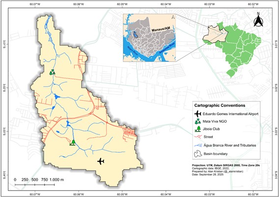
The Igarapé Água Branca basin, which covers approximately 5,965 km2, is a sub-basin of the Tarumã-Açu basin, a tributary of the Negro River (Figure 1). A growing alteration in the channel is observed due to real estate expansion and inadequate waste disposal, affecting its environmental quality and geomorphological characteristics (Pinho, 2022; Machado; Wachholz, 2023). These anthropogenic transformations directly affect the local fluvial dynamics, modifying surface runoff patterns, infiltration capacity, and the river's water level regime (Queiroz et al., 2024).

According to Queiroz et al., (2024), urban rivers in Manaus that flow into the Negro River exhibit two distinct patterns of seasonal variation in water level: in the middle and upper reaches, the level responds directly to precipitation, with peak flood levels coinciding with the rainiest period (March to April); in the lower reaches, near the mouth, the level is controlled by the oscillation of the Negro River, with a lag of two to three months between the peak of rainfall and the peak of flood.
The geomorphology of the region is characterized by small and medium-sized hills dissected by the action of the climate, closed valleys and a subdendritic drainage network, the area is modeled in the Alter do Chão Geological Formation. Locally, the altimetry of the region does not exceed 120 meters with hills with an altimetry between 50 and 100 meters (Vieira, 2008; Silva, 2005). Regarding the lithology of the basin, the Alter do Chão Formation predominates in the Manaus region, which is mainly composed of reddish sandstones, siltstones and mudstones, ranging from fine to medium, with cut and infill structures (Albuquerque, 1922; Caputo, 1984).
The soils in the region vary according to the topography. On the plateaus, Yellow Latosols predominate, associated with Spodosols and Plinthosols in undulating terrain. On the slopes, Red-Yellow Argisols stand out, while in the lower areas, hydromorphic Quartzarenic Neosols and Gleysols associated with alluvial plains occur (Radambrasil, 1978; Embrapa, 2018; Costa, 2020).
Methodological Procedures
Fieldwork in the basin was carried out on July 14, 2024, and August 2, 2024, during the low water period (Queiroz et al., 2020; 2024), and served as the basis for validating the hypsometry, slope, and land cover maps, as well as for analyzing the main channel (sinuosity, presence of debris, vegetation analysis, and analysis of fluvial units) and occurring anthropogenic actions (engineering works, effluent discharge, and solid waste).
The Digital Elevation Model (DEM) was obtained using FABDEM (Forest And Buildings removed Copernicus DEM) with a spatial resolution of 30 meters and removal of the influence of vegetation cover and anthropogenic constructions on the terrain (Hawker et al. 2022). The slope was calculated according to the classes defined by the Empresa Brasileira de Pesquisa Agropecuária (Brazilian Agricultural Research Corporation) (Embrapa, 1979) (Table 1).
Land use and land cover mapping was performed using PlanetScope Dove series images with daily revisits. The images have an approximate spatial resolution of 5 meters, covering swaths approximately 24 km wide. The mapping dates were defined as July 30, 2016, July 30, 2020, and June 10, 2024. The mapping was performed using the Semi-Automatic Plugin (SCP) in QGIS Desktop 3.40.5 software (QGIS Development Team, 2024). After automatic classification, post-processing was carried out with the Thematic Raster Editing (ThRasE) plugin, which allowed for the correction of classification errors common to this type of procedure. The classification accuracy was evaluated in SCP by comparing validation points with the classified image, showing values between 40% and 50%. The same procedure was applied after post-processing with the ThRasE plugin, resulting in accuracy greater than 95%.
RESULTS AND DISCUSSION
Analysis of the hypsometric distribution of the Água Branca River Basin indicates a predominant concentration in the intermediate altitude classes. Altitudes between 70 and 85 meters occupy the largest proportion of the area, corresponding to 33.01% (1.969 km2). Next, elevations between 55 and 70 meters represent 31.85% (1.9 km2), while the range from 40 to 55 meters covers 24.81% (1.48 km2). The lowest areas, between 25 and 40 meters, occupy 7.87% (0.47 km2), concentrating in the final runoff and main drainage zones. Finally, the highest altitudes, between 85 and 94 meters, represent 2.46% (0.146 km2) of the basin area (Figure 2).

A similar analysis carried out by Queiroz (2025) in the Mindu basin, where the altimetric variation between 119.66 m and 24.82 m, with an amplitude of 94.84 m and a relief ratio of only 0.005 m/km, also indicated a widely dissected terrain with reduced altitudinal variation. This behavior is comparable to that observed in the Água Branca River Basin, indicating that the urban basins of Manaus share a pattern of lowered relief.
Similarly, the results of this study were consistent with the analyses of Machado and Wachholz (2023), who, although they used a different methodology, identified a greater predominance of the 70 to 85 meter (32.42%) and 55 to 70 meter (31.71%) classes, followed by the intermediate altitudes of 40 to 55 meters (23.61%). The lowest elevations (25 to 40 m) and the highest areas (above 85 m) showed smaller proportions.
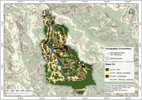
The analysis of the slope of the Água Branca River Basin, based on the FABDEM DEM, showed a predominance of flat classes (0 to 3%), which cover 45.89% (2.737 km2) of the total area. Next, the areas classified as gently undulating (3 to 8%) correspond to 41.81% (2.494 km2), while the undulating portions (8 to 20%) occupy 12.28% (0.733 km2). The areas with the greatest slope, grouped in the strongly undulating class (20 to 26%), are not very significant, representing only 0.02% (0.001 km2) of the basin (Figure 3).
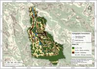
When compared to the results presented by Machado and Wachholz (2023), a significant difference is observed in the distribution of classes. While the authors identified a smaller proportion of flat areas (37.19%) and a more significant participation of the gently undulating (12.77%), undulating (24.84%) and mainly strongly undulating (20 to 45%) classes, with 21.32%, the current results point to a smoother relief configuration, with a concentration in the first two classes (flat and gently undulating), which together represent almost 88% of the basin area.
The difference between the results can be explained, above all, by the methodology adopted. While Machado and Wachholz (2023) derived the mapping from TIN (Triangular Irregular Network) contour line interpolation, a method that tends to accentuate local variations in relief and, consequently, increase the participation of classes with greater slope, the present study used the FABDEM model, which provides a more homogeneous altimetric representation and is corrected for artifacts associated with vegetation and anthropogenic constructions. This methodological distinction resulted in a smoother representation of the relief, with a predominance of flat and gently undulating classes.
According to Costa, Silva and Silva (2013), basins with low dissection and gently undulating relief tend to exhibit slow hydrological responses, with reduced flood peaks and greater morphological stability, which fits the pattern observed in the Água Branca River Basin. The reduced altimetric amplitudes, similar to those observed in the Tarumã-Açu and Puraquequara basins, reinforce the characterization of surfaces with little ruggedness, with a predominance of depositional processes. Colares et al., (2022) highlight that strongly undulating and steep areas represent a small fraction of the relief in the Manaus region, with gently undulating and undulating features predominating, a configuration that favors urban use but also the occurrence of localized erosive processes when vegetation is suppressed.
Human interventions such as earthworks and the deposition of clay materials tend to modify the natural structure and surface drainage, directly affecting water quality and altering the geomorphological balance of rivers. Therefore, the interpretation of altitudes and slopes should encompass not only the natural conditions of the relief, but also the modifications resulting from urban expansion and recent human interventions in the study area (Soares, 2025). This pattern shows a smoothed morphology, with a predominance of flat to gently undulating surfaces, resulting from a stabilized geomorphological dynamic.
Morphological Analysis of the Channel and Anthropogenic Alterations
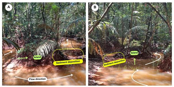
It was possible to observe, in the Água Branca River, the presence of small fluvial islands (Figure 4). These features were stabilized by perennial vegetation in fine sediments (silt + clay), similar to the islands that occur in the Negro River (Alves, 2013; Queiroz et al., 2025). On the banks of these islands, the deposition of sandy sediments is also observed, which may indicate an increase in the area of these islands due to the stabilization of sandbars (Leli, 2015).
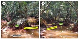
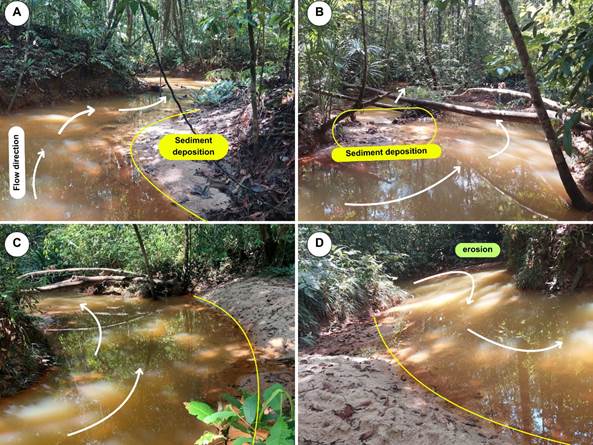
Figure 5 shows the dynamics of the current fluvial processes of the Água Branca River. In areas of curvature, sediment deposition is observed on the convex bank (Figures 5A and 5C), where the reduction in flow velocity favors the deposition of sandy material and fine sediments, resulting in the formation of bars. The presence of obstacles, such as fallen logs, also induces zones of low fluvial energy and localized deposition (Figure 5B). In contrast, concave banks show a higher concentration of flow energy, promoting lateral erosion and creating erosional banks that add sediments to the channel (Figure 5D). These processes are similar to what occurs in meandering rivers (Stevaux; Latrubesse, 2017).

Morphological features. A) Formation of sandbanks on the right bank of the Água Branca River. B) Sediment deposition on the left bank of the Água Branca River and its connection to the island in the middle of the riverbed. C) and D) Lateral erosion and deposition processes, with the formation of sandbanks (yellow line = limit of the deposits)
The middle reach of the Água Branca River shows a clear spatial organization of fluvial units, resulting from the interaction between the local slope and the exposure of the rocky substrate of the Alter do Chão Formation. The channel develops over a rocky bed, a common condition in urban rivers of Manaus (Queiroz et al., 2020), where surface erosion and natural dissection of the relief expose the consolidated material and control the local morphology.
In tropical rivers with rocky beds, the resistance of the lithologies and the geological structure control channel incision, limit lateral migration, and establish a more concentrated flow regime, characterized by stable channels and less morphological reactivity (Santos et al., 2022). The morphology of Amazonian riverbeds is strongly controlled by the interaction between flow and sediment transport, a process that defines bottom forms and patterns of deposition and erosion along the channel (Gualtieri et al., 2020). Thus, the morphodynamic behavior of the Água Branca River reflects this same lithological control, presenting a low-energy channel, but susceptible to rapid adjustments during intense precipitation events, due to the differential resistance of the substrate and the topographic configuration of the basin.
The Água Branca River Basin shows evidence of erosive and depositional processes intensified by urban expansion and inadequate management of stormwater runoff. Soil impermeabilization and the suppression of riparian vegetation have favored the increase in surface runoff and the input of sediments to the main channel, promoting the silting up of tributaries and the instability of slopes (Figure 6).

Anthropogenic actions on the right bank of the Água Branca River. A and B: Siltation of the channel, presence of damaged pipes/galleries draining from the avenue into the river. C) Area with evidence of burning. D) Emergence of the development amidst the vegetation on the banks of the Água Branca River
The advance of urbanization on the banks of an urban rivers in Manaus has generated similar conditions, with the accumulation of muddy materials and alteration of the natural dynamics of water discharge (Souza-Filho et al., 2019). Urban pressures on river basins intensify sediment input and compromise the natural morphodynamics of the channels. In Manaus, there is sewage contamination in the urban rivers (Mindu and Quarenta), showing that human activities contribute to the increase in the load of pollutants and sediments in aquatic environments (Melo et al., 2019).
Anthropogenic interventions such as dredging, canalization, and civil construction in floodplain areas have significantly modified the erosion, transport, and deposition processes in the urban rivers of Manaus, resulting in a new hydrosedimentary dynamic marked by the formation of technogenic deposits and the morphological instability of the channels (Queiroz et al., 2024).
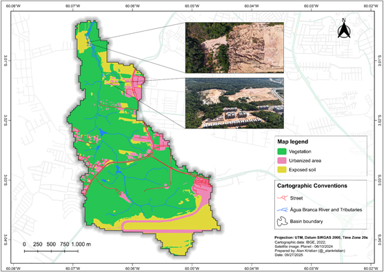
Thus, the situation observed in the Água Branca basin reflects a typical picture of urban fluvial degradation, in which the natural dynamics of the relief are replaced by a system conditioned by recent anthropogenic interventions. In this sense, one of the erosive features found in the Água Branca River Basin is a direct result of the removal of vegetation cover and intense urban occupation (Figure 7). It is a gully in an advanced stage, a common characteristic in Manaus, where the combination of lithology of the Alter do Chão Formation, high slope of the hillsides, and earthmoving processes associated with urban expansion intensify the susceptibility of the terrain to erosion.
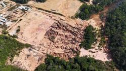
The occurrence of the gully identified in the lower reach of the basin confirms the vulnerability of the local relief to vegetation suppression and disorganized occupation, a recurring phenomenon in Manaus and also observed in municipalities in the metropolitan area (Vieira, 2008; Frota Filho et al., 2020; Vieira et al., 2022).
Studies indicate that the advance of these features is related to the sandy lithology of the Alter do Chão Formation, the steep slope, and the absence of adequate rainwater drainage, factors that favor concentrated surface runoff, the progressive retreat of headwaters, deforestation, and occupation of steep slopes. The costs exceed millions of reais in containment, relocation of families, and damage to the urban drainage network (Vieira, 2008; Molinari; Vieira, 2025). In addition to causing direct environmental impacts, such as soil loss and silting of channels, these features imply risks to infrastructure and the landscape. In this sense, the occurrence of gullies around the Água Branca River shows how urban erosive processes are associated with the natural morphology of the area, altering the hydro-sedimentological balance of the channel and conditioning the local fluvial dynamics.
The Negro River imposes a backwater effect on the Tarumã-Açu. This process is one of the main hydrodynamic controls on the flow regime and sedimentary processes in the lower reach of tributaries of the Amazon basin. This phenomenon occurs when the low slope of the channels, the large amplitude of water level variations and the difference in water discharge promote a strong influence of the main channel on the tributary, reducing the flow capacity and generating subcritical flow zones and low energy, so that the lower reach of the channels becomes conducive to sediment deposition (Siqueira; Filizola, 2021). The Água Branca Rivers subject to the backwater effect of the Tarumã Açú River, thus the lower reach has its valley blocked and the channel begins to respond to the fluvial regime of the Negro River (Figure 8).
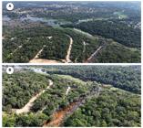
Mouth of the Água Branca River at its confluence with the Tarumã-Açu River. (A) General view of the confluence, highlighting the Bolívia, Tarumã-Açu and Água Branca Rivers; (B) Detail of the Água Branca River near its mouth, showing the influence of the backwater Effect
Land Use and Land Cover
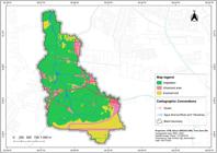
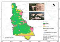
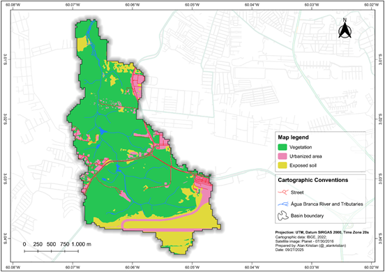
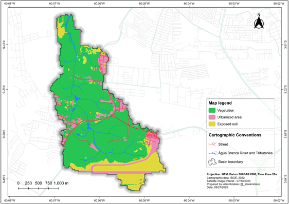
The analysis of land cover dynamics between 2016 and 2024 reveals gradual changes in land use and occupation in the study area. Natural vegetation, which represented 71.9% of the surface in 2016 (4,287 km2), showed a slight increase in 2020, reaching 72.7% (4,335 km2), followed by a moderate reduction in 2024, when it occupied 68.3% (4,073 km2). This recent decrease indicates a trend of progressive conversion of vegetation cover, possibly associated with urban expansion and the advance of areas under anthropogenic use.
Urbanized areas showed continuous and gradual growth throughout the analyzed period, increasing from 11.5% (0.685 km2) in 2016 to 13.3% (0.794 km2) in 2024. Similarly, exposed soil varied from 16.6% (0.993 km2) in 2016 to 18.4% (1.098 km2) in 2024, after a punctual decrease in 2020 (15.5%). These results indicate a progressive process of intensification of anthropogenic use and reorganization of land cover. (Table 2).
In 2016 (Figure 9), vegetation covered most of the basin, creating a relatively preserved landscape, with urbanized areas restricted to the vicinity of Eduardo Gomes International Airport and some older settlements. Exposed soil appeared sporadically, mainly associated with earthmoving works and the surroundings of urbanized areas. In 2020 (Figure 10), the intensification of the urban expansion process is observed, with a significant increase in built-up areas. Exposed soil increased proportionally, becoming more diffusely distributed throughout the basin, especially in areas of real estate expansion and road corridors. Despite this, vegetation remained the predominant class, although it was receding in the face of anthropogenic advance.
In 2024 (Figure 11), the peak of the spatial transformation recorded in this time series is observed. Urbanized areas increased significantly, occupying middle and lower sectors of the basin, with emphasis on the growth of subdivisions and residential condominiums. The exposed soil also showed increases, a result of continuous deforestation and the opening of new areas for construction and urban expansion. In this context, vegetation remains the predominant class, but its reduction is visible compared to previous years.

The results of this study corroborate previous investigations that address the transformations in land use and land cover in the Manaus region. The predominance of natural vegetation areas (approximately 76%), accompanied by the progressive expansion of anthropic surfaces, especially built-up areas and exposed soil in the Água Branca River (Machado; Wachholz, 2023). Although different methodologies have been applied, there is convergence regarding the regional trend of replacing vegetation cover with anthropized surfaces, a phenomenon directly associated with the advance of urbanization in the basin. The population growth of Manaus has always been linked to waterways, so that irregular occupations on the riverbanks are frequent in the Manaus landscape. This model reflects the economic development driven by the Manaus Free Trade Zone and the considerable increase in the city's population after the implementation of the industrial hub (Oliveira, 2008).
Unplanned urban expansion in the Tarumã-Açu river basin, where the Água Branca River Basin is located, has caused significant environmental impacts, including erosion, aggravated by the lack of sanitation infrastructure and the irregular occupation of permanent preservation areas (Santos, 2024) and degradation of water quality (Machado; Wachholz, 2025). Therefore, considering the set of regional analyses, it is observed that the pattern identified in the Água Branca River Basin is part of a broader trend of urban expansion in the western zone of Manaus, marked by the gradual replacement of vegetation with impermeable areas, environmental fragmentation, and the loss of the hydrological functionality of the basins. These transformations reinforce the need for urban planning and management strategies that consider the ecological limits of the micro-basins and the importance of vegetation cover for maintaining water flows and soil stability.
CONCLUSION
The analyses carried out in the Água Branca River Basin showed that the geomorphological configuration, marked by intermediate altitudes and a predominance of flat and gently undulating slopes, plays an important role in the local hydrosedimentary dynamics. The results demonstrated that urban expansion and the suppression of riparian vegetation have caused significant changes in the morphology and stability of the channel, intensifying erosive and depositional processes that directly affect the environmental quality of the basin.
The integration between morphological analysis and the anthropogeomorphological perspective allowed for a broader understanding of the interactions between natural and anthropogenic factors, highlighting the role of urbanization in the reconfiguration of the Amazonian fluvial landscape. This approach contributes to the understanding of the dynamics of the urban micro basins of Manaus, while reinforcing the need to incorporate geomorphological and environmental criteria in territorial planning and public policies aimed at mitigating urban impacts. For future work, continuous monitoring of the basin is recommended using longer time series and including hydrological and water quality variables, in order to deepen the analysis of the effects of anthropogenic transformations and support environmental management strategies. In this way, the research reaffirms the importance of integrating geomorphological knowledge into urban planning actions, contributing to the conservation of Amazonian urban basins and to the balance between human occupation and the preservation of river systems.
It reinforces the need for the management of the Água Branca River Basin to be accompanied by integrated planning and monitoring actions, involving bodies such as the Instituto de Proteção Ambiental do Amazonas (IPAAM), the Secretaria Municipal de Meio Ambiente e Sustentabilidade (SEMMAS), as well as partnerships with universities and community organizations. Such initiatives should prioritize the recovery of degraded areas, the protection of riparian forests, and the prevention of fluvial processes influenced by anthropogenic activity. Among the recommended measures, the following stand out: mapping of risk areas, identification of sources of degradation, and continuous monitoring of environmental quality, ensuring that urban expansion occurs in a way that has the least impact on water resources and the geomorphological dynamics of the basin.
ACKNOWLEDGEMENTS
The authors acknowledge the Universidade do Estado do Amazonas (UEA), where this research was conducted, as well as the Universidade Federal do Amazonas (UFAM) and the Universidade Federal de Rondônia (UNIR) for their institutional and scientific support. The authors also thank the Fundação de Amparo à Pesquisa do Estado do Amazonas (FAPEAM) for the financial support provided through a research fellowship. Finally, the authors acknowledge the Laboratório de Cartografia e Geotecnologias of the Universidade do Estado do Amazonas (LabCGEO/UEA) for the technical support and infrastructure made available.
DATA AVAILABILITY
The data that support the findings of this study can be made available, upon reasonable request, from the corresponding author [Alan Kristian Nunes Machado].
References
- ALBUQUERQUE, O. Reconhecimentos geológicos no vale do Amazonas. Boletim do Serviço Geológico e Mineralógico do Brasil, v. 3, p. 84, 1922.
-
ALVES, A. C.; FREITAS, I. S.; SANTOS, M. Q. Análise multitemporal da expansão urbana da cidade de Manaus, Amazonas, utilizando imagens de satélite. Geosaberes: Revista de Estudos Geoeducacionais, v. 11, n. 1, p. 305-317, 2020. https://doi.org/10.26895/geosaberes.v11i0.802
» https://doi.org/10.26895/geosaberes.v11i0.802 - ALVES, N. S. Mapeamento Hidromorfodinâmico do Complexo Fluvial de Anavilhanas: Contribuição aos Estudos de Geomorfologia Fluvial de Rios Amazônicos. 2013. Tese (Doutorado em Geografia) - Universidade de São Paulo, São Paulo, 2013.
-
ANTONIO, I. C. Índices climáticos e caracterização climática no entorno de Manaus. Revista Brasileira de Geografia Física, v. 10, n. 4, p. 1120-1133, 2017. https://doi.org/10.26848/rbgf.v10.4.p1120-1133
» https://doi.org/10.26848/rbgf.v10.4.p1120-1133 - CAPUTO, M. V. Stratigraphy, tectonics, paleoclimatology and paleogeography of northern basins of Brazil. 1984. 583 f. PhD Thesis (Doctor of Philosophy) - University of California, Santa Barbara, 1984.
- CARVALHO, A. S.; NOGUEIRA, A. C. R.; FERNANDES FILHO, L. A.; NOGUEIRA, A. C. R. A Geologia da região de Manaus. In: Simpósio de Geologia da Amazônia, 8., 2003, Manaus, Anais [...], Manaus: SBG/Núcleo Norte, 2003.
-
COLARES, I. S.; FERREIRA JUNIOR, J. C.; RODRIGUES, L. S.; MAIA, S. A.; WACHHOLZ, F. Suscetibilidade do solo à erosão na bacia hidrográfica do Rio Tarumã-Açu (Amazonas- Brasil). Caminhos de Geografia, v. 23, n. 89, p. 367-389, 2022. https://doi.org/10.14393/RCG238960655
» https://doi.org/10.14393/RCG238960655 -
COSTA, E. B. S.; SILVA, C. L.; SILVA, M. L. Caracterização física das Bacias Hidrográficas na região de Manaus (AM). Caminhos da Geografia: Uberlândia, v. 14, n. 46, 2013. p. 93-100. https://doi.org/10.14393/RCG144619846
» https://doi.org/10.14393/RCG144619846 - COSTA, J. S. Relatório de situação bacia hidrográfica do Tarumã-Açu (Livro eletrônico): Transformações antrópicas e qualidade da água. 1. ed. Manaus: Ed. do autor, 2020.
- COUCEIRO, S. R. M. Efeitos do desmatamento e da poluição sobre a riqueza, densidade e composição de macroinvertebrados aquáticos de igarapés urbanos de Manaus, Amazonas. 2005. Dissertação (Programa em Ciências Biológicas) - Instituto Nacional de Pesquisas da Amazônia - INPA, Manaus, 2005.
-
EMBRAPA - Empresa Brasileira de Pesquisa Agropecuária. Serviço Nacional de Levantamento e Conservação de Solos (Rio de Janeiro, RJ). Súmula da 10. Reunião Técnica de Levantamento de Solos. Rio de Janeiro, 1979. 83p. Disponível em: https://www.infoteca.cnptia.embrapa.br/infoteca/handle/doc/327212 Acesso em: 8 out. 2025.
» https://www.infoteca.cnptia.embrapa.br/infoteca/handle/doc/327212 -
EMBRAPA - Empresa Brasileira de Pesquisa Agropecuária. 5. ed. rev. e ampl. Brasília, DF: Embrapa, 2018. 356 p. Disponível em: https://www.infoteca.cnptia.embrapa.br/infoteca/handle/doc/1094003 Acesso em: 15 fev. 2026.
» https://www.infoteca.cnptia.embrapa.br/infoteca/handle/doc/1094003 -
FROTA FILHO, A. B.; ABREU, N. R. P.; VIEIRA, A. F. S. G. Processo de voçorocamento e feições secundárias: um estudo de caso em Manaus-AM. Caminhos de Geografia, v. 21, n. 74, p. 313-323, 2020. https://doi.org/10.14393/RCG217441778
» https://doi.org/10.14393/RCG217441778 -
GUALTIERI, C.; MARTONE, I.; FILIZOLA, N.; IANNIRUBERTO, M. Bedform morphology in the area of the confluence of the Negro and Solimões-Amazon rivers, Brazil. Water, v. 12, n. 6, p. 1630, 2020. https://doi.org/10.3390/w12061630
» https://doi.org/10.3390/w12061630 -
HAWKER, L.; UHE, P.; PAULO, L.; SOSA, J.; SAVAGE, J.; SAMPSON, C.; NEAL, J. A 30 M global map of elevation with forests and buildings removed. Environmental Research Letters, v. 17, n. 2, p. 024016, 2022. https://doi.org/10.1088/1748-9326/ac4d4f
» https://doi.org/10.1088/1748-9326/ac4d4f - LELI, I. T. Gênese, evolução e geomorfologia das ilhas e planície de inundação do alto Rio Paraná, Brasil. 2015. Tese (Doutorado em Geociências e Meio Ambiente) - Instituto de Geociências e Ciências Exatas, Universidade Estadual Paulista, Rio Claro, 2015.
-
MACENA, L. S. L.; COSTA, R. C. A cidade como espaço do risco: estudo em bacias hidrográficas de Manaus, Amazonas - BR. Revista Geonorte, Manaus, Edição Especial, v. 3, 1(4), p. 318-330, 2012. Disponível em: https://www.periodicos.ufam.edu.br/index.php/revista-geonorte/article/view/1829 Acesso em: 15 nov. 2025.
» https://www.periodicos.ufam.edu.br/index.php/revista-geonorte/article/view/1829 -
MACHADO, A. K. N.; WACHHOLZ, F. Análise das ações antrópicas e mapeamento da Bacia Hidrográfica do Igarapé Água Branca, Manaus/AM. In: Anais do XX Simpósio Brasileiro de Sensoriamento Remoto, 2023, Florianópolis. Anais eletrônicos. São José dos Campos, INPE, 2023. Disponível em: https://proceedings.science/sbsr-2023/trabalhos/analise-das-acoes-antropicas-e-mapeamento-da-bacia-hidrografica-do-igarape-agua?lang=pt-br Acesso em: 15 out. 2025.
» https://proceedings.science/sbsr-2023/trabalhos/analise-das-acoes-antropicas-e-mapeamento-da-bacia-hidrografica-do-igarape-agua?lang=pt-br -
MACHADO, A. K. N; WACHHOLZ, F. Avaliação dos impactos antrópicos na água do igarapé Água Branca, Manaus/AM. Revista Geonorte, Manaus, v. 16, n. 55, p. 368-393, 2025. https://doi.org/10.21170/geonorte.2025.V.16.N.55.368.393.
» https://doi.org/10.21170/geonorte.2025.V.16.N.55.368.393 -
MARINHO, R. R.; FURTADO, A. R.; SANTOS, V. C.; ZUMAK, A.; FILIZOLA, N. P. Riverbed morphology and hydrodynamics in the confluence of complex mega rivers -A study in the Branco and Negro rivers, Amazon basin. Journal of South American Earth Sciences, v. 118, p. 103969, 2022. https://doi.org/10.1016/j.jsames.2022.103969
» https://doi.org/10.1016/j.jsames.2022.103969 -
MELO, M. G.; SILVA, B. A.; COSTA, G. S.; NETO, J. C. A. S.; SOARES, P. K.; VAL, A. L.; CHAAR, J. S.; KOOLEN, H. H. F.; BATAGLION, G. A. Sewage contamination of Amazon streams crossing Manaus (Brazil) by sterol biomarkers. Environmental Pollution, v. 244, p. 818-826, 2019. https://doi.org/10.1016/j.envpol.2018.10.055
» https://doi.org/10.1016/j.envpol.2018.10.055 -
MOLINARI, D. C. Áreas de risco a voçorocamento em Manaus/AM: Uma contribuição à Geografia Ambiental. Ambientes: Revista de Geografia e Ecologia Política, v. 4, n. 2, p. 15-70, 2022. https://doi.org/10.48075/amb.v4i2.30322
» https://doi.org/10.48075/amb.v4i2.30322 - MOLINARI, D. C. Intervenções públicas em áreas de risco avoçorocamento na cidade de Manaus (AM). Revista Verde Grande: Geografia e Interdisciplinaridade, v. 6, n. 01, p. 4-30, 2024. https://doi.org/10.46551/rvg26752395202410430
-
MOLINARI, D. C.; VIEIRA, A. F. S. G. Obras de recuperação de áreas de risco a voçorocamento em Manaus (AM): caracterização e limitações. Revista da ANPEGE, v. 21, n. 45, 2025. https://doi.org/10.5418/ra2025.v21i45.19868
» https://doi.org/10.5418/ra2025.v21i45.19868 - OLIVEIRA, J. A. Espaço-Tempo De Manaus: a natureza das águas na produção do espaço urbano. Espaço E Cultura, UERJ, RJ, N. 23, P. 33-41, 2008.
-
PINHO, J. ÁGUA BRANCA: saiba mais sobre a última nascente viva de igarapé em manaus e sua importância. Saiba mais sobre a última nascente viva de igarapé em Manaus e sua importância. 2022. Disponível em: https://portalamazonia.com/meio-ambiente/agua-branca-saiba-mais-sobre-a-ultima-nascente-viva-de-igarape-em-manaus-e-sua-importancia/ Acesso em: 26 out. 2025.
» https://portalamazonia.com/meio-ambiente/agua-branca-saiba-mais-sobre-a-ultima-nascente-viva-de-igarape-em-manaus-e-sua-importancia/ -
PINTO, A. G. N.; HORBE, A. M. C.; SILVA, M. S. R.; MIRANDA, S. A. F.; PASCOALOTO, D.; SANTOS, H. M. C. Efeitos da ação antrópica sobre a hidrogeoquímica do rio Negro na orla de Manaus, AM. Acta amazônica, Manaus, v. 39, n. 3. p. 627-638, set. 2009. https://doi.org/10.1590/S0044-59672009000300018
» https://doi.org/10.1590/S0044-59672009000300018 -
QGIS DEVELOPMENT TEAM. 2024. QGIS Geographic Information System. Version 3.40.5. Open Source Geospatial Foundation. Disponível em: https://qgis.org/ Acesso em: 10 mar. 2026.
» https://qgis.org/ -
QUEIROZ, M. S. Análise morfométrica da Bacia Hidrográfica do Mindu, Manaus, Amazonas. Revista Verde Grande: Geografia e Interdisciplinaridade, v. 7, n. 01, p. 581-597, 2025a. https://doi.org/10.46551/rvg2675239520251581597
» https://doi.org/10.46551/rvg2675239520251581597 -
QUEIROZ, M. S.; ALVES, N. S. Análise Geomorfométrica da Bacia Hidrográfica do Mindu-Manaus-Amazonas. Geopauta, v. 4, n. 2, p. 109-123, 2020. https://doi.org/10.22481/rg.v4i2.6438
» https://doi.org/10.22481/rg.v4i2.6438 -
QUEIROZ, M. S.; BATISTA, S. P. M.; ALVES, N. S. Análise Hidrológica do Igarapé do Mindu, Manaus, Amazonas, Brasil. Revista da Casa da Geografia de Sobral (RCGS), [S. l.], v. 22, n. 3, p. 57-71, 2020. https://doi.org/10.35701/rcgs.v22n3.704
» https://doi.org/10.35701/rcgs.v22n3.704 -
QUEIROZ, M. S.; BATISTA, S. P. M.; ALVES, N. S.; MARINHO, R. R. Antropoceno: A Influência Antrópica nos Processos Fluviais de Rios Urbanos. Geoambiente On-line, Goiânia, n. 49, 2024. Disponível em: https://revistas.ufj.edu.br/geoambiente/article/view/76855 Acesso em: 29 set. 2025.
» https://revistas.ufj.edu.br/geoambiente/article/view/76855 -
QUEIROZ, M. S.; MARINHO, R. R.; CARVALHO, J. A. L.; SILVA, C. F. The geomorphological landscape of the Mariuá Archipelago: An anabranching megacomplex system in the Negro River, Amazon Basin (Brazil). Geomorphology, 490, 110023, 2025b. https://doi.org/10.1016/j.geomorph.2025.110023
» https://doi.org/10.1016/j.geomorph.2025.110023 -
RADAMBRASIL. Geologia, geomorfologia, pedologia, vegetação e uso potencial da terra. Departamento Nacional de Produção Mineral, Vol. 1-34. Brasília, Distrito Federal. 1978. Disponível em: https://biblioteca.ibge.gov.br/biblioteca-catalogo.html?view=detalhes&id=281395 Acesso em: 09 out. 2025.
» https://biblioteca.ibge.gov.br/biblioteca-catalogo.html?view=detalhes&id=281395 - SANTOS, S. N. Dinâmica espaço-temporal do uso e cobertura da terra e seus reflexos sobre a qualidade da água da bacia no rio Tarumã-Açu. 2024. Dissertação (Mestrado em Geografia) - Universidade Federal do Amazonas, Manaus, 2024.
-
SANTOS, V.; STEVAUX, J. C.; SZUPIANY, R. N. Confluence analysis at basin scale in a tropical bedrock river-The Ivaí River, Southern Brazil. Journal of South American Earth Sciences, v. 116, p. 103877, 2022. https://doi.org/10.1016/j.jsames.2022.103877
» https://doi.org/10.1016/j.jsames.2022.103877 - SILVA, C.L. Análise Da Tectônica Cenozóica Da Região De Manaus E Adjacências. Tese (Programa de Pós-Graduação em Geociências) - Universidade Estadual Paulista, Rio Claro, 2005.
-
SIOLI, H. Tropical Rivers as Expressions of Their Terrestrial Environments. Tropical Ecological Systems, Berlin, v. 11, p. 275-288. 1975. Springer Berlin Heidelberg. https://doi.org/10.1007/978-3-642-88533-4_19
» https://doi.org/10.1007/978-3-642-88533-4_19 -
SIQUEIRA, L. F.; FILIZOLA, N. Estudo hidrológico do efeito de barramento hidráulico no rio Tarumã-Açu, Manaus-AM. Revista Brasileira de Geomorfologia, v. 22, n. 2, p. 315-335, 2021. https://doi.org/10.20502/rbg.v22i2.1752
» https://doi.org/10.20502/rbg.v22i2.1752 - SOARES, B. S. Monitoramento da qualidade da água e do uso e cobertura da terra na Cachoeira Alta do Tarumã, Manaus/AM. 2025. Dissertação (Mestrado em Geografia) - Universidade Federal do Amazonas, Manaus, 2025.
-
SOUZA-FILHO, E. A.; HORTÊNCIO-BATISTA, I.; ALBUQUERQUE, C. C. Levantamento de aspectos físico-químicos das águas da microbacia do mindu em Manaus-Amazonas. Revista Geográfica de América Central, n. 63, p. 295-321, 2019. http://dx.doi.org/10.15359/rgac.63-2.13.
» https://doi.org/10.15359/rgac.63-2.13 - STEVAUX, J. C.; LATRUBESSE, M. E. Geomorfologia Fluvial. Oficina de Textos: São Paulo: 2017.
- SUGUIO, K.; BIGARELLA, J. J. Ambientes de sedimentação: sua interpretação e importância - Ambiente fluvial. Curitiba: Editora da Universidade Federal do Paraná; Associação de Defesa e Educação Ambiental ADEA, 1979.
- VIEIRA, A. F. S. G. Desenvolvimento e distribuição de voçorocas em Manaus (AM): principais fatores controladores e impactos urbano-ambientais. 2008. 310 f. Tese (Doutorado em Geografia) - Universidade Federal de Santa Catarina, Florianópolis, 2008.
-
VIEIRA, A. F. S. G.; LIMA, C. M. R.; SILVA, G. M. Caracterização das voçorocas da área urbana de Rio Preto da Eva (AM), Norte do Brasil. Geologia USP, Série Científica, v. 22, n. 4, p. 95-107, 2022. https://doi.org/10.11606/issn.2316-9095.v22-195101
» https://doi.org/10.11606/issn.2316-9095.v22-195101

 Source: The authors (2025).
 Source: The authors (2025).
 Source: The authors (2025).
 Source: The authors (2024).
 Source: The authors (2024).
 Source: The authors (2024).
 Source: The authors (2024).
 Source: The authors (2024).
 Source: The authors (2025).
 Source: The authors (2025).
 Source: The authors (2025).