
 Territoriality and Heritage in Ibiraquera: Social Cartography of an Azorian Community
Abstract
Coastal artisanal fishing communities possess an invaluable historical, cultural, and natural heritage, whose relationship with their traditional territories is not evident. Established from generation to generation, they carry with them a rich historical and cultural heritage, as well as integrating important natural features. By addressing the question "How does historical, cultural, and natural heritage express a sense of territoriality for Azorean coastal communities established in southern Brazil?", this research seeks to relate the territory to the people who live there. Thus, data were collected in the community of Ibiraquera, located on the coast of the south-central region of the state of Santa Catarina, through: (i) guided visits to record points of importance and stories; (ii) semi-structured interviews; and (iii) meetings to construct social cartography. Participants were selected using the snowball method, with Quantum Gis (QGIS) software used to create maps. By prioritizing knowledge construction from a popular, symbolic, and cultural perspective, social cartography is a participatory research method in which social actors express their territorialities, desires, and ancestry. Fishing ranches, flour mills, traditional paths, cultural events, and points of historical importance were highlighted as historical, cultural, and natural heritage sites. These assets demonstrated an intrinsic connection between the community and its traditional territories, encompassing both tangible and intangible aspects. Engagement with space, over generations and through its use and appropriation, has provided a sense of territoriality to this traditional population that is closely linked to its heritage.
Keywords:
Traditional communities; Participatory mapping; Coastal zone
Resumo
As comunidades de pescadores artesanais costeiros possuem um patrimônio histórico-cultural e natural inestimável, cujas relações com seus territórios tradicionais não são evidentes. Ao serem estabelecidas de geração para geração, carregam consigo uma rica carga histórica e cultural, além de integrarem aspectos naturais importantes. Ao abordar a questão “Como o patrimônio histórico, cultural e natural expressa um senso de territorialidade para as comunidades costeiras açorianas estabelecidas no sul do Brasil?”, esta pesquisa busca relacionar o território com as pessoas que ali vivem. Desta forma, os dados foram coletados na comunidade de Ibiraquera, localizada no litoral da região centro-sul do Estado de Santa Catarina, por meio de: (i) visitas guiadas para registro de pontos de importância e histórias; (ii) entrevistas semiestruturadas e; (iii) reuniões para construção da cartografia social. A seleção dos participantes foi realizada pelo método bola de neve, utilizando o software Quantum Gis (QGIS) para criação dos mapas. Ao privilegiar a construção do conhecimento sob a perspectiva popular, simbólica e cultural, a cartografia social constitui um método de pesquisa participativa onde os atores sociais expressam suas territorialidades, desejos e ancestralidades. Os ranchos de pesca, engenhos de farinha, caminhos tradicionais, manifestações culturais e pontos de importância históricos foram destacados como patrimônios histórico-cultural e natural. Estes patrimônios demonstraram uma conexão intrínseca entre a comunidade e seus territórios tradicionais, abrangendo aspectos materiais e imateriais. O envolvimento com o espaço, ao longo das gerações e através do seu uso e apropriação, forneceu um senso de territorialidade a esta população tradicional que está intimamente vinculada aos seus patrimônios.
Palavras-chave:
Comunidades tradicionais; Mapeamento participativo; Zona costeira
INTRODUCTION
The relationships between historical, cultural, and natural heritage can be established based on definitions that consider space as a starting point. To Scifoni (2006a), the concept of natural heritage has two approaches: the first concerns nature that is untouched or little used by humans, and the second integrates social memory, mainly regarding landscapes modified by cultural action. Historical heritage can be understood as a language that transmits and strengthens everyday relationships by affirming elements of social identity (Feiber, 2007), through the mediation of social and historical knowledge. Aiming to form a social identity, the preservation of historical heritage must go beyond the past museumification, leading communities to exercise a sense of citizenship over identified heritage sites.
According to Tempass (2006), cultural heritage values, beyond material aspects, the intangible properties of human relationships with space:
“The construction of the concept of heritage focuses on the discussion between the nation, national identity, and territoriality. Thus, identity and territoriality are two fundamental requirements for defining cultural references, which in turn are necessary for broader concepts of tangible and intangible cultural heritage.”
In Brazil, Decree 6.040/2007 establishes a policy for traditional peoples and communities based on their distinct cultural characteristics, self-recognition, and appropriation of space and natural resources (Brasil, 2007). Traditional fishing communities play a fundamental role in the conservation of cultural, historical, social, and biodiversity management values.
According to Conceição et al. (2020), artisanal fishing practices are learned through family life and direct contact with nature, and are used for socioeconomic reproduction, with a way of life that includes plant extraction, handicrafts, and family farming. Consequently, traditional knowledge is part of the way of life of these populations, who create strategies and references based on their own interpretations of the world (Castillo et al., 2023).
This acquired knowledge encompasses aspects that are part of their tangible and intangible heritage, as they are embedded in their living spaces. Fishing territories can be understood as spaces used and appropriated by the descendants of Azoreans who, through their productive and social activities, demonstrate the socioeconomic, environmental, and cultural importance of the place (Rios, 2015). As they carry out their activities, establish power relations, and demarcate their territory, these subjects lead to a conceptualization of territory:
[...] outlined by the groups themselves according to their specific identities. Tradition, often evoked in the definition of these identities, will appear, however, as a way of being in the present itself. Traditional is defined as the mode of occupation of the territory and not the duration of that occupation (Junior, 2010, p. 5).
Similarly, Social Cartography is a tool that prioritizes the construction of popular, symbolic, and cultural knowledge developed under the precepts of collectivity, where different social groups express their aspirations and desires (Gorayeb et al., 2015). Using maps to express social concerns is a way of organizing politically in territories (Junior, 2010). In this sense, the concept of “territory” is a key part of work involving social cartography (Costa et al., 2016). Participatory mapping methods combined with geoprocessing technologies such as GIS (Geographic Information Systems) and GPS (Global Positioning System) have been adopted, broadening the horizon of spatial representation production and instrumentalization (Freitas; Nunes, 2020).
Linked to social transformation, these tools are used for participatory action research and community development (Landim Neto et al., 2013). The mapping goes beyond physical aspects, moving towards social concepts such as environmental problems, conflict situations, school transportation, work, leisure, life history, and others (Lima; Costa, 2012), seeking to highlight the political and social reproduction content expressed in the maps.
In this way, maps can be incorporated into social struggles, highlighting ethnic, religious, and gender factors, which are related to the constitutional guarantee of territorial rights (Costa et al., 2016). This research seeks to answer the following question: How does historical, cultural, and natural heritage express a sense of territoriality for Azorean coastal communities established in southern Brazil? The objective of this article was to understand the relationship between a coastal community in south-central Santa Catarina (Brazil) and its traditional territories and historical, cultural, and natural heritage.
METHODOLOGY
Study Area
Of indigenous cultural origin from the Tupi-Guarani ethnic group: IBIRA (tree), QUÉ (here) and RA (spoon) have their own name as heritage (Ibiraquera) (Avellar, 1993). The first families to settle in the region in the mid-1880s were the Teixeira, Silveira, and Souza families, the first two originating from Imbituba and the last from Garopaba (Avellar, 1993). The traditional community does not depend exclusively on fishing, but also engages in other economic activities within its territory, such as construction and tourism.
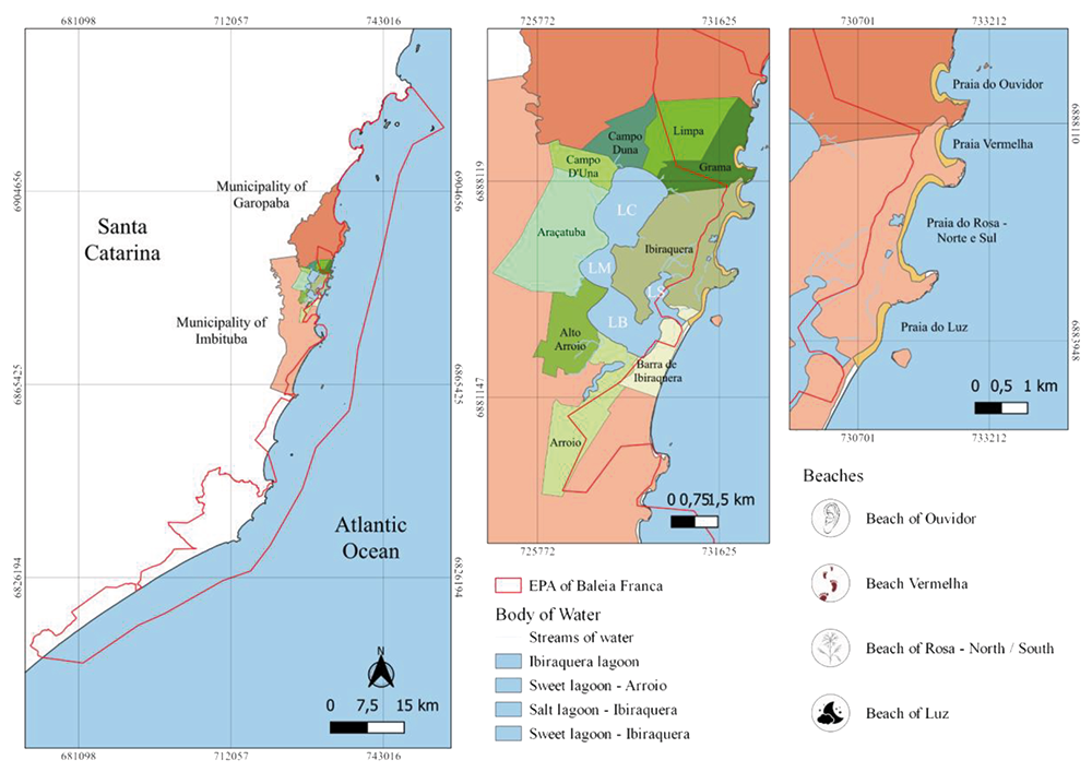
The Ibiraquera Lagoon is located on the coast of the south-central region of the state of Santa Catarina, with most of it located in the municipality of Imbituba and, to a lesser extent, in the municipality of Garopaba (Figure 1). As a micro-watershed, its geomorphological structure is subdivided into four sectors: Lagoa de Cima (LC), Lagoa do Meio (LM), Lagoa de Baixo (LB) and Lagoa do Saco (LS), covering a total area of approximately 7.9 km². The Ibiraquera bar, which flows into the sea, is intermittent, meaning that it is normally opened artificially, while it is closed by the action of the tides (Netto, 2018).
In addition, this part of the southern coast of Santa Catarina is home to the Environmental Protection Area (EPA) of Right Whale, a Sustainable Use Protected Area created in 2000. Only the Ibiraquera Lagoon bar and the coastal areas of the region are part of this conservation area.
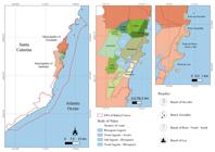
Location of communities surrounding Ibiraquera Lagoon, in the municipalities of Imbituba and Garopaba, Santa Catarina, Brazil (LC: Lagoa de Cima; LM: Lagoa do Meio; LB: Lagoa de Baixo and LS: Lagoa do Saco)
Regionally, until the 1960s, Ibiraquera Lagoon was sparsely populated, mainly by fishing families who, in addition to fishing, practiced subsistence agriculture. In the 1970s, as economic development took place in the area, with the introduction of services (electricity) and the opening of roads, the region began to gain recognition, attracting new residents and tourists. However, it was from the 1990s onwards that tourism and urbanization began to grow more rapidly, leading to changes in the environment, such as the development of housing estates (Feijó, 2021).
Marine and marine-estuarine fishery resources are predominantly found in Ibiraquera Lagoon, with around 30 species already inventoried (Netto, 2018). The fresh water in the lagoon comes from rainfall and small streams that flow into it. Thus, among the uses of the lagoon and the neighborhood, tourist and recreational activities, ecotourism, fishing, aquaculture, and agriculture can be highlighted, with the main sector being services, which includes civil construction. The location attracts people and companies from the tourism, hotel, gastronomy, and sports sectors, which has resulted in increased occupancy in the area surrounding the lagoon.
Due to the region's tourism potential, these locations are threatened by environmental impacts resulting from disorderly land use and occupation, inefficient urban drainage systems, inadequate solid waste disposal, vegetation removal (De Freitas; Beltrame, 2012), illegal discharge of effluents, silting, and poorly designed septic tanks (Cohenca et al., 2017; De Freitas et al., 2022).
Data Collection and Analysis
The data were collected in three simultaneous stages, with an emphasis on ethnographic recording techniques of knowledge about their individual and common spaces, through: (i) guided tours to record points of importance and stories; (ii) semi-structured interviews; (iii) meetings to construct social cartography. Participants were selected using the snowball method (Bernard, 2006). The initial group of actors approached was identified through community leaders, who suggested names of potential research subjects. Participants were selected based on the following criteria: (i) fishing is their main source of income; (ii) they have lived in the community for more than 15 years; and (iii) they are descendants of the oldest families in the region. To maintain anonymity and protect the privacy of those interviewed, fictitious names were assigned to the quotes in the testimonies.
In total, there were four guided tours consisting of traveling with community members along traditional paths using equipment to record detailed information, such as GPS, voice recorders, and cameras. GPS mapping of fishing routes, historical sites, and places of importance to the community were used to georeferenced this data (Chart 1). In the second stage, the data was entered into a standard general map containing only the previously mapped routes, marking the start of the meetings to produce the social cartography maps. Six meetings were held at ASPECI's premises and in some homes, bringing together community leaders and descendants of Azoreans from the region.
During the meetings, in addition to the locations previously mapped with georeferenced data, fishing camps, mills, and areas of importance were also identified using satellite images. In addition, seven semi-structured interviews were conducted with the same participants, guided by leading questions, which sought to record specific topics, such as older experiences in the territory, as well as to deepen the accounts already mapped, through audio recordings, investigating different perspectives and points of view. The research was approved by the Human Research Ethics Committee of UniSul (CAAE: 44557221.0.0000.5369).
Since these meetings took place according to their availability for conversations outside of their working hours. The recorded audio files were transcribed and the data organized based on the identification of historical, cultural, and natural heritage. The meetings served as opportunities for discussion and for highlighting social, economic, environmental, and political issues whose cartographic representation is of interest to the community (Costa et al., 2016). The information was validated throughout the data collection phase. The open-source Geographic Information System (GIS), Quantum GIS (QGIS, 2023), was used to structure the maps, based on satellite images obtained from Google Earth (GOOGLE, 2023), the database made available by the Instituto Brasileiro de Geografia e Estatística (IBGE, 2022) (Brazilian Institute of Geography and Statistics) in 2022, and data collected from GPS. The analyses were performed by superimposing layers and integrated visualization of the territory.
APPROACHES TO THE HISTORICAL, CULTURAL, AND NATURAL HERITAGE AND TERRITORIALITY OF IBIRAQUERA
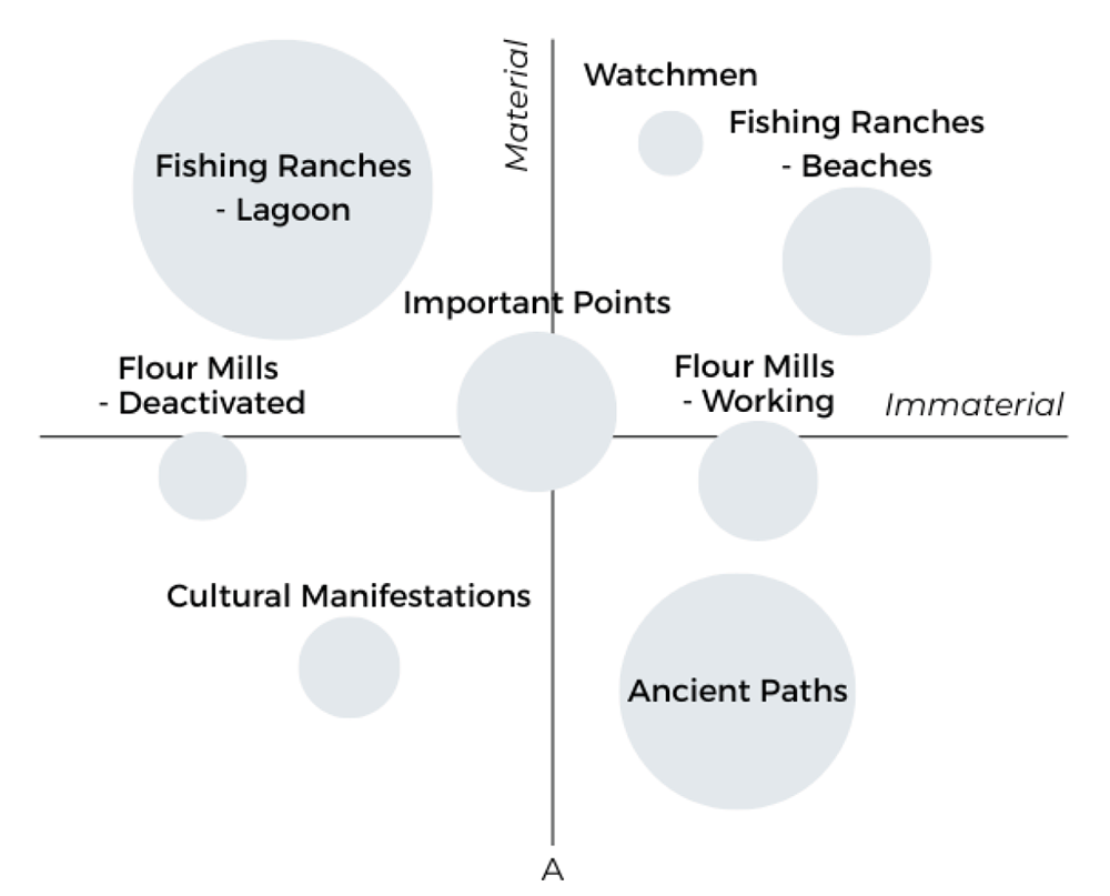
The identified assets were classified according to their level of importance (Figure 2) and quantified based on the number of times they were mentioned during the interviews. The size of the circle is proportional to its importance, and it is possible to see that the distribution of the circles maintains harmony between the material and immaterial categories, demonstrating the close connection between the territory and the emotional memories created in those spaces.
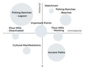
Classification of the level of importance and categorization (tangible and intangible) of the identified historical, cultural, and natural heritage sites. The circle size is proportional to its importance
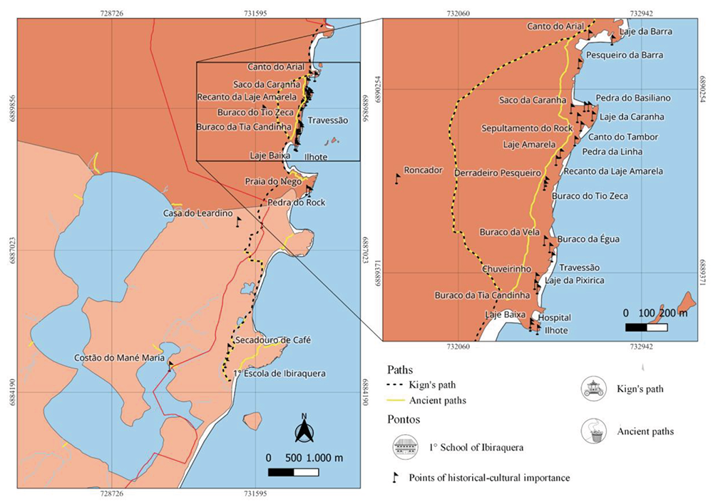
The mapping identified historical, cultural, and natural heritage sites, such as fishing ranches and coastal lookouts, flour mills, and historical and important landmarks. Toponyms were also identified, created, and imbued with meanings derived from collective construction, as well as traditional fishing routes that continue to exist and correspond to the route between the community and fishing areas, whether marine or lagoonal (Figure 3). These elements are formed by the relationship between the population and the space and are an expression of empirical knowledge of an identity-related nature.
Along traditional paths, places identified by toponyms carry historical, cultural, and emotional aspects of the community. Many of the paths shown are for nature trails in the region. Like the "King's Way," it is the oldest, having been created and traveled by Emperor Dom Pedro II and his cavalry. During the journey through the most preserved part and currently the only section truly entitled "Caminho do Rei" (King's Path), which connects Praia do Luz to Lagoa Doce in Praia do Rosa, you will find the ruins of the first elementary school in Ibiraquera. As a fisher recounts, "Several of my friends studied there, that first school was demolished when I was about 15 years old, and today I am 67. It was the first school, and they transferred to Ibiraquera.
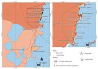
Route of the “King’s Trail” recreated from accounts, existing and used fishing trails, and historical sites in the community of Ibiraquera, Santa Catarina, Brazil
Currently, many of the old access routes to fishing grounds pass through private property, creating a barrier between fishermen and their livelihood due to the installation of private gates. Scattered throughout the territory and intersecting the four main beaches near the territory, it was possible to identify historical and cultural aspects that permeate the community, such as the meanings of place names. Praia Vermelha (Vermelha’s Beach) is so named because of the red clay that came down from the hill on a stormy day; Praia do Rosa (Pink Beach) gets its name from a large and well-known family with the surname "Rosa"; and at Praia do Luz, the elders say that at night all kinds of lights appear, from fireflies to meteors; about Praia do Ouvidor, a fisher explains:
“At school, when they surrounded the mullet and the pipe whistled, we could hear it in the school. The teacher would say, ‘Get out, they’re surrounding the Ouvidor.’ Before the Nordeste (wind) came, there was no television or anything, and everything was silent. They would gather there and we would listen, which is why it is called Ouvidor (listener), because it is like a basin, with the hills trapping the sound so you can hear it” (João, 2023).
The roots of the three original families can still be seen today, both in the members themselves and in their children, grandchildren, and great-grandchildren who still live and work in the community, maintaining the legacy of fishing and agriculture, as well as in the stories that gave rise to the place names. Thirty historical sites of importance to the community were mapped, twenty-three of which are located along the "Caranha Trail," an original path that follows the coast and connects the beaches of Ouvidor and Barra da Ferrugem, both in Garopaba. The trail is part of the Brazilian Trail System and is widely used for tourism and environmental education (Figure 3). Along the trail, many names were given in honor of former community figures, some became known for physical characteristics of the location itself, and others carry their own stories.
In addition, fishing ranches are strategically located facilities on the seashore, lagoons, rivers, or bays. They serve to organize fishing work, protect and repair boats, make and repair fishing gear, and provide a gathering place for fishermen, friends, and family. It is in this context that artisanal fishing emerges as an activity that generates genuine moments of sociability. The ranch is a meeting place, serving as a space for conversation and food, such as baking freshly caught fish on the beach. As one fisherwoman recounts:
“I was born on the Ouvidor ranch, when we lived there, and we moved when I was eight,” or “when my children were little, we slept there on the ranch, when there was no school and they were very young. My daughter, who was one year old, slept in a hammock, and after they started going to school, it became more difficult, but during the holidays, they spent much time on the beach, and they loved it” (Sônia, 2023).
Given this, ninety-two fishing huts were counted along the banks of Ibiraquera Lagoon, each belonging to a single family. The elements that make up the ranchos are part of the families that occupy them, bearing the name of the family that built them or the owner of the boat, as one fisher explains:
“In the Porto Novo rancho, the table we use is my great-grandmother’s old loom, which belonged to my mother, who gave it to us to put there (Paulo, 2023)”.
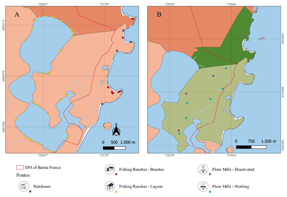
There are still holes where the sticks were stuck to weave the cloth. She made more blankets, but also clothes, and sold everything. That was her life. Between the beaches of Rosa Sul and Rosa Norte, Vermelha and Ouvidor, there are twenty-three coastal marine ranches, as well as five lookout posts (Figure 4 A). Lookout posts are small structures built near the coast, preferably at higher points such as hills or banks, where it is possible to observe the sea without interference. During the mullet season, these locations are always manned by a fisher, whose job is to watch the movement of fish shoals, as well as the movement of currents and sea conditions, such as wind and waves, to advise the rest of the crew on the best time to fish.
However, settlements on the banks have intensified the closure of access to the lagoon, restricting passage to the fishing huts. Furthermore, increased real estate speculation in areas on the slopes of the lagoon highlights socio-environmental threats, such as irregular construction in wetlands, the installation of private warehouses that encroach on the banks of the lagoon, and the discharge of sewage without adequate treatment into water bodies.
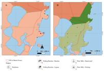
Historical-cultural and natural heritage of Azorean descendants in Southern Brazil: A: Fishing huts on the coastline distributed along the main beaches accessible to the community and their respective lookouts, in addition to huts along the edges of Ibiraquera Lagoon, and B: Flour mills in the territory (the colors highlight the neighborhoods)
The fields are also part of Azorean culture, and farinhada is an intangible heritage that manifests itself in the months leading up to the fishing season, coinciding with winter and the mullet season. Production begins in April and is taken to the ranches during the fishing season. It consists of six stages within the flour mills: scraping, washing, sifting, pressing, sieving, and baking. A fisher recounts, “Back then, it was all farmland up here, with cassava, corn, and people gathering firewood” (Joel, 2023). Currently, there are about ten flour mills in the Ibiraquera region, only six of which are still in operation. Due to the bureaucratic processes required for commercialization, families produce flour for their own consumption (Figure 4 B). Before the construction of the BR 101 highway, there were more than a hundred mills, and the land in the community was used for cassava plantations. The cultural and social background associated with flour mills and flour production is highlighted in the account of a fisherwoman:
"I would go there and plant cassava, the community would come together and help, and we would work on one field and then another, and when someone helped, they would give you a bag, and that's how it was" (Joana, 2023).
Traditional celebrations took place on the beaches and in community homes. The celebration of the "flag rosary" consisted of making a promise to a specific saint. The promises were made by bakeries in sweet bread, and the money raised from the sale was directed to the saint or the church. In Divino Espírito Santo, the statue would pass by and remain in homes for around four to five days, where a meal (meat or fish) would be prepared and sold. This festival was always held in winter. The day of Nossa Senhora de Navegantes represents one of the oldest and most traditional celebrations in the community. More than seventy years ago, the celebration took place in two ways, both at sea and on land, and the beaches were packed. The saint would come and go from Garopaba in rowboats, while the residents waited on the beaches, praying, and she would stay a week in each community, resting.
The Terno de Reis takes place during the Christmas period until January 6. On Three Kings Day, people would go from house to house singing at night, accompanied by guitars and tambourines. Groups of residents sang three or four songs in the street and waited in front of houses. When the doors opened, they would go inside, play, chat, and then continue their way. "Sometimes they would spend the whole night in just two or three houses, because they would eat and drink" (João, 2023). The ox festival is no longer held, according to a fisher, who says, "The last one was here at my father's house a few years ago" (João, 2023). It should be noted that this practice was banned in the state of Santa Catarina in 1997 by the Supremo Tribunal Federal (Federal Supreme Court - STF). The number of houses nearby makes it difficult to carry out the tradition.
“They break down walls, ruin the vegetables, but before it was all large plots of land. Last time, they chopped down a large cassava field, took a lot of oranges, food, and drink, and the whole community came here to the land, and they ate everything, stole chickens and turkeys, and we didn't mind, they were all natives, and the party went on for about three to four days" (Luiz, 2023).
However, due to pressure from tourism and the replacement of native residents by current "outsiders," many of these cultural manifestations have begun to reduce their presence and frequency in the territory, since the new residents have no historical or emotional ties to the traditions, making it difficult to preserve and transmit the historical, cultural, and natural aspects of the community.
TERRITORIAL IDENTITY AND HISTORICAL, CULTURAL, AND NATURAL HERITAGE OF THE AZORES
In Azorean coastal communities, the historical, cultural, and natural heritage is easily perceived, since fragments of this heritage are influenced by customs and traditions, popular religiosity, fishing techniques, typical foods, and handicrafts (Ambroziak, 2023). These heritage sites embody the concept of territory, one of the most important characteristics that define traditional groups. The fishing territory, occupied for generations, is not defined solely by its size or the natural resources it contains, but also by the symbols that represent this occupation over time.
The historical and cultural environment, which integrates tangible and intangible elements, is part of the cultural values created throughout history and involvement with the local physical space (Ocal, 2016), integrating the relationships between actors and nature. The connections between heritage and territorial identity can be determined by emotional aspects, such as motivations, values, and feelings involved (Alzina; Escoda, 2007), in addition to territoriality, which spatially nourishes and generates links between landscapes, the environment, and social actors, including a cultural view of the environment (Cuenca-López et al., 2021).
Therefore, the spatiality of coming and going in fishing is manifested in the symbolic construction of the paths that cross the territory, becoming part of the social and territorial identity of these groups (Fonseca, 2014). The need for access to farming areas and the beach led to an organic urban layout consisting of short streets and paths, almost always ending at the beach or the bottom of a hillside. The traditional routine of these peoples is characterized by the passing down of knowledge from grandfather to father to son, from the oldest to the youngest, and/or from the masters to the rest of the crew on board, and their knowledge of these routes in the territory is no different (Rios, 2016).
According to Cardoso (2003, p. 119) “(...) fishing is a human activity that represents a form of land use. Its uniqueness lies in the combination of aquatic and terrestrial environments”. The beach is also a workplace, where nets and boats are maintained and stored, and fish are cleaned (Rosa; Castells, 2022). According to the authors, the ranches are the result of self-construction, some built of wood and others of masonry, revealing part of each fisher's identity, which is expressed in the color, decorations, and name of the ranch. Thus, the presence of ranches symbolizes the materialization of the fishing territory.
Another historical and cultural treasure of the Santa Catarina coast is the farinhada. Extraction techniques and culinary uses are attributed to Guarani influences, while the handling of equipment and machinery in the mills is attributed to immigrants from the Azores (Braganholo, 2017). The author reiterates that cassava, possibly originating in the Amazon region and selected for millennia by the peoples who inhabited that region, remains to this day an important reference in Brazilian food culture. According to Avellar (1993), indigenous culture left its mark on Ibiraquera, mainly in food (peanuts, cassava and derivatives-flour, beiju, bijajica), fishing tools, and basketry and mat weaving. Flour-making is part of the identity of these communities, as it creates spaces for exchange between families and the community beyond the process of making flour itself.
In addition, artisanal mullet fishing was registered as intangible cultural heritage in Santa Catarina through Decree 2.504/2004 (Brasil, 2004). Their practices and communal spaces, such as ranches, create environments for community socialization and knowledge exchange. Religious celebrations, by involving moments of awareness and communion, enable greater socialization among community members, establishing bonds of sharing.
Another aspect shaped by territorial identity is the particular and collective nomenclature of places (toponymy), justified by their histories and characteristics. These stories form the framework that surrounds the image created by these interconnected elements of the community, constituting the historical, cultural, and natural heritage of this web of relationships created over time and through permanence in the territory. UNESCO's definition of natural heritage emphasizes the aesthetic notion of landscape, its scenic values, systemic views on the functioning of nature, linking universal value to beauty, science, and conservation, among the Brazilian cultural heritage sites listed in Art. Article 216 of the Federal Constitution of 1988 (Brasil, 1988) includes nature as part of the identification, action, and memory of traditional populations (Pereira, 2018).
In Brazil, natural heritage has two definitions: one linked to international experience, understood as the grandiose beauty of monumentality and untouchability, and another involving the human element, interpreted as part of natural processes and the relationships created, connecting with social memory (Pereira, 2018). Based on this concept, individual and collective experiences from an everyday perspective integrate the identification of other natures, such as memory itself, stories, and practices (Scifoni, 2006b).
Therefore, while natural heritage encompasses the perceptions and emotions surrounding the use and transformation of nature, traditional communities integrate this heritage into their historical and cultural construction. By carrying particular aspects individually and collectively, nature becomes an inseparable part of territorial identity and, consequently, of historical and cultural tangible and intangible heritage. In this way, the "mapped" elements represent the product of everyday social relations, structuring the importance of objects for the link of interaction, incorporated both in local tradition and in government policies (Lima; Costa, 2012).
To this end, the elements that construct these notions of heritage are diverse and manifest throughout the territory. The assets identified in this study, based on the actors and methodologies addressed, represent only a fraction of all aspects that make up the historical, cultural, and natural spheres of the region. Certain elements previously identified, such as the use and planting of butiazeiros, which are of economic, ecological, and cultural importance, with the use of fruits and straw from dried leaves (Hanazaki et al., 2012); the production of baskets and mats, which are part of the indigenous cultural heritage (Avellar, 1993); among others, were not included in this study, but are essential for a complete perspective of the region's tangible and intangible heritage.
While aspects of identity involving historical, cultural, and natural heritage characterize the territory, threats affecting the Ibiraquera community, especially those related to biodiversity and natural environments, generate socio-environmental consequences beyond degradation and environmental awareness itself, affecting the reproduction of the community's ways of life.
FINAL CONSIDERATIONS
The historical, cultural, and natural heritage of the descendants of Azoreans in Ibiraquera was characterized by fishing ranches, flour mills, traditional paths, cultural manifestations, and points of historical importance identified by toponyms. Engagement with space, over generations and through its use and appropriation, has built a sense of territoriality among the traditional population of Azorean descendants. The heritage interacts with aspects of sociability and the spatial changes experienced by the community. Future research may advance understanding of the gains resulting from the convergence of public policies for the protection of tangible and intangible heritage, enabling expansion aimed at participation and decision-making by multilevel actors. New research is encouraged by participatory mapping techniques that engage local populations, aiming to create synergies between local and scientific knowledge for the recovery of heritage and the promotion of efficient mechanisms for the protection of traditional territories.
Similarly, the inclusion of participatory methods, such as mapping and social cartography, should be part of municipal zoning plans, as well as the allocation of subsidies for land use plans that promote community dialogue. The search for methods that highlight and promote community dialogue with genuine participation by social actors sheds light on their worldviews and perceptions of the demands and problems facing the territory and the threats to Azorean heritage.
ACKNOWLEDGMENTS
I would like to thank the Santa Catarina State Research and Innovation Support Foundation (FAPESC) and Anima Institute for granting the scholarships that made this research possible. I also would like to thank the entire community of small-scale fishers in the Ibiraquera region, who opened the doors of their homes and shared their memories with me.
DATA AVAILABILITY
The data that support the findings of this study can be made available, upon reasonable request, from the corresponding author [Lara da Silva].
References
-
ALZINA, R. B.; ESCODA, N. P. Las competencias emocionales. Educacíon XX1. Universidad Nacional de Educacíon a Distancia. Madri, España, v. 10, p. 61-82, 2007. https://doi.org/10.5944/educxx1.1.10.297
» https://doi.org/10.5944/educxx1.1.10.297 -
AMBROZIAK, R. S. Festa do Divino Espírito Santo na região de Florianópolis, SC: Reflexões sobre as práticas religiosas populares de origem açoriana. Revista del CESLA (International Latin American Studies Review). Universidad de Varsovia, Centro de Estudios Americanos, n. 31, 2023. https://doi.org/10.36551/2081-1160.2023.31.69-96
» https://doi.org/10.36551/2081-1160.2023.31.69-96 -
AVELLAR, M. L. C. Ibiraquera: A história de um lugar... um movimento singular e universal. 1993. Dissertação de Mestrado em Educação: Centro de Educação (CED). Universidade Federal de Santa Catarina (UFSC) . p. 187, 1993. Disponível em: http://repositorio.ufsc.br/xmlui/handle/123456789/75891 Acesso em: 05 mai. 2024.
» http://repositorio.ufsc.br/xmlui/handle/123456789/75891 -
BERNARD, H. R. Research Methods in Anthropology: Qualitative and Quantitative Approaches. Altamira Press - Rowman & Littlefield Publishers, Inc. e. 4, 2006. Disponível em: http://ndl.ethernet.edu.et/bitstream/123456789/40820/1/17.pdf.pdf Acesso em: 20 mar. 2024.
» http://ndl.ethernet.edu.et/bitstream/123456789/40820/1/17.pdf.pdf -
BRAGANHOLO, M. V. Engenhos de Farinha: história, memória e resistência no litoral catarinense. 2017. Dissertação (Mestrado em Ciências Sociais em Desenvolvimento, Agricultura e Sociedade). UFRRJ: Universidade Federal Rural do Rio de Janeiro. Rio de Janeiro, p. 115, 2017. Disponível em: https://tede.ufrrj.br/jspui/handle/jspui/2368 Acesso em: 20 mar. 2024.
» https://tede.ufrrj.br/jspui/handle/jspui/2368 -
BRASIL. Decreto nº 6040, de 7 de fevereiro de 2007. Institui a Política Nacional de Desenvolvimento Sustentável dos Povos e Comunidades Tradicionais. Brasília, DF, 2007. Disponível em: https://www.planalto.gov.br/ccivil_03/_ato2007-2010/2007/decreto/d6040.htm Acesso em: 04 ago. 2025.
» https://www.planalto.gov.br/ccivil_03/_ato2007-2010/2007/decreto/d6040.htm -
BRASIL. Decreto nº 2.504, de 29 de setembro de 2004. Institui as formas de Registro de Bens Culturais de Natureza Imaterial ou Intangível que constituem o Patrimônio Cultural de Santa Catarina. Florianópolis, SC, 2004. Disponível em: http://server03.pge.sc.gov.br/LegislacaoEstadual/2004/002504-005-0-2004-004.htm Acesso em: 04 ago. 2025.
» http://server03.pge.sc.gov.br/LegislacaoEstadual/2004/002504-005-0-2004-004.htm -
BRASIL. Constituição (1988), Art. 216. Constituição da República Federativa do Brasil. Brasília, DF: Senado Federal, 1988. P. 592. Disponível em: https://www.gov.br/palmares/pt-br/midias/arquivos-menu-departamentos/dpa/legislacao/art-215-216-art-68.pdf Acesso em: 04 ago. 2025.
» https://www.gov.br/palmares/pt-br/midias/arquivos-menu-departamentos/dpa/legislacao/art-215-216-art-68.pdf -
CARDOSO, E. S. Da apropriação da natureza à construção de territórios pesqueiros. GEOUSP - Espaço e tempo. São Paulo, n. 14, p. 119-125, 2003. https://doi.org/10.11606/issn.2179-0892.geousp.2003.123837
» https://doi.org/10.11606/issn.2179-0892.geousp.2003.123837 -
CASTILLO, T. I.; BAIGÚN, C.; TRIMBLE, M. An Assessment of Small‑scale Fisheries of the Paraná River Delta Through the Sustainable Livelihoods Approach. Human Ecology. Universidad Nacional de Rosario - Zavalla. Argentina, p. 13, 2023. https://doi.org/10.1007/s10745-023-00454-5
» https://doi.org/10.1007/s10745-023-00454-5 -
CONCEIÇÃO, L. C. A.; MARTINS, C. M.; SANTOS, M. A. S.; ARAÚJO, J. G.; MONTEIRO, E. P. A pesca artesanal e a sucessão geracional no município de Maracanã, estado do Pará, Brasil. Guaju - Revista Brasileira de Desenvolvimento Territorial Sustentável. Matinhos, v. 6, n. 1, p. 70-85, 2020. https://doi.org/10.5380/guaju.v6i1.71232
» https://doi.org/10.5380/guaju.v6i1.71232 -
COHENCA, D.; SCHERER, M. E. G.; VIEIRA, C. A. O. Ocupação da Zona Costeira do Sul de Santa Catarina: Uma análise histórica de vetores e processos. Geosul - Revista do Departamento de Geociências. Florianópolis, v. 32, n. 64, p. 47-65, 2017. https://doi.org/10.5007/2177-5230.2017v32n64p47
» https://doi.org/10.5007/2177-5230.2017v32n64p47 -
COSTA, N. O.; GORAYE, A.; PAULINO, P. R. O.; SALES, L. B.; SILVA, E. V. Cartografia social uma ferramenta para a construção do conhecimento territorial: Reflexões teóricas acerca das possibilidades de desenvolvimento do mapeamento participativo em pesquisas qualitativas. ACTA Geográfica, Ed. Esp. V Congresso Brasileiro de Educação Ambiental e Gestão Territorial. Fortaleza-CE, p. 73-86, 2016. https://doi.org/10.18227/2177-4307.acta.v10iee.3820
» https://doi.org/10.18227/2177-4307.acta.v10iee.3820 -
CUENCA-LÓPEZ, J. M.; MARTÍN-CÁCERES, M. J.; ESTEPA-GIMÉNEZ, J. Teacher training in heritage education: good practices for citizenship education. Humanities & Social Sciences Comunication. University of Huelva, Huelva. Spain, v. 8, n. 62, 2021. https://doi.org/10.1057/s41599-021-00745-6
» https://doi.org/10.1057/s41599-021-00745-6 -
De FREITAS, R. R.; BELTRAME, A. V. Mudanças no uso e cobertura da terra do entorno da Lagoa de Ibiraquera (Santa Catarina, Brasil) no período de 1957 a 2011. Geosul. Florianópolis, v. 27, n. 54, p. 77-98, 2012. https://doi.org/10.5007/30679
» https://doi.org/10.5007/30679 -
De FREITAS, R. R.; COSTA, R. C.; ALVITE, C. M. C.; BALENSIEFER, D. C.; BARROS, C. R. M. B.; PRADO, J. H. Challenges for fishers’ engagement in Marine Protected Areas: Lessons from Right Whale Environmental Protection Area, Southern Brazil. Marine Policy. v. 143, ed. 2, 2022. https://doi.org/10.1016/j.marpol.2022.105135
» https://doi.org/10.1016/j.marpol.2022.105135 - EQUIPE DE DESENVOLVIMENTO QGIS. Quantum GIS Desktop: Sistema de Informação Geográfica. [Software]. Versão 3.28.3. Osgeo, 2023.
-
FEIBER, S. D. O papel do patrimônio histórico na construção do lugar: A Igreja Nossa Senhora de Fátima em Cascavel - PR. 2007. Dissertação (Mestrado). Setor de Ciências da Terra da Universidade do Paraná, Curitiba. P. 99, 2007. Disponível em: https://hdl.handle.net/1884/25735 Acesso em: 20 mar. 2024.
» https://hdl.handle.net/1884/25735 -
FEIJÓ, A. C. C. A Percepção Ambiental dos Turistas Hospedados na Pousada Fazenda do Rosa, localizada no Município de Imbituba/SC. 2021. Tese de Graduação. Universidade do Sul de Santa Catarina, p. 82, 2021. Disponível em: https://repositorio.animaeducacao.com.br/handle/ANIMA/14494 Acesso em: 20 mar. 2024.
» https://repositorio.animaeducacao.com.br/handle/ANIMA/14494 -
FONSECA, C. F. Cartografia social, terra e território. ACSELRAD, H. (Org.) Revista Brasileira de Estudos Urbanos e Regionais. Instituto de Pesquisa e Planejamento Urbano e Regional - Universidade Federal do Rio de Janeiro (Coleção Território, Ambiente e Conflitos Sociais). Rio de Janeiro, v. 16, n. 1, p. 223-227, 2014. https://doi.org/10.22296/2317-1529.2014v16n1p223
» https://doi.org/10.22296/2317-1529.2014v16n1p223 -
FREITAS, L. E.; NUNES, F. S. B. Potencial de SIG participativos na Gestão de Riscos de Desastres e Emergências em Saúde. Saúde Debate. Rio de Janeiro, v. 44, n. especial 2, p. 214-229, 2020. https://doi.org/10.1590/0103-11042020E215
» https://doi.org/10.1590/0103-11042020E215 -
GOOGLE. Vista aérea das cidades de Garopaba e Imbituba - Santa Catarina. Google Earth Pro. [S.l.]: Google, 2023. 1 imagem de satélite. Disponível em: https://www.google.com/earth/ Acesso em: 20 nov. 2023.
» https://www.google.com/earth/ -
GORAYEB, A.; MEIRELES, A. J. A.; SILVA, E. V. Cartografia social e cidadania: experiências do mapeamento participativo dos territórios de comunidades urbanas e tradicionais. Editora Expressão gráfica. p. 196, 2015. Disponível em: https://www.scribd.com/document/585394750/Cartografia-Social-e-Cidadania-indd-1 Acesso em: 20 mar. 2024.
» https://www.scribd.com/document/585394750/Cartografia-Social-e-Cidadania-indd-1 -
HANAZAKI, N.; ZANK, S.; PINTO, M. C.; KUMAGAI, L.; CAVECHIA, L. A.; PERONI, N. Etnobotânica nos Areais da Ribanceira de Imbituba: Compreendendo a Biodiversidade Vegetal Manejada para Subsidiar a Criação de uma Reserva de Desenvolvimento Sustentável. BioBrasil - Biodiversidade Brasileira. v. 2, n. 2, p. 50-64, 2012. https://doi.org/10.37002/biodiversidadebrasileira.v2i2.273
» https://doi.org/10.37002/biodiversidadebrasileira.v2i2.273 -
IBGE - Instituto Brasileiro de Geografia e Estatística. Censo demográfico do Brasil de 2022. 2022. Disponível em: https://censo2022.ibge.gov.br/panorama/ Acesso em: 20 mar. 2024.
» https://censo2022.ibge.gov.br/panorama/ -
JUNIOR, A. V.; COLI, L. R.; CÁCERES, L. S. R.; WANDERLEY, L. J.; HOFFMAN, M. B.; PINTO, R. G.; ASSIS, W. F. T. Cartografia social e dinâmicas territoriais: Marcos para o debate. ACSELRAD, H. (Org.) Instituto de Pesquisa e Planejamento Urbano e Regional, Universidade Federal do Rio de Janeiro (Coleção Território, ambiente e conflitos sociais, n. 2). Rio de Janeiro, n. 2, p. 225, 2010. ISBN 978-85-86136-06-1. Disponível em: https://conflitosambientais.org/wp-content/uploads/2023/06/Cartog.2023.HA_.Marcos.pdf Acesso em: 05 mai. 2024.
» https://conflitosambientais.org/wp-content/uploads/2023/06/Cartog.2023.HA_.Marcos.pdf -
LANDIM NETO, F. O.; COSTA, N. O.; FILHO, N. S. P.; GORAYEB, A. A cartografia social na comunidade Waldemar de Alcântara: Instrumento de Luta por melhores condições de vida. In: I Congreso Extension y Sociedad de la Associación de la Universidades del Grupo Montevideo - AUGM, 2013. Anais […] [RESUMENES Y TRABAJOS COMPLETOS I Congreso Extension y Sociedad], Montevideo - UY, v. 1, p. 1-8, 2013. Disponível em: https://01908729815274380967.googlegroups.com/attach/863a53961515f458/519_resumen892(1).pdf?part=0.1&vt=ANaJVrEWausdh4ark3vbpzqT0ZU9I2nYsV0K-B2BB0IMaChoqO5bYrGs8liNZD2hpCn7oFjnP-PIcM39Pqxup5Bmsc0CyH8CLgAXAnva1XUJXTFrdVhY-1k Acesso em: 20 mar. 2024.
» https://01908729815274380967.googlegroups.com/attach/863a53961515f458/519_resumen892(1).pdf?part=0.1&vt=ANaJVrEWausdh4ark3vbpzqT0ZU9I2nYsV0K-B2BB0IMaChoqO5bYrGs8liNZD2hpCn7oFjnP-PIcM39Pqxup5Bmsc0CyH8CLgAXAnva1XUJXTFrdVhY-1k -
LIMA, M.; COSTA, S. Cartografia social das crianças e adolescentes ribeirinhas/quilombolas da Amazônia. Revista Geografares. n. 12, p. 76-113, 2012. https://doi.org/10.7147/GEO12.3189
» https://doi.org/10.7147/GEO12.3189 -
NETTO, S. A. Lagoas costeiras da Áreas de Proteção Ambiental da Baleia Franca. Plano de Manejo de Unidade de Conservação Federal - APA da Baleia Franca. Imbituba - SC. 2018. Disponível em: 20 mar. 2024. https://www.gov.br/icmbio/pt-br/assuntos/biodiversidade/unidade-de-conservacao/unidades-de-biomas/marinho/lista-de-ucs/apa-da-baleia-franca/arquivos/5_lagoas_costeiras_apa_da_baleia_franca.pdf Acesso em: 20 mar. 2024.
» https://www.gov.br/icmbio/pt-br/assuntos/biodiversidade/unidade-de-conservacao/unidades-de-biomas/marinho/lista-de-ucs/apa-da-baleia-franca/arquivos/5_lagoas_costeiras_apa_da_baleia_franca.pdf -
OCAL, T. Necessity of Cultural Historical Heritage Education in Social Studies Teaching. Creative Education, v. 7, p. 396-406, 2016. https://doi.org/10.4236/ce.2016.73039
» https://doi.org/10.4236/ce.2016.73039 -
PEREIRA, D. C. Patrimônio Natural: Atualizando o debate sobre identificação e reconhecimento no âmbito do IPHAN. Revista CPC. Universidade de São Paulo - São Paulo. v. 13, n. 25, p. 34-59, 2018. https://doi.org/10.11606/issn.1980-4466.v13i25p34-59
» https://doi.org/10.11606/issn.1980-4466.v13i25p34-59 -
RIOS, K. A. N. Avanços e contradições da pesca artesanal no Estado da Bahia, Brasil: A necessidade da regularização dos territórios pesqueiros. 2015. XV Encuentro de Geógrafos de América Latina: Por una América Latina unida y sostenible, La Habana, v. 1, p. 578, 2015. Disponível em: http://observatoriogeograficoamericalatina.org.mx/egal15/Geografiasocioeconomica/Geografiaeconomica/03.pdf Acesso em: 20 mar. 2024.
» http://observatoriogeograficoamericalatina.org.mx/egal15/Geografiasocioeconomica/Geografiaeconomica/03.pdf -
RIOS, K. A. N. Conflitos e resistência: comunidades tradicionais pesqueiras da Bahia. Cadernos do CEAS - Revista crítica de humanidades. Salvador, n. 237, p. 347-364, 2016. https://doi.org/10.25247/2447-861X.2016.n237.pp.%20347-364
» https://doi.org/10.25247/2447-861X.2016.n237.pp.%20347-364 -
ROSA, A. H.; CASTELLS, A. N. G. Entre os Ranchos e o Mar: Leitura das formas de apropriação do espaço público dos Ranchos da Bica na Praia da Tapera - Florianópolis/SC. Revista de Arquitetura, Cidade e Contemporaneidade - PIXO. n. 23, v. 6, p. 168, 2022. https://doi.org/10.15210/pixo.v6i23.4005
» https://doi.org/10.15210/pixo.v6i23.4005 -
SCIFONI, S. Os diferentes significados do patrimônio natural. Diálogos, DHI/PPH/UEM, v. 10, n. 3, p. 55-78, 2006a. Disponível em: https://periodicos.uem.br/ojs/index.php/Dialogos/article/view/38966 Acesso em: 20 mar. 2024.
» https://periodicos.uem.br/ojs/index.php/Dialogos/article/view/38966 - SCIFONI, S. A construção do patrimônio natural. FFLCH/USP (LABUR). Universidade de São Paulo. São Paulo, p. 199, 2006b. https://doi.org/10.11606/T.8.2006.tde-27122006-104748
-
TEMPASS, M. C. Sobre a questão do patrimônio cultural: repensando princípios e fins. Cadernos de pesquisa do CDHIS, Uberlândia. n. 35, p. 133-144, 2006. https://doi.org/10.14393/cdhis.v1i35.504
» https://doi.org/10.14393/cdhis.v1i35.504
-
ASSOCIATE EDITOR
Silvio Carlos Rodrigues - 0000-0002-5376-1773

 Source: The authors (2025);
  Source: The authors (2025).
 Source: The authors (2025);
  Source: The authors (2025);