
 Environmental Governance and Degradation Dynamics in the Cerrado - Brazilian Biome: Empirical and Institutional Evidence in the State of Tocantins
Abstract
Environmental degradation in tropical biomes has become one of the main contemporary challenges, requiring integrated institutional responses based on evidence. This article analyzes the dynamics of environmental degradation in the Cerrado biome, with an emphasis on the state of Tocantins between 2013 and 2023. The investigation is based on the observation that deforestation, wildfires, and environmental infractions show significant recurrence in this territory, configuring spatiotemporal patterns that demand stronger institutional articulation and reinforcement of environmental governance. The research adopts a mixed methodological approach, combining content analysis and statistical techniques, using secondary data extracted from public and auditable platforms such as INPE, IBAMA, the World Bank, MapBiomas, and IBGE. The data were organized into time series, converted, and standardized to ensure comparability among indicators. The results reveal Tocantins’ significant contribution to vegetation suppression in the Cerrado, both in terms of deforested areas and burned extent, in addition to a high concentration of environmental infraction notices issued in the state. Structural limitations in administrative records were also identified, such as overlapping codifications and terminological inconsistencies, which hinder the proper classification of infringing conduct. The analysis highlights the need to strengthen environmental governance through federal integration, improved monitoring systems, and the formulation of territorially based public policies grounded in technical evidence and committed to the conservation of Cerrado ecosystems.
Keywords:
Ecological infractions; Native vegetation suppression; Spatio temporal dynamics; Territorial indicators; Monitoring using public data
Resumo
A degradação ambiental em biomas tropicais tem se consolidado como um dos principais desafios contemporâneos, exigindo respostas institucionais integradas e baseadas em evidências. Este artigo analisa a dinâmica da degradação ambiental no bioma Cerrado, com ênfase no estado do Tocantins, no período compreendido entre 2013 e 2023. A investigação parte da constatação de que os processos de desmatamento, queimadas e infrações ambientais apresentam recorrência significativa nesse território, configurando padrões espaço-temporais que demandam maior articulação institucional e fortalecimento da governança ambiental. A pesquisa adota uma abordagem metodológica mista, integrando análise de conteúdo e técnicas estatísticas, a partir de dados secundários extraídos de websites e plataformas governamentais e auditáveis com disponibilização de dados abertos. Os dados foram organizados em séries temporais, convertidos e padronizados para garantir a comparabilidade entre os indicadores analisados. Os resultados evidenciam a expressiva contribuição do Tocantins nos processos de supressão vegetal no Cerrado, tanto em área desmatada quanto em extensão queimada, além da concentração de autos de infração ambiental lavrados na unidade federativa. Verificaram-se ainda limitações na estrutura dos registros administrativos, como sobreposição de codificações e inconsistências terminológicas, que comprometem a categorização das condutas infracionais. A análise reforça a necessidade de fortalecimento da governança ambiental por meio da integração entre entes federativos, da qualificação dos sistemas de monitoramento e da formulação de políticas públicas com recorte territorial, baseadas em evidências técnicas e voltadas à conservação dos ecossistemas do Cerrado.
Palavras-chave:
Infrações Ecológicas; Supressão de Vegetação Nativa; Dinâmica Espaço-Temporal; Indicadores Territoriais; Monitoramento por Dados Públicos
INTRODUCTION
The intensification of human action on natural ecosystems has exposed Brazilian biomes to critical levels of degradation, requiring interdisciplinary approaches capable of integrating environmental data, legal frameworks and institutional mitigation mechanisms. In the national context, this complexity is accentuated by structural obstacles such as socio-spatial inequality, the discontinuity of public policies and the intricate division of responsibilities between spheres of government (Vargas, 2021; Alves; Azevedo, 2023).
The Cerrado (Brazilian biome), due to its ecological importance and territorial extension, is among the biomes most affected by accelerated landscape transformations, especially the loss of native vegetation due to deforestation and fires. These dynamics compromise not only the vegetation cover, but also the associated ecosystem services, such as water regulation and climate balance. In this scenario, the state of Tocantins emerges as one of the most pressured federal units, located in a region of ecological transition marked by intense deforestation (Silva, 2007).
In order to understand environmental degradation in all its complexity, it is necessary to investigate not only the biophysical factors at work, but also the gaps in monitoring and the institutional limits of environmental protection. From this perspective, the concept of environmental governance becomes central to assess the effectiveness of the State in coordinating integrated actions - from monitoring to accountability - anchored in technical evidence and auditable public data.
This study aims to analyze the dynamics of degradation in the Cerrado (Brazilian biome) of the state of Tocantins between 2013 and 2023 and its implications for environmental governance, in the light of public data and the current institutional structure, using secondary information on deforestation, fires and environmental fines. Using a mixed methodological approach - which combines content analysis and statistical techniques - the aim is to map spatio-temporal patterns of anthropogenic pressure, relating them to the institutional obstacles of environmental governance in the construction of responses adapted to territorial specificities.
The national literature on environmental governance shows that institutional fragmentation and the discontinuity of public policies are recurring factors that compromise the ability to respond of the State to ecological degradation (Vargas, 2021). In his study, Vargas (2021) points out that the lack of coordination between federal entities and regulatory instability create significant barriers to the effectiveness of environmental actions, especially in contexts marked by territorial inequalities.
Converging, Alves and Azevedo (2023) argue that environmental governance requires not only the existence of regulatory frameworks, but also effective integration among levels of government, based on technical evidence and territorial planning. These analyses make it possible to establish a critical benchmark for reading the reality of the state of Tocantins, making it possible to identify convergences or singularities in the patterns of environmental degradation and the institutional challenges to contain it.
The relevance of this study lies in the articulation between empirical data and the institutional limits of environmental governance, a topic that is still little explored at sub-national levels in the Cerrado biome. By highlighting anthropogenic pressures and the capacity of the State to respond, the research provides technical support for improving public policies at state and federal levels. It is also of interest to the academia, as it deepens the debate on environmental performance indicators, and to civil society, as it fosters accountability and participation mechanisms. For the corporate sector, the findings provide a basis for sustainable production practices in line with environmental legislation, especially in critical regions such as MATOPIBA (acronym that names the region that extends over the territories of four Brazilian states, formed with the first syllables of the names of these federative units: Maranhão, Tocantins, Piauí and Bahia).
METHODOLOGY
The spatial delimitation of the research fell on the state of Tocantins, a federal unit located in the northern region of Brazil, part of the northern portion of the Cerrado biome. This choice stems from the state significant contribution to indicators of deforestation, fires and environmental infractions, as demonstrated by secondary data extracted from the INPE - Instituto Nacional de Pesquisas Espaciais (National Institute for Space Research), IBAMA - Instituto Brasileiro do Meio Ambiente e dos Recursos Naturais Renováveis (Brazilian Institute for the Environment and Renewable Natural Resources) and MapBiomas - Mapeamento Anual da Cobertura e Uso do Solo do Brasil (Climate Observatory project that maps the land cover and land use of Brazil every year, monitoring changes in the territory) platforms. This approach is justified by the need to understand the territorial patterns of ecological degradation in an area of ecological transition and intense human pressure.
The choice of the state of Tocantins as the empirical universe of this research is based on its territorial relevance for understanding the operational limits of environmental governance in the Brazilian Cerrado biome. With a total area of 277,423.627 km², and an estimated population of 1,577,342 inhabitants, according to the latest census (IBGE, 2024), the State is mostly part of the Cerrado biome, with a significant presence of ecological transition areas, according to Porto et al. (2013), with an emphasis on grain production and the expansion of the MATOPIBA agricultural frontier (MAPBIOMAS, 2024b).
The research adopts a mixed methodological approach, combining qualitative and quantitative procedures in order to capture the complexity of the environmental processes analyzed. The initial stage consisted of an exploratory literature review, which, according to Dermeval et al. (2020), makes it possible to identify the current state of scientific production and locate gaps that have yet to be addressed.
The selection of sources prioritized recent and relevant materials, taken from recognized databases such as SciELO (2025), Web of Science (UNIVERSIDADE FEDERAL DE SÃO CARLOS, 2024) and Google Scholar (2024). Institutional documents produced by entities such as the IBAMA, the INPE, the IBGE - Instituto Brasileiro de Geografia e Estatística (Brazilian Institute of Geography and Statistics), the PNUMA - Programa das Nações Unidas para o Meio Ambiente (United Nations Environment Programme - UNEP), MAPBIOMAS and the World Bank Group (WORLD BANK) were also analyzed. Boolean operators were used in the search process, with combinations such as “environmental governance” AND “environmental indicators” and ‘deforestation’ AND “inspection”, with the aim of refining the results and ensuring adherence to the object of study.
For the qualitative approach, the content analysis technique was adopted according to the assumptions of Bardin (Valle; Ferreira, 2024). The public documents and reports extracted from the institutional platforms (IBAMA, INPE, MAPBIOMAS, etc.) were organized into a thematic corpus, structured around the categories: environmental infractions, anthropogenic pressures, federative governance and informational challenges. The analysis followed three main stages: (a) pre-analysis, with floating reading and definition of the categories; (b) exploration of the material, with manual coding and recurrence of terms and patterns; and (c) treatment of the results, with identification of inferences and critical interpretation, making it possible to expand the interpretative capacity in view of the institutional weaknesses observed in the state of Tocantins.
This analytical procedure made it possible to capture latent meanings in institutional discourses and highlight the operational limits of environmental governance.
In addition, statistical techniques were used to process data on deforestation and fires in the Cerrado biome, with an emphasis on the state of Tocantins. As argued by Leal et al. (2010), the use of quantitative procedures helps to identify patterns and trends, offering empirical support for the interpretation of environmental phenomena.
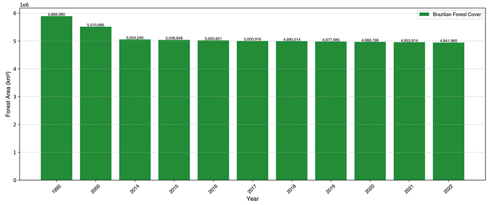
The statistical analysis was based on secondary data extracted from public institutional platforms such as TerraBrasilis/INPE (web platform developed by INPE, MapBiomas, WORLD BANK, IBGE and IBAMA. This data was organized into time series mainly covering the period from 2013 to 2023, with the exception of Figure 2, referring to the Brazilian forest cover, which uses a longer time series (1990 to 2022), as provided by the World Bank. This one-off expansion was intended to allow a long-term reading of the national trend of forest shrinkage, complementing the ten-year focus adopted in the other analyses centered on the state of Tocantins.
Procedures such as linear interpolation, territorial harmonization by federal unit and treatment of composite records were used to ensure comparability and reliability of data over time, as well as standardization in terms of nomenclature and units of measurement (with conversion from hectares to square kilometers).
The triangulation among scientific sources, geospatial bases and administrative documents consolidated the methodological robustness of the research. This integration strategy favored a critical, multi-scalar and technically grounded approach to the current challenges related to environmental conservation, governance and anthropogenic pressures in the Cerrado biome.
RESULTS
The results presented in this section are organized around three main axes: (i) empirical indicators of deforestation and fires in the Cerrado biome, with emphasis on the state of Tocantins, during the period from 2013 to 2023; (ii) incidence and distribution of environmental infraction notices issued in the State; and (iii) structural limitations of administrative records, especially regarding the codification of conduct and terminological standardization.
It also includes a preliminary analysis of the historical series of the Brazilian forest cover, based on World Bank data, covering the period from 1990 to 2022, with the aim of contextualizing the national pattern of vegetation shrinkage in which the case of the state of Tocantins is inserted. The following analyses were conducted using auditable secondary data, extracted from public platforms, standardized and organized into time series to ensure comparability among indicators.
Based on the World Bank data of 2022, the countries with the greatest extent of forest cover were identified using a standardization process that included translating names, excluding non-pertinent variables and interpolating missing values. Figure 1 shows the relative distribution between the two main contributing countries and the rest of the world (World Bank, 2024).
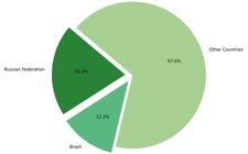
The graphical analysis shows that the Russian Federation concentrates 20,2% of the forest cover of the world, occupying the first position globally, while Brazil accounts for 12.2%, making it the second largest holder of forest areas. The other countries together account for 67,6% of the total. The data shows the significant concentration of the Global forest cover in just two nations.
The evolution of the Brazilian forest cover in the period from 1990 to 2022, based on data provided by the World Bank (2024) is represented in Figure 2. To ensure temporal consistency and facilitate comparative reading, the records were organized in continuous historical series, allowing the observation of gradual variations over the last three decades. The graph reflects the extent of forested areas in the country in absolute values, expressed in square kilometers.
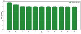
Over the period from 1990 to 2022, data show a continuous reduction of the forest cover in the Brazilian territory. Although the decreasing trend is not abrupt, there is a persistent negative oscillation in the extent of forested areas. The downward trajectory, although subtle in certain periods, is marked by constancy in the annual decrease of native vegetation, suggesting a dynamics of accumulated loss over time. The linearity of this trend reinforces the importance of its analysis in long time series, in order to identify structural patterns associated with forest suppression. (Climate Policy Initiative, 2023).
To understand the dynamics presented in Figure 2, which illustrates the percentage regression of the forest cover in the Brazilian territory over time, it was necessary to segment the data by periods. This approach made it possible to analyze the percentage of cumulative reduction between 1990 and 2022, based on available data, as detailed in Table 1.
The values presented correspond to the area of forest cover in square kilometers (km 2), considering the first and last year with data available in each period. For the 1990s, the variation between 1990 and 2000 was considered due to the absence of intermediate records between 1991 and 1999. For the decade of 2010, the analysis was carried out between 2014 and 2019, since the data available in the database are concentrated in this period. For the period from 2020 to 2022, the data of the respective years were used, since they presented complete records. Although this interval does not characterize a full decade, it was included in the table in order to enable temporal comparison with the other periods analyzed. The percentage reduction was calculated based on the relative difference between the initial and final values of each interval, reflecting the trend of forest cover loss over the last decades. In the cumulative total from 1990 to 2022, Brazilian forest loss was approximately 16.1%.
To estimate the reduction of the Brazilian forest cover over the analyzed periods, we used the percentage variation formula relative to the initial value, widely used in environmental time series studies:
In this equation, the Initial Value corresponds to the forest cover area recorded in the first year of the analyzed period, while the Final Value refers to the last year with data available in the respective interval. This method allows quantifying, in a standardized way, the proportional loss of vegetation, taking into account the initial basis of each period.
It should be noted that the percentages calculated for different periods are not cumulative, since each reduction is relative to the specific initial value of that interval. Therefore, the total reduction between 1990 and 2022 was calculated independently, based exclusively on forest cover values recorded in the years 1990 and 2022.
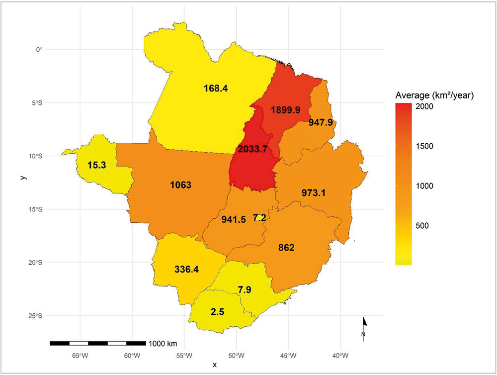
The annual average deforestation in the Cerrado biome, by federative unit, from 2013 to 2023, can be seen in Figure 3. Data extracted from the INPE database (2024a), were organized with spatial cutoff by state and temporal aggregates to compose an average per unit of the federation. The consolidation of information allows evaluating the relative contribution of each State in the dynamics of suppression of native vegetation in the Cerrado biome over the interval of eleven years.

In the time frame analyzed (2013 and 2023), consolidated data indicate a total of approximately 101,845 km2 of native vegetation suppressed in the Cerrado biome. The state of Tocantins had an annual average of 22,370 km2 deforested, which corresponds to 21.97% of the total observed in the biome during the analyzed period. This proportion places Tocantins among the States with the highest individual contribution to vegetation loss in the Cerrado biome. The spatial distribution of the means shows significant disparities between the federative units, suggesting the existence of zones of greater anthropic pressure and differentiated territorial dynamics regarding the exploitation of native plant resources.
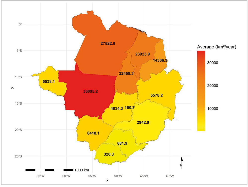
To identify the average annual area burned by State in the Cerrado biome, from Figure 4, we used the database contained in the series Scars of Fire made available by MapBiomas platform (2024). The original data, expressed in hectares, were converted to square kilometers, ensuring standardization of measurement units and enabling direct comparison with previously analyzed deforestation data. The consolidation of annual averages for the period from 2013 to 2023 allows identifying territorial patterns in the recurrence of fire events.
To ensure uniformity in measurement units, the data originally provided in hectares were converted to square kilometers (1 ha = 0.01 km 2), in order to compare with the deforestation metrics discussed above. From this adaptation, it was calculated the average annual area burned in each state of the Cerrado biome.
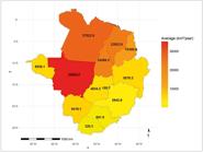
In the period from 2013 to 2023, there is a variation in the annual average of burned area among the states inserted in the biome analyzed. The distribution of the data shows significant concentrations of fire in certain territories, pointing to the existence of recurrent fires. The adaptation of the metric units used in the standardization of the data allowed the methodological harmonization with the deforestation indicators, allowing an integrated reading of the dynamics of plant cover loss by different pressure agents. The structure of the series reveals the average annual extent of the areas affected by fire, without distinguishing categories of use and coverage, which gives comprehensiveness to the analysis of the distribution of events.
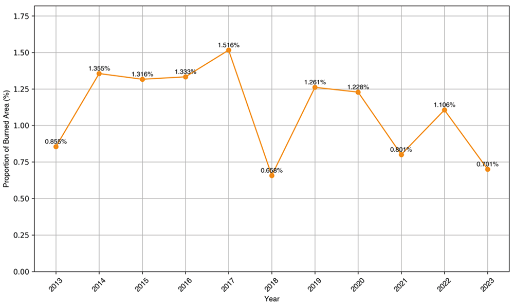
In the next step, the proportion of the burned area in the state of Tocantins is calculated in relation to the total areas affected by fire in the Cerrado biome, between 2013 and 2023 (Figure 5). Data were extracted from the series Scars of Fire, developed by the platform MapBiomas (2024a), and organized annually by federative unit. To ensure comparability, the official biome area of 2,036,448 km2 was adopted as a spatial reference, according to the limits defined by IBGE (2019). The conversion of the original units of hectare to square kilometers (1 ha = 0.01 km 2) and the standardization of the federal unit identifiers allowed to consolidate the proportional calculation between States.
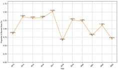
Proportion of the burned area in the state of Tocantins in relation to the total of the Cerrado Biome (2013-2023)
The data show that the state of Tocantins accounted for a substantial fraction of the burned area in the Cerrado biome over the period considered. The methodological delimitation adopted made it possible to identify the percentage contribution of the State in the context of fires recorded throughout the biome. The temporal and spatial organization of the information ensures the reliability of the calculations, allowing a precise analysis of the magnitude of fire losses in the territory of the state of Tocantins in relation to the total accumulated in the Cerrado biome.
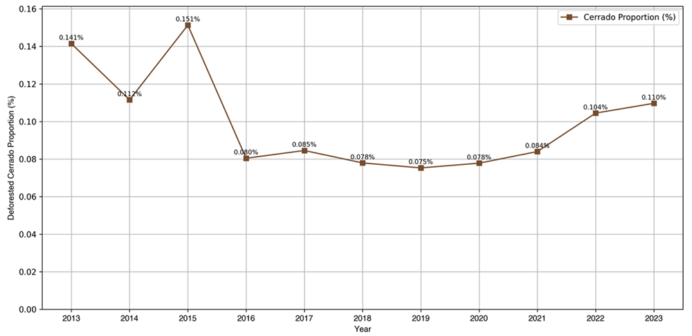
The proportion of deforested area in the state of Tocantins, in relation to the total deforested area in the Cerrado biome between 2013 and 2023 (Figure 6), was calculated based on data provided by the TerraBrasilis platform maintained by INPE (2024a). The records were organized by year and by federative unit, allowing the annual quantification of deforested area by State. For the proportional analysis, the official area of the Cerrado biome was adopted, estimated at 2,036,448 km2 according to the geographical limits of the Instituto Brasileiro de Geografia e Estatística (Brazilian Institute of Geography and Statistics) IBGE (2019). The standardization of the units and the temporal organization of the data confer methodological uniformity.
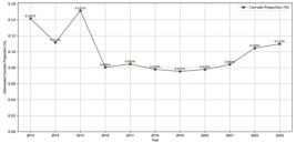
Proportion of deforested area in the state of Tocantins in relation to the total deforested area in this biome in the period between 2013 and 2023
The temporal distribution of the data shows that the state of Tocantins had an expressive participation in the dynamics of deforestation of the Cerrado biome during the analyzed period. The annual consolidation of deforested areas allows observing the variation in the proportional contribution of the State over the decennial series. The calculation criterion used ensures consistency with the other graphical indicators presented, allowing the comparison among different native vegetation loss metrics. The stability of the methodology supports the reliability of the proportional estimate assigned to the state of Tocantins.
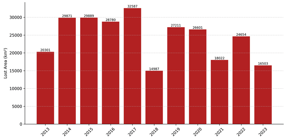
Based on annual records between 2013 and 2023, the total area of vegetation suppressed in the Cerrado biome was systematized, allowing the visualization of accumulated losses year by year, as shown in Figure 7. The series was built from the sum of deforested areas in square kilometers, according to INPE (2024b) organized based on the geographical boundaries defined by IBGE (2019). The data treatment followed criteria of spatial and temporal standardization, enabling the continuous analysis of the annual variation of the vegetation cover suppressed.
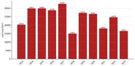
Data reveal oscillations in the amount of deforested area annually in the Cerrado biome, throughout the series analyzed. Although there is no linear pattern of growth or decline, some years stand out for recording higher volumes of loss of native vegetation, while others presented a relative reduction. This year-to-year variation suggests the influence of several conjunctural factors, such as changes in climate regime, land dynamics and intensity of surveillance actions, which can directly impact the rate of forest suppression in each exercise. Thus, it is notable that, between the years of 2013 and 2023, a total of approximately 269,412.14 km2 of vegetation cover was lost in the state of Tocantins.
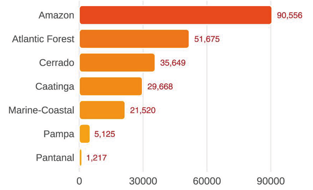
In order to verify the existence of a correlation between plant suppression resulting from deforestation and burning, an analysis of environmental violations registered by IBAMA (2024) was carried out (Figure 8).
The database used was extracted from the infringement files section of the open data platform of IBAMA (2024), respecting the time frame in force at the time of download. Only records whose form status appears as "Drawn and Printed" and whose situation is different from "Canceled", which means that only formalized and valid violations were included in the analysis, were considered. During pre-processing, the data passed through a filter to exclude records with null fields in the variable DS_BIOMAS_ATINGIDOS, which indicates the biomes impacted by each violation. Then applied the burst of records technique, an approach that breaks down compound values - in which two or more biomes were listed in a single field, separated by commas - into multiple lines. This procedure ensured accurate accounting of occurrences by biome, even when a single infringement affects more than one ecosystem.
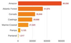
The distribution of infractions by biome in Brazil, in the analyzed interval (2013 and 2023), shows an expressive concentration in the Amazon (largest rainforest in the world, located in the Amazon River basin in South America), which totaled 90,556 occurrences. Next, the Atlantic Forest presented 51,675 violations, while the Cerrado biome accounted for 35,649 records. Caatinga (exclusively Brazilian biome, located in the Northeast region, characterized by semi-arid climate and vegetation adapted to drought), in turn, recorded 29,668 violations, followed by the Coastal and Marine biomes, with 21,520 cases. The region of the Pampa totaled 5,125 violations, and the Pantanal (the largest floodplain in the world, located in the central region of South America, encompassing the Brazilian states of Mato Grosso and Mato Grosso do Sul, as well as parts of Bolivia and Paraguay) presented the lowest number of occurrences among the biomes analyzed, with 1,217 records.
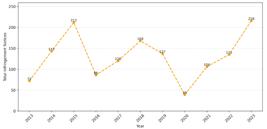
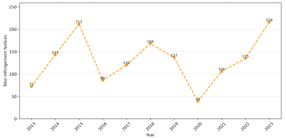
In the analyzed scenario, the evolution of environmental offenses filed in the state of Tocantins between 2013 and 2023 reveals significant variations over the evaluated period (Figure 9). In 2013, 72 notices of infringement were registered, a number that increased to 143 in 2014 and reached the peak of 212 notices in 2015. In the following year, 2016, a significant reduction was observed, with 86 registrations. In 2017, the total rose to 120, maintaining the growth trend in 2018, with 168 cases, and showing a slight decrease in 2019, with 137 records. The year 2020 marked the lowest number in the series, with only 39 infringement notices. From 2021, there is a new high trajectory, with 106 cases in that year, 135 in 2022 and finally 216 infringement cases in 2023, setting the highest value of the analyzed historical series.
The database used was subjected to a rigorous filtering process, considering exclusively the records with form status "Drawn and Printed" and "Cancelled" status equal to "No", in order to ensure that only formalized and active infractions were included in the analysis. The selection was restricted to deforestation and burning records for Tocantins, excluding records drawn in other federal units.
During the pre-processing of the data, relevant inconsistencies were identified, such as incomplete fields and typing errors in the columns of description and encoding of infractions, especially in DES_AUTO_INFRACAO, COD_INFRACAO and DES_INFRACAO. The lack of standardization directly affected the categorization of infrational behaviors, requiring a manual work of screening and review of information. Respecting the margin for human error, the consolidated result is as follows: 17 violations by burning, 1,418 violations by deforestation, making a total of 1,435 violations in the period.
It is important to highlight that the data sheet analyzed (IBAMA, 2024) allows the distinction between natural and legal persons, based on the nature of the document (CPF - Cadastro de Pessoas Físicas (Individual Taxpayer Registry, Brazilian SSN equivalent) and CNPJ - Cadastro Nacional de Pessoa Jurídica (National Registry of Legal Entities, Brazilian EIN equivalent)), through the columns NOME_INFRATOR and CPF_CNPJ_INFRATOR. However, there is no direct classification as to the land or socioeconomic profile of the fined.
In addition, the materialization of infringements deserves consideration. Although the database contains the columns TIPO_MULTA, PATRIMONIO_APURADO and DES_RECEITA, it does not have fields that indicate the procedural outcome of the order, such as payment, cancellation or penalty conversion, which limits the analysis of punitive effectiveness. In addition, the column TIPO_AUTO, although it contemplates the type of self plating, does not detail accessory penalties or compensatory measures applied in the course of the environmental administrative process. Consequently, as noted in the column VAL_AUTO_INFRACAO, the monetary values presented in the base correspond to the initial forecast of fines and do not indicate effective collection, which makes it impossible to estimate the financial income in public coffers resulting from the penalties.
Finally, the existence of the columns EFEITO_MEIO_AMBIENTE and EFEITO_SAUDE_PUBLICA is highlighted. Despite the absence of filling in most records, some cells contain the following classifications: "negligible", "potential", "moderate", "significant" and "weak”.
DISCUSSIONS
Environmental governance in Brazil and the state of Tocantins: challenges and territorial articulations
Environmental governance in Brazil reveals the tension between the vast diversity of natural resources and institutional limitations for their management. The ecological complexity of biomes, added to regional inequalities and fragmentation of public policies, compromises the formulation of guidelines adjusted to local realities (World Bank, 2024; Vargas, 2021). Conceived as a collective process, environmental governance requires integration of knowledge, strengthening federal cooperation and anchoring in technical evidence (Alves; Azevedo, 2023).
The data analyzed throughout the research illustrate this structural asymmetry between ecological potential and institutional capacity. Brazil, which has the second largest forest cover of the planet, with 12.2% of the forests of the world (Figure 1), faces a progressive reduction in native vegetation (Figure 2). This paradox, in which the magnitude of environmental assets contrasts with the persistence of anthropic pressures and administrative weaknesses, illustrates the limits of an environmental governance still predominantly reactive and sectorized.
In the state of Tocantins, these difficulties assume specific contours due to their insertion in ecological zones of transition and in the "deforestation arc", where anthropic pressure intensifies (Silva, 2007). The empirical results confirm this vulnerability: the State presented one of the highest annual deforestation averages in the Cerrado biome in the period between 2013 and 2023, with 22,370 km2 suppressed per year (Figure 3). In addition, it was also observed one of the highest annual average burned area, with 22,458.3 km 2/year (Figure 4), and significant proportional contribution in relation to the total Cerrado biome, both for deforestation and for fires (Figures 5 and 6).
Complementary to the empirical findings, with Regard to the high rate of burning in 2017, pointed out in Figure 5, according to information from the Institute of Man and Environment of the Amazon (Imazon, 2018), the "prolonged drought", which configures an extremely adverse climate scenario, was one of the main factors that contributed to the escalation of the burned area in the state of Tocantins. This intensified behavior is aggravated by the expansion of productive activities under MATOPIBA, which concentrated about 74% of deforestation in the Cerrado biome in 2016-2017, reinforcing the link between anthropogenic pressure and extreme climatic conditions (IPAM, 2017).
These indicators reinforce the need for strategies that recognize the peculiarities of the territory, combining technical knowledge, social participation and integrated planning to promote environmental conservation. Governance, in this context, should be understood as an adaptive and multi-scalar institutional mechanism capable of articulating actions between different levels of government and social sectors. The case of the state of Tocantins, whose prominent participation in the processes of territorial degradation is empirically proven, highlights the urgency of coordinated actions and supported by reliable data to reverse the current trajectory.
Environmental Degradation and the Strategic Role of Brazil in Forest Conservation: global, national and regional scales
Environmental degradation in Brazil manifests itself irregularly, showing different dynamics of use and occupation of the territory, as pointed out by Silva (2007), in his study on the Tocantins-Araguaia basin (Araguaia-Tocantins rivers basin). Such local deforestation and burning processes do not operate in isolation, but reveal global trends of environmental deterioration, making up a growing scenario of ecological vulnerability.
At the international level, the data confirm the strategic relevance of the country for the conservation of the planet (Talamone; Ferraz Junior, 2024; Pnuma, 2019 and World Bank, 2024). This privileged condition, however, coexists with a continuous trend of forest retreat, evidenced by the analyses, which compromises the ecological and climatic balances on a planetary scale.
Environmental preservation, as demonstrated by Kossoy (2018) and FAO (2020), is directly linked to vital ecological functions such as: water regulation, carbon absorption and soil conservation that, once committed, generate impacts that transcend national borders. The empirical analysis reinforces that, although Brazil has a vast environmental heritage (Figure 1), the gap among the commitments undertaken internationally and the effectiveness of internal conservation policies remains significant.
According to Vargas (2021), a significant part of this gap stems from the institutional fragility of the Brazilian environmental management, marked by the fragmentation of competences among federal entities. This limitation is also emphasized by Alves and Azevedo (2023), who point to normative and administrative disarticulation as barriers to the construction of consistent public policies.
At the regional level, data from the state of Tocantins corroborate this diagnosis. The state presented, between 2013 and 2023, alarming indicators of both deforestation (Figure 3) and burning (Figure 4), as well as a significant proportional contribution to vegetation losses in the biome (Figures 5 and 6).
This panorama shows that environmental commitments do not materialize without institutional capacity for planning, control and coordinated action. Environmental governance, in this context, reveals as a necessary condition for the articulation between ecological potential and normative effectiveness. Overcoming the fragmented models therefore requires integrated governance systems, capable of articulating technical evidence, federative cooperation and territorialization of public policies (Alves; Azevedo, 2023; Giovanella et al, 2008).
Thus, in the state of Tocantins, the consolidation of an effective environmental governance system requires, above all, integrated territorial planning, strengthening monitoring mechanisms and accountability, in addition to addressing the institutional gaps that compromise the public response to the increasing degradation.
Variation of the Brazilian Forest Cover (1990-2022): a trend that requires attention
The analysis of the Brazilian forest cover (Figure 2) showed a continuous trend of retraction, with persistent plant suppression over the last decade. Although not abrupt, this process reveals accumulated losses with gradual effects on biodiversity, water regimes and climate stability.
As it can be seen in Table I, there is a more precise evidence of a progressive shrinkage of the Brazilian forest cover over the last three decades. Between 1990 and 2000, the reduction was approximately 6.42%, indicating a significant annual average loss in the context of intensive agricultural expansion and institutional fragility in environmental protection.
In the following decade, between 2014 and 2019, the decline was 1.51%, with a slight slowdown compared to the previous period, possibly related to the consolidation of command and control policies, as well as the intensification of satellite monitoring systems.
Finally, between 2020 and 2022, a cumulative reduction of 0.49% was observed, reflecting the resumption of anthropogenic pressures on forest remnants, especially in the Cerrado and Amazon biomes, due to the weakening of inspection mechanisms. In the cumulative total from 1990 to 2022, Brazilian forest loss was approximately 16.1%, showing a structural decline that reinforces the urgency of integrated conservation policies and territorialized environmental governance.
Despite initiatives such as the Action Plan for the Prevention and Control of Deforestation in the Legal Amazon (PPCDAm), instituted in 2004, challenges to its consolidation still persist. According to the Climate Policy Initiative (2023b), there is a lack of progress in the articulation between efficient supervision and incentives for conservation, a scenario aggravated by institutional fragmentation and the absence of continuous federal cooperation, as occurs in other decentralized social policies (Giovanella et al, 2008).
In this context, environmental governance requires technical and political strengthening, with integrated structures responsive to evidence. According to Vargas (2021) and Alves and Azevedo (2023), the difficulty of articulation between federal entities is a central obstacle to the effectiveness of environmental policies. Reading the historical series reaffirms the urgency of more cohesive and territorialized institutional arrangements.
Burned and deforested area in the Cerrado Biome (2013-2023)
Between the years of 2013 and 2023, the Cerrado biome presented a scenario marked by multiple pressures on its ecosystems, highlighting the recurrence of fires and the advance of deforestation. The distribution of these pressures throughout the historical series reveals heterogeneous spatial patterns, which highlight regional vulnerabilities and indicate limitations in control and prevention mechanisms.
In the case of the state of Tocantins, the data points to one of the highest annual averages of the biome in relation to the burned areas, reaching 22,458.3 km 2/year. At several points in the series, the contribution of the State exceeded the proportional average expected according to its participation in the territorial extension of the Cerrado biome, suggesting the recurrence of intense fire events. This high frequency may be associated with climatic factors, land tenure structure and the presence of large-scale anthropic activities that favor the spread of fire as a vector of environmental degradation.
At the same time, the state of Tocantins also stood out in the deforestation indicators, maintaining an expressive participation in the annual totals recorded for the biome (Figure 6), which is confirmed by the consolidated series (Figure 7). The fluctuations observed over the period indicate the influence of conjunctural factors, such as variability in public environmental control policies, local economic dynamics and intensification of agricultural activities. Studies on the MATOPIBA region - of which the state of Tocantins is part - point to the conversion of native areas into crops, especially soybean, as the main driver of deforestation in the analyzed period IMAFLORA - Instituto de Manejo e Certificação Florestal e Agrícola (Institute of Forestry and Agricultural Management and Certification is a non-profit Brazilian non-governmental organization that promotes the conservation and sustainable use of natural resources, as well as seeking social benefits in the forest (IMAFLORA, 2018).
The consolidation of these analyses allows to clearly delimit the participation of the state of Tocantins in the processes of territorial transformation of the Cerrado biome. The proportions recorded provide technical subsidies for the design of public policies with a territorial focus, aimed at regulating land use, monitoring anthropogenic pressures and monitoring ecosystem services associated with native vegetation.
Environmental Offenses: convergences among human pressure, deforestation, burning and governance
The analysis of consolidated data shows that the Amazon (largest rainforest in the world, located in the Amazon River basin in South America) concentrated the largest number of environmental offenses in the period from 2013 to 2023. This result reflects not only the intensity of anthropic pressures in this biome, but also the presence of more robust institutional structures of supervision. The Cerrado biome and the Atlantic Forest also presented significant volumes of violations, demonstrating relevant environmental challenges in these territories. The biomes of Caatinga (exclusively Brazilian biome, located in the Northeast region, characterized by semi-arid climate and vegetation adapted to drought), the region of Pampa and Pantanal (the largest floodplain in the world, located in the central region of South America, encompassing the Brazilian states of Mato Grosso and Mato Grosso do Sul, as well as parts of Bolivia and Paraguay) recorded relatively smaller numbers of records, which may be associated with factors such as lower population density, different land uses and less comprehensive institutional coverage. Nevertheless, the existence of records even in biomes with less public visibility reinforces the urgency of regionalized strategies for environmental control and accountability.
The spatial distribution of these violations (Figure 8) contributes to the delimitation of priority areas for state action, both in terms of supervision and accountability as well as environmental recovery. The use of an updated and auditable public database, such as that of IBAMA (2024), confers transparency and legitimacy to the analytical process, in addition to offering concrete technical subsidies for the formulation of more effective and territorialized environmental policies.
In the specific case of the state of Tocantins, the data reveal significant fluctuations in environmental offences filed between 2013 and 2023, highlighting the significant increase in registrations between 2021 and 2023, after a minimum point in 2020 - year marked by operational restrictions in public bodies due to the COVID-19 pandemic. This behavior indicates not only variations in surveillance capacity, but also the aggravation of degrading processes such as deforestation and burning in the state territory, as pointed out in the previous figures.
During the treatment of the IBAMA database, operational difficulties were identified related to the absence of an official data dictionary that clarifies the coding logic and the criteria for categorizing infractions. Because of this, it became necessary to manually validate the terms and codes contained in the records. Even with these limitations, an error margin of approximately 5% in the processed data is estimated - an index considered acceptable in quantitative population-based studies, according to Lamattina et al. (2024).
In addition, it was found that there are inconsistencies between the descriptive texts of the offences and the numerical codes associated with them. Although IBAMA provides guidance on the coding structure of its system, it was found that different behaviors, such as deforestation and burning, appeared linked to the same code (Chart 1), which compromised the accuracy in classification. To mitigate this limitation, manual filters were applied based on the occurrence of specific terms in the descriptions, such as "clear", "damage", "explore", "burned" and "fire", in order to recover with greater reliability the records relevant to the analyzed typologies.
The graphical representations derived from this analytical effort reveal not only the pattern of incidence of infractions, but also the structural limitations faced in the categorization stage. The overlapping of codes and terminological inconsistency expose the complexity of the information structure of IBAMA and reinforce the urgent need to improve the quality of administrative records. This challenge, in turn, is directly linked to the assumptions of environmental governance, as discussed by Alves and Azevedo (2023), which highlight the importance of inter-institutional organization and solid information bases for effective and responsive public policies.
When confronted with the indicators of deforestation and fires in the Cerrado biome - particularly in the state of Tocantins, the data from infringement records reveal patterns of spatial and temporal overlap, what points to the recurrent action of degradation agents and gaps in prevention and accountability, which require solid scientific studies. This correlation reinforces the limits of fragmented governance, still poorly articulated between the different federal levels and insufficiently guided by systematized evidence (Vargas, 2021; Alves; Azevedo, 2023).
In addition, the data extracted from the IBAMA (2024) base revealed that, in the state of Tocantins, between 2013 and 2023, 1,435 environmental violations were registered, of which 1,418 were related to deforestation and only 17 to burning. The concentration of these behaviors typified, stumbles on an analytical obstacle: the base does not allow verifying the effective application of penalties, nor their conversion, cancellation or collection. Although there are fields on amounts of expected fines and typology of the order, there are no columns related to the completion of the environmental administrative process or the implementation of compensatory measures. This limitation compromises the estimate of financial return to the treasury or the evaluation of punitive effectiveness, thus hindering the feedback of enforcement strategies.
It was also observed that the base allows to distinguish between individuals and legal entities - based on identification by CPF or CNPJ -, but there is no land or socioeconomic categorization, that makes analyses aimed at differentiated accountability or the application of environmental justice instruments unfeasible. Such gaps reinforce the importance of improving data registration and integration systems, in order to support more precise, transparent and equitable public policies on environmental accountability (Porto et al., 2013).
FINAL CONSIDERATIONS
The results presented throughout this study demonstrate the relevance of the analysis articulated between environmental data, records of violations and foundations of environmental governance to understand the degradation processes in the Cerrado biome. From the mixed methodological approach adopted, it was possible to identify consistent patterns of plant suppression by deforestation and burning, with emphasis on the expressive participation of the state of Tocantins between 2013 and 2023.
The overlap of these pressures, together with the proportional concentration of events, indicates the presence of territorial dynamics associated with structural factors, such as the conversion of native areas into crops, especially for soybean cultivation, as pointed out by studies on the MATOPIBA region. These elements help to understand the persistent role of the state of Tocantins in the processes of environmental transformation of the Cerrado biome and reinforce the need for institutional instruments that operate based on evidence and technical-territorial criteria.
The analysis of the documents of environmental infringement revealed important limitations in the structure of the administrative records of IBAMA, such as the absence of terminological standardization and the overlap of infrational categories. Nevertheless, such data proved to be fundamental to identify priority areas of inspection and regions with recurrence of conduct harmful to the environment.
In this context, environmental governance, as defined by Alves and Azevedo (2023) and Vargas (2021), proves to be a central element for coping with environmental degradation in Brazil. The fragmentation of competences between federal entities and the disarticulation of public policies compromise the ability of the State to respond effectively to anthropogenic pressures affecting biomes.
Thus, it is concluded that the improvement of environmental governance requires, in addition to solid legal frameworks, the technical qualification of monitoring instruments, integration between institutions and the valuation of auditable public data. The articulation between these dimensions is fundamental for the formulation of evidence-based territorial public policies, capable of ensuring environmental conservation, sustainable use of natural resources and accountability for infringing conduct.
As a follow-up, it is recommended that future research focus on the analysis of the outcomes of environmental administrative processes, considering the effectiveness of the penalties applied, the mechanisms for converting fines and recidivism by profile. In addition, comparative studies among different federal units could broaden the understanding of the most effective institutional mechanisms to mitigate environmental degradation in the Cerrado biome.
ACKNOWLEDGMENT
The authors express their sincere gratitude to the Escola Superior da Magistratura Tocantinense (ESMAT) for the invaluable institutional support provided for the translation of the article "Environmental Governance and Degradation Dynamics in the Cerrado - Brazilian Biome: Empirical and Institutional Evidence in the State of Tocantins" into English. This collaboration was essential to enable the international submission of this research.
DATA AVAILABILITY
The data that support the findings of this study can be made available, upon reasonable request, from the corresponding author [Silvânia Gonçalves de Carvalho].
References
-
ALVES, R. A.; AZEVEDO, A. M. Governança ambiental e desafios socioambientais contemporâneos: uma análise da evolução da gestão pública. Revista de Desenvolvimento Econômico - RDE, Salvador, 2023. http://dx.doi.org/10.36810/rde.v2isaru20.8774
» https://doi.org/10.36810/rde.v2isaru20.8774 -
Banco Mundial. Forest area (sq. km). DataBank, 2024. Disponível em: https://databank.worldbank.org/reports.aspx?source=2&series=AG.LND.FRST.K2&country=# Acesso em: 01 mar. 2025.
» https://databank.worldbank.org/reports.aspx?source=2&series=AG.LND.FRST.K2&country=# -
BRASIL. Decreto nº 9.073, de 5 de junho de 2017. Disponível em: https://www.planalto.gov.br/ccivil_03/_Ato2015-2018/2017/Decreto/D9073.htm Acesso em: 1 abr. 2025.
» https://www.planalto.gov.br/ccivil_03/_Ato2015-2018/2017/Decreto/D9073.htm -
CLIMATE POLICY INITIATIVE. O efeito dominó da Amazônia: como o desmatamento pode desencadear uma degradação generalizada. São Paulo: CPI, 2023a. Disponível em: https://www.climatepolicyinitiative.org/pt-br/publication/o-efeito-domino-da-amazonia-como-o-desmatamento-pode-desencadear-uma-degradacao-generalizada/ Acesso em: 1 abr. 2025.
» https://www.climatepolicyinitiative.org/pt-br/publication/o-efeito-domino-da-amazonia-como-o-desmatamento-pode-desencadear-uma-degradacao-generalizada/ -
CLIMATE POLICY INITIATIVE. Combate ao desmatamento ilegal: fortalecimento do comando e controle é fundamental. São Paulo: CPI, 2023b. Disponível em: https://www.climatepolicyinitiative.org/publication/combating-illegal-deforestation/white-paper-combate-ao-desmatamento-ilegal-fortalecimento-do-comando-e-controle-e-fundamental-2/ Acesso em: 1 abr. 2025.
» https://www.climatepolicyinitiative.org/publication/combating-illegal-deforestation/white-paper-combate-ao-desmatamento-ilegal-fortalecimento-do-comando-e-controle-e-fundamental-2/ -
DERMEVAL, D.; COELHO, J. A. P. D. M.; BITTENCOURT, Ig I. Mapeamento Sistemático e Revisão Sistemática da Literatura em Informática na Educação. In: BITTENCOURT, Ig I. et al. (Org.). Metodologia de Pesquisa Científica em Informática na Educação: Abordagem Quantitativa. Brasília: Sociedade Brasileira de Computação, 2020. Disponível em: https://ceie.sbc.org.br/metodologia/index.php/livro-2/ Acesso em: 29 mar. 2025.
» https://ceie.sbc.org.br/metodologia/index.php/livro-2/ -
FOOD AND AGRICULTURE ORGANIZATION OF THE UNITED NATIONS (FAO). The State of Food and Agriculture: Overcoming water challenges in agriculture. Rome: 2020. Disponível em: https://www.fao.org/interactive/state-of-food-agriculture/2020/en/ Acesso em: 11 abr. 2025.
» https://www.fao.org/interactive/state-of-food-agriculture/2020/en/ -
GOOGLE SCHOLAR. 2024. Disponível em: https://scholar.google.com.br/ Acesso em: 11 abr. 2025.
» https://scholar.google.com.br/ -
GIOVANELLA, L.; ESCOSTEGUY, C. C.; MENDES, A.; VIEIRA DA SILVA, L. M. (orgs.). Políticas e sistemas de saúde no Brasil. 2. ed. Rio de Janeiro: Editora Fiocruz, 2008. Disponível em: https://books.scielo.org/id/c5nm2 Acesso em: 04 jul. 2025.
» https://books.scielo.org/id/c5nm2 -
IBAMA - Instituto Brasileiro do Meio Ambiente e dos Recursos Renováveis. Dados abertos - Fiscalização: Autos de infração. 2024. Disponível em: https://dadosabertos.ibama.gov.br/dataset/fiscalizacao-auto-de-infracao Acesso em: 29 mar. 2025.
» https://dadosabertos.ibama.gov.br/dataset/fiscalizacao-auto-de-infracao -
IBAMA - INSTITUTO BRASILEIRO DO MEIO AMBIENTE E DOS RECURSOS NATURAIS RENOVÁVEIS. Resposta ao Pedido de Acesso à Informação - Processo SEI nº 02303.005265/2025-81. Brasília, DF. Disponível em: https://buscalai.cgu.gov.br/PedidosLai/DetalhePedido?id=8504840 Acesso em: 29 mar. 2025.
» https://buscalai.cgu.gov.br/PedidosLai/DetalhePedido?id=8504840 -
IBGE - Instituto Brasileiro de Geografia e Estatística. Biomas e Sistema Costeiro-Marinho do Brasil - PGI. 2019. Disponível em: https://www.ibge.gov.br/apps/biomas/#/home Acesso em: 29 mar. 2025.
» https://www.ibge.gov.br/apps/biomas/#/home -
IBGE - Instituto Brasileiro De Geografia e Estatística. Cidades e Estados. Tocantins (código: 17). 2024. Disponível em: https://www.ibge.gov.br/cidades-e-estados/to.html Acesso em: 06 jul. 2025.
» https://www.ibge.gov.br/cidades-e-estados/to.html -
IMAFLORA - Instituto de Manejo e Certificação Florestal e Agrícola. Relatório mapeia em detalhes a cadeia produtiva da soja e contribui para a transparência no setor. 2018. Disponível em: https://imaflora.org/noticias/relatorio-mapeia-em-detalhes-cadeia Acesso em: 1 abr. 2025.
» https://imaflora.org/noticias/relatorio-mapeia-em-detalhes-cadeia -
IMAZON - Instituto Do Homem E Meio Ambiente Da Amazônia. Brasil termina 2017 com número recorde de queimadas desde 1999. Belém, 11 jan. 2018. Disponível em: https://imazon.org.br/imprensa/brasil-termina-2017-com-numero-recorde-de-queimadas-desde-1999/ Acesso em: 06 jul. 2025.
» https://imazon.org.br/imprensa/brasil-termina-2017-com-numero-recorde-de-queimadas-desde-1999/ -
INPE - Instituto Nacional de Pesquisas Espaciais. Monitoramento do Desmatamento no Brasil por Satélite. São José dos Campos: INPE, 2024a. Disponível em: https://terrabrasilis.dpi.inpe.br/app/map/deforestation Acesso em: 28 mar. 2025.
» https://terrabrasilis.dpi.inpe.br/app/map/deforestation -
INPE - Instituto Nacional de Pesquisas Espaciais. Sistema de monitoramento da cobertura vegetal - Bioma Cerrado. 2024b. Disponível em: https://terrabrasilis.dpi.inpe.br/ Acesso em: 1 abr. 2025.
» https://terrabrasilis.dpi.inpe.br/ -
IPAM - Instituto de Pesquisa Ambiental da Amazônia. Nota sobre o anúncio de desmatamento no Cerrado em 2016 e 2017. IPAM Amazônia, 2017. Disponível em: https://ipam.org.br/nota-sobre-o-anuncio-de-desmatamento-no-cerrado-em-2016-e-2017/ Acesso em: 04 jul. 2025.
» https://ipam.org.br/nota-sobre-o-anuncio-de-desmatamento-no-cerrado-em-2016-e-2017/ -
KOSSOY, A. Qual é a importância do Brasil no Acordo do clima de Paris. ONU Brasil, 19 nov. 2018. Disponível em: https://brasil.un.org/pt-br/81635-artigo-qual-%C3%A9-import%C3%A2ncia-do-brasil-no-acordo-do-clima-de-paris Acesso em: 1 abr. 2025.
» https://brasil.un.org/pt-br/81635-artigo-qual-%C3%A9-import%C3%A2ncia-do-brasil-no-acordo-do-clima-de-paris -
LAMATTINA, A. D. A.; PERALTA, M. C.; PAULINO, C. E.; OLIVEIRA, D. D. S. Quantificando Realidades: Técnicas de Pesquisa Quantitativa. Brasília: Editora MultiAtual, 2024. Disponível em: https://educapes.capes.gov.br/bitstream/capes/869503/2/Quantificando%20Realidades%20T%C3%A9cnicas%20de%20Pesquisa%20Quantitativa.pdf Acesso em: 30 mar. 2025.
» https://educapes.capes.gov.br/bitstream/capes/869503/2/Quantificando%20Realidades%20T%C3%A9cnicas%20de%20Pesquisa%20Quantitativa.pdf -
LEAL, G. S.; SILVA, D. A. O.; SOPELETE, M. C. Conceitos básicos de bioestatística. In: MINEO, J. R. (Org.). Introdução à estatística: análise exploratória de dados com o software R. Uberlândia: EDUFU, 2010. Disponível em: https://books.scielo.org/id/wh35j/pdf/mineo-9788570785237-07.pdf Acesso em: 31 mar. 2025.
» https://books.scielo.org/id/wh35j/pdf/mineo-9788570785237-07.pdf -
MAPBIOMAS - Mapeamento Anual da Cobertura e Uso do Solo no Brasil. Cicatrizes de Fogo (Coleção 3). 2024a Disponível em: https://brasil.mapbiomas.org/estatisticas/ Acesso em: 28 mar. 2025.
» https://brasil.mapbiomas.org/estatisticas/ -
MAPBIOMAS - Mapeamento Anual da Cobertura e Uso do Solo no Brasil. MATOPIBA passa a Amazônia e assume a liderança do desmatamento no Brasil. 2024b. Disponível em: https://brasil.mapbiomas.org/2024/05/28/matopiba-passa-a-amazonia-e-assume-a-lideranca-do-desmatamento-no-brasil/ Acesso em: 04 jul. 2025.
» https://brasil.mapbiomas.org/2024/05/28/matopiba-passa-a-amazonia-e-assume-a-lideranca-do-desmatamento-no-brasil/ -
PORTO, M. F. S.; PACHECO, T.; LEROY, J. P. Injustiça ambiental e saúde no Brasil: o mapa de conflitos. Rio de Janeiro: Editora Fiocruz, 2013. Disponível em: https://books.scielo.org/id/468vp/pdf/porto-9788575415764.pdf Acesso em: 06 jul. 2025.
» https://books.scielo.org/id/468vp/pdf/porto-9788575415764.pdf -
PNUMA - Programa das Nações Unidas para o Meio Ambiente. Brasil possui entre 15% e 20% da diversidade biológica mundial. ONU News, 22 mar. 2019. Disponível em: https://news.un.org/pt/story/2019/03/1662482 Acesso em: 9 nov. 2024.
» https://news.un.org/pt/story/2019/03/1662482 -
SILVA, L. A. G. C. Biomas presentes no Estado do Tocantins. Brasília: Câmara dos Deputados, Consultoria Legislativa, 2007. Disponível em: https://bd.camara.leg.br/bd/items/16ed57de-03d8-4f66-8ee0-58766e19de43/full Acesso em: 4 abr. 2025.
» https://bd.camara.leg.br/bd/items/16ed57de-03d8-4f66-8ee0-58766e19de43/full -
SCIELO - Scientific Electronic Library Online. 2025. Disponível em: https://www.scielo.br/ Acesso em: 31 mar. 2025.
» https://www.scielo.br/ -
TALAMONE, R.; FERRAZ JUNIOR. A complexa geografia da água no Brasil e no mundo. Jornal da USP, 18 mar. 2024. Disponível em: https://jornal.usp.br/campus-ribeirao-preto/a-complexa-geografia-da-agua-no-brasil-e-no-mundo/ Acesso em: 9 nov. 2024.
» https://jornal.usp.br/campus-ribeirao-preto/a-complexa-geografia-da-agua-no-brasil-e-no-mundo/ -
UNIVERSIDADE FEDERAL DE SÃO CARLOS. Biblioteca Comunitária. Web of Science. São Carlos. 2024. Disponível em: https://www.bco.ufscar.br/servicos-informacoes/web-of-science Acesso em: 18 mar. 2024.
» https://www.bco.ufscar.br/servicos-informacoes/web-of-science -
VALLE, P. R. D.; FERREIRA, J. D. L. Análise de conteúdo na perspectiva de Bardin: contribuições e limitações para a pesquisa qualitativa em educação. Educar em Revista, 2024. https://doi.org/10.1590/0102-469849377
» https://doi.org/10.1590/0102-469849377 -
VARGAS, D. L. Na contramão da sustentabilidade: a pauta da governança ambiental no Brasil. Colóquio - Revista do Desenvolvimento Regional, Taquara, 2021. https://doi.org/10.26767/2026
» https://doi.org/10.26767/2026
-
ASSOCIATE EDITOR
Silvio Carlos Rodrigues - 0000-0002-5376-1773

 Source: Elaborated by the authors (2025) from
  Source: Elaborated by the authors (2025) from
  Source: Elaborated by the authors (2025) from
  Source: Elaborated by the authors (2025) from
  Source: Elaborated by the authors (2025) from
  Source: Elaborated by the authors (2025) from
  Source: Elaborated by the authors (2025) from
  Source: Elaborated by the authors (2025) from
  Source: Elaborated by the authors (2025) from