
 How Much Green is Left in a Metropolis? A Study on the Remaining Vegetation Cover in Fortaleza, Ceará, Brazil
Abstract
The expansion of human activities has caused a significant loss of biodiversity globally, with anthropogenic land uses rapidly expanding and urban areas growing quickly, resulting in deforestation and fragmentation of natural ecosystems. The city of Fortaleza, an example of this phenomenon, has faced disorganized urban growth, loss of vegetation cover, and deep socio-environmental challenges throughout its history. This resulted in the loss of most of the municipality's vegetation cover and the fragmentation of the remaining areas. This study aims to quantify the remaining vegetation fragments in Fortaleza, map the municipality's original ecosystems, and map the remaining native vegetation. Using geomorphology maps and correlating the typical vegetation types in each original landscape unit, we mapped the city's native ecosystems, identifying seven categories: coastal grasslands, dune ecosystems, vegetation of coastal tablelands, mangroves, riparian forests, caatinga, and dry forests. Using high-resolution satellite images and the maximum likelihood method, we found that 62% of the territory is urbanized, and much of the remaining areas are already devoid of vegetation. Only about 16% of the municipality's surface still has vegetation fragments. The preservation of vegetation cover and urban biodiversity is a fundamental goal for the sustainable development of cities, providing various ecosystem services, such as maintaining fauna and preventing floods, especially in the context of climate emergency. The study identified remaining natural areas and locations requiring legal protection. We suggest the creation of Conservation Units, Urban Parks, and green areas connecting existing fragments, as a vital goal for the sustainability of Fortaleza and the conservation of urban biodiversity.
Keywords:
Urban green areas; Vegetation fragments; Biodiversity loss; Urbanization
Resumo
A expansão das atividades humanas tem causado uma perda significativa de biodiversidade globalmente, com os usos antrópicos do solo se expandindo fortemente e as zonas urbanas crescendo rapidamente, resultando em desmatamento e fragmentação de ecossistemas naturais. A cidade de Fortaleza, -um exemplo desse fenômeno, enfrentou ao longo de sua história crescimento urbano desordenado, perda de cobertura vegetal e desafios socioambientais profundos. Isso resultou na perda da maior parte da cobertura vegetal do município e na fragmentação das áreas remanescentes. Este estudo busca quantificar o quanto sobrou de fragmentos de vegetação na cidade de Fortaleza, mapear os ecossistemas originais do município e mapear a vegetação nativa restante. Usando mapas de geomorfologia e a correlação do tipo de vegetação típico em cada unidade de paisagem original, mapeamos os ecossistemas nativos da cidade, identificando sete categorias: campos de praia, dunas, tabuleiros costeiros, manguezais, matas ciliares, caatinga e mata seca. Usando imagens de satélite de alta resolução e o método da máxima verossimilhança, verificamos que 62% do território está urbanizado e boa parte das áreas restantes já estão desprovidas de vegetação. Apenas cerca de 16% da superfície do município ainda tem fragmentos de vegetação. A preservação da cobertura vegetal e da biodiversidade urbana é uma meta fundamental para o desenvolvimento sustentável das cidades, além de prover diversos serviços ecossistêmicos, como manutenção de fauna e prevenção de enchentes, especialmente em um contexto de emergência climática. O estudo identificou áreas naturais remanescentes e locais necessitando de proteção legal. Fazemos sugestões para a criação de Unidades de Conservação, Parques Urbanos e áreas verdes conectando fragmentos existentes, como objetivo vital para a sustentabilidade de Fortaleza e a conservação da biodiversidade urbana.
Palavras-chave:
Áreas verdes urbanas; Fragmentos de vegetação; Perda de biodiversidade; Urbanização
INTRODUCTION
The expansion of human activities, such as agriculture, livestock farming and urbanization, has been the main cause of biodiversity loss over the last few centuries (McDonald et al., 2020; Vitousek et al., 1997). This impact is especially evident in Western Europe, where there has been a significant reduction in biodiversity, estimated at between 20% and 30% (Newbold et al., 2015). This problem worsened after the Industrial Revolution due to predatory exploitation of natural resources (Steffen et al., 2007; Vitousek et al., 1997). History shows a continuous conflict between human development and the environment, resulting in widespread deforestation, loss of vegetation cover and species extinction, a process that intensified from the great empires to the 20th century (Bologna; Aquino, 2020).
We are currently witnessing rapid population growth around large urban areas (Farias et al., 2017). According to the World Urbanization Prospects - 2022 report (UN, 2022), urban areas are expanding twice as fast as population growth, and by 2050, two-thirds of the world's population will live in urban areas. Tropical and subtropical forests are suffering large-scale deforestation due to commercial agriculture, followed by subsistence agriculture, urban expansion, infrastructure and mining (FAO, 2020).
Since the 20th century, Brazil has undergone profound transformations, moving from a predominantly rural country to an urban one. This process of creating cities was driven by industrialization and strong state intervention, through the concentration of public investment and capital in urban areas, which generated an immense movement of city-building that concentrates people and various socio-environmental problems (Maricato, 2001; Santos, 2008).
In this context, the city of Fortaleza's urban growth was driven by the concentration of public investment and capital in the seat of local political power, to the detriment of the interior areas; the low complexity and complementarity of the network of urban centers in Ceará, making Fortaleza the main place to receive the rural exodus as a result of the constant droughts that occurred in the interior areas of the state (Bomtempo, 2015; Costa, 2008; Silva, 2000). From 1950 to 1970 alone, Fortaleza's population grew from 213,000 to more than 850,000 inhabitants, beginning the 21st century with more than two million inhabitants and currently having almost 2.5 million (IBGE, 2004; IBGE, 2023).
The city expanded without planning and lacked infrastructure and services, with a large part of the population living informally, sheltered in precarious settlements and distant neighborhoods (Costa; Amora, 2015). At the same time, the municipality lost its vegetation cover, which was the most modified element during this period (Cortez, 2000).
Rapid urbanization, especially in large cities, is having a negative impact on environmental, social and economic aspects. The disappearance of green areas and the suppression of vegetation fragments and permanent preservation areas in urban areas harms the population's quality of life and compromises efforts to conserve biodiversity (Nucci, 2008). The few areas of vegetation that resist urbanization are generally found as isolated fragments in the urban landscape, which results in a significant loss of biodiversity due to deforestation and fragmentation (Rotermund, 2012).
Although little is covered by research, fragments of vegetation in urban areas often represent the last remnants of green areas in a city and are fundamental for maintaining local biodiversity (Freire et al. 1990; Moro et al. 2011; Salles; Schiavini, 2007; Tanus et al. 2012). As well as making the environment more psychologically and aesthetically pleasing, and improving the health of the population, vegetated urban areas reduce air and noise pollution, help conserve water and soil, feed and help fauna survive, mitigate heat islands, promote carbon reserves, among many other environmental services and functions (Milano; Dalcin, 2000; Souza et al, 2013; Sonntag-Öström et al., 2014; Ren et al., 2018; Silva; et al., 2020; Nascimento et al., 2020).
Many cities seek to preserve biodiversity by legally protecting large natural areas within their territory. A remarkable example is the large conservation areas within the urban fabric of the city of Rio de Janeiro, with areas such as the Parque Nacional Floresta da Tijuca (Tijuca Forest National Park), Parque Estadual da Pedra Branca (Pedra Branca State Park), Parque Natural Municipal da Serra do Mendanha (Serra do Mendanha Municipal Natural Park) and others in Rio de Janeiro, as well as conservation units (CU’s) in several other large Brazilian cities, such as São Paulo (e.g. Parque Estadual Fontes do Ipiranga , Serra do Mar and Cantareira - Fontes do Ipiranga, Serra do Mar and Cantareira State Park, among other green areas), Natal ( Parque Estadual Dunas do Natal - Dunas do Natal State Park), Fortaleza (Parque Estadual do Cocó - Cocó State Park) and several other cities.
The strategy of creating specially protected areas for nature conservation in urban areas depends on mapping where these areas are, identifying their extent, identifying the types of ecosystems that have survived urban sprawl, and mapping sites with native vegetation that have not yet been protected and could be preserved. In addition, it is essential to understand how the different original ecosystems have been affected by urban sprawl, quantify what has already been lost and determine what can still be conserved in each municipality.
In this study, we explore these issues in the context of Fortaleza, the fourth most populous city in Brazil, the capital with the highest population density, and one of the country's main metropolises. The aim of the work was to identify and classify Fortaleza's original ecosystems, documenting the ecosystems that existed before urban expansion and mapping their original extent, and to indicate how much is left of each of the natural ecosystems. In addition, the aim is to quantify the area that has been urbanized, the vegetation that has been degraded and the native vegetation that still exists in the metropolis of Fortaleza.
METHODOLOGY
Study area
The city of Fortaleza, capital of the state of Ceará, covers an area of 312 km². It is the fourth most populous municipality in the country, with almost 2.5 million inhabitants, and also the one with the highest population density (IBGE, 2023). Located in the coastal region of Ceará, it has 34 km of beaches, being surrounded to the south by pre-littoral residual massifs, and its western and eastern limits marked by the presence of the mouth of the Ceará River and the mouth of the Pacoti River, respectively (Fortaleza, 2020). Humidity and rainfall are considered moderate, allowing the city to be characterized as having a hot sub-humid tropical climate (IPECE, 2018; Petalas; Mota, 2013). The relief patterns are manifested in the predominance of Cenozoic sedimentary cover, with the occurrence of crystalline terrains and reliefs carved out of Tertiary volcanic-alkaline rocks in some stretches (Brandão, 1998; CPRM, 2015; Santos, 2015). The municipality's vegetation is mostly part of the Vegetation Complex of the Coastal Zone (forests, savannas and shrublands on the coastal tablelands, plus beach grasslands), as well as mangroves and riverine forests (carnaubais), on the banks of the rivers (Funceme, 2018; IPECE, 2018).
Drawing up the Original Vegetation Map of the Municipality of Fortaleza
In this study, we created a map representing the approximate distribution of natural ecosystems in Fortaleza. The mapping of the original natural ecosystems of the city was based on the geomorphological classification of Santos (2015) for the area of the municipality and on the Zoneamento Ecológico Econômico da Zona Costeira do Estado do Ceará (Ecological-Economic Zoning of the Coastal Zone of the State of Ceará) (ZEEC), prepared by the Secretaria Estadual de Meio Ambiente (State Department for the Environment) (SEMA). These works have cartographic bases at scales of 1:10,000 and 1:25,000 (Ceará, 2021). These maps were used to identify the municipality's main geomorphologies. Through field surveys of the remaining ecosystems and the relationship already documented in the literature between the landforms and ecosystems associated with each geomorphological unit for Ceará, we produced a map that roughly represented the municipality's natural ecosystems (Chart 1).
The geomorphological classification covered the entire length of the municipality and made it possible to map the types of natural ecosystems that existed in each geomorphological unit, based on the correlation between types of vegetation and geomorphology established by Moro et al. (2015) for Ceará, in addition to fieldwork, visiting the different remaining ecosystems inside the city. This made it possible to estimate the size of the area of each ecosystem, approximating the original natural conditions of the municipality before urban expansion.
It is important to note that, due to intense human activities that have altered the relief and water resources, such as landfilling of lagoons and lakes, canalization of rivers and changes in the coastline, establishment of coastal spikes and landfills on beaches, our map is an approximation of the natural ecosystems of Fortaleza’s site, not a completely precise reconstitution of the initial ecosystem. In a city like Fortaleza, rivers have been canalized, lagoons have been landfilled, and beach lines have been modified. It is therefore not possible to obtain a completely accurate map of the original ecosystems before the presence of the city on the site. However, the geomorphological map generated represents the best current representation of the original natural conditions in Fortaleza, recognizing that some areas, such as Shorelines and aquatic ecosystems, have suffered irreversible changes.
Despite this, we used the correspondence observed in the field and in the literature (Moro et al., 2015) to create, from the geomorphological map of Fortaleza, an approximate map of the municipality's original natural ecosystems, generating a shapefile that is being made available for download and use along with this work (check the supplementary material at: https://doi.org/10.6084/m9.figshare.28802192).
Land Use and Land Cover Map
Satellite images and techniques based on supervised classification methods were used to analyze land use and land cover in Fortaleza (Rotermund, 2012; Sousa et al., 2020). For the classification, it was decided to adopt the Sentinel 2A satellite image, captured by the sensor on 07/22/2020, acquired through the platform of the Instituto Nacional de Pesquisas Espaciais (National Institute for Space Research) (INPE). The satellite image was reprojected to SIRGAS 2000 Datum in UTM projection, 24S zone. QGIS 3.16.13 software (QGIS, 2021) was used to handle the image, and the satellite image raster was cut out using the shapefile layer corresponding to the official perimeter of the municipality of Fortaleza, obtained from Instituto Brasileiro de Geografia e Estatística (IBGE) (Brazilian Institute of Geography and Statistics). Land use classification was carried out automatically with the help of the Dzetsaka Classification Tool plugin, using the maximum likelihood method, which is widely recognized in supervised classification (Fitz, 2008). This method belongs to the "pixel by pixel" approach, which analyzes the spectral information of each pixel in isolation to find homogeneous regions. The minimum mapped area corresponds to 0.00000004 km², with no defined minimum threshold for polygon size.
Subsequently, the reliability of the data generated was assessed using the Accuracy tool, seeking a minimum accuracy of 85%, according to Metzger (2006). The stratified random sampling model was used, in which the distribution of points was done randomly within each stratum, while the number of samples per stratum was defined manually, considering their proportion of area to ensure balanced representation. A total of 110 control points were used. Initially, nine cover classes were defined, which were grouped into six types of land use (Chart 2).
Access to raw data and research-generated files should be provided openly to meet the requirements of Open Science (Moro et al., 2022). Accordingly, adhering to these principles, we openly provide the shapefiles, high-resolution maps, and the files created in this study, which can be freely accessed through the Figshare scientific repository at the following link: https://doi.org/10.6084/m9.figshare.28802192.
RESULTS
Classification of ecosystems and original vegetation in the municipality of Fortaleza
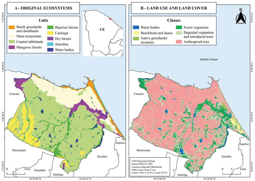
Based on the analysis carried out, it was possible to identify the existence of seven types of natural ecosystems in what is now the municipality of Fortaleza. The ecosystems mapped were: Beach grassland and shrubland (deflation surface), dune ecosystem (mobile dunes, fixed dunes and paleodunes), coastal tableland vegetation (coastal tableland, regardless of whether the original vegetation was forest, shrubland or savannah), mangrove swamp (Estuarine plain), riparian forest (fluvial, lacustrine and fluviolacustrine plains), caatinga (sertaneja depression or crystalline uplands) and dry forest (residual volcanic surfaces). With this, we generated the most detailed map we are aware of representing what the original natural ecosystems of the municipality of Fortaleza would have been (Figure 1-A). In addition to the classification of vegetation, we can also see the mapping of the Shoreline and bodies of water, which, due to the long history of alterations, with the filling in of lagoons, lakes and ponds, changes in the course of rivers, the construction of ports, jetties, spikes, the installation of coastal embankments and other alterations, could not be determined with much precision in relation to their original disposition before human intervention.
The classes of natural ecosystems with the greatest extent within the municipality's boundaries were: coastal tableland vegetation (originally mostly forests and savannas), which occupied 57% of the municipality's territory, the dune ecosystem, which covered 16% of the area of Fortaleza, and the caatinga, which corresponded to 9% of the municipality's total area (Table 1). The caatinga had a sizable patch to the southwest and other small patches to the southeast in the transition between the sedimentary Barrier Formation and the crystalline Sertaneja Depression. The Dry Forest, on the other hand, had a small area in the southeast of the municipality, on the old remains of the Ancuri volcanic ridge. The Mangroves (Estuarine plain) can be found near the mouths of the city's main rivers: the Ceará River to the west; the Cocó River to the east; and a little further east, on the border between the municipalities of Fortaleza, Eusébio and Aquiraz, the Pacoti River. The Riparian Forest (River Plains), on the other hand, interpenetrates several other units, following the course of rivers, streams, ponds, lakes and lagoons (Figure 1). With this, we calculated the total area occupied by each type of ecosystem in what is now the official political boundary of the municipality of Fortaleza (Table 1).
Land Use and Land Cover Classification
In the analysis of land use and cover in Fortaleza, seven cover classes were mapped. The largest class was urbanized/anthropized areas, covering 197 km² (around 63% of the territory), including buildings and roads. Other categories included degraded vegetation and introduced trees (20%), forest vegetation (11%), bodies of water (2%), native grassland vegetation (0.5%), and non-urbanized dunes and Shoreline (1.5%) (Table 2).
The supervised classification achieved 88% accuracy, indicating robust land-use analysis. However, manual review revealed errors in certain classes, such as in the identification of Bodies of Water (65%) and Dunes/Beaches (20%), which had lower accuracy rates. In the case of water bodies, the significant presence of aquatic vegetation influenced the classification, promoting interactions with other vegetation classes and increasing the complexity of the analysis. Similarly, the Dunes and Beach areas showed strong interaction with regions of exposed soil, making it difficult to distinguish between these classes and impacting on classification accuracy. The final manual adjustments were essential to reduce these inaccuracies and make the analysis more reliable.
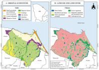
(A) Approximate map of the original natural ecosystems of the municipality of Fortaleza, coastal region of the state of Ceará, Brazil. (B) Map of land use and land cover according to the supervised classification method of the municipality of Fortaleza, CE. The high-resolution maps can be downloaded from the article's digital supplements
The lost and remaining area of each vegetation class in Fortaleza was calculated based on the new classification of vegetation types and land use (Table 3). This included an analysis of the loss of natural vegetation cover due to urbanization and vegetation degradation (deforested areas with degraded vegetation). This made it possible to determine the total area already deforested (consolidated urbanized areas and unbuilt deforested areas), resulting in the remaining area of native vegetation in the municipality.
The ecosystems that lost the most area to anthropization were: the crystalline caatinga (77%), the dune ecosystems (74%) and the coastal tablelands (68%). The dry forest environment (2%) lost the least area to anthropization, but it's worth noting that this type of vegetation in Fortaleza has a very small occurrence, restricted to ancient volcanic surfaces such as the Ancuri ridge. Situated on the southeastern fringe of Fortaleza, and of volcanic origin, the Ancuri mountain range is the steepest and sharpest relief in the municipality. In addition to the high slope, the existence of the treated water pumping station that supplies Fortaleza contributes to the protection of this vegetation.
The natural ecosystems that showed the most loss of natural vegetation cover through conversion into degraded vegetation (i.e. they have been cleared but not yet consolidated with buildings) were: riparian forest (39% loss), coastal tablelands (22%) and the crystalline caatinga (17%). On the other hand, in the coastal tablelands and dune areas, there was a strong urbanization process in the past, which has already consolidated urban infrastructures on the land. Finally, it was possible to observe that the environments with the largest remaining areas were: dry forest (85%), mangroves (75%) and riparian forest (39%). The environment with the least remaining area was the caatinga (4%). It is worth noting that the water bodies class includes water bodies that have been converted to other uses or altered, such as those that may have dried up and become occupied by vegetation.
Overall, the city of Fortaleza has a total modified area of 83% of the municipality's extension, with 196.9 km² degraded by direct urbanization and 64.8 km² by deforested areas that have not yet been paved or built on. In total, 261 km² of Fortaleza's total area has already been deforested and only 51 km² remain. As a result, we still have approximately 16% of the municipality's extension as remaining native areas, although most of them have some degree of degradation, and in several cases there is considerable degradation, such as pollution from effluent dumping, garbage dumping, invasion by invasive exotic species, anthropogenic fires, among other impacts.
DISCUSSION
The Coastal Tablelands stand out for being the class that occupies the largest area of the municipality's territory, and can present different types of vegetation. In Fortaleza, part of the territory of the tablelands was mostly covered by semi-deciduous tableland forests, and part by coastal savannas (for example, in the Área de Relevante Interesse Ecológico - ARIE - Professor Abreu Matos (Area of Relevant Ecological Interest Professor Abreu Matos) - Moro et al., 2011).
Despite the limitations of the method, with the help of the literature and field visits to the sites, it was possible to map part of the areas with grassland or savannah vegetation, including an area of coastal savannah already identified in the literature (Moro et al., 2011). This area is part of the sustainable use conservation unit, ARIE Prof. Abreu Matos, located in the Cambeba district. Although the area is already protected, it is possible to see some small green fragments that have been left out of the ARIE polygon. These areas should be integrated into the CU's polygonal, since the ARIE Prof. Abreu Matos, besides being small, is an important remnant of coastal savanna in Fortaleza and is an example of resistance to the process of urban expansion in the city of Fortaleza, given that it is surrounded by an anthropized matrix.
Other areas that have been well affected by the advance of the urbanization process are the field and beach shrubs, which are highly threatened by anthropogenic impacts ranging from the construction of houses to the sealing of the soil for the implementation of roads (Fortaleza, 2020). Restinga vegetation, common to these environments, is an ecosystem protected by various legal instruments such as the Atlantic Forest Law and Conselho Nacional do Meio Ambiente (CONAMA) (National Environmental Council) Resolution 303/2002. Some areas of this physiognomy were mapped manually and also identified as grassland vegetation. The fragments are located near the Parque Estadual do Cocó (Cocó State Park), in the Praia do Futuro II neighborhood, and the others are part of the Parque Natural Municipal das Dunas de Sabiaguaba (Sabiaguaba Dunes Municipal Natural Park). The dune ecosystem, as presented here, was a grouping of mobile dunes, fixed dunes and paleodunes, and it is worth noting that the Restinga vegetation is typical of Prairie Fields and Shrubs and Fixed Dunes.
A study carried out by Pinheiro (2009) presented conclusions that are in line with the results obtained here, which identified major losses in the dune environments of Fortaleza. His work analyzed the dune environments found at Futuro beach, Sabiaguaba beach and areas to the west of the city, where the fixed dunes were mostly lost and the mobile dunes also showed considerable loss. Sabiaguaba beach was the only place that still had representative values of mobile and fixed dunes remaining, 58% and 42%, respectively (Pinheiro, 2009). It is known that the Sabiaguaba Dunes currently represent the main dune remnant in the city of Fortaleza. Comparing the results found by Pinheiro (2009) for the year 1958 with the data found here, it can be said that the Sabiaguaba dunes have lost around 69% of their area.
The dune ecosystems at Sabiaguaba beach are now protected within conservation units, such as the Parque Natural Municipal das Dunas de Sabiaguaba (Sabiaguaba Dunes Municipal Natural Park) and the Área de Proteção Ambiental da Sabiaguaba (Sabiaguaba Environmental Protection Area). Although they are protected by law, they suffer from serious impacts, from vehicle traffic (such as off-road vehicle and motorcycles races). In addition, pressure from real estate speculation and the establishment of public infrastructure are among the biggest threats, with projects to expand urbanized areas and, in 2018, the implementation of the CE-010 highway (Fortaleza, 2010; Fortaleza, 2020; Mota; Medeiros, 2021).
Riparian forests usually occur on the banks of rivers or in wetlands and are Áreas de Preservação Permanente (APPs) (Permanent Preservation Areas) according to Brazilian environmental legislation (Law 12.651/2012) (BRASIL, 2012). In Ceará, an interesting feature of these seasonally flooded environments is the carnaubais (carnauba palm groves), where the endemic palm Copernicia prunifera (Mill.) H.E. Moore, the carnauba, occurs predominantly (Moro et al., 2015). In Fortaleza, this vegetation can be found on the banks of the rivers, such as the Maranguapinho River and the Cocó River, which cut through the city, and on the banks of the various lakes and ponds which have formed over time, due to the morphology of the coastal tablelands which has facilitated the existence of still-water reservoirs in the municipality (Claudino-Sales, 2005).
Unfortunately, the vegetation that should border the rivers that cut through Fortaleza has been severely impacted by the advance of urbanization. The Maranguapinho River Área de Proteção Ambiental (APA - Environmental Protection Area), for example, has practically no vegetation left on its riverbanks (Xavier-Sampaio et al. 2024), and even the carnauba groves within the Cocó State Park are degraded (Ceará, 2016; Fortaleza, 2020; Xavier-Sampaio et al. 2024). The lakes and ponds also suffer from the impacts of urbanization, including being removed from the urban landscape and, consequently, having their surrounding vegetation eradicated (Claudino-Sales, 2005). As they are, by law, Permanent Preservation Areas, and 39% of Fortaleza's riparian forest is not yet occupied by consolidated urban areas, these areas have regeneration potential, and should receive special attention to prevent new occupations, as well as promoting the reforestation of degraded areas.
Mangrove ecosystems are specialized flooded forests that occur in tropical estuarine regions and are very important for conservation, as they are considered a nursery for marine life (Lacerda, 2002), in addition to being an important carbon store (ICMBIO, 2018; Braga, 2024). Both the mangroves of the Ceará, Pacoti and Cocó Rivers suffered from deforestation in the past decades in order to install salt flats in their area. Today, these areas have returned to form mangroves or other types of ecosystems after undergoing a natural recovery process. However, other impacts have emerged over time (Fortaleza, 2020; Gomes, 2020). The Ceará River suffers mainly from the incorrect dumping of pollutants, from effluents to garbage and irregular housing (Gomes, 2020). And the Cocó River, in turn, faces pressure from urban growth, especially the implementation of roads that cross the river, fragmenting the mangrove forest (Fortaleza, 2020), plus impacts of human- induced fires that go out of control during the dry season.
Among the vegetation classes mapped, the caatinga and the dry forest (mata seca) are not ecosystems perceived as typical of Fortaleza, as the population usually associates the city's territory only with coastal ecosystems. According to the results obtained, it was possible to observe that there are almost no green fragments of caatinga left (less than 5%), although the unit does have a considerable area of degraded vegetation in the southern part of the city. In the area, there is the presence of the Lagoa da Viúva Urban Park (Widow's Lagoon Urban Park), in the Siqueira neighborhood, in the Grande Bom Jardim region. Unlike most of Fortaleza's urban parks, there is little vegetation cover in the green area, as well as other nearby areas with degraded vegetation.
All the areas of caatinga vegetation correspond to the outskirts of Fortaleza, mostly in the Greater Bom Jardim region and small fragments near the southern part of the Cocó State Park (Parque Estadual do Cocó), on the border with Maracanaú. It is believed that the critical environmental state found there is strongly influenced by the problems the region faces, from pressures from the real estate market, lack of urban infrastructure, basic sanitation and social exclusion (Frota et al., 2017). The area that was once covered by caatinga, as well as presenting potential for future work to recover its original vegetation, should also be covered by socio-environmental projects.
In contrast, the mata seca (Dry forest) unit is a rare fragment of residual green massif within the city of Fortaleza, which is not currently protected by any type of Conservation Unit. This green fragment is known as the "Serrote do Ancuri" (Ancuri Ridge). It is a unique representative of volcanic relief and is approximately 2 km long and 119 m high. The igneous body of Ancuri is not influenced by aeolian deposits or dune morphology because it is further away from the coast (Costa; Claudino-Sales, 2020). It is located in the southern part of Fortaleza, close to the municipality of Itaitinga, in an area with transportation routes and means of communication, as well as having a water supply reservoir at its top (Costa; Claudino-Sales, 2020; Fortaleza, 2014). This green massif represents an area with great potential for further studies, especially on its flora and fauna, since they are relevant to understanding the degree of diversity and how well the area is conserved, making the implementation of a Conservation Unit essential.
In Fortaleza, the Master Plan (Fortaleza, 2009), as part of its priority and strategic planning for the city, aims to create ecological corridors to ensure the interconnection between the city's vegetation fragments and fauna, as well as the creation of Conservation Units and green areas. The literature highlights that well-wooded urban environments have a positive influence on biodiversity, especially in areas with a predominance of native trees. Thus, it is understood that more vegetation cover, and consequently more urban green areas, are essential, not only to connect the fragments of vegetation, but also to keep the life of all beings that survive in the urban environment healthy.
FINAL CONSIDERATIONS
Vegetation cover in urban environments plays a crucial role in promoting balance in highly modified areas, offering ecosystem services and improving environmental conditions. In the face of the climate emergency, preserving Fortaleza's green infrastructure is essential to mitigating and adapting the city to climate challenges. This study identified the main ecosystems in Fortaleza, providing crucial information for the conservation of urban biodiversity. Despite extensive urbanization, there are opportunities to restore some of the vegetation cover and protect sensitive areas that lack legal protection. However, it is imperative to start this process immediately, considering the constant pressures on these areas. The results show that Fortaleza has lost a significant portion of its vegetation cover and biodiversity due to urban sprawl. Even so, there are unprotected forest fragments that could be incorporated into CU’s. The recovery of approximately 20% of the degraded areas is feasible through serious public policies, which include the expansion and maintenance of CU’s, urban parks and green areas, connecting the remaining fragments in the city. This effort is fundamental to strengthening sustainability and urban biodiversity in Fortaleza.
ACKNOWLEDGMENT
To Fernanda Rocha de Oliveira and Mariana Bezerra Macêdo, for their support and valuable contributions during the discussions that enriched the development of this work.
DATA AVAILABILITY
The data that support the findings of this study can be made available, upon reasonable request, from the corresponding author [Maria Ligia Farias Costa].
References
-
BOLOGNA, M.; AQUINO, G. Desmatamento e sustentabilidade da população mundial: uma análise quantitativa. Scientific Reports, v. 10, n. 7631, 2020. doi.org/10.1038/s41598-020-63657-6
» https://doi.org/10.1038/s41598-020-63657-6 - BOMTEMPO, D. C. A dinâmica demográfica da Região Metropolitana de Fortaleza no início do século XXI. In: COSTA, M. C. L.; PEQUENO, R. Fortaleza: transformações na ordem urbana. 1. ed. Rio de Janeiro: Letra Capital: Observatório das Metrópoles, 2015. 451p.
-
BRAGA, M. M.; SANTOS, J. O.; MORO, M. F.; BRANCO, M. S. D. Manguezais como estoques de carbono: biomassa acima do solo e o potencial econômico desse estoque na floresta de mangue do Rio Pacoti, Ceará. Caderno de Geografia, v. 34, n. 77, p. 450-469, 2024. https://doi.org/10.5752/P.2318-2962.2024v34n77p450
» https://doi.org/10.5752/P.2318-2962.2024v34n77p450 -
BRANDÃO, R. de L. Diagnóstico geoambiental e os principais problemas de ocupação do meio físico da Região Metropolitana de Fortaleza. 2. reimp. Fortaleza: CPRM - Serviço Geológico do Brasil, 1998. 105 p. il. (Série Ordenamento Territorial, v. 1). Disponível em: https://rigeo.sgb.gov.br/jspui/bitstream/doc/8567/1/Diagnostico_Reimpress%c3%a3o%201998.pdf
» https://rigeo.sgb.gov.br/jspui/bitstream/doc/8567/1/Diagnostico_Reimpress%c3%a3o%201998.pdf -
BRASIL. Lei nº 12.651, de 25 de maio de 2012. Dispõe sobre a proteção da vegetação nativa; altera as Leis nºs 6.938/1981, 9.393/1996 e 11.428/2006; revoga as Leis nºs 4.771/1965 e 7.754/1989, e a Medida Provisória nº 2.166-67/2001. Diário Oficial da União: seção 1, Brasília, DF, 28 maio 2012. Disponível em: https://www.planalto.gov.br/ccivil_03/_ato2011-2014/2012/lei/l12651.htm Acesso em: 10 jan. 2022
» https://www.planalto.gov.br/ccivil_03/_ato2011-2014/2012/lei/l12651.htm -
CEARÁ. Secretaria de Recursos Hídricos. Relatório de diagnóstico ambiental das Bacias Metropolitanas. Fortaleza, 2016. Disponível em: https://portal.cogerh.com.br/wp-content/uploads/2018/10/Relatorio%20Diagnostico%20Ambiental%20das%20Bacias%20Metropolitanas.pdf Acesso em: 18 mar. 2022.
» https://portal.cogerh.com.br/wp-content/uploads/2018/10/Relatorio%20Diagnostico%20Ambiental%20das%20Bacias%20Metropolitanas.pdf -
CEARÁ. Secretaria do Meio Ambiente (SEMA). Demanda 19 - Zoneamento Ecológico Econômico da Zona Costeira do Ceará - ZEE. Fortaleza, 2021. Disponível em: https://www.sema.ce.gov.br/wp-content/uploads/sites/36/2022/02/Diagnostico-do-Meio-Fisico-da-Planicie-Litoranea.pdf Acesso em: 18 mar. 2022.
» https://www.sema.ce.gov.br/wp-content/uploads/sites/36/2022/02/Diagnostico-do-Meio-Fisico-da-Planicie-Litoranea.pdf -
CLAUDINO-SALES, V. Lagoas Costeiras na Cultura Urbana da Cidade de Fortaleza, Ceará. Revista da ANPEGE. v. 02, n. 02, p. 89-96, 2005. https://doi.org/10.5418/RA2005.0202.0007
» https://doi.org/10.5418/RA2005.0202.0007 - CORTEZ, A. P. O estado e a formação da paisagem urbana de Fortaleza quanto à vegetação arbórea: enfoques urbanísticos e de sustentabilidade. 2000. 724 p. (Dissertação de Mestrado) - Universidade Federal do Ceará, Fortaleza, 2000.
-
COSTA, A. T.; CLAUDINO-SALES, V. “Os Vulcões Cearenses” gênese e evolução dos relevos vulcânicos da Região Metropolitana de Fortaleza, Ceará. Revista de Geografia (Recife), v. 37, n. 1, p. 1-36, 2020. https://doi.org/10.51359/2238-6211.2020.239442
» https://doi.org/10.51359/2238-6211.2020.239442 - COSTA, M. C. L.; AMORA, Z. B. Fortaleza na rede urbana brasileira: de cidade à metrópole. In: COSTA, M. C. L.; PEQUENO, R. (eds.). Fortaleza: transformações na ordem urbana. 1. ed. Rio de Janeiro: Letra Capital: Observatório das Metrópoles, 2015. 451p.
-
COSTA, M. C. L. Urbanização da sociedade fortalezense. Revista do Instituto do Ceará, p. 183-204, 2008. Disponível em: https://institutodoceara.org.br/revista/Rev-apresentacao/RevPorAno/2008/08-Art_Urbanizacaodasociedadefortalezense.pdf Acesso em: 22 jan. 2022.
» https://institutodoceara.org.br/revista/Rev-apresentacao/RevPorAno/2008/08-Art_Urbanizacaodasociedadefortalezense.pdf -
COSTA, M. L. F. Quanto sobra de verde em uma metrópole? Um estudo sobre a cobertura vegetal e corredores ecológicos em Fortaleza, Ceará. 2022. 91 f. Trabalho de Conclusão de Curso (Graduação em Ciências Ambientais) - Instituto de Ciências do Mar, Universidade Federal do Ceará, Fortaleza, 2022. Disponível em: https://repositorio.ufc.br/handle/riufc/65479 Acesso em: 03 abr. 2023.
» https://repositorio.ufc.br/handle/riufc/65479 - COX, C. B.; MOORE, P. D. Biogeografia: uma abordagem ecológica e evolucionária. 7. ed. Rio de Janeiro: LTC, 2009. 398 p.
-
CPRM - Companhia de Pesquisa de Recursos Naturais. Mapa Geológico Simplificado do Ceará. IPECE: 2015. Disponível em: http://www2.ipece.ce.gov.br/atlas/capitulo1/12/pdf/Mapa_Geologico_Simplificado_2020.pdf Acesso em: 25 jan. 2022.
» http://www2.ipece.ce.gov.br/atlas/capitulo1/12/pdf/Mapa_Geologico_Simplificado_2020.pdf -
FAO; UNEP. The State of the World’s Forests 2020. Forests, biodiversity and people. Rome, 2020. https://doi.org/10.4060/ca8642en
» https://doi.org/10.4060/ca8642en -
FARIAS, A. R.; MINGOTI, R.; VALLE, L. B. do. Identificação, mapeamento e quantificação das áreas urbanas do Brasil. Campinas, SP: Embrapa, 2017. (Comunicado Técnico, 6). https://doi.org/10.13140/RG.2.2.12462.31043
» https://doi.org/10.13140/RG.2.2.12462.31043 -
FORTALEZA. A cidade, Fortaleza. 2022. Disponível em: https://www.fortaleza.ce.gov.br/a-cidade Acesso em: 10 jan. 2022.
» https://www.fortaleza.ce.gov.br/a-cidade -
FORTALEZA. Lei Complementar nº 062, de 02 de fevereiro de 2009. Institui o Plano Diretor Participativo do Município de Fortaleza e dá outras providências. Fortaleza, 2009. Disponível em: https://urbanismoemeioambiente.fortaleza.ce.gov.br/images/urbanismo-e-meio-ambiente/catalogodeservico/pdp_com_alteracoes_da_lc_0108.pdf Acesso em: 24 set. 2021.
» https://urbanismoemeioambiente.fortaleza.ce.gov.br/images/urbanismo-e-meio-ambiente/catalogodeservico/pdp_com_alteracoes_da_lc_0108.pdf -
FORTALEZA. Secretaria Estadual de Meio Ambiente. Plano de Manejo do Parque Natural Municipal das Dunas de Sabiaguaba e da Área de Proteção Ambiental de Sabiaguaba. Fortaleza, 2010. Disponível em: https://urbanismoemeioambiente.fortaleza.ce.gov.br/images/urbanismo-emeioambiente/planejamento/plano_de_manejo_da_sabiaguaba.pdf Acesso em: 30 jan. 2022.
» https://urbanismoemeioambiente.fortaleza.ce.gov.br/images/urbanismo-emeioambiente/planejamento/plano_de_manejo_da_sabiaguaba.pdf -
FORTALEZA. Plano Municipal de Saneamento Básico de Fortaleza Convênio de Cooperação Técnica Entre Companhia de Água e Esgoto do Ceará - CAGECE e Agência Reguladora de Fortaleza - ACFOR - Relatório de andamento e diagnóstico do sistema de abastecimento de água. Fortaleza, 2014. Disponível em: https://urbanismoemeioambiente.fortaleza.ce.gov.br/images/urbanismo-e-meioambiente/infocidade/diagnostico_de_abastecimento_de_agua.pdf Acesso em: 30 jan. 2022.
» https://urbanismoemeioambiente.fortaleza.ce.gov.br/images/urbanismo-e-meioambiente/infocidade/diagnostico_de_abastecimento_de_agua.pdf -
FORTALEZA. Secretaria Estadual de Meio de Ambiente. Plano de Manejo do Parque Estadual do Cocó. Fortaleza, 2020. Disponível em: https://www.sema.ce.gov.br/wpcontent/uploads/sites/36/2021/03/PMPC_01.pdf Acesso em: 30 jan. 2022.
» https://www.sema.ce.gov.br/wpcontent/uploads/sites/36/2021/03/PMPC_01.pdf - FITZ, P. R. Geoprocessamento sem complicação. São Paulo: Oficina de Textos, 2008. p. 160.
-
FREIRE, M. S. B. Levantamento florístico do parque estadual das dunas do Natal. Acta Botanica Brasilica, v. 4, p. 41-59, 1990. https://doi.org/10.1590/S0102-33061990000300006
» https://doi.org/10.1590/S0102-33061990000300006 - FROTA, N. T. S.; QUEIROZ, C. F.; GONÇALVES, F. L. Parque urbano Lagoa da Viúva: desafios e conquistas no grande Bom Jardim. Regime urbanos e governanças metropolitana. In: Encontro nacional de rede observatório das metrópoles, 2017. Anais […] Natal - RN: Universidade Federal do Rio Grande do Norte, 2017.
-
FUNCEME - Fundação Cearense de Meteorologia e Recursos Hídricos. Unidades Fitoecológicas. Estado do Ceará: FUNCEME, 2018. Disponível em: http://www.funceme.br/wp-content/uploads/2019/02/15-Mapa_CE_FItoecologico_A2.pdf Acesso em: 25 jan. 2022.
» http://www.funceme.br/wp-content/uploads/2019/02/15-Mapa_CE_FItoecologico_A2.pdf -
GOMES, B. A. C. Análise dos impactos ambientais ocorridos pela ocupação irregular no manguezal do estuário do rio Ceará -Fortaleza, CE. Revista Ensaios de Geografia. Niterói, v. 6, n 11, p. 11-31, 2020. https://doi.org/10.22409/eg.v6i11.36346.
» https://doi.org/10.22409/eg.v6i11.36346 -
IBGE - Instituto Brasileiro de Geografia e Estatística. Situação demográfica. 2004. Disponível em: https://seculoxx.ibge.gov.br/images/seculoxx/arquivos_download/populacao/1950/populacao1950aeb_23_a_26.pdf Acesso em: 25 jan. 2022.
» https://seculoxx.ibge.gov.br/images/seculoxx/arquivos_download/populacao/1950/populacao1950aeb_23_a_26.pdf -
IBGE - Instituto Brasileiro de Geografia e Estatística. Panorama das cidades. 2023. Disponível em: https://cidades.ibge.gov.br/brasil/ce/fortaleza/panorama Acesso em: 15 set. 2023.
» https://cidades.ibge.gov.br/brasil/ce/fortaleza/panorama -
ICMBIO - Instituto Chico Mendes de Conservação da Biodiversidade. Atlas dos Manguezais do Brasil. Brasília, p. 170, 2018. Disponível em: https://ava.icmbio.gov.br/pluginfile.php/4592/mod_data/content/14085/atlas%20dos_manguezais_do_brasil.pdf Acesso em: 10 mar. 2023
» https://ava.icmbio.gov.br/pluginfile.php/4592/mod_data/content/14085/atlas%20dos_manguezais_do_brasil.pdf -
IPECE - Instituto de Pesquisa e Estratégia Econômica do Ceará. Perfil municipal 2017 - Fortaleza. Fortaleza, 2018. Disponível em: https://www.ipece.ce.gov.br/wp-content/uploads/sites/45/2018/09/Fortaleza_2017 Acesso em: 10 jan. 2022.
» https://www.ipece.ce.gov.br/wp-content/uploads/sites/45/2018/09/Fortaleza_2017 -
IPECE - Instituto de Pesquisa e Estratégia Econômica do Ceará. Ceará em Mapas Interativos. 2019. Disponível em: http://mapas.ipece.ce.gov.br/i3geo/interface/gm.phtml?&iardovrbuof42bc5gassqem6o6 Acesso em: 10 set. 2020.
» http://mapas.ipece.ce.gov.br/i3geo/interface/gm.phtml?&iardovrbuof42bc5gassqem6o6 -
LACERDA, L. D. (Ed.). Mangrove ecosystems: functioning and management. Springer Berlin Heidelberg, 2002. https://doi.org/10.1007/978-3-662-04713-2
» https://doi.org/10.1007/978-3-662-04713-2 - MARICATO, E. Brasil Cidades: alternativas para a crise urbana. 2º ed. Petrópolis, Vozes, 2001.
-
MCDONALD, R. I.; MANSUR, A. V.; ASCENSÃO, F.; COLBERT, M.; CROSSMAN, K.; ELMQVIST, T.; GONZALEZ, A.; GÜNERALP, B.; HAASE, D.; HAMANN, M.; HILLEL, O.; HUANG, K.; KAHNT, B.; MADDOX, D.; PACHECO, A.; PEREIRA, H. M.; SETO, K. C.; SIMKIN, R.; WALSH, B.; WERNER, A. S.; ZITER, C. Research gaps in knowledge of the impact of urban growth on biodiversity. Nature Sustainability, v. 3, n. 1, p. 16-24, 2020. Disponível em: https://doi.org/10.1038/s41893-019-0436-6. Acesso em: 10 jan. 2022.
» https://doi.org/10.1038/s41893-019-0436-6 - METZGER, J. P. Estrutura da paisagem: o uso adequado de métricas. In: JUNIOR, L. C.; PADUA, C. V. P.; RUDRAN, R. (Orgs.). Métodos de estudos em biologia da conservação e manejo da vida silvestre. 2. ed. Revista. Curitiba: Ed. Universidade Federal do Paraná, 2006. p. 652.
- MILANO, M. e DALCIN, E. Arborização de vias públicas. Ed. Rio de Janeiro: Light, 2000, p. 226.
-
MORO, M.F.; H'OARA, I.; BRANCO, M. S. D.; GOMES, P. W. P. Dados como patrimônio para as gerações futuras: armazenamento e compartilhamento de dados científicos em botânica, biogeografia e ecologia. In: MOURA, C. W. DO N.; SHIMIZU, G. H. (org.). Botânica: para que e para quem? Desafios, avanços e perspectivas na sociedade contemporânea. Brasília, DF: Sociedade Botânica do Brasil, 2022. p. 351-36. Disponível em: https://www.botanica.org.br Acesso em: 30 jan. 2025.
» https://www.botanica.org.br -
MORO, M.F.; MACEDO, M.B.; MOURA-FÉ, M.M. de; CASTRO, A.S.F.; COSTA, R.C. da. Vegetação, unidades fitoecológicas e diversidade paisagística do estado do Ceará. Rodriguésia, Rio de Janeiro, v. 66, n. 3, p. 717-743, 2015. https://doi.org/10.1590/2175-7860201566305
» https://doi.org/10.1590/2175-7860201566305 -
MORO, M.F.; CASTRO, A.S.F.; ARAÚJO, F.S. Composição florística e estrutura de um fragmento de vegetação savânica sobre os tabuleiros pré-litorâneos na zona urbana de Fortaleza, Ceará. Rodriguésia. 2011, v. 62, n. 2, p. 407-423. https://doi.org/10.1590/2175-7860201162214
» https://doi.org/10.1590/2175-7860201162214 -
MOTA, A. B. M. G.; MEDEIROS, E. C. C. Direito, sustentabilidade e o desenvolvimento econômico e social: reflexões sobre a preservação das dunas milenares no bairro Sabiaguaba, em Fortaleza - Ceará. In: SEMANA DO MEIO AMBIENTE, 14., 2021, Fortaleza. Anais [...] Fortaleza: [s.n.], 2021. v. 1.https://doi.org/10.36592/9786587424958-19
» https://doi.org/10.36592/9786587424958-19 -
NASCIMENTO, V. T.; AGOSTINI, K.; SOUZA, C. S.; MARUYAMA, P. K. Tropical urban areas support highly diverse plant-pollinator interactions: An assessment from Brazil. Landscape and Urban Planning, v. 198, p. 103801, 2020. https://doi.org/10.1016/j.landurbplan.2020.103801
» https://doi.org/10.1016/j.landurbplan.2020.103801 -
NEWBOLD, T.; HUDSON, L. N.; HILL, S. L. L.; CONTU, S.; LYSENKO, I.; SENIOR, R. A.; BÖRGER, L.; BENNETT, D. J.; CHOIMES, A.; COLLEN, B.; DAY, J.; DE PALMA, A.; DÍAZ, S.; ECHEVERRIA-LONDOÑO, S.; EDGAR, M. J.; FELDMAN, A.; GARON, M.; HARRISON, M. L. K.; ALHUSSEINI, T.; INGRAM, D. J.; ITESCU, Y.; KATTGE, J.; KEMP, V.; KIRKPATRICK, L.; KLEYER, M.; CORREIA, D. L. P.; MARTIN, C. D.; MEIRI, S.; NOVOSOLOV, M.; PAN, Y.; PHILLIPS, H. R. P.; PURVES, D. W.; ROBINSON, A.; SIMPSON, J.; TUCK, S. L.; WEIHER, E.; WHITE, H. J.; EWERS, R. M.; MACE, G. M.; SCHARLEMANN, J. P. W.; PURVIS, A. Global effects of land use on local terrestrial biodiversity. Nature, 520, p. 45-50, 2015. https://doi.org/10.1038/nature14324
» https://doi.org/10.1038/nature14324 - NUCCI, J. C. Qualidade ambiental e adensamento urbano: um estudo de ecologia e planejamento da paisagem aplicado ao distrito de Santa Cecília (MSP). 2. ed. Curitiba: O Autor, 2008. 150 p.
-
PETALAS, K. V.; MOTA, F. S. B. Avaliação das condições bioclimáticas da região costeira do nordeste brasileiro: O município de Fortaleza, CE. Revista Brasileira de Climatologia, Fortaleza, v. 13, p. 185-201, 2013. http://dx.doi.org/10.5380/abclima.v13i0.34904
» https://doi.org/10.5380/abclima.v13i0.34904 - PINHEIRO, M. V. DE A. Evolução geoambiental e geohistórica das dunas costeiras do município de Fortaleza, Ceará. 2009. (Dissertação - Centro de Ciências. Depto. de Geografia) - Universidade Federal do Ceará, Fortaleza, 2009.
-
QGIS (Sistema de Informação Geográfica). Versão 3.16.13. [S.l.]: Open Source Geospatial Foundation, 2021. Disponível em: https://qgis.org/ Acesso em: 30 mar. 2022.
» https://qgis.org/ -
REN, Z.; HE, X.; PU, R.; ZHENG, H. The impact of urban forest structure and its spatial location on urban cool island intensity. Urban Ecosystems, v. 21, n. 5, p. 863-874, 2018. https://doi.org/10.1007/s11252-018-0776-4
» https://doi.org/10.1007/s11252-018-0776-4 - ROTERMUND, R. M. Análise e planejamento da floresta urbana enquanto elemento da infraestrutura verde: estudo aplicado à Bacia do Córrego Judas/ Maria Joaquina, São Paulo. 2012. Dissertação (Mestrado em Arquitetura e Urbanismo) - Faculdade de Arquitetura e Urbanismo da Universidade de São Paulo, São Paulo, 2012.
-
SALLES, J. C.; SCHIAVINI, I. Estrutura e composição do estrato de regeneração em um fragmento florestal urbano: implicações para a dinâmica e a conservação da comunidade arbórea. Acta Botanica Brasilica, v. 21 n. 1 São Paulo Jan./Mar. 2007. https://doi.org/10.1590/S0102-33062007000100021
» https://doi.org/10.1590/S0102-33062007000100021 - SANTOS, M. A urbanização brasileira. 5ª ed. São Paulo, Editora da Universidade de São Paulo, 2008.
-
SANTOS, J. de O. Relações entre fragilidade ambiental e vulnerabilidade social na susceptibilidade aos riscos. Mercator, Fortaleza, v. 14, n. 2, p. 75-90, set. 2015. https://doi.org/10.4215/RM2015.1402.0005
» https://doi.org/10.4215/RM2015.1402.0005 -
SANTOS, J.de O. Fragilidade e riscos socioambientais em Fortaleza - CE. 2011. Tese de Doutorado - Universidade de São Paulo, São Paulo, 2011. https://doi.org/10.11606/T.8.2011.tde-30032012-131857
» https://doi.org/10.11606/T.8.2011.tde-30032012-131857 - SILVA, J. B. da. A cidade contemporânea no Ceará. In: SOUZA, S. de (org). Uma nova história do Ceará. Fortaleza. Edições Demócrito Rocha, 2000.
-
SILVA, P. A.; SILVA, L. L.; BRITO, L. Using bird-flower interactions to select native tree resources for urban afforestation: the case of Erythrina velutina. Urban Forestry & Urban Greening, p. 126677, 2020. https://doi.org/10.1016/j.ufug.2020.126677
» https://doi.org/10.1016/j.ufug.2020.126677 -
SONNTAG-ÖSTRÖM, E.; NORDIN, M.; LUNDELL, Y.; DOLLING, A.; WIKLUND, U.; KARLSSON, M.; CARLBERG, B.; SLUNGA JÄRVHOLM, L. Restorative effects of visits to urban and forest environments in patients with exhaustion disorder. Urban Forestry & Urban Greening, v. 13, n. 2, p. 344-354, 2014. https://doi.org/10.1016/j.ufug.2013.12.007
» https://doi.org/10.1016/j.ufug.2013.12.007 -
SOUSA, B. A. A.; NOGUEIRA-NETO, C. S.; BARROZO, G. F.; PEREIRA, B. F.; SILVA, J. Análise do crescimento urbano da cidade de Cajazeiras-PB através de imagens do RapidEye. Brazilian Journal of Development, Curitiba, v. 6, n. 9, p. 65020-65033, sep. 2020. https://doi.org/10.34117/bjdv6n9-075
» https://doi.org/10.34117/bjdv6n9-075 -
SOUZA, S. M.; SILVA, A. G.; SANTOS, A. R.; GONÇALVES, W.; MENDONÇA, A. R. Análise dos fragmentos florestais urbanos da cidade de Vitória - ES. Revista da Sociedade Brasileira de Arborização Urbana - REVSBAU, Piracicaba, v. 8, n. 1, p. 112‐124, 2013. https://doi.org/10.5380/revsbau.v8i1.66348
» https://doi.org/10.5380/revsbau.v8i1.66348 -
STEFFEN, W.; CRUTZEN, P. J.; McNEILL, J. R. The Anthropocene: Are Humans Now Overwhelming the Great Forces of Nature? Ambio, v. 36, n. 8, p. 614-621, 2007. https://www.jstor.org/stable/25547826
» https://www.jstor.org/stable/25547826 -
TANUS, M. R.; PASTORE, M.; BIANCHINI, R. S.; GOMES, E. P. C. Estrutura e composição de um trecho de mata atlântica no Parque Estadual das Fontes do Ipiranga, São Paulo, SP, Brasil. Hoehnea, v. 39, p. 157-168, 2012. https://doi.org/10.1590/S2236-89062012000100010
» https://doi.org/10.1590/S2236-89062012000100010 -
UN - United Nations. Department of Economic and Social Affairs, Population Division. World Population Prospects 2022: Summary of Results., 2022. Disponível em: https://www.un.org/development/desa/pd/sites/www.un.org.development.desa.pd/files/wpp2022_summary_of_results.pdf Acesso em: 10 jan. 2023.
» https://www.un.org/development/desa/pd/sites/www.un.org.development.desa.pd/files/wpp2022_summary_of_results.pdf -
VITOUSEK, P. M.; D’ANTONIO, C. M.; LOOPE, L. L.; REJMÁNEK, M.; WESTBROOKS, R. Introduced species: a significant component of human-caused global change. New Zealand Journal of Ecology, v. 21, n. 1, p. 1-16, 1997. Disponível em: https://newzealandecology.org/nzje/2008.pdf Acesso em: 25 abr. 2022.
» https://newzealandecology.org/nzje/2008.pdf -
XAVIER-SAMPAIO, L.; QUEIROZ, L. R.; GOMES, M. M.; COSTA, M. L. F.; ZANELLA, M. E.; MORO, M. F. Tão verde quanto possível: eficiência das unidades de conservação na metrópole de Fortaleza e vulnerabilidade da cobertura vegetal remanescente na malha urbana da cidade. Revista Brasileira de Geografia, v. 69, n. 1, p. 44-68, 2024. https://doi.org/10.21579/issn.2526-0375_2024_n1_44-68
» https://doi.org/10.21579/issn.2526-0375_2024_n1_44-68
-
ASSOCIATE EDITOR
Silvio Carlos Rodrigues - 0000-0002-5376-1773

 Source: