
 Spatial-Temporal Dynamics of Forests in Brazil - Period from 1985 to 2022
Abstract
This study aims to analyze the spatial-temporal changes in Natural and Planted Forests in Brazil. To achieve this, data provided by MapBiomas was used to examine the development of Brazilian forests between 1985 and 2022. The forests were categorized as either Natural or Planted, highlighting their differences. Natural Forests are characterized by their role in preserving Brazil's biodiversity, while Planted Forests are cultivated primarily for commercial purposes. The data was analyzed using percentage variation and further examined through a paired T-test, the test was used to identify the existence of statistically significant differences between the years of analysis and Location Quotient analysis. The results indicate a positive trend in the growth of Planted Forests, while areas of Natural Forests have decreased across the country. Regarding the T-Test, the results indicated that, on average, the areas of Natural Forests in the Cerrado, Caatinga, Amazon and Atlantic Forest biomes are smaller in 2022 compared to the areas observed for these biomes in 1985. Furthermore, regarding the comparisons of the areas, the test indicated that Planted Forests, on average, in the Cerrado, Amazon, Atlantic Forest, Caatinga and Pampa biomes, are larger in 2022 than the areas observed in these biomes in 1985. Thus, we have a reduction in areas of natural forests in most Brazilian biomes, as well as an increase in areas of planted forests in the same biomes, added to the Pampa biome.
Keywords:
Natural forests; Planted forests; Silviculture
INTRODUCTION
In today's world, no soil is exempt from changes in land use, whether for the extraction of organic matter, minerals, food production, or to accommodate urban expansion (IBGE, 2020). With global population growth projections and the increasing need for food, energy, and fibers (UN, 2020), it is estimated that 62% of the Earth's land areas have been altered, with natural vegetation cleared and converted for agricultural or urban purposes (Afuye et al., 2022; Mpanyaro et al., 2024). In this sense, it is essential to integrate the impacts of land use changes into urban planning and natural resource management to ensure sustainable human settlements. This approach must address soil conservation and water resource management to prevent environmental degradation (Da Cunha et al., 2022; Nath et al., 2023).
Effective land use management is essential, as these transformations have far-reaching impacts on regional and global climate, water cycles, biogeochemical processes, and biodiversity (Broadbent et al., 2012; Collier et al., 2013). In Brazil, forests experienced the largest loss of area between 1985 and 2022, while land dedicated to pasture and agriculture expanded the most during this period (MapBiomas, 2023). Brazil is widely recognized as one of the world's leading food producers, particularly excelling in the production of soybeans, the sugar-energy complex, meats, forest products, coffee, cereals, and flours, among other goods (Embrapa, 2021), playing a vital role in global food security (Abreu; Lemos, 2023; Wang et al., 2023).
Additionally, the country continues to thrive in various sectors of agribusiness, particularly in the fiber industry, which is considered the most integrated in the Western world (Febrantx, 2020). The forest production sector has also gained significant momentum, with revenues surpassing BRL 30 billion in 2022. These revenues come from two branches of forest production: silviculture and plant extraction. While silviculture has experienced steady growth and rising market value, plant extraction has slowed down and faced social disincentives in recent years (IBGE, 2022).
The goal of silviculture is to produce wood to meet market demands, with modern techniques focused on delivering economic returns to producers while maintaining ecological balance (Embrapa, 2021). Forest planting typically involves exotic species not native to Brazil, such as Pinus and Eucalyptus, which are favored for their short growth cycles, high profitability, and adaptability to the country's soil and climate conditions. It is important to note that areas designated for these purposes are often reforestation zones (Ibá, 2019; Teixeira; Rodrigues, 2021).
Brazilian forests, on the other hand, play a critical role in the country's social, economic, and environmental landscape (MMA, 2024). Over 50% of Brazil's territory is covered by forests, with 98% consisting of Natural Forests and 2% of Planted Forests (SNIF, 2019). Planted forests were introduced over a century ago to supply timber for the railroad industry, initially established in the Cerrado regions of São Paulo and the southern part of the country. Today, these forests help reduce the pressure on native forests for timber and contribute to the reforestation of degraded lands (SNIF, 2019).
Building on this context, the aim of this study is to analyze the spatial-temporal changes in natural and planted forests in Brazil.
MATERIALS AND METHODS
Period of Analysis and Location
The study covers the period from 1985 to 2022, using data provided by Mapbiomas (2024a), an organization that employs global accuracy standards to evaluate the quality of its mapping. In terms of location, various scales were utilized to meet the study's objectives, including Brazilian states, municipalities, and biomes. It is important to note that Brazil is a highly biodiverse country, with 27 states, 5,570 municipalities, and five distinct biomes (IBGE, 2024).
The data collected focus on natural and planted forest areas in Brazil during the period under analysis. This study draws on the research conducted by Cheng et al. (2024) on China's forests as a guiding framework.
Method
The analysis of land use for Natural Forests and Planted Forests was organized into different stages. The first stage examines the percentage share of Natural Forests and Planted Forests in relation to the total area of each state. This analysis was conducted in ten-year intervals, and the percentage variation (∆%) between 1985 and 2022 was also calculated. Natural Forests were designated with the abbreviation A_N, while Planted Forests were labeled A_P.
In this stage, the percentages and percentage variation (∆%) for the land use classes and subclasses across Brazil were also identified. The forest land use subclasses analyzed included Forest Formation, Savanna Formation, Mangroves, Flooded Forest, and Flooded Restinga. For the agricultural subclass, Planted Forests were considered.
To conclude this stage, a paired T-test was performed comparing land use areas, including Natural Forests and Planted Forests, for the years 1985 and 2022, with a 5% significance level (p=5%). Differences were considered significant when p<0.05. The test utilized area data from municipalities and biomes across the country (Amazon Rainforest, Caatinga, Cerrado, Atlantic Forest, Pantanal, and Pampa). The test was used to identify the existence of statistically significant differences between the years of analysis. In cases where municipalities spanned multiple biomes, the areas were categorized according to the specific characteristics of each biome within their territory.
In the second stage, the Location Quotient (LQ) (1) was applied to assess the relative concentration of a specific productive activity within a region, with a focus on Planted Forests. The interpretation of the LQ is based on its value: municipalities with an LQ of less than 1 indicate that the productive activity is not particularly significant in that municipality, while those with an LQ of 1 or greater demonstrate the municipality's importance in the national context.
-
𝑋𝑟𝑗 = harvested area of crop j in municipality r;
-
𝑋𝑟 = total harvested area of the considered crops in municipality r;
-
𝑋𝑝𝑗 = harvested area of crop j in Brazil;
-
𝑋𝑝 = total harvested area of the considered crops in Brazil.
SPSS and QGIS software were used for the study.
RESULTS AND DISCUSSION
Table 1 shows the percentage share of Natural Forests (N) and Planted Forests (P) in relation to the total area of each Brazilian state from 1985 to 2022, using a ten-year interval for estimation. It is worth noting that the states of Rio de Janeiro and São Paulo experienced an increase in the percentage of Natural Forests. In most other states, there was a decline in the representation of Natural Forests, without an increase in total state area, indicating that over time, Natural Forests were replaced by other land uses. Furthermore, in 2022, the states of Acre, Amapá, Amazonas, Pará, and Roraima in the northern region, along with Piauí in the northeast, had the highest percentages of Natural Forests relative to their total area.
On the other hand, it was observed that Planted Forests were not identified in the states of Acre, Alagoas, Amazonas, Pernambuco, Rio Grande do Norte, and Rondônia during the analysis period. There were no decreases in the percentage of Planted Forest areas in other states, suggesting an expansion of land use for this type of production. Additionally, in the most recent period, the states with the highest percentages of Planted Forests relative to their total area are Santa Catarina (10.91%), Paraná (5.54%), Rio Grande do Sul (4.25%), São Paulo (3.93%), Espírito Santo (3.93%), and Minas Gerais (3.18%).
Overall, there has been a 15% reduction in the area occupied by Natural Forests in Brazil, with forest cover shrinking from 581.6 million hectares to 494.1 million hectares (MapBiomas, 2023). As for Planted Forests, despite gaining global recognition, this sector remains nearly seven times smaller than agricultural land use in the country (Oliveira, 2018). This reflects Brazil's strong commitment and leadership in food production, contributing to the nourishment of its population and others worldwide, thereby supporting global food security. However, this emphasis on food production also contributes to the country's greenhouse gas emissions associated with agricultural processes (Sanguinet; Azzoni, 2024).
The percentage variation between 1985 and 2022 (Table 2) shows that Natural Forests in the states of Rio de Janeiro and São Paulo experienced a slight increase of less than 4%. In contrast, most other regions saw a decline in Natural Forest coverage. The states with the smallest reductions were Amapá (-0.5%), Amazonas (-2%), and Rio Grande do Sul (-5%). The states with the largest decreases were Mato Grosso do Sul (-41%), Rondônia (-36.1%), and Goiás (-32.2%). These states are notable for significant agricultural development, with Rondônia ranking as the third-largest agricultural producer in the northern region (Estado de Rondônia, 2021). The Central-West region, which includes Mato Grosso do Sul and Goiás, is a major food production hub. In 2022, this region saw increased maize production and higher exports of products such as soybeans, maize, and beef (Banco Central do Brasil, 2023).
In 1985, Planted Forests were not cultivated in the states of Ceará, Maranhão, Mato Grosso, Paraíba, Piauí, Roraima, Rondônia, and Tocantins. However, this has since changed, and these states now engage in this type of cultivation. In contrast, the states of Acre, Amazonas, and Rio Grande do Norte showed no evidence of Planted Forests during the analysis period. As a result, in 1985, approximately 59% of the federal units had Planted Forests, but this percentage has since increased to about 89%. Additionally, the states with the highest percentage increases during the period were Pernambuco (10,426.4%), Sergipe (7,473.1%), and Pará (3,038.4%).
The presence of commercial forest cultivation in most states by 1985 can be attributed to a movement in the 1970s, spurred by opportunities arising from the development of the forestry sector. This shift created a need to replace the trade of native wood with the commercialization of reforested wood (Oliveira, 2017). According to Pena-Vergara et al. (2022), Brazil boasts the highest global productivity in Pinus and Eucalyptus Planted Forests, thanks to its favorable climate and soil conditions. Additionally, Brazil ranks 9th in global production, with this activity occupying only 0.9% of its national territory, leaving room for further expansion.
Overall, land use in Brazil experienced significant changes between 1985 and 2022 (Table 3), with a decline in the percentage of land occupied by Forest and Non-Forest Natural Formations, and an expansion in Agriculture, Non-Vegetated Areas, and Water Bodies. Land uses related to Natural Forests can be classified into Forest Formation, Savanna Formation, Mangroves, Flooded Forest, and Arboreal Restinga. The percentage of these land uses in hectares for 1985 and 2022 is shown, with all categories-except Mangroves-experiencing a reduction in area. The largest percentage variation occurred in Savanna Formation. Similarly, Planted Forests saw a significant increase, now covering 3.1% of the area within the Agriculture class-an approximate 496% rise compared to the land designated for cultivation in 1985.
Discussions about land use and the management of natural resources are shaped by the global transformations driven by human activity throughout history (Schirpke et al., 2023). These changes have led to biodiversity loss and the degradation of ecosystem services, with potential consequences for human development, as three-quarters of the Earth's land area has been damaged (Karina et al., 2021). In terms of biodiversity loss, Brazil is home to two of the world's top 25 biodiversity hotspots (Myers et al., 2000): the Cerrado and the Atlantic Forest, both of which remain threatened by human activities (Colombo; Joly, 2010; Ribeiro et al., 2011; Françoso et al., 2015). The Cerrado is the second-largest biome in South America, and the Atlantic Forest is the second-largest tropical forest on the continent (Barboza et al., 2024). Ongoing threats to these biomes are further evidenced by reductions in land use subclasses with natural vegetation, such as Savanna Formation, Forest Formation, and Arboreal Restinga, which are key parts of the Cerrado biome. These formations are also present in the Atlantic Forest biome (MapBiomas, 2024b). Consequently, it is believed that these biomes continue to suffer from biodiversity loss over time.
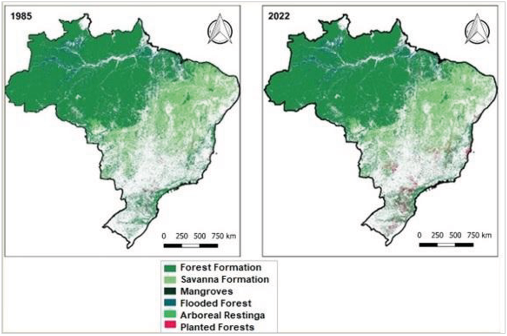
Figure 2 illustrates the land use for Natural Forest and Planted Forest subclasses in Brazil for the years 1985 and 2022. Forest Formation is primarily concentrated in the northern region of the country, with Flooded Forests being exclusive to this area. Savanna Formation is predominantly found in the Central-West and Northeast regions. Mangroves and Arboreal Restinga are mainly located along the Brazilian coast, with Mangroves being more common in the northern region and Arboreal Restinga in the eastern region. The areas represent Planted Forests for commercial purposes, with a notable concentration in the Central-South region and a clear expansion in land use between the two years analyzed. The white areas indicate land used for purposes not covered in this study.
On average, the areas occupied by Natural Forests in the Cerrado, Caatinga, Amazon, and Atlantic Forest biomes were smaller in 2022 compared to 1985, indicating significant differences between the years analyzed. In contrast, no statistically significant changes were observed in the Pantanal and Pampa biomes during this period. As for Planted Forests, the average area in the Cerrado, Amazon, Atlantic Forest, Pampa, and Caatinga biomes was larger in 2022 than in 1985. However, no statistically significant differences were observed for Planted Forests in the Pantanal biome (Table 4).
It is important to note that, despite the reduction of natural vegetation in some Brazilian biomes, restoration and conservation efforts can significantly contribute to carbon storage, helping to address climate challenges linked to greenhouse gas emissions (Barros et al., 2023). Consequently, areas with native vegetation can act as carbon sinks (Teodoro et al., 2024). However, changes in land use and land cover are considered the primary factors influencing carbon sequestration, with the agricultural sector and traditional management practices playing key roles (Chang et al., 2022; Crippra et al., 2021). In general, these changes are driven by both economic and ecological factors (Liang et al., 2021; Wang et al., 2022). Therefore, conserving natural vegetation is a crucial strategy for mitigating greenhouse gas emissions and, consequently, combating climate change (Zhao et al., 2019; Babbar et al., 2021).
In terms of timber commercialization in Brazil, Planted Forests-composed of species exotic to natural biomes-are observed to produce near-zero net carbon dioxide emissions at the end of their life cycle. This is due to the significant amount of carbon sequestered during the plant growth phase (John, 2008; Luyssaert, 2008). In contrast, native timber sourced from the Amazon, for instance, may reduce soil carbon stocks and increase atmospheric carbon concentrations, depending on the exploitation methods used (Numazawa et al., 2017; Campos et al., 2021). Therefore, the cultivation of Planted Forests for commercial purposes presents a more attractive option.
In recent decades, following the predominance of intensive production systems in Brazil, there has been increased investment in integrated production systems, such as Crop-Livestock-Forest Integration (Carvalho et al., 2014). This method offers several benefits, including improved soil quality, reduced risks through better pest control, enhanced animal welfare due to the thermal regulation provided by planted forests, and a reduction in greenhouse gas emissions. These systems can be implemented on farms of various sizes, promoting more efficient use of land and labor (SENAR, 2023). Integrated systems are designed to support sustainable food production, providing biological, physical, and chemical benefits to the soil. In addition to addressing ecological concerns, these systems increase farmers' income by allowing the simultaneous cultivation of complementary crops, which reduces production costs and diversifies investments (Júnior et al., 2021).
However, the implementation of integrated systems still requires improvements, as rural producers face several challenges in adopting this production model. These challenges are primarily related to the lack of financing needed to implement all the management techniques required to optimize the system's functionality. Additionally, a significant obstacle for landowners is the limited research in this field, which hinders the expansion of these systems to more regions across the country (Campoli; Stivali, 2023).
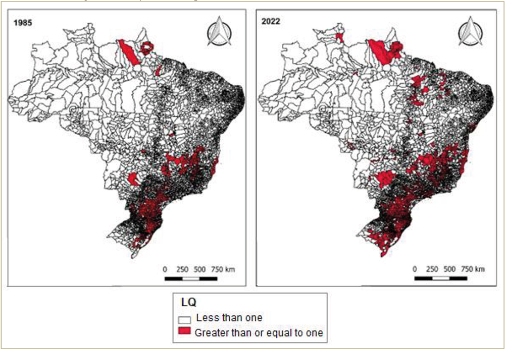
Finally, a Location Quotient (LQ) analysis was conducted (Figure 3) to highlight the concentration of a specific activity within a region. The concentration of Planted Forests across Brazil was examined, with municipalities marked in red indicating an LQ result of 1 or greater. In 1985, municipalities in the South and Southeast regions formed a corridor with an LQ > 1 for Planted Forests, signifying a higher concentration of this productive activity in these areas compared to the national level. A smaller number of municipalities with LQ > 1 were also identified in other regions, such as the North and Central-West, demonstrating the presence of silviculture in various parts of the country during that year. By 2022, the number of municipalities with LQ > 1 had increased across the nation, with many bordering those that had already shown this result in 1985. Moreover, municipalities with LQ > 1 were now present in all regions of Brazil, indicating the expansion of this productive system nationwide.

The results from the LQ analysis were expected, as the South and Southeast regions account for more than 80% of the firewood production from silviculture in Brazil. Over the years, states in the South, Southeast, and Central-West regions have seen an increase in wood production from silviculture, largely due to stricter regulations on the extraction of wood from Natural Forests and efforts to curb deforestation (Simioni et al., 2017).
Deforestation has been a prominent issue in Brazil for decades, with historical records showing the creation of Legislative Decree No. 4421 in 1921, which aimed to protect the nation's forests (Meira, 2015). Despite these early efforts, deforestation continues, leading to the designation of two biodiversity hotspots in Brazil: the Atlantic Forest and Cerrado biomes (Peixoto et al., 2016). Additionally, the debate around combating deforestation in the Amazon remains ongoing (Dias et al., 2024). In this context, silviculture is seen as a strategy to balance industrial and environmental interests, as it can help meet timber demand without the need for extraction from Natural Forests (Meira, 2015).
In addition, planted forests are estimated to be responsible for the stock of approximately 1.7 billion tons of CO2, and contribute to the provision of raw materials for various applications in which wood can be used as a raw material (FAO, 2020; IBÁ, 2020). In addition, productive management such as the Integrated Crop-Livestock-Forest System can make use of modern forestry, which is associated with the planting of forests (Barros, 2021). In this productive system, the plant components (pasture, legume crops, and trees) carry out the process of photosynthesis and can capture carbon dioxide (CO2) and fix carbon in the leaves, roots, and stem. This entire process can offset the methane emission from cattle inserted in the production process, reducing or neutralizing the greenhouse gases emitted (Assad et al., 2015).
FINAL CONSIDERATIONS
The objective of this study was to analyze the spatial-temporal changes in Natural and Planted Forests in Brazil. The findings indicate a general decrease in the area occupied by Natural Forests, accompanied by an increase in Planted Forests. The extraction of Natural Forests can lead to environmental issues associated with ecosystem disruption. However, with increasing awareness of the need to preserve Natural Forests, it is believed that these resources are gaining greater market value due to their crucial role in climate regulation.
However, despite the perceived increase in the value of Natural Forests, this is not yet reflected in their preservation in Brazil, as their area continues to decline in each period of analysis. Conversely, the area of Planted Forests has expanded, providing an alternative source of timber to meet human needs. As such, Planted Forests can be viewed as a substitute for wood sourced from Natural Forests. This raw material, utilized by industry, generates income for rural producers who have adopted this form of production.
It is believed that the expansion of Planted Forests in Brazil over the years has been driven by the growing demand for this raw material in both domestic and international markets, as Brazil is a significant exporter of wood products. Additionally, as noted earlier, Planted Forests consist of species exotic to Brazil's native flora and have replaced native vegetation, particularly in the Atlantic Forest and Cerrado biomes, since the earliest period of analysis.
It is also necessary to consider that planted forests may not perform the same environmental functions as natural forests, due to their characteristics that are exotic to Brazilian biomes, and may influence the ecological balance. Furthermore, these advances in forest planting may be associated with public actions aimed at developing the agro-industrialization of cellulose in different regions, as is the case of the public incentives proposed in the Central-West region. And also, with production systems that aim at carbon fixation in favor of reducing greenhouse gases, implying the aggregation of value associated with products that will be marketed through green marketing. Both situations are linked to the increase in economic development arising from rural activities, which are often non-traditional activities, which can help keep people in the countryside, due to the financial results.
Future studies could explore which types of land use or production were displaced to accommodate the expansion of tree planting in Brazil, as well as the cost of using natural resources related to these activities.
DATA AVAILABILITY
The data that support the findings of this study can be made available, upon reasonable request, from the corresponding author [Daiany Stéfani Martins Vieira Leite].
REFERENCES
-
ABREU, R. C. L.; LEMOS, F. K. Brazilian agriculture and the global environmental agenda. In: SØNDERGAARD, N., SÁ, C. D., BARROS-PLATIAU, A. F. (Eds.), Sustainability Challenges of Brazilian Agriculture, Environment & Policy, v. 64. Springer, New York, p. 85-105, 2023. https://doi.org/10.1007/978-3-031-29853-0_5
» https://doi.org/10.1007/978-3-031-29853-0_5 -
AFUYE, G. A.; KALUMBA, A. M.; ISHOLA, K. A.; ORIMOLOYE, I. R. Long-term dynamics and response to climate change of different vegetation types using GIMMS NDVI3g data over amathole district in South Africa. Atmosphere, v. 13, n. 4, p. 620. 2022. https://doi.org/10.3390/atmos13040620
» https://doi.org/10.3390/atmos13040620 -
ASSAD, E. D.; CORDEIRO, L. A. M.; MARCHÃO, R. L.; ALMEIDA, R. G.; GUIMARÃES JÚNIOR, R.; BERNDT, A.; SALTON, J. C.; EVANGELISTA, B. A. Potencial de mitigação da emissão de gases de efeito estufa por meio da adoção da estratégia de integração lavoura-pecuária-floresta. Embrapa Gado de Corte-Capítulo em livro científico (ALICE). 2015. Available: https://www.alice.cnptia.embrapa.br/bitstream/doc/1023603/1/9000033ebookpdf.pdf Accessed on: may 2025.
» https://www.alice.cnptia.embrapa.br/bitstream/doc/1023603/1/9000033ebookpdf.pdf -
BABBAR, D.; AREENDRAN, G.; SAHANA, M.; SARMA, K.; RAJ, K., SIVADAS, A. Assessment and prediction of carbon sequestration using Markov chain and InVEST model in Sariska Tiger Reserve, India. Journal of Cleaner Production, v. 278. 2021. https://doi.org/10.1016/j.jclepro.2020.123333
» https://doi.org/10.1016/j.jclepro.2020.123333 -
BANCO CENTRAL DO BRASIL. Atividade Econômica. 2023. Available: https://www.bcb.gov.br/content/publicacoes/boletimregional/202312/br202312c1p.pdf Accessed on: may 2025.
» https://www.bcb.gov.br/content/publicacoes/boletimregional/202312/br202312c1p.pdf -
BARBOZA, A.C.G.; TAGLIACOLLO, V.; JACOBUCCI, G.B. Influence of seasonal hydrological regimes on benthic macroinvertebrates in two the Brazilian biodiversity hotspots. Limnologica, v. 106. 2024. https://doi.org/10.1016/j.limno.2024.126170
» https://doi.org/10.1016/j.limno.2024.126170 -
BARROS, F.D.V.; LEWIS, K., ROBERTSON, A.D.; PENNINGTON, R.T.; HILL, T.C.; MATTHEWS, C.; LIRA-MARTINS, D.; MAZZOCHINI, G.G.; OLIVEIRA, R.S.; ROWLAND, L. Cost-effective restoration for carbon sequestration across Brazil’s biomes. Science of The Total Environment, v. 876. 2023. https://doi.org/10.1016/j.scitotenv.2023.162600
» https://doi.org/10.1016/j.scitotenv.2023.162600 -
BARROS, T. D. Silvicultura. Embrapa. 2021. Available: https://www.embrapa.br/agencia-de-informacao-tecnologica/tematicas/agroenergia/florestal/silvicultura Accessed on: may 2025.
» https://www.embrapa.br/agencia-de-informacao-tecnologica/tematicas/agroenergia/florestal/silvicultura -
BROADBENT, E. N.; ZAMBRANO, A. M. A.; DIRZO, R., DURHAM, W. H.; DRISCOLL, L.; GALLAGHER, P.; RANDOLPH, S. G. The effect of land use change and ecotourism on biodiversity: a case study of Manuel Antonio, Costa Rica, from 1985 to 2008. Landscape Ecology, v. 27, p. 731-744. 2021. https://doi.org/10.1007/s10980-012-9722-7
» https://doi.org/10.1007/s10980-012-9722-7 -
CAMPOS, E. F. D.; PUNHAGUI, K. R. G.; JOHN, V.M. CO2 footprint of Amazon lumber: a meta-analysis. Resources Conservation Recycling. v. 167. 2021. https://doi.org/10.1016/j.resconrec.2020.105380
» https://doi.org/10.1016/j.resconrec.2020.105380 -
CARVALHO, P. C. F; MORAES, A; PONTES, L. S; ANGHINONI, I; SULE, R. M; BATELLO, C. (Special). Definições e terminologias para Sistema Integrado de Produção Agropecuária. Revista Ciência Agronômica, v. 45, n. 5 (Especial), p. 1040-1046. 2014. https://doi.org/10.1590/S1806-66902014000500020
» https://doi.org/10.1590/S1806-66902014000500020 -
CHANG, X.; XING, Y.; WANG, J.; YANG, H.; GONG, W. Effects of land use and cover change (LUCC) on terrestrial carbon stocks in China between 2000 and 2018. Resources Conservation Recycling. 182, 106333. 2022. https://doi.org/10.1016/j.resconrec.2022.106333
» https://doi.org/j.resconrec.2022.106333 -
CHENG, K.; YANG, H.; GUAN, H.; REN, Y.; CHEN, Y.; CHEN, M.; YANG, Z.; LIN, D.; LIU, W.; XU, J.; XU, G.; MA, K.; GUO, Q. Unveiling China’s natural and planted forest spatial-temporal dynamics from 1990 to 2020. ISPRS Journal of Photogrammetry and Remote Sensing, v. 209, p. 37-50. 2024. https://doi.org/10.1016/j.isprsjprs.2024.01.024
» https://doi.org/10.1016/j.isprsjprs.2024.01.024 -
COLLIER, K.J.; CLAPCOTT, J.E.; HAMER, M.P.; YOUNG, R.G. Extent estimates and land cover relationships for functional indicators in non-wadeable rivers. Ecological Indicators. v. 34, p. 53-59. 2013. https://doi.org/10.1016/j.ecolind.2013.04.010
» https://doi.org/10.1016/j.ecolind.2013.04.010 -
COLOMBO, A.F.; JOLY, C.A. Brazilian Atlantic Forest lato sensu: The most ancient Brazilian forest, and a biodiversity hotspot, is highly threatened by climate change. Brazilian Journal of Biology. v. 70, p. 697-708. 2010. https://doi.org/10.1590/S1519-69842010000400002
» https://doi.org/10.1590/S1519-69842010000400002 -
CRIPPA, M.; SOLAZZO, E.; GUIZZARDI, D.; MONFORTI-FERRARIO, F.; TUBIELLO, F.N.; LEIP, A.J.N.F. Food systems are responsible for a third of global anthropogenic GHG emissions. Nature Food v. 2, n. 3, p. 198-209, 2021. https://doi.org/10.1038/s43016-021-00225-9
» https://doi.org/10.1038/s43016-021-00225-9 -
CAMPOLI, J. S; STIVALI, M. Custo social do desmatamento nos biomas brasileiro. IPEA. 2023. https://doi.org/10.38116/td2842
» https://doi.org/10.38116/td2842 -
DA CUNHA, E.R.; SANTOS, C.A.G.; DA SILVA, R.M.; PANACHUKI, E, DE OLIVEIRA, P.T.S.; DE SOUZA OLIVEIRA, N.; DOS SANTOS FALCÃO, K. Assessment of current and future land use/cover changes in soil erosion in the Rio da Prata basin (Brazil) Science of The Total Environment, v. 818. 2022. https://doi.org/10.1016/j.scitotenv.2021.151811
» https://doi.org/10.1016/j.scitotenv.2021.151811 -
DIAS, F.; SUHADOINIK, N.; CAMARGO, H.; DA SILVA, S. Predicting the pulse of the Amazon: Machine learning insights into deforestation dynamics. Journal of Environmental Management, 362, 2024. https://doi.org/10.1016/j.jenvman.2024.121359
» https://doi.org/10.1016/j.jenvman.2024.121359 -
EMBRAPA. Crescimento das exportações brasileiras e atendimento a novos mercados. 2021. Available: https://www.embrapa.br/visao-de-futuro/intensificacao-tecnologica-e-concentracao-da-producao/sinal-e-tendencia/crescimento-das-exportacoes-brasileiras-e-atendimento-a-novos-mercados Accessed on: may 2025.
» https://www.embrapa.br/visao-de-futuro/intensificacao-tecnologica-e-concentracao-da-producao/sinal-e-tendencia/crescimento-das-exportacoes-brasileiras-e-atendimento-a-novos-mercados -
EMBRAPA. Silvicultura. 2021. Available: https://www.embrapa.br/agencia-de-informacao-tecnologica/tematicas/agroenergia/florestal/silvicultura#:~:text=A%20palavra%20silvicultura%20prov%C3%A9m%20do,atender%20%C3%A0s%20exig%C3%AAncias%20do%20mercado Accessed on: apr. 2024.
» https://www.embrapa.br/agencia-de-informacao-tecnologica/tematicas/agroenergia/florestal/silvicultura#:~:text=A%20palavra%20silvicultura%20prov%C3%A9m%20do,atender%20%C3%A0s%20exig%C3%AAncias%20do%20mercado -
FAO - Food and Agriculture Organization. Global Forest Resources Assessment. 2020. Available: https://www.fao.org/documents/card/en/c/ca9825en Accessed on: may 2025.
» https://www.fao.org/documents/card/en/c/ca9825en -
FEBRATEX. Indústria têxtil: entenda as oportunidades do setor. 2020 Available: https://fcem.com.br/noticias/industria-textil-entenda-as-oportunidades-do-setor/ Accessed on: jun. 2024.
» https://fcem.com.br/noticias/industria-textil-entenda-as-oportunidades-do-setor/ -
FRANÇOSO, R.D.; BRANDÃO, R.; NOGUEIRA, C.C.; SALMONA, Y.B.; MACHADO, R.B.; COLLI, G.R. Habitat loss and the effectiveness of protected areas in the Cerrado Biodiversity Hotspot. Natureza e Conservação, v. 13, p. 35-40, 2015. http://doi.org/10.1016/j. ncon.2015.04.001
» https://doi.org/10.1016/j. ncon.2015.04.001 -
IBÁ - Indústria Brasileira de Árvores. Relatório de 2020. 2020. Available: https://iba.org/datafiles/publicacoes/relatorios/relatorio-iba-2020.pdf Accessed on: may 2025.
» https://iba.org/datafiles/publicacoes/relatorios/relatorio-iba-2020.pdf -
IBGE. Valor de produção da silvicultura e da extração vegetal cresce 27,1% e chega ao recorde de R$ 30,1 bilhões. 2022. Available: https://agenciadenoticias.ibge.gov.br/agencia-noticias/2012-agencia-de-noticias/noticias/35056-valor-de-producao-da-silvicultura-e-da-extracao-vegetal-cresce-27-1-e-chega-ao-recorde-de-r-30-1-bilhoes Accessed on: jun. 2024.
» https://agenciadenoticias.ibge.gov.br/agencia-noticias/2012-agencia-de-noticias/noticias/35056-valor-de-producao-da-silvicultura-e-da-extracao-vegetal-cresce-27-1-e-chega-ao-recorde-de-r-30-1-bilhoes -
IBGE. Cidades e Estados do Brasil. 2024. Available: https://cidades.ibge.gov.br/ Accessed on: jun. 2024.
» https://cidades.ibge.gov.br/ -
IBGE. (2020). Monitoramento da cobertura e uso da terra do brasil 2016 - 2018. Available: https://www.ibge.gov.br/apps/monitoramento_cobertura_uso_terra/v1/pdf/Relatorio_MONITORAMENTO_16_18.pdf Accessed on: apr. 2024.
» https://www.ibge.gov.br/apps/monitoramento_cobertura_uso_terra/v1/pdf/Relatorio_MONITORAMENTO_16_18.pdf - IBÁ - Indústria Brasileira de Árvores. Relatório IBÁ 2019 - Ano Base 2018. São Paulo: IBÁ, 80p. 2019.
-
JOHN, M. Carbon-negative biofuels. The Energy Policy. v. 36, p. 940-945. 2008. https://doi.org/10.1016/j.enpol.2007.11.029
» https://doi.org/10.1016/j.enpol.2007.11.029 -
JUNIOR, J. C. S; ROCHA, L. L; OLIVEIRA, O. A. M; PEIXOTO, R. M; SILVA, R. M; ROCHA, F. R. T; BUENO, C. P; GIONGO, P. R; KLEIN, J. L. Sistemas Integrados de Produção Agropecuária: análise descritiva das ações desenvolvidas por instituições governamentais no Estado de Goiás. Research, Society and Development, v. 10, n. 11, e228101119414. 2021. https://doi.org/10.33448/rsd-v10i11.19414
» https://doi.org/10.33448/rsd-v10i11.19414 -
KARINA, K.; RICHARD, F.; MARK, R.; MARTIN, H. Global land use changes are four times greater than previously estimated. Nature Communications. 12, 2501. 2021. https://doi.org/10.1038/s41467-021-22702-2
» https://doi.org/10.1038/s41467-021-22702-2 -
LIANG, Y.; HASHIMOTO, S.; LIU, L. Integrated assessment of land-use/land-cover dynamics on carbon storage services in the Loess Plateau of China from 1995 to 2050. Ecological Indicators, v. 120, 106939. 2021. https://doi.org/10.1016/j.ecolind.2020.106939
» https://doi.org/10.1016/j.ecolind.2020.106939 -
LUYSSAERT, S.; SCHULZE, E.; BORNER, A.; KNOHL, A.; HESSENMOLLER, D.; LAW, B.; CIAIS, P.; GRACE, J. Old-growth forests as global carbon sinks. Nature, v. 455, p. 213-215. 2008. https://doi.org/10.1038/nature07276
» https://doi.org/10.1038/nature07276 -
MMA - Ministério Do Meio Ambiente. Florestas. 2024. Available: https://antigo.mma.gov.br/florestas.html#:~:text=As%20florestas%20brasileiras%20desempenham%20importantes,do%20Meio%20Ambiente%20(MMA) Accessed on: jun. 2024.
» https://antigo.mma.gov.br/florestas.html#:~:text=As%20florestas%20brasileiras%20desempenham%20importantes,do%20Meio%20Ambiente%20(MMA) -
MPANYARO, Z.; KALUMBA, A.M.; ZHOU, L.; AFUYE, G.A. Mapping and Assessing Riparian Vegetation Response to Drought along the Buffalo River Catchment in the Eastern Cape Province. South Africa. Climate, v. 12, n. 1, p. 7. 2024. https://doi.org/10.3390/cli12010007
» https://doi.org/10.3390/cli12010007 -
MAPBIOMAS. Mapeamento anual de cobertura e uso da terra no Brasil entre 1985 a 2022. 2024a. Available: https://brasil.mapbiomas.org/wp-content/uploads/sites/4/2023/08/FACT_MapBiomas_Mapeamento-Anual-Cobertura_Colecao8_31.pdf Accessed on: apr. 2024.
» https://brasil.mapbiomas.org/wp-content/uploads/sites/4/2023/08/FACT_MapBiomas_Mapeamento-Anual-Cobertura_Colecao8_31.pdf -
MAPBIOMAS. Descrição da Legenda Coleção 8. 2024b. Available: https://brasil.mapbiomas.org/wp-content/uploads/sites/4/2023/08/Legenda-Colecao-8-Descricao-Detalhada-PDF-PT-2.pdf Accessed on: jul. 2024.
» https://brasil.mapbiomas.org/wp-content/uploads/sites/4/2023/08/Legenda-Colecao-8-Descricao-Detalhada-PDF-PT-2.pdf -
MAPBIOMAS. Em 38 anos o Brasil perdeu 15% de suas florestas naturais. 2023. Available: https://brasil.mapbiomas.org/2023/10/20/em-38-anos-o-brasil-perdeu-15-de-suas-florestas-naturais/#:~:text=Os%20estados%20com%20maior%20propor%C3%A7%C3%A3o,(47%20milh%C3%B5es%20de%20hectares) Accessed on: jul. 2023.
» https://brasil.mapbiomas.org/2023/10/20/em-38-anos-o-brasil-perdeu-15-de-suas-florestas-naturais/#:~:text=Os%20estados%20com%20maior%20propor%C3%A7%C3%A3o,(47%20milh%C3%B5es%20de%20hectares) -
MEIRA, R. B; CARELLI, M. N. Notas Sobre Florestas no Brasil da Primeira República: Silvicultura, Preservação da Natureza e Agricultura. Fronteiras: Journal of Social, Technological and Environmental Science, v. 4, n. 1, jan. - jul, p. 301-312. 2015. https://doi.org/10.21664/2238-8869.2015v4i1.p301-312
» https://doi.org/10.21664/2238-8869.2015v4i1.p301-312 -
MYERS, N.; MITTERMELER, R.A.; MITTERMELER, C.G.G.; DA FONSECA, G.A.B.B.; KENT, J. Biodiversity hotspots for conservation priorities. Nature, v. 403, p. 853-858. 2000. https://doi. org/10.1038/35002501
» https://doi.org/10.1038/35002501 -
NATH, A.; KOLEY, B.; CHOUDHURY, T.; SARASWATI, S.; RAY, B.C.; UM, J.S.; SHARMA, A. Assessing Coastal Land Use and Land-cover Change Dynamics Using Geospatial Techniques. Sustainability, v. 15, n. 9, p. 7398. 2023. https://doi.org/10.3390/su15097398
» https://doi.org/10.3390/su15097398 -
NUMAZAWA, C.T.D.; NUMAZAWA, S.; PACCA, S.; JOHN, V.M. Logging residues and CO2 of Brazilian Amazon timber: two case studies of forest harvesting, Resources Conservation and Recycling. v. 122, p. 280-285. 2017. https://doi.org/10.1016/j.resconrec.2017.02.016
» https://doi.org/10.1016/j.resconrec.2017.02.016 - OLIVEIRA, Y. M. M. de; GARRASTAZU, M. C.; ROSOT, M. A. D.; LUZ, N. B.; SCHAITZA, E. G. Plantações florestais comerciais no contexto da paisagem. In: Oliveira, Y. M. M. de; Oliveira, E. B. de (Ed.). Plantações florestais: geração de benefícios com baixo impacto ambiental. Brasília, DF: Embrapa. 2017b.
-
OLIVEIRA, Y. M. M; OLIVEIRA, E. B. As florestas plantadas e sua importância no contexto econômico e socioambiental do Brasil. Anais. 4° Encontro Brasileiro de Silvicultura 9 e 10 de abril de 2018-Ribeirão Preto, SP, Brasil. 2018. Available: https://www.alice.cnptia.embrapa.br/alice/bitstream/doc/1092385/1/2018AACYedaEBSAsFlorestas.pdf Accessed on: jul. 2024.
» https://www.alice.cnptia.embrapa.br/alice/bitstream/doc/1092385/1/2018AACYedaEBSAsFlorestas.pdf - PEIXOTO, A.L. LUZ, J.R.P.; DE BRITO, M.A. Conhecendo a Biodiversidade. Brasília: MCTIC, CNPq, PPBio. 2016.
-
PENA-VERGANA, G.; CASTRO, L.R.; GASPARETTO, C.A.; BIZZO, W.A. Energy from planted forest and its residues characterization in Brazil. Energy, 239. 2022. https://doi.org/10.1016/j.energy.2021.122243
» https://doi.org/10.1016/j.energy.2021.122243 -
RIBEIRO, M.C.; MARTENSEN, A.C.; METZGER, J.P.; TABARELLI, M.; SCARANO, F.; FORTIN, M.J. The Brazilian Atlantic Forest: a shrinking biodiversity hotspot. Biodiversity Hotspots. p. 405-434. 2011. https://doi.org/10.1007/978-3-642-20992-5_21
» https://doi.org/10.1007/978-3-642-20992-5_21 -
SANGUINET, E.R.; Azzoni, C.R. Carbon emissions drivers in Brazilian regional production chains: Value-added and consumption-based approaches. Regional Science Policy & Practice, v. 16 n. 8. 2024. https://doi.org/10.1016/j.rspp.2024.100015
» https://doi.org/10.1016/j.rspp.2024.100015 -
SCHIRPKE, U.; TASSER, E.; BORSKY, S.; BRAUN, M.; EITZINGER, J.; GAUBE, V.; GETZNER, M., GLATZEL, S.; GSCHWANTNER, T.; KIRCHNER, M. Past and future impacts of land-use changes on ecosystem services in Austria. Journal of Environmental Management. 345, 118728. 2023. https://doi.org/10.1016/j.jenvman.2023.118728
» https://doi.org/10.1016/j.jenvman.2023.118728 -
SIMIONI, F. J; MOREIRA, J. M. M. A. P; FACHINELLO, A. L; BUSCHINELLI, C. C. A; MATSUURA, M. I. S. F. Evolução e concentração da produção de lenha e carvão vegetal da silvicultura no Brasil. Ciência Florestal, Santa Maria, v. 27, n. 2, p. 731-742, apr. - jun. 2017. https://doi.org/10.5902/1980509827758
» https://doi.org/10.5902/1980509827758 -
SNIF - Sistema Nacional De Informações Florestais. Florestas plantadas. 2019. Available: https://snif.florestal.gov.br/pt-br/florestas-plantadas Accessed on: jun. 2024.
» https://snif.florestal.gov.br/pt-br/florestas-plantadas -
SENAR. Sistema ILPF: entenda cada um dos seus componentes. 2023. Available: https://ead.senargo.org.br/blog/sistema-ilpf-entenda-cada-um-dos-seus-componentes#:~:text=Um%20sistema%20de%20ILPF%20favorece,quanto%20para%20a%20propriedade%20rural.&text=Se%20voc%C3%AA%20quer%20mergulhar%20nos,Introdu%C3%A7%C3%A3o%20aos%20sistemas%20de%20ILPF Accessed on: jun. 2024.
» https://ead.senargo.org.br/blog/sistema-ilpf-entenda-cada-um-dos-seus-componentes#:~:text=Um%20sistema%20de%20ILPF%20favorece,quanto%20para%20a%20propriedade%20rural.&text=Se%20voc%C3%AA%20quer%20mergulhar%20nos,Introdu%C3%A7%C3%A3o%20aos%20sistemas%20de%20ILPF -
STATE OF RONDÔNIA. Rondônia é o terceiro maior produtor de grãos da Região Norte. 2021. Available: https://rondonia.ro.gov.br/rondonia-e-o-terceiro-maior-produtor-de-graos-da-regiao-norte/ Accessed on: jun. 2024.
» https://rondonia.ro.gov.br/rondonia-e-o-terceiro-maior-produtor-de-graos-da-regiao-norte/ -
TEIXEIRA, G.; RODRIGUES, G.S.S.C. Trajetória Geográfica da Silvicultura em Minas Gerais. Mercator, 20. 2021. https://doi.org/10.4215/rm2021.e20004
» https://doi.org/10.4215/rm2021.e20004 -
TEODORO, P.E.; ROSSI, F.S.; TEODORO, L.P.R.; SANTANA, D.C.; RATKE, R.F.; DE OLIVEIRA, I.C.; SILVA, J.L.D.; OLIVEIRA, J.L.G.; SILVA, N.P.; BAIO, F.H.R.; TORRES, F.E.; DA SILVA JUNIOR, C. A. Soil CO2 emissions under different land-use managements in Mato Grosso do Sul, Brazil. Journal of Cleaner Production. 434, 2024. https://doi.org/10.1016/j. jclepro.139983
» https://doi.org/10.1016/j. jclepro.139983 -
UN. Como alimentar 10 bilhões de pessoas até 2050. 2020. Available: https://www.unep.org/pt-br/noticias-e-reportagens/reportagem/como-alimentar-10-bilhoes-de-pessoas-ate-2050 Accessed on: apr. 2024.
» https://www.unep.org/pt-br/noticias-e-reportagens/reportagem/como-alimentar-10-bilhoes-de-pessoas-ate-2050 -
WANG, X.; ZHENG, H.; AHN, K.; ZHANG, X.W.; DESHPANDE, S.R.; SOTO, C.; PENG, H. Trade for food security: the stability of global agricultural trade networks. IFAC-PapersOnLine, v. 56 n. 3, p. 271-276. 2023. https://doi.org/10.1016/j.ifacol.2023.12.036
» https://doi.org/10.1016/j.ifacol.2023.12.036 -
WANG, Z.; LI, X.; MAO, Y.; LI, L.; WANG, X.; LIN, Q. Dynamic simulation of land use change and assessment of carbon storage based on climate change scenarios at the city level: a case study of Bortala, China. Ecological Indicators. 134, 108499. 2022. https://doi.org/10.1016/j.ecolind.2021.108499
» https://doi.org/10.1016/j.ecolind.2021.108499 -
ZHAO, M.; HE, Z., DU, J.; CHEN, L.; LIN, P.; FANG, S. Assessing the effects of ecological engineering on carbon storage by linking the CA-Markov and InVEST models. Ecological Indicators. v. 98, p. 29-38. 2019. https://doi.org/10.1016/j.ecolind.2018.10.052
» https://doi.org/10.1016/j.ecolind.2018.10.052
-
ASSOCIATE EDITOR
Silvio Carlos Rodrigues - 0000-0002-5376-1773

 Source: The authors (2024).