
 Hydraulic Dynamics of the Riparian Soil in the Chapadão do Diamante - Serra da Canastra, Minas Gerais
Abstract
Serra da Canastra National Park, located in the Cerrado Biome in the State of Minas Gerais, Brazil, consolidates a conservation unit that includes the sources of several important Brazilian hydrographic basins. Given the significance of local and national water supply and regulation, this study aimed to analyze and understand the physical-hydraulic characteristics of the soil in the riparian zone within the park. Field data were collected using a rainfall simulator and a concentric ring infiltrometer. The results demonstrated an elevated infiltration capacity in the study área. Only 23.74% of the 57.4mm of artificially precipitated high-intensity rainfall was runoff. Basic infiltration velocity (BIV) values were considered very high (50.74 mm/h). Overall, these values were associated with the characteristics of the landscape, highlighting the importance of vegetation in the soil cover and the physical attributes of the soil. These factors influenced the modulation of the soil's capacity to retain, infiltrate, and store large volumes of water. In this regard, the importance of these riparian zones for the environment was emphasized as they play a crucial role in protecting watercourses. They act as barriers against erosive flow from upstream areas, incorporating water into the soil profile to store and release over time. These areas thus become important sites for water regulation.
Keywords:
Water infiltration; Surface runoff; Water in Cerrado
Resumo
O parque nacional da Serra da Canastra-MG consolida-se como uma unidade de conservação inserida no Bioma de Cerrado que abriga em seu interior nascentes de importantes bacias hidrográficas brasileiras. Visto sua importância para dinâmica hídrica local e nacional, este trabalho teve por objetivo de analisar e compreender as características físico-hídricas do solo de uma zona ripária presente em seu interior. Utilizou-se para prospecção de dados de campo um simulador de chuvas e um infiltrômetro de anéis concêntricos. Os resultados demostraram para área em estudo alta capacidade de infiltração, sendo escoados superficialmente 23,74% dos volumes precipitados artificialmente (intensidade 57,4mm/h), expondo valores de velocidade de infiltração básica (VIB) considerados como muito altos (50,74 mm/h). No geral, os valores estão associados a dinâmica dos elementos paisagísticos, destacando a relevância da vegetação em sua cobertura vegetal e dos atributos físicos do solo, os quais repercutiram na modulação de sua capacidade de reter, infiltrar e armazenar grandes volumes de água. Neste sentido, destaca-se a importância destas áreas para os ambientes, as quais são responsáveis pela proteção dos cursos d’água, consolidando-se como barreiras frente a fluxos erosivos advindos de áreas vertente acima, incorporando a água no perfil do solo de modo a armazená-la e disponibilizá-la ao longo do tempo, tornando-se locais de regulação hídrica.
Palavras-chave:
Infiltração de água; Escoamento superficial; Água no Cerrado
INTRODUCTION
Water management is essential for the development of societies. It is necessary to produce precise information about water infiltration rates and displacement forms in different soil types to adopt more assertive practices for the use and conservation of environments (Taylor et al., 2012).
Water infiltration is a dynamic process of great importance for the hydrological cycle and water balance (Rahmati et al., 2018; Confessor, 2019). The movement of water penetrates the surface, influencing various soil processes and functions (Santos et al., 2015).
This includes water and nutrient availability for plants, microbial activity, erosion rates, physical and chemical weathering, as well as thermal and gas exchanges between soil and atmosphere (Campbell, 1985; Klein; Klein, 2015; Carvalho et al., 2021; Confessor et al., 2022).
For understanding this dynamic, field data collection is essential to reveal behavioral conditions of the flow (Morbidelli et al., 2017). Also, studying the natural areas of the research sites not only aids in understanding system functions but also is necessary for model parameterization, serving as a comparative data source for areas at different stages of human alteration.
In this context, the Parque Nacional da Serra da Canastra - Serra da Canastra National Park (Parnacanastra) stands out as a unit of integral protection, exhibiting elevated topographic characteristics compared to surrounding areas with different cerrado phytophysiognomies and creates large hydrographic basin springs (São Francisco and Paraná). These springs are considered strategic for the national and international territory (Silva, 2020; Rodrigues et al., 2023; Confessor et al., 2024a).
Given the area’s importance for local and national hydrological dynamics, this study aimed to enhance understanding of the physical-hydraulic characteristics of soil in a riparian zone within the Serra da Canastra National Park - MG, producing a primary field data survey involving the use of flood and sprinkler infiltrometers, correlating the collected data with the landscape elements in the area.
MATERIALS AND METHODS
The area of Chapadão do Diamante, belonging to the Parnacanastra, has been categorized into different classes and subdivided based on material characteristics, topography, and aerogamma spectrometric data (Nazar; Rodrigues, 2019a, 2019b).
Among these classes, the land cover of Organic Materials associated with wet areas covers an area of 8.97% of the entire plateau, occurring mainly in valley bottoms and is primarily related to heavily dissected relief patterns, where entrenched valleys and sometimes streams running over rock are observed (Nazar, 2018).
The occurrence of organic materials near areas of permanent or temporary water saturation characterizes them as riparian zones (Attanasio et al., 2013), They play an important role from both hydrological and ecological perspectives in the areas where they assist in maintaining environmental health as well as the resilience of the watershed (Pert et al., 2010).
In order to understand the water dynamics of these areas, this study was conducted in a riparian zone of a slope of the Chapadão do Diamante, precisely at coordinates 20°13'56.48"S and 46°36'29.83"W. Field experiments were conducted using two types of infiltrometers, namely a Rainfall Simulator and a Semiautomatic Constant Head Infiltrometer with reduced variable load and field tests carried out during the inter-rainfall period of the region to avoid possible interference from natural rainfall volumes.
The Rainfall Simulator was built and adjusted to reproduce high-intensity rain similar to that occurring in the study area (Figure 1). The procedures are explained in Confessor (2023). In summary, the equipment was calibrated based on information collected by the Vargem Bonita Climatological Station (2046013), which provided 46 years of precipitation data.
From the data analysis, an intensity of 57.4 mm/h was established using a regression analysis of erosive rainfall volumes found in the region. This volume was replicated in simulated rainfall at three random locations in the research area, with simulated rains of 60 minutes.
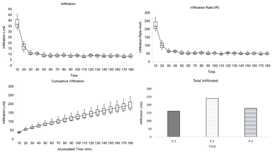
To assess the maximum soil infiltration capacity, a Semiautomatic Constant Head Infiltrometer with reduced variable load was used (Confessor, 2023). This established a water column of 5 centimeters on the surface for 3 hours of experiments (Figure 1). Infiltration values were recorded at 10-minute intervals, totaling 18 samplings, with three tests conducted in the study área. Collection points were determined randomly.

Equipment used in the research. Semiautomatic constant head infiltrometer with reduced variable load (A and B); Rainfall simulator and wind protection (C and D).
The vegetation cover was evaluated using ENVI 4.2 software, employing supervised image classification (Pinese Júnior et al., 2008). For this purpose, images of the plots were captured at a distance of 1 meter from the ground, moments before the rainfall simulations.
Soil classification in the area was carried out using the Brazilian soil classification system (Santos, 2018). In addition to classification, undisturbed surface samples were collected at 4 randomly scattered points in the area to assess total soil density, particle density, and total porosity. Disturbed subsurface samples were collected to determine granulometric characteristics, taken every 10 centimeters up to 50 centimeters depth, and subsequently treated according to established procedures (Teixeira et al., 2017).
After granulometric separation, the samples were classified using the coefficients of non-uniformity (CNU) and curvature (CC). In this context, CNU permits characterizing the soil regarding homogeneity of the particle size distribution, classifying the soil as very uniform (CNU < 5); moderately uniform (CNU 5 to 15); or non-uniform (CNU > 15), with values obtained from the following equation (Souza; Bastos, 2015):
In which:
-
CNU - coefficient of non-uniformity;
-
D10 - 10th percentile;
-
D60 - 60th percentile.
The curvature coefficient, on the other hand, analyzes the shape of the granule size distribution curve and allows identifying the distribution of granule sizes, classifying the soil as well-graded (CC between 1 and 3) or poorly-graded (CC > 3), represented by the following equation (Souza; Bastos, 2015):
In which:
-
CC - Curvature coefficient;
-
D10 - 10th percentile;
-
D30 - 30th percentile;
-
D60 - 60th percentile.
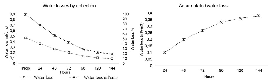
The investigation of soil water loss through evaporation involved the collection of undisturbed samples in 100 cm3 volumetric rings at a depth of 0 to 5 centimeters. The samples were submerged in water for 2 hours, drained, and weighed 1 hour later. Subsequently, they were weighed at 24-hour intervals over six days (Confessor, 2023). Water loss was thus monitored by the variation in weight between the initial sample and those subsequent.
RESULTS AND DISCUSSIONS
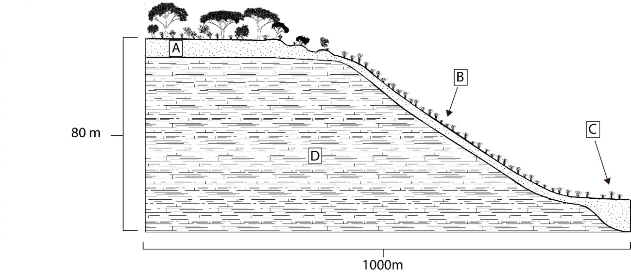
The study slope has a length of 1000 meters, with a gradient between the hilltop and valley bottom of 80 meters (Figure 2). It exhibits different types of vegetation cover, soils, and slopes along its discent. The land cover, Organic Materials, occupies a small area of the study slope located in the valley bottom and forms a thin strip that borders the stream. This lowest part of the terrain has an average slope of 15.5% along its length.
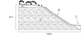
Study slope. Deeper soils in flat areas at the top of the slope (A); shallow soils in the middle third of the slope (B); (C) Riparian zone in the valley bottom; (D) Rock.
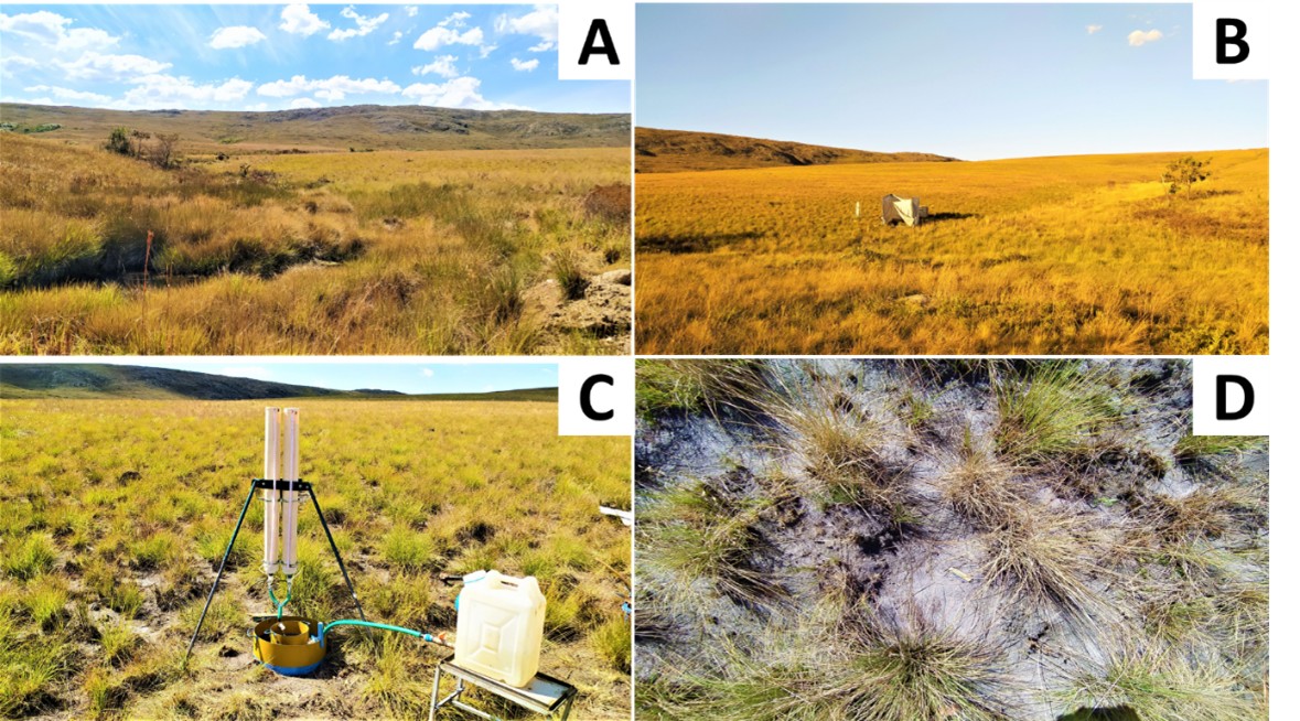
The vegetation covering the riparian zone consists almost entirely of grasses randomly arranged on the surface (Figure 3). Plants exhibited heights ranging from 20 to 40 cm. Scattered among these clumps, small native species spread sporadically over the area, forming a litter predominantly less than 40 centimeters in height.
Larger shrubs develop along the stream banks, with heights predominantly less than 1.5 meters. Due to their limited distribution and dispersion over a minimal portion of the terrain, they are not significant in the rest of the area.
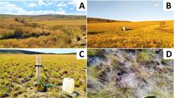
Riparian Zone Vegetation: Stream in the valley bottom (A); Experiment site in the study area (B); Infiltrometer in the clumps of grass (C); Scattered clumps (D).
The open, herbaceous vegetation, with small shrubs and abundance of grasses, characterizes the area as “campo limpo” phytophysiognomy. Due to these predominant species, distributed only near the stream, this indicates a selective environment.
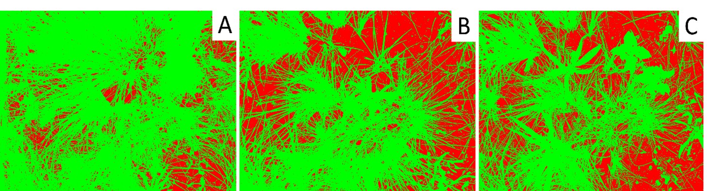
The vegetative composition, predominantly grasses with abundant but narrow leaf structures, provides cover for the soil (68.07%), with exposed soil only in areas without vegetation, between the clumps (Figure 4).
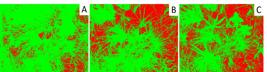
Relationship between vegetation cover and exposed soil in experimental sites. A - 16.60% exposed soil; B - 38.48% exposed soil; C - 40.71% exposed soil.
In addition to the characteristics cited, the vegetation cover also reflects a fire that occurred on the study slope 2 years before the experiments. The fire consumed structural and foliar parts of the plants as well as the surface litter, thereby reducing soil protection. This indicates that the environment requires time for complete recovery.
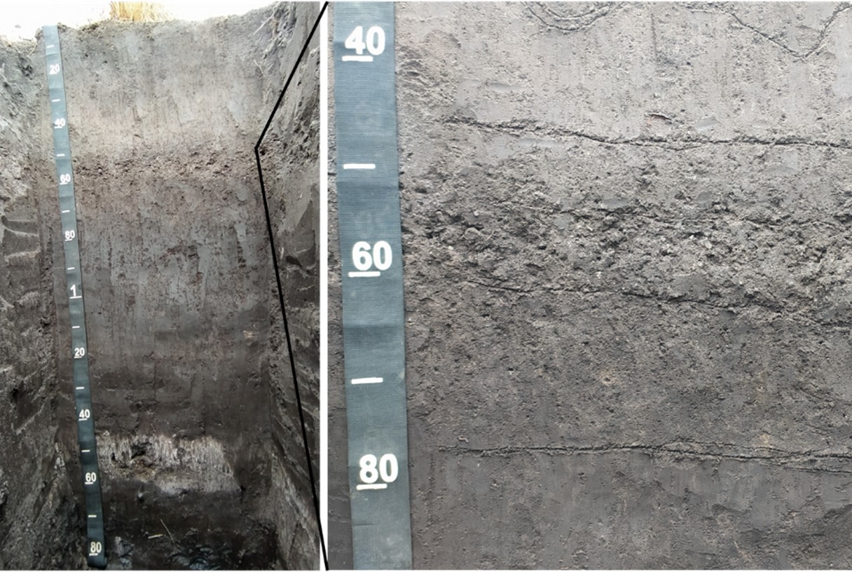
Overlaying the quartzitic rock, the riparian soil is deep (1.60 meters) compared to soils in mid-slope areas (20 centimeters) (Confessor et al., 2024a). Classified as Gleysol Melanic Ta Dystrophic neofluvisol (Figure 5), this soil is distributed throughout the hydromorphic environment, with pedogenetic processes linked to higher water presence imparting characteristics to the organic as well as the inorganic materials.

The soil is characterized by grayish-colored materials, with its horizons predominantly exhibiting massive and friable structures composed mainly of sandy fraction materials, with minimal presence of gravel throughout the horizons. This gravel, characterized by fragments of quartzitic rock, is found only along a thin strip between depths of 45 and 60 centimeters.
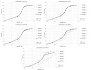
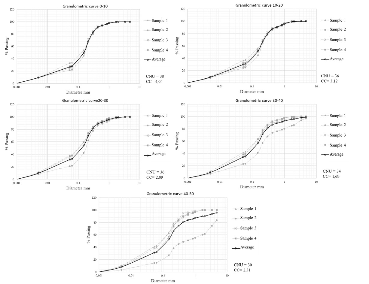
The granule size analysis reveals that throughout the profile, the soil exhibits homogeneous physical characteristics, with materials classified as “non-uniform” by the coefficient of non-uniformity (CNU) and graded poorly by the curvature coefficient (CC) (Figure 6).
The pale coloration of the profile indicates the occurrence of chemical reactions in the environment, derived from the saturation of the sandy soil matrix by water over a prolonged period, promoting the reduction and/or removal of oxidized pigmented elements such as Fe, altering the soil hue to paler colors (Pinheiro Júnior et al., 2020).
The saturated environment also aids in the fixation of organic matter, reducing its oxidation and producing greater storage. The accumulation of organic matter also contributes to the pigmentation of granules, inducing soil darkening (Valladares et al., 2008).
The clod structure also suggests the presence of water in the profile, as constant saturation prevents the formation of granular structures (Pinheiro Júnior et al., 2020). Water fills the soil voids, resulting in the movement of finer material among coarser material, rearranging granules to densify them.
The decomposition of organic matter under anaerobic conditions leads to the formation of humic substances, which also contribute to the cohesion of mineral granules (Baldotto; Baldotto, 2014). Furthermore, its decomposition by microorganisms results in the formation of compounds important for the cementation and stabilization of aggregated mineral granules due to their long carbon chain structure (Sampaio et al., 2012).
Despite exhibiting a clod structure, the values of total soil density (Dt) (Table 1) indicate that the soil in the area is not compacted, revealing values below the critical limit of 1.81 (Dt) as reported by Reichert et al. (2007), reflecting porosity values close to those considered optimal (0.50) by Kiehl (1979).
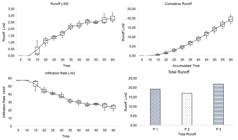
Regarding the data produced by the field equipment, the ring infiltrometer revealed an initial peak infiltration rate for the riparian soil of 225.99 mm/h (Figure 7), stabilizing after 50 minutes of testing and exhibiting a final steady infiltration rate (SIR) of 50.74 mm/h until the end of the experiments. The data demonstrated that the environment has a high infiltration capacity, with values above 30 mm/h classified as very high by Bernardo et al. (2006).
The variation in infiltration rate between the beginning and the end of the experiments was 78.18%, with a correlation curve among the collected values of R2= .60, indicating that even though there are high infiltration rates when exposed to water presence for long periods of time, this environment has its infiltration capacity considerably reduced.

The experiments involving the rainfall simulator revealed that after the onset of precipitation, surface runoff originated at 11:22 minutes, with an initial abstraction of 10.87 mm, accounting for 18.94% of the total precipitation over the entire experimental period (Figure 8). The delay in the onset of surface runoff, besides the elevated soil infiltration capacity, suggests an accumulation of water on the surface due to potential barriers created by the vegetation.
Clumps of grass distributed over the area impeded the propagation of surface flow, accumulating water through pooling. After saturation of the surface accumulation spaces, water flowed continuously over the plot, increasing in volume until the end of the experiments. This resulted in high correlation values for the runoff curve, R2 = 0.94, corresponding to 23.74% (13.62 liters) of the total precipitation.
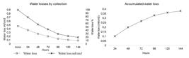
Following saturation, the riparian soil exhibited a water retention volume of .46 ml/cm3. Evaporation losses decreased steadily over time (R2 .94), with the highest values observed in the first 96 hours, during which 87.15% of the total evaporated volumes occurred.
At the end of six days, a total volume of .36 ml/cm3 had been evaporated, corresponding to 80.79% of all stored water (Figure 9). Thus, the soil exhibited a water retention capacity (WRC) of .08 ml/cm3, which is only 19.20% of its total storage capacity, indicating elevated regenerative capacity.
Systematization
Overall, the area exhibited a wide infiltration capacity, where the sandy composition of the soil's granulometric matrix reflected in the formation of environments with good porosity, contributing to high infiltration rates. However, after being saturated for long periods, the hydraulic conductivity of water in the soil reduced considerably, resulting in decreased infiltrated volumes.
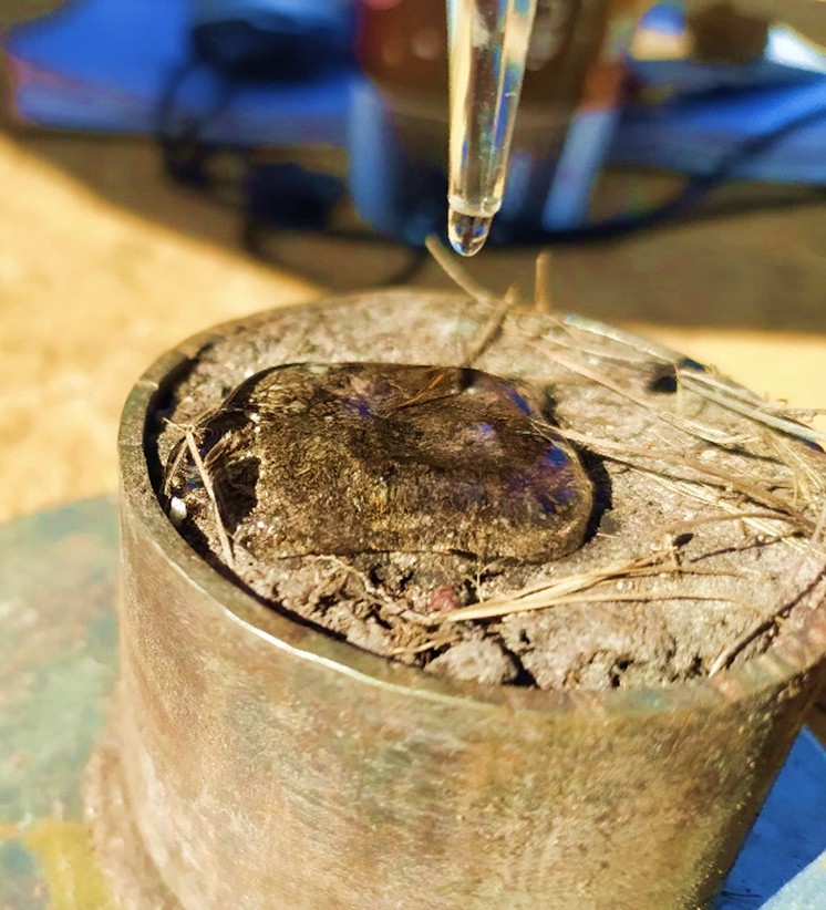
It was observed that when dry, the local soil exhibited hydrophobicity (Figure 10), which hindered infiltration, forming a water film on the surface during the initial moments of precipitation and accumulating water in the form of puddles in small irregularities of the terrain. After wetting, the repellence gradually ceased, allowing an increase in infiltrated volumes.
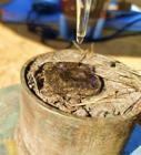
Water repellency is associated with the coating of soil mineral particles by hydrophobic organic substances (Jaramillo, 2004), being greater in surface horizons and decreasing with increasing depth as organic matter content also tends to decrease in deeper layers (Shakesby et al., 2000).
In addition to naturally incorporated organic matter, wildfires, as occurred two years before the study, are common in the area. Such events are responsible for generating physical and chemical changes in the soil, altering materials and producing substances that affect water movement.
The burning process increases soil density in its surface layer and the collapse of aggregates. This causes pore blockage through mineral alteration and ash deposition (Ketterings et al., 2002).
By products of the combustion process also reduce hydraulic conductivity as soil pores are filled with burnt matter and ashes produce a layer that coats the exterior of aggregates preventing water infiltration (Debano, 2000; Shakesby; Doerr, 2006).
Concurrently, the hydromorphic environment generates a greater accumulation of organic matter providing a larger quantity of repellent material. Frequent fluctuations in the water table level cause movements of humic particles throughout the riparian profile, aiding in coating the sandy mineral matrix with organic matter.
In addition to hydrophobicity, a delay in the formation of surface runoff was observed due to vegetative action. The predominantly clump vegetation cover creates obstacles for surface runoff, generating unevenness in the terrain which impedes flow. Water is stored on the surface providing more time for infiltration to occur. This process moistens the soil reducing surface hydrophobicity.
The position on the slope, with greater soil depth compared to surrounding areas, indicates that the site acts as a sediment deposition area. The sandy matrix with low gravel presence has a selective effect on deposited materials. The smaller particles have a low clay concentration, different from their source area at the top of the slope (Confessor et al., 2024b).
In this sense, despite repellence, clod structure, steep slope, and reasonable soil cover, the riparian zone exhibits high basic infiltration rates. This indicates potential to absorb intense rainfall. High rates of water loss by evaporation contribute to soil void spaces necessary for infiltration, releasing pores to absorb water of future rainfall, highlighting a dynamically hydrological environment.
CONCLUSION
The results reveal that the riparian zone under study exhibited elevated infiltration capacity, indicating that this area plays a crucial role in regulating hydrological processes, contributing to water storage and controlled distribution in the lower slope. Located near the drainage channel, it acts as a natural filter, potentially contributing to improving water quality in the stream by retaining sediments and any nutrients carried by flows from upstream slopes. The area serves as a barrier that can somewhat prevent floods and maintain a constant water supply for adjacent ecosystems.
Due to its more constant soil moisture, the riparian zone provides environments more apt to accommodate organic matter storage and consequently carbon. This process can contribute to preventing carbon release into the atmosphere and mitigating potential effects of climate change.
In this sense, the importance of preserving areas with attributes similar to those described in the present study is highlighted, as these environments provide important ecosystem services that can extend beyond their areas.
References
-
ATTANASIO, C. M.; GANDOLFI, S.; ZAKIA, M.; VENIZIANI, J.; LIMA, W. A importância das áreas ripárias para a sustentabilidade hidrológica do uso da terra em microbacias hidrográficas. Bragantia: boletim técnico do Instituto Agronômico do Estado de São Paulo, v. 71, n. 4, p. 493-501, 2013. Doi: 10.1590/S0006-87052013005000001
» https://doi.org/10.1590/S0006-87052013005000001 - BALDOTTO, M. A.; BALDOTTO, L. E. B. Ácidos húmicos. Revista CERES, 856-881, 2014. Doi: 10.1590/0034-737x201461000011
- BERNARDO, S.; SOARES, A. A.; MANTOVANI, E. C. Manual de irrigação. 8. ed. Atual. e Ampl. Viçosa: UFV, 2006. 625 p.
- CAMPBELL, G. S. Soil physics with basic: transport models for soil-plant systems. Elsevier: Amsterdam, the Netherlands, 1985.
-
CARVALHO, F.; CONFESSOR, J. G.; RODRIGUES, S. C. Utilização de simulador de chuvas para determinação do valor CN e abstração inicial na cultura do café em ambiente de cerrado brasileiro. Physis Terrae - Revista Ibero-Afro-Americana de Geografia Física e Ambiente, Guimarães, Portugal, v. 2, n. 2, p. 101-126, 2021. Doi: 10.21814/physisterrae.3083
» https://doi.org/10.21814/physisterrae.3083 -
CONFESSOR, J. G. Avaliação de processos erosivos hídricos em diferentes usos agrícolas, utilizando simulador de chuvas no ambiente de Cerrado. 2019. 187 f. Dissertação (Mestrado em Geografia) - Universidade Federal de Uberlândia, Uberlândia, 2019. Doi: 10.14393/ufu.di.2019.606
» https://doi.org/10.14393/ufu.di.2019.606 -
CONFESSOR, J. G. Dinâmica hidrogeomorfológica de vertentes do Chapadão do Diamante - Serra da Canastra - MG. 2023. 23 f. Tese (Doutorado em Geografia) - Universidade Federal de Uberlândia, Uberlândia. 2023. Doi: 10.14393/ufu.te.2023.70
» https://doi.org/10.14393/ufu.te.2023.70 -
CONFESSOR, J. G.; SILVA, L. L.; ARAÚJO, P. M. S. An assessment of water and soil losses in pastures of the Brazilian Savanna using simulated rainfall. Sociedade & natureza, 2022. Doi: 10.14393/SN-v34-2022-65618x
» https://doi.org/10.14393/SN-v34-2022-65618x -
CONFESSOR, J. G.; SILVA, L. L.; RODRIGUES, S. C. Dinâmica hídrica do solo de Fitofisionomia de Campo Limpo do Parque Nacional da Serra da Canastra-MG. Caderno de Geografia, v. 34, n. 76, 2024a. Doi: 10.5752/P.2318-2962.2024v34n76p286
» https://doi.org/10.5752/P.2318-2962.2024v34n76p286 -
CONFESSOR, J. G.; SILVA, L. L.; RODRIGUES, S. C. Hydraulic soil dynamics of the Sparse Cerrado Physiognomy in Chapadão do Diamante - serra da canastra (MG). Mercator, v. 23, 2024b. Doi: 10.4215/rm2024.e23006
» https://doi.org/10.4215/rm2024.e23006 -
DEBANO, L. F. The role of fire and soil heating on water repellency in wildland environments: a review. Journal of Hydrology. v. 231-232, p. 195-206, 2000. Doi: 10.1016/S0022-1694(00)00194-3
» https://doi.org/10.1016/S0022-1694(00)00194-3 - JARAMILLO, J. D. F. Repelencia al agua en suelos: con énfasis en Andisoles de Antioquia. Medellín: Universidad Nacional de Colombia. 2004. 197 p.
-
KETTERINGS, Q. M; VAN NOORDWIJK, M; BIGHAM, J. M. Soil phosphorus availability after slash and burn fires of different intensities in ruber agroforests in Sumatra, Indonesia. Agriculture Ecosystems & Environment. v. 92, n. 1, p. 37-48, 2002. Doi: 10.1016/S0167-8809(01)00287-0
» https://doi.org/10.1016/S0167-8809(01)00287-0 - KIEHL, E. J. Manual de edafologia: relações solo-planta. São Paulo: Ceres, 1979.
-
KLEIN, C.; KLEIN, V. A. Strategies to improve the retention and availability of soil water. Revista Eletrônica em Gestão, Educação e Tecnologia Ambiental, v. 19, n. 1, p. 21-29, 2015. Doi: 10.5902/2236117014990
» https://doi.org/10.5902/2236117014990 -
MORBIDELLI, R.; SALTALIPPI, C.; FLAMMINI, A.; CIFRODELLI, M.; PICCIAFUOCO, T.; CORRADINI, C.; GOVINDARAJU, R. S. In situ measurements of soil saturated hydraulic conductivity: Assessment of reliability through rainfall-runoff experiments, Hydrol. Process., v. 31, p. 3084-3094, 2017. Doi: 10.1002/hyp.11247
» https://doi.org/10.1002/hyp.11247 -
NAZAR, T. O Chapadão do Diamante na Serra da Canastra/MG, Brasil: caracterização geomorfológica e análise integrada do meio físico a partir de dados multifontes. 2018. 270 f. Tese (Doutorado em Geografia), Universidade Federal de Uberlândia, Uberlândia, 2018. Doi: 10.14393/ufu.te.2018.608
» https://doi.org/10.14393/ufu.te.2018.608 -
NAZAR, T. I. S. N.; RODRIGUES, S. C. Mapping and analysis of surface geocover in the Chapadão do Diamante - MG - Brazil. Mercator (Fortaleza. Online) , v. 18, p. 1-17, 2019a. Doi: 10.4215/rm2019.e18010
» https://doi.org/10.4215/rm2019.e18010 -
NAZAR, T.I.S.N.; RODRIGUES, S. C. Relevo do chapadão do diamante, Serra Da Canastra/Mg, Brasil: compartimentação e análise a partir dos aspectos geomorfométricos. Revista brasileira de geomorfologia, v. 20, p. 69-86, 2019b. Doi: 10.20502/rbg.v20i1.1300
» https://doi.org/10.20502/rbg.v20i1.1300 -
PERT, P. L.; BUTLER, J.; BRODIE, J.; BRUCE, C.; HONZÁK, M.; COROA, F.; METCALFE, D.; MITCHELL, D.; WONG, F. A catchment-based approach to mapping hydrological ecosystem services using riparian habitat: A case study from the Wet Tropics, Australia. Ecological complexity, v. 7, n. 3, p. 378-388, 2010. Doi: 10.1016/j.ecocom.2010.05.002
» https://doi.org/10.1016/j.ecocom.2010.05.002 -
PINESE JÚNIOR, J. F; CRUZ, L. M.; RODRIGUES, S. C. Monitoramento de erosão laminar em diferentes usos da terra, Uberlândia - MG. Sociedade & Natureza, v. 20, p. 157-175, 2008. Doi: 10.1590/S1982-45132008000200010
» https://doi.org/10.1590/S1982-45132008000200010 -
PINHEIRO JUNIOR, C. R.; PEREIRA, M. G.; SILVA NETO, E. C.; ANJOS, L. H. C.; FONTANA, A. Solos do Brasil: gênese, classificação e limitações ao uso. In: RIBEIRO, J. C. (org.). Ciências exatas e da terra: conhecimentos estratégicos para o desenvolvimento do país. Ponta Grossa: Atena, cap. 15, p. 183-199, 2020. Doi: 10.22533/at.ed.60220020715
» https://doi.org/10.22533/at.ed.60220020715 -
RAHMATI, M.; WEIHERMÜLLER, L.; VANDERBORGHT, J.; VEREECKEN, H. Development and analysis of the Soil Water Infiltration Global database. Earth System Science Data, v. 10, n. 3, p. 1237-1263, 2018. Doi: 10.5194/essd-10-1237-2018
» https://doi.org/10.5194/essd-10-1237-2018 - REICHERT, J. M.; SUZUKI, L. E. A. S.; REINERT, D. J. Compactação do solo em sistemas agropecuários e florestais: identificação, efeitos, limites críticos e mitigação. Tópicos Em Ciência Do Solo. v. 5, p. 49-134. Viçosa: Sociedade Brasileira de Ciência do Solo, 2007.
-
RODRIGUES, S. C.; AUGUSTIN, C.; NAZAR, T. Mapeamento Geomorfológico do Estado de Minas Gerais: uma proposta com base na morfologia. Revista brasileira de geomorfologia , v. 24, n. 1, 2023. Doi: 10.20502/rbg.v24i1.2233
» https://doi.org/10.20502/rbg.v24i1.2233 -
SAMPAIO, T. F.; GUERRINI, I. A.; BACKES, C.; HELIODORO, J. C. A.; RONCHI, H. S.; TANGANELLI, K. M.; CARVALHO, N.; OLIVEIRA, F. C. Lodo de esgoto na recuperação de áreas degradadas: efeito nas características físicas do solo. Revista Brasileira de Ciência Do Solo, v. 36, n. 5, p. 1637-1645, 2012. Doi: 10.1590/s0100-06832012000500028
» https://doi.org/10.1590/s0100-06832012000500028 - SANTOS, D.; VELLOSO, S.; FERREIRA FILHO, J. G. Determinação da taxa de infiltração de água no solo e lâmina infiltrada em latossolo vermelho-amarelo. Enciclopédia Biosfera, v. 11, n. 22, 2015.
- SANTOS, H. Sistema brasileiro de classificação de solos. Brasilia: EMBRAPA, 2018, 356 p.
-
SHAKESBY, R. A.; DOERR, S. H. Wildfire as a hydrological and geomorphological agent. Earth-Science Reviews. v. 74, p. 269-307, 2006. Doi: 10.1016/j.earscirev.2005.10.006
» https://doi.org/10.1016/j.earscirev.2005.10.006 -
SHAKESBY, R. A.; DOERR, S. H.; WALSH, R. P. D. The erosional impact of soil hydrophobicity: current problems and future research directions. Journal of Hydrology , v. 231, p. 178-191, 2000. Doi: 10.1016/S0022-1694(00)00193-1
» https://doi.org/10.1016/S0022-1694(00)00193-1 -
SILVA, G. A. Caracterização geomorfométrica de uma feição erosiva principiada por nascente no Chapadão Diamante, Serra da Canastra (MG). Caderno de Geografia , v. 30, n. 1, p. 52-76, 2020. Doi: 10.5752/p.2318-2962.2020v30nesp1p52-76
» https://doi.org/10.5752/p.2318-2962.2020v30nesp1p52-76 - SOUZA, J. S.; BASTOS, C. W. M. Mecânica dos Solos. NT Editora: Brasília, 31 p. 2015.
-
TAYLOR, R. G.; SCANLON, B.; DÖLL, P.; RODELL, M.; VAN BEEK, R.; WADA, Y.; TREIDEL, H. Ground water and climate change. Nature Climate Change, v. 3, n. 4, p. 322-329, 2012. Doi: 10.1038/nclimate1744
» https://doi.org/10.1038/nclimate1744 - TEIXEIRA, P. C.; DONAGEMMA, G. K.; FONTANA, A.; TEIXEIRA, W. G. Manual de métodos de análise de solo. 3. ed. Brasília, DF: Embrapa, 574 p. 2017.
- VALLADARES, G.S.; PEREIRA, M.G.; ANJOS, L.H.C.; EBELING, A.G. Caracterização de solos brasileiros com elevados teores de material orgânico. Magistra, v. 20, n. 1, p. 95-104, 2008.
-
FUNDING SOURCE
We would like to express our gratitude to CAPES for the doctoral scholarship granted to the first author, as well as for the partial funding of this research provided by CNPq, through PQ Scholarship 302924/2019-1 and Universal Grant 403412/2023-4, and the CAPES/UFU/PRINT Project 88887.311520/2018-00.

 Source:
  Source:
  Source:
  Source:
  Source:
  Source:
  Source:
  Source:
  Source:
  Source: