
 Impacts of the Homologation of Indigenous Lands on Mitigating Deforestation in the Legal Amazon
Abstract
The conservation of tropical forests has become a central topic in discussions on climate change, biodiversity, and territorial governance. In this context, Indigenous Lands have been recognized as important areas for environmental protection in the Brazilian Amazon. This study analyzes the effectiveness of the homologation process of these lands as an instrument for containing deforestation in the Legal Amazon. To this end, 22 Indigenous Lands officially recognized between 2009 and 2018 were analyzed using annual deforestation monitoring data obtained through remote sensing, provided by the PRODES/INPE system, and official information on territorial boundaries made available by FUNAI. The methodology was based on geoprocessing techniques in QGIS 3.34 software, through spatial intersection between deforestation polygons and Indigenous Land boundaries, covering the period from 2008 to 2024, which allowed for a comparison of deforestation patterns before and after the homologation process. The results indicate that 14 of the 22 Indigenous Lands analyzed showed a reduction in deforestation levels following formal territorial recognition, while 5 recorded a significant increase in vegetation suppression rates in the post-homologation period, and 3 presented deforestation occurrences only after homologation. These findings suggest that, although territorial recognition represents a relevant instrument for environmental protection, its effectiveness depends on the strengthening of public policies, institutional action, and continuous support for Indigenous communities in the management of their territories.
Keywords:
Geotechnologies; Territorial governance; Environmental policies; Deforestation monitoring
Resumo
A conservação das florestas tropicais tem se tornado tema central nas discussões sobre mudanças climáticas, biodiversidade e governança territorial. Nesse contexto, as Terras Indígenas são reconhecidas como importantes áreas de proteção ambiental na Amazônia brasileira. Este estudo analisa a eficácia no processo de homologação dessas terras como instrumento de contenção do desflorestamento na Amazônia Legal. Para isso, foram analisadas 22 terras indígenas homologadas entre 2009 e 2018, utilizando dados de monitoramento do desflorestamento obtidos por sensoriamento remoto e informações oficiais sobre os limites territoriais dessas áreas. A metodologia baseou-se em técnicas de geoprocessamento no software QGIS 3.34 por meio da intersecção espacial entre polígonos de desflorestamento e os limites das terras indígenas, abrangendo o período de 2008 a 2024, o que permitiu comparar os padrões de desflorestamento antes e após o processo de homologação. Os resultados indicam 14 das 22 TIs analisadas apresentaram redução nos níveis de desflorestamento após o reconhecimento formal do território, enquanto 5 apresentaram aumento expressivo nas taxas de supressão vegetal no período pós-homologação, e 3 apresentaram ocorrências de desflorestamento somente após a homologação. Esses resultados sugerem que, embora o reconhecimento territorial represente um instrumento relevante para a proteção ambiental, sua eficácia depende do fortalecimento de políticas públicas, da atuação institucional e do apoio contínuo às comunidades indígenas na gestão de seus territórios.
Palavras-chave:
Geotecnologias; Governança territorial; Políticas ambientais; Monitoramento do desflorestamento
INTRODUCTION
The Amazon region draws attention due to its vast biodiversity, cultural diversity, extensive river network, and its important role in regulating the global climate. As the largest tropical forest on the planet, its natural resources continue to be subjects of interest and exploitation, causing, over time, deep changes to the landscape, the composition of its population, and the prospects for regional development. This situation puts at risk the preservation of the natural and cultural elements that define the region (RAISG, 2020).
These changes are directly related to the dynamics of the global market and the development methods adopted in recent decades, which have posed significant obstacles to building sustainable models. There is an economic mindset focused on the relationship between means and ends, which often seems disconnected from the social and environmental aspects of development (Raworth, 2019). This mindset is linked to a historical legacy of the Brazilian colonial process and the growing commercialization of nature, shown by the expansion of agribusiness, mining and logging, livestock farming, and the appropriation of territories traditionally occupied by Indigenous peoples and traditional communities (Mesquita, 2020).
In Brazil, Indigenous Lands (ILs) cover 13% of the national territory and hold about 110 million hectares of native vegetation, representing roughly 20% of all the country’s native vegetation in 2020. Recognized as one of the main barriers to deforestation, these areas have lost only 1% of their native vegetation over the past 30 years, compared to a 21% reduction seen on private lands. This data highlights the strategic role of indigenous lands in environmental conservation and in slowing down the pressure from economic activities on natural resources (MAPBIOMAS, 2023).
Despite institutional advances in the demarcation and recognition of these territories, there is still a clear need to expand and consolidate the officially recognized areas. Several reports in the media and official documents point to recurring conflicts involving Indigenous peoples and different social actors, such as farmers, mining companies, land grabbers, agricultural producers, large businesses, and tourism activities, highlighting territorial disputes and pressures on these spaces (Dambrós, 2019; CIMI, 2025).
Thus, it becomes essential to use tools that can help in monitoring, controlling, and evaluating environmental impacts, making it possible to understand the dynamics of transformation and the processes of degradation or recovery of these areas (Ferreira; Pasa, 2015). Geotechnologies play a central role in optimizing analysis and decision-making processes. The integration of software, hardware, and specialized human resources enables the collection, processing, analysis, and representation of spatial information efficiently and accurately (Rosa, 2011).
These tools enable the analysis and interpretation of spatial data aimed at identifying degraded areas. This includes detecting illegal activities and monitoring processes like deforestation, mining, land grabbing, and other human pressures that directly affect indigenous lands and the conservation of natural ecosystems.
The monitoring of protected areas has been significantly improved by using advanced remote sensing and geoprocessing techniques, which make it possible to analyze large areas quickly and efficiently, cutting operational costs and boosting the ability to track changes in land cover and use (Correia et al., 2011).
Therefore, the study sought to analyze public policies related to the demarcation of Indigenous Lands (ILs), aiming to understand how their intermediate stages, especially the homologation stage, affect deforestation dynamics in these territories. Thus, the objective of this study is to assess whether the homologation of ILs contributes to reducing deforestation in their territories, through the analysis of spatial and temporal deforestation data in homologated areas in the Brazilian Legal Amazon (BLA).
THEORETICAL PRINCIPLES
Legal Amazon
Brazil stands out for its abundance of natural resources, including the Amazon Rainforest, which is the largest rainforest in the world. This biome is essential for key ecological processes like climate regulation, the water cycle, and maintaining global biodiversity (Shubart, 1983).
The Amazon is the largest tropical biome in the world, covering approximately 6.74 million km2 across nine South American countries: Brazil, Bolivia, Peru, Ecuador, Colombia, Venezuela, Guyana, Suriname, and French Guiana. This vast region is home to one of the most biodiverse ecosystems on the planet, shaped by the Amazon River basin, which accounts for nearly one-sixth of all the freshwater that flows in the oceans. It is a complex system marked by multiple ecosystems, abundant natural resources, low population density, and growing urbanization (WWF, 2025).
Unlike the Amazon as a forest biome, the Legal Amazon (LA) refers to a political-administrative boundary, established by the Brazilian government for the purposes of regional planning development. In Brazil, this region, defined by the Amazon Development Superintendence (Superintendência do Desenvolvimento da Amazônia - SUDAM), covers about five million km2, which represents 58.93% of the national territory (Figure 1).

Indigenous Lands
It was only four centuries after the start of Brazil’s colonization that the indigenous peoples’ land rights began to be officially recognized, both by the Portuguese State and the Brazilian State. Until then, indigenous peoples had no legal guarantees over their lands (Alencar, 2015). It was only with the enactment of the 1988 Federal Constitution, known as the Magna Carta, that indigenous rights started to be broadly and explicitly acknowledged. The Constitution included “Chapter VIII - Indigenous Peoples,” which established that Indigenous Lands (ILs) are portions of the national territory traditionally occupied by indigenous peoples, belonging to the Union and intended for the permanent use of these people (Silva; Pureza, 2019).
Among the legal advances related to the right to land and territory, the creation of the National Policy for Territorial and Environmental Management of Indigenous Lands (Política Nacional de Gestão Territorial e Ambiental de TI - PNGATI) stands out, established by Federal Decree No. 7,747 in June 2012. This policy aims to promote the protection, conservation, restoration, and sustainable use of the natural resources found on Indigenous Lands (BRASIL, 2012).
Several studies have highlighted the effectiveness of Indigenous Lands (ILs) as barriers against deforestation. Nolte et al. (2013), when comparing different types of protected areas, such as conservation units and community forests, showed that ILs achieved the highest rates of avoided deforestation, even under strong pressure from degrading activities around them. Similarly, Nepstad et al. (2006) emphasized the crucial role of these lands in containing the advance of the agricultural frontier. More recent data from the Socio-Environmental Institute (Instituto Socioambiental - ISA) back up this conclusion: ILs in the Amazon are responsible for preserving over 97.4 million hectares, and in the Cerrado, only 5.89% of the original vegetation has been deforested within these areas, compared to 54.4% outside them. Additionally, 82% of the monitored ILs showed lower deforestation rates than the surrounding areas (ISA, 2025).
The 1988 Constitution recognizes the so-called “original rights” of Indigenous peoples over the lands they traditionally occupy. That is, rights that existed before the very formation of the Brazilian state, acknowledging the history of colonial domination. These lands include areas where indigenous peoples live permanently, carry out their productive activities, and ensure the preservation of natural resources essential to their well-being. The demarcation of an Indigenous Land (IL) is merely declaratory, meaning it just serves to formalize the size of the occupied land, ensuring full effectiveness of the constitutional right. Protecting these lands is the responsibility of the Union (FUNAI, 2025).
The transitional provisions of the Constitution established a five-year deadline for completion of the demarcation of all Indigenous Lands in Brazil. However, this deadline was not met, and the demarcation process remains unfinished (FUNAI, 2025).
According to ISA, the demarcation of Indigenous Lands (ILs) is an administrative process aimed at guaranteeing the rights of indigenous peoples to their land, setting the boundaries of their territories, and protecting them from occupation by outsiders. Since the homologation of the Indigenous Statute in 1973, this formal recognition has been subject to follow an administrative procedure, regulated by an executive decree, which outlines the steps of the long demarcation process (ISA, 2023). The last important decree that regulated the demarcation process was Decree No. 1,775, from January 1996 (BRASIL, 1996).
Under the current legislation (BRASIL, 1988; BRASIL, 1973; BRASIL, 1996), ILs are classified into the following types:
-
Traditionally Occupied Indigenous Lands: These are lands permanently inhabited by Indigenous peoples, used for productive and cultural activities, well-being and physical reproduction, in accordance with their customs, habits, and traditions.
-
Indigenous Reserves: These are lands donated by third parties, acquired, or expropriated by the Union for the permanent possession of Indigenous people. They are also lands that belong to the Union’s assets, but they are not the same as lands of traditional occupation.
-
Public Lands: These are the lands owned by Indigenous communities and acquired through any legally recognized form or title.
For Traditionally Occupied Indigenous Lands, there are phases defined by Presidential Decree (Decree No. 1,775/1996) in the demarcation process. These phases are completed through an administrative process that only ends with the homologation and registration of the area under the Union’s name, ensuring all the rights of indigenous people and property owners within the area under demarcation throughout the process.
According to FUNAI, the demarcation process consists of the following phases:
-
Under Review: Conducting anthropological, historical, land ownership, environmental, and cartographic surveys.
-
Delimitation: Publication of the studies approved by the FUNAI Presidency in the Official Gazette.
-
Declaration: Analysis and decision by the Minister of Justice on the limits of ILs, with the publication of an official ordinance.
-
Homologation: Publication of the presidential decree with the georeferenced boundaries of the area.
-
Regulation: Notary registration of the ILs by the Union Heritage Secretariat (SPU).
-
Restriction: Areas temporarily protected due to the presence of isolated indigenous peoples.
According to the Indigenous Missionary Council (Conselho Indigenista Missionário - (CIMI, 2023), the process of demarcating Indigenous Lands in Brazil has proven to be slow and ineffective, even with the 1988 Federal Constitution establishing that all Indigenous Lands should be demarcated by 1993. Currently, Indigenous Lands are at different stages (Figure 2).

The process of recognizing ILs in LA has shown variations across different federal governments, considering the stages of delimitation, declaration, and homologation planned in the demarcation process (Table 1).
An analysis of IL demarcations in LA reveals a significant variation between governments, reflecting the influence of the political-institutional context. It is worth noting that the high numbers seen in the 1990s are largely linked to the backlog created by the 1988 Federal Constitution, which recognized indigenous lands rights and created accumulated demand for regularization. In this context, the governments of Fernando Henrique Cardoso and, later, the first two terms of Luiz Inácio Lula da Silva achieved the most progress.
Since 2011, there has been a gradual slowdown in the approval of Indigenous Lands (ILs). This process worsened during Bolsonaro’s government (2019-2022), a period in which no ILs were approved, making it the biggest halt in demarcations in recent decades. With the start of President Luiz Inácio Lula da Silva’s third term in 2023, the process was restarted, resulting in the approval of twenty ILs, as shown in Table 1.
STUDY AREA
The study area includes the ILs located in LA, covering approximately 1.15 million km2; representing 23% of LA’s territory and 98.25% of the total extent of all ILs in the country. The approved ILs account for most of the ILs with 1.06 million km2 (Figure 3).

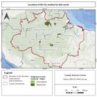
The map shows the spatial distribution of officially recognized ILs in the Brazilian LA, classified by the period of recognition between 1980 and 2024. A temporal analysis shows that the highest number of recognitions occurred between 1990 and 2000, a period predominant across most of the mapped area and represented by light orange. This is a direct reflection of the constitutional advances guaranteed by the 1988 Federal Constitution, which recognized the original rights of indigenous peoples over their lands. The previous period, from 1980 to 1990, shown in yellow, is focused on large ILs. Meanwhile, the approvals between 2000 and 2010, shown in dark orange, indicate a continuation of the indigenist policy. The most recent period, from 2010 to 2024, shown in dark red, has the lowest number of approvals, highlighting a significant slowdown in the demarcation process in recent decades, with ILs scattered throughout the territory. In this study, different ILs located in LA were analyzed (Figure 4 and Table 2).
APPLIED METHODOLOGY
This section details the methodological scheme used in this study, including the data used, the procedures adopted for analyzing deforestation in ILs in LA, and the products generated (Figure 5).

The flowchart also indicates the attributes associated with each data set, as well as the format of the information used, represented by icons that identify polygons (vector data), tabular data, and graphic results.
The deforestation data used in this study were obtained from PRODES (Monitoramento do Desmatamento da Floresta Amazônica Brasileira por Satélite) (INPE, 2022a). The system monitors deforestation across Legal Amazon using satellite imagery. It has been running since 1988 and calculates every year how much forest has been cut down, helping the government make decisions and create environmental policies. The system uses images from different satellites and only maps deforested areas larger than 6.25 hectares, with high accuracy. Also, its data is publicly available and widely used in studies, environmental agreements, and enforcement actions. PRODES uses an incremental and cumulative method: each year, only the new polygons of detected deforestation are recorded, but areas previously classified as deforested remain permanently marked in the database. In doing so, once an area is identified as deforested by PRODES, it never goes back to being categorized as forest in the system, regardless of any natural regeneration or later reforestation (INPE, 2019).
The data was acquired through the TerraBrasilis platform (INPE, 2022b). Initially, vector files in shapefile format related to LA were obtained, containing the boundary of the study area, as well as vector data from PRODES in geopackage format with information on accumulated deforestation up to 2007 and annual deforestation polygons for the period from 2008 to 2024.
In the context of this research, only the annual deforestation data from 2008 to 2024 were used, since the data accumulated up to 2007 does not allow identifying the specific year when deforestation occurred. This approach made it possible to analyze deforestation events in the LA region more precisely over time.
The boundaries of the ILs were obtained from the official website of the National Indigenous Foundation (Fundação Nacional dos Povos Indígenas - FUNAI), available in vector format (shapefile). However, it was found that the original file did not have the attribute for the year of approval of the ILs, which would make it impossible to apply temporal classification used in this study. To work around this limitation a supplementary tabular database, also provided by FUNAI, was used. This database contains information on the official homologation of each IL. Using the software QGIS 3.34 (QGIS Development Team, 2023), attributes were linked between the table and the vector layer of the ILs, using the field containing the IL code as the join key. This procedure resulted in a consolidated vector layer containing information on the IL name, territorial area, and year of homologation, making it possible to create the thematic map by periods.
Later, the deforestation polygons that intersect the analyzed Indigenous Lands (ILs) were selected. Then, the intersection tool in QGIS software was used to integrate the deforestation data with the information on the ILs. This process made it possible to link each deforestation polygon to its respective IL.
After the intersection, the areas of the resulting polygons were calculated. This step was necessary because the spatial clipping operation can cause the deforestation polygons to break up, changing their original areas.
The resulting data were converted into a tabular format, making it easier to analyze the information statistically. The generated table had columns with information about the year of deforestation, the name of the IL, the deforested area (km2), the year of homologation, and the total area of the IL (ha). In total, 3,886 deforestation polygons were identified in the areas analyzed.
Based on this data, the areas of deforestation were summed for each year within each IL, adding up the annual deforested area values and allowing for the analysis of the temporal dynamics of deforestation in the studied ILs.
To enable a comparative temporal analysis, ILs approved between 2009 and 2018 were selected. Choosing this time frame allowed us to assess deforestation behavior before and after the homologation process of these areas.
The year 2009 was chosen as the starting point of the analysis because it allows for observing the years before the homologation of the ILs selected, considering that annual PRODES data has been available since 2008. The period for analyzing homologations was limited up to 2018, since no new approvals of Indigenous Lands were recorded between 2019 and 2022. PRODES deforestation data, on the other hand, was analyzed up to 2024, allowing for the assessment of deforestation dynamics in the homologated ILs even in the years when no new demarcations occurred.
This strategy allowed the creation of a time series to analyze the behavior of deforestation before and after the official recognition of these areas. It is worth noting that, in the period analyzed (between 2008 and 2024), eight ILs showed no deforestation record and, therefore, were not included in the statistical analyses of this study.
RESULTS AND DISCUSSION
The homologation of ILs in Brazil represents the final stage of the territorial recognition process, giving legal security to indigenous peoples over their traditional territories. The dynamics of deforestation before and after homologation were evaluated (Figures 6 and 7).
The IL Lago do Correio did not show any deforestation before it was officially homologated. However, in 2019, 2022, and 2023, after its homologation, there were 3,887 hectares of deforestation recorded. The IL Prosperidade and Tabocal also only had deforestation recorded after being officially homologated.
The deforested area before and after land recognition was compared using boxplot graphs for eight IL (Figure 6). Overall, there seems to be a tendency of reduced deforestation after the law was enacted. Lands like Pequizal do Naruvôtu, Kayabi, Saruá, Arara da Volta Grande do Xingu, and Riozinho do Alto Envira show lower median and maximum values in the post-recognition period, suggesting that official recognition of the territory may have a positive effect on curbing environmental degradation.

Aggregated comparison of deforestation (in ha) for the periods before and after homologation
This positive trend, however, isn’t seen uniformly across the ILs analyzed. A notable case is the Cachoeira Seca Territory, located in the municipalities of Altamira, Placas, and Uruará (PA), which is noted as one of the most deforested territories in Brazil (ISA, 2025). The boxplots highlight this scenario: the average deforestation rate went from roughly 2,000 ha/year in the pre-homologation period to 3,500 ha/year after legal recognition, an increase of about 75%. The same happens, on a smaller scale, in the Tenharim Marmelos (Gleba B) and Trombetas/Mapuera ILs. This scenario indicates that legal protection alone is not enough to ensure the territorial integrity of these areas, reflecting external pressures such as land grabbing, illegal logging, and agricultural expansion. Data from Roraro et al. (2021) supports this assessment, classifying the ILs Cachoeira Seca and Tenharim Marmelos (Gleba B) with an environmental vulnerability of approximately 0.3 on a 0.5 scale, which tends to result in intensified deforestation and progressive compromise of the ecological integrity of these areas if effective protection and monitoring measures are not implemented.

Disaggregated comparison of the years with deforestation (in ha) before and after homologation
In ILs like Baía dos Guató, Barro Alto, Apurinã do Igarapé Mucuim, and Matintin, we see a reduction in deforestation after official recognition, with a sharp drop in the following years (Figure 7). These cases suggest that territorial recognition, combined with protection and monitoring measures, can have positive effects on controlling vegetation clearing (Brondízio, 2009).
The Mapari, Satemã, Cajuhiri Atravessado, Xipaya, and Zoe ILs see significant increases in deforestation after being officially recognized, as shown in Figure 7. For example, Mapari went from nearly zero in the pre-homologation period to about 1,300 ha afterwards, while Cajuhiri Atravessado jumped from less than 10 ha to around 120 ha. Zoe, on the other hand, hit a peak of about 225 ha post-homologation, higher than what was seen before its legal recognition.
This pattern goes against the initial expectation that ratification would immediately reduce deforestation. Scientific literature has already documented this phenomenon in other Brazilian ILs: ratification alone doesn’t guarantee that invasions, agricultural and livestock expansion, and deforestation will be contained, especially when it isn’t accompanied by effective enforcement and eviction actions. Indigenous lands in Brazil only become effective in controlling deforestation when full property rights and territorial protection are guaranteed to them (Baragwanath; Bayi, 2020).
Studies like the one by Alves, Lima, and Veloso (2022) point out that in the Apyterewa IL, located in São Félix do Xingu (PA), the accumulated deforestation up to 2018 reached 83,906 ha, equivalent to 10.85% of the territory. Deforestation grew by 576% between 2000 and 2005, slowed down after the official homologation in 2007, and then rose again by 216% between 2014 and 2018. Similarly, Turíbio et al. (2022) identified increased deforestation in the Paquiçamba and Arara ILs of the Volta Grande do Xingu between 2000 and 2020. They found a sharp acceleration starting in 2010, coinciding with the construction of the Belo Monte Hydroelectric Plant, highlighting the role of large infrastructure projects in worsening environmental degradation. Other studies also show changes in land use and reductions in vegetation cover in ILs, like in the case of the Xacriabá IL (Santos Júnior; Fernandes, 2014) and the Tapayuna IL (Marcelino; Mengue; Faria, 2022), where forest areas are being replaced by agricultural activities. Overall, these results show that effective protection in ILs depends not just on legal recognition, but also on the presence of public policies, enforcement, and territorial governance.
Studies point out that the effectiveness of protection in ILs depends on the coordination between territorial rights, state presence, indigenous governance, and ongoing monitoring and enforcement tools, like the use of remote sensing data (MAPBIOMAS, 2023; Nolte et al., 2013). Therefore, it is necessary to tie recognition to broader public policies, including support for community surveillance, institutional strengthening, and holding illegal actors involved in environmental degradation accountable.
The results indicate that this relationship isn’t direct or consistent. Although most of the analyzed ILs show a decrease in deforestation after legal recognition, a significant number of cases showed the opposite pattern, with an increase in vegetation clearing after homologation. In this way, the initial hypothesis that the homologation contributes to reducing deforestation was partially refuted: legal recognition was proved to be insufficient on its own to ensure territorial protection, with its effectiveness depending on the presence of enforcement, removal of non-Indigenous occupants, and complementary public policies. Focusing solely on the homologation process turned out to be limited for capturing the protection dynamics of these areas, suggesting that the protective effect might already appear in earlier stages of the demarcation process, such as identification, delimitation, and declaration, which points to a future research agenda on the effects of each stage on deforestation.
Even so, when compared to other land use and occupation categories, ILs stand out as the areas most affected by the spread of deforestation in Brazil. According to the data from MapBiomas, between 1985 and 2023, ILs, which account for 13% of the national territory, lost less than 1% of their native vegetation, while private properties saw destruction reach 28% over the same period. Of the total 281 million hectares converted by 2023, 60% are on private properties. In 2024, only 33% of Brazilian ILs recorded any deforestation events, and the total areas deforested represented just 1.3% of national deforestation, a 24% decrease compared to 2023. As highlighted by Bento et al. (2025), ILs play a key role in conserving the Amazon, helping maintain vegetation, soil moisture, and temperature, especially when located near conservation units.
Furthermore, this performance can be understood in light of the principle of surveillance discussed by Foucault (2014), which suggests that the constant possibility of being watched influences people’s behavior, regardless of the direct presence of the State. In the context of ILs, the action of forest guardians and the community surveillance practices carried out by the indigenous peoples themselves have a preventive effect on illegal activities, such as deforestation, land grabbing, and mining, reinforcing territorial control and environmental protection, especially in areas where state oversight is limited.
FINAL CONSIDERATIONS
After analyzing the ILs and historical deforestation records, it was possible to draw conclusions about the effects of homologation and the differences between various ILs. The data shows that deforestation patterns are quite varied, suggesting that formal protection status alone doesn’t guarantee effective conservation.
It is worth noting that ILs weren’t designed as direct environmental control tools, but as areas constitutionally guaranteed to Indigenous peoples. The lower rates of deforestation seen in these areas largely come from the close relationship between Indigenous peoples and their lands, based on traditional and sustainable land-use practices, as well as the active role these communities play as agents of territorial surveillance and defense, often recognized as true “guardians of the forest.” Their ongoing presence and knowledge of the land play a key role in keeping illegal pressures in check, beyond external environmental command and control mechanisms.
In general, ILs show greater resilience against deforestation pressure compared to private properties and, in some cases, certain Conservation Units (CUs), as pointed out by MapBiomas (2023) and ISA (2018; 2025). They indicate that ILs are responsible for preserving more than 97 million hectares in the Amazon, with deforestation rates significantly lower than those in unprotected areas. This pattern reinforces the strategic role of these areas not only in preserving biodiversity and mitigating climate change but also in maintaining sustainable traditional ways of life.
However, the results indicate that homologation as a stage in the demarcation process, while relevant, is not the single most decisive factor in containing deforestation. Focusing solely on this stage doesn’t fully capture the protection dynamics of these areas, since institutional recognition begins in earlier stages of the demarcation process, such as identification, delimitation, and declaration (ISA, 2008; Qin et al., 2023). It is suggested, therefore, that future studies investigate the effects of each stage of the demarcation process on deforestation dynamics, to better understand exactly when the protective effect is most noticeable.
This dynamic shows that simply giving ILs legal recognition isn’t enough to ensure its ecological integrity. The effectiveness of protection relies on ongoing public policies, strengthening environmental institutions, and, above all, respecting and supporting the land management practices led by indigenous communities themselves. Thus, making sure ILs are conserved and stopping deforestation requires more than just legal recognition; it demands strong enforcement mechanisms and valuing indigenous leadership in the defense of their territories.
DATA AVAILABILITY
The data that underpin the results of this study may be made available by the corresponding author, upon duly justified request. [Rafael Dias Franco de Godoy].
References
- ALENCAR, A. V. S. Evolução histórica dos direitos indígenas. Âmbito Jurídico, Rio Grande, v. XVIII, n. 132, 2015.
-
ALVES, P. H. C. dos S.; LIMA, E. S. de; VELOSO, G. A. Dinâmica do desflorestamento na Terra Indígena Apyterewa mediante a aplicação de técnicas de sensoriamento remoto. Boletim Paranaense de Geociências, Curitiba, PR, v. 80, n. 1, 2022. Doi: 10.5380/geo.v80i1.82790
» https://doi.org/10.5380/geo.v80i1.82790 -
BARAGWANATH, K.; BAYI, E. Collective property rights reduce deforestation in the Brazilian Amazon. Proceedings of the National Academy of Sciences, Washington, v. 117, n. 34, p. 20495-20502, 2020. Doi: 10.1073/pnas.1917874117
» https://doi.org/10.1073/pnas.1917874117 -
BENTO, L. L.; RIBEIRO, H. J.; KOPP, K. A. Análise de uso e cobertura da terra e índices de diferença normalizada de vegetação e água em terras indígenas e entorno na região hidrográfica da Amazônia. Sociedade & Natureza, Uberlândia, MG, v. 37, e74902, 2025. Doi: 10.14393/SN-v37-2025-74902
» https://doi.org/10.14393/SN-v37-2025-74902 -
BRASIL. Lei nº 6.001, de 19 de dezembro de 1973. Dispõe sobre o Estatuto do Índio. Diário Oficial da União, Brasília, DF, 1973. Disponível em: https://www.planalto.gov.br/ccivil_03/leis/l6001.htm Acesso em: 21 set. 2023.
» https://www.planalto.gov.br/ccivil_03/leis/l6001.htm -
BRASIL. [Constituição (1988)]. Constituição da República Federativa do Brasil de 1988. Brasília, DF: Presidência da República, 1988. Disponível em: https://www.planalto.gov.br/ccivil_03/constituicao/constituicao.htm Acesso em: 28 fev. 2023.
» https://www.planalto.gov.br/ccivil_03/constituicao/constituicao.htm -
BRASIL. Decreto nº 1.775, de 8 de janeiro de 1996. Dispõe sobre o procedimento administrativo de demarcação das terras indígenas e dá outras providências. Diário Oficial da União , Brasília, DF, 1996. Disponível em: https://www.planalto.gov.br/ccivil_03/decreto/d1775.htm Acesso em: 28 fev. 2023.
» https://www.planalto.gov.br/ccivil_03/decreto/d1775.htm -
BRASIL. Decreto n. 7.747, de junho de 2012. Institui a Política Nacional de Gestão Territorial e Ambiental de TI - PNGATI. Diário Oficial da União , Brasília, DF, 2012. Disponível em: https://www.planalto.gov.br/ccivil_03/_ato2011-2014/2012/decreto/d7747.htm Acesso em: 21 set. 2023.
» https://www.planalto.gov.br/ccivil_03/_ato2011-2014/2012/decreto/d7747.htm - BRONDÍZIO, E. S. Análise intra-regional de mudanças do uso da terra na Amazônia. In: MORAN, E. F.; OSTROM, E. (org.). Ecossistemas florestais: interação homem-ambiente. São Paulo: Senac, 2009.
-
CONSELHO INDIGENISTA MISSIONÁRIO (CIMI). TI. 2023. Disponível em: https://cimi.org.br/terras-indigenas /. Acesso em: 22 mai. 2023.
» https://cimi.org.br/terras-indigenas -
CONSELHO INDIGENISTA MISSIONÁRIO (CIMI). Relatório Violência Contra os Povos Indígenas no Brasil: dados de 2024. 22. ed. Brasília: CIMI, 2025. Disponível em: https://cimi.org.br Acesso em: 19 mai. 2026.
» https://cimi.org.br - CORREIA, M. R. D.; BATISTA, D. C. L.; ARAUJO, R. L. C. de. Monitoramento do desflorestamento nas TIs do sul do Amazonas: uma abordagem entre a vetorização manual e a classificação automática. In: SIMPÓSIO BRASILEIRO DE SENSORIAMENTO REMOTO, 15., 2011, Curitiba. Anais [...]. Curitiba: INPE, 2011. p. 2920-2927.
-
DAMBRÓS, C. Contexto histórico e institucional na demarcação de TI no Brasil. Revista NERA, Presidente Prudente, SP, v. 22, n. 48, p. 174-189, 2019. Doi: 10.47946/rnera.v0i48.6371
» https://doi.org/10.47946/rnera.v0i48.6371 -
FERREIRA, A. L. S.; PASA, M. C. Use of geotechnology in deforestation monitoring in the Pantanal Mato-grossense. Advances in Forestry Science, v. 2, n. 2, p. 41-47, 2015. Doi: 10.34062/afs.v2i2.2358
» https://doi.org/10.34062/afs.v2i2.2358 - FOUCAULT, M. Vigiar e punir: nascimento da prisão. 42. ed. Petrópolis: Vozes, 2014.
-
FUNDAÇÃO NACIONAL DOS POVOS INDÍGENAS (FUNAI). Página inicial. Brasília, DF: FUNAI, 2025. Disponível em: https://www.gov.br/funai/pt-br Acesso em: 20 jul. 2024.
» https://www.gov.br/funai/pt-br -
INSTITUTO BRASILEIRO DE GEOGRAFIA E ESTATÍSTICA (IBGE). Estrutura Territorial. Rio de Janeiro: IBGE, 2025. Disponível em: https://www.ibge.gov.br/geociencias/organizacao-do-territorio/estrutura-territorial.html Acesso em: 25 abr. 2023.
» https://www.ibge.gov.br/geociencias/organizacao-do-territorio/estrutura-territorial.html -
INSTITUTO NACIONAL DE PESQUISAS ESPACIAIS (INPE). Metodologia PRODES/DETER. São José dos Campos: INPE, 2019. Disponível em: http://www.obt.inpe.br/OBT/assuntos/programas/amazonia/prodes/pdfs/Metodologia_Prodes_Deter_revisada.pdf Acesso em: 23 jul. 2023.
» http://www.obt.inpe.br/OBT/assuntos/programas/amazonia/prodes/pdfs/Metodologia_Prodes_Deter_revisada.pdf -
INSTITUTO NACIONAL DE PESQUISAS ESPACIAIS (INPE). Monitoramento da Floresta Amazônica Brasileira por Satélite. São José dos Campos: INPE , 2022a. Disponível em: http://www.obt.inpe.br/OBT/assuntos/programas/amazonia/prodes Acesso em: 10 ago.2023.
» http://www.obt.inpe.br/OBT/assuntos/programas/amazonia/prodes -
INSTITUTO NACIONAL DE PESQUISAS ESPACIAIS (INPE). TerraBrasilis: plataforma de dados geográficos. São José dos Campos: INPE , 2022b. Disponível em: http://terrabrasilis.dpi.inpe.br/ Acesso em: 05 jun. 2023.
» http://terrabrasilis.dpi.inpe.br/ -
INSTITUTO SOCIOAMBIENTAL (ISA). Almanaque Brasil Socioambiental. 2. ed. São Paulo, 2008. Disponível em: https://acervo.socioambiental.org/acervo/publicacoes-isa/almanaque-brasil-socioambiental-2008 Acesso em: 20 set. 2024.
» https://acervo.socioambiental.org/acervo/publicacoes-isa/almanaque-brasil-socioambiental-2008 -
INSTITUTO SOCIOAMBIENTAL (ISA). Organizações indígenas e indigenistas alertam para urgência de retirar invasores da Terra Indígena Cachoeira Seca, no Pará. São Paulo, 2025. Disponível em: https://www.socioambiental.org/noticias-socioambientais/organizacoes-indigenas-e-indigenistas-alertam-para-urgencia-de-retirar Acesso em: 19 mai. 2026.
» https://www.socioambiental.org/noticias-socioambientais/organizacoes-indigenas-e-indigenistas-alertam-para-urgencia-de-retirar -
INSTITUTO SOCIOAMBIENTAL (ISA). Relatório de Atividades 2017. São Paulo. 2018. Disponível em: https://www.socioambiental.org Acesso em: 20 set. de 2024.
» https://www.socioambiental.org -
INSTITUTO SOCIOAMBIENTAL (ISA). TI no Brasil. 2023. Disponível em: https://terrasindigenas.org.br/pt-br/brasil Acesso em: 22 mai. 2023.
» https://terrasindigenas.org.br/pt-br/brasil -
MAPBIOMAS. TIs contribuem para a preservação das florestas. 2023. Disponível em: https://mapbiomas.org/terras-indigenas-contribuem-para-a-preservacao-das-florestas Acesso em: 13 mai. 2023.
» https://mapbiomas.org/terras-indigenas-contribuem-para-a-preservacao-das-florestas -
MARCELINO, G. L. S.; MENGUE, V. P.; FARIA, C. S. de . Análise multitemporal e mudanças no uso e cobertura do solo: um olhar para as TI no Mato Grosso. Revista de Geografia. Recife, v. 39, n. 3, p. 145-164, 2022. Doi: 10.51359/2238-6211.2022.254551
» https://doi.org/10.51359/2238-6211.2022.254551 -
MESQUITA, B. A. de. A. A questão ambiental na contemporaneidade: conflitos socioambientais, garantias constitucionais e a efetividade das políticas públicas em debate - Entrevista especial com Dimas Floriani. Revista de Políticas Públicas, São Luís, v. 24, n. 1, p. 286-301, 2020. Doi: 10.18764/2178-2865.v24n1p286-301
» https://doi.org/10.18764/2178-2865.v24n1p286-301 -
NEPSTAD, D.; SCHWARTZMAN, S.; BAMBERGER, B.; SANTILLI, M.; RAY, D.; SCHLESINGER, P.; LEFEBVRE, P.; ALENCAR, A.; PRINZ, E.; FISKE, G.; ROLLA, A. Inhibition of Amazon deforestation and fire by parks and indigenous lands. Conservation Biology, v. 20, p. 65-73, 2006. Doi: 10.1111/j.1523-1739.2006.00351.x
» https://doi.org/10.1111/j.1523-1739.2006.00351.x -
NOLTE, C.; AGRAWAL, A.; SILVIUS, K. M.; SOARES-FILHO, B. Governance regime and location influence avoided deforestation success of protected areas in the Brazilian Amazon. Proceedings of the National Academy of Sciences , v. 110, n. 13, p. 4956-4961, 2013. Doi: 10.1073/pnas.1214786110
» https://doi.org/10.1073/pnas.1214786110 -
QGIS DEVELOPMENT TEAM. QGIS Geographic Information System. Versão 3.34. Open Source Geospatial Foundation Project, 2023. Disponível em: https://qgis.org Acesso em: 06 jun. 2023
» https://qgis.org -
QIN, Y.; XIAO, X.; LIU, F.; SILVA, F. de S. e; SHIMABUKURO, Y.; ARAI, E.; FEARNSIDE, P. M. Forest conservation in Indigenous territories and protected areas in the Brazilian Amazon. Nature Sustainability, v. 6, p. 295-305. 2023. Doi: 10.1038/s41893-022-01018-z
» https://doi.org/10.1038/s41893-022-01018-z -
REDE AMAZÔNICA DE INFORMAÇÃO SOCIOAMBIENTAL GEORREFERENCIADA (RAISG). Amazônia sob pressão. 2020. Disponível em: http://www.amazoniasocioambiental.org Acesso em: 06 abr. 2023.
» http://www.amazoniasocioambiental.org - RAWORTH, K. Economia Donut: uma alternativa ao crescimento a qualquer custo. Tradução de George Schlesinger. Rio de Janeiro: Zahar, 2019.
-
RORARO, A.; ESCADA, M. I. S.; CÂMARA, G.; PICOLI, M.; VERSTEGEN, J. Environmental vulnerability assessment of Brazilian Amazon Indigenous Lands. Environmental Science & Policy, v. 124, p. 43-53, 2021. Doi: 10.1016/j.envsci.2021.06.014
» https://doi.org/10.1016/j.envsci.2021.06.014 -
ROSA, R. Geotecnologias na Geografia aplicada. Revista do Departamento de Geografia, v. 16, p.81-90. 2011. Doi: 10.7154/RDG.2005.0016.0009
» https://doi.org/10.7154/RDG.2005.0016.0009 - SANTOS JÚNIOR, V. J.; FERNANDES, F. H. S. Uso do geoprocessamento no monitoramento da cobertura vegetal da Terra Indígena dos Xakriabá, no norte do estado de Minas Gerais. In: CONGRESSO BRASILEIRO DE GEOGRAFIA POLÍTICA, GEOPOLÍTICA E GESTÃO DO TERRITÓRIO, 1., 2014, Rio de Janeiro. Anais [...]. Porto Alegre: Letra1; Rio de Janeiro: REBRAGEO, 2014.
- SHUBART, H. O. R. Ecologia e utilização das florestas. In: SALATI, Eneas; SHUBART, Herbert; JUNK, Wolfgang. Amazônia: desenvolvimento, integração e ecologia. Ed. Brasiliense. São Paulo. 1983.
-
SILVA, G.; PUREZA, M. G. B. A demarcação de TI na Amazônia Legal. Revista NUPEM, v. 11, n. 22, p. 43-53. 2019. Doi: 10.33871/nupem.v11i22.608
» https://doi.org/10.33871/nupem.v11i22.608 -
TURÍBIO, L.; VELOSO, G. A.; LOBATO, M. Análise do índice de desflorestamento das TIs Paquiçamba e Arara da Volta Grande do Xingu, da área diretamente afetada pela UHE Belo Monte entre os anos de 2000 e 2020. Universidade e Meio Ambiente, v. 7, n. 2, p. 30-44. 2022. Doi: 10.18542/reumam.v7i2.13938
» https://doi.org/10.18542/reumam.v7i2.13938 -
WWF-BRASIL. Amazônia. Brasília: World Wide Fund for Nature Brasil, 2025. Sítio Eletrônico. Disponível em: https://www.wwf.org.br/natureza_brasileira/biomas/bioma_amazonia /. Acesso em: 25 set. 2025.
» https://www.wwf.org.br/natureza_brasileira/biomas/bioma_amazonia

 Source:
 Source:
 Source:
 Source:
 Source: Prepared by the authors (2025).
 Note: The year the IL was homologated is listed in the title of each chart. Source: Elaborated by the authors (2025) from data by
 Source: Elaborated by the authors (2025) from data by