
 Evapotranspiration Behavior of Eucalyptus Plantations Compared to Other Land Uses and Land Covers in the Semiarid Zone of Brazil - South America
Abstract
Water consumption by evapotranspiration (ET) of eucalyptus plantations is a concern widely addressed worldwide. However, in the semiarid region of Brazil, a region characterized by recurring water deficit, there is a gap in the knowledge on the effects of eucalyptus plantations on ET dynamics. Therefore, this study aimed to compare the ET rates of eucalyptus to native forests, savannas (Cerrado), dry woodlands (caatingas), pastures, and croplands in the Brazilian semiarid region (BSR). The methodological structure followed the use of remote sensing techniques and statistical tests. From the Google Earth Engine (GEE) platform, monthly and annual ET images for 2022 were obtained from the MOD16A2 product. The results of this study indicated that eucalyptus had significantly higher ET rates (Kruskal-Wallis test followed by the Dunn test; p-value <0.05) compared to most classes. Exceptionally, native forests (Atlantic Forest) exhibited statistically similar (p-value >0.05) water consumption to eucalyptus. Worryingly, eucalyptus, as well as crops, maintained high ET rates during the dry season in the study region. These findings may inform water planning strategies in the Brazilian semiarid region, especially by indicating environmentally sensitive areas for high-impact eucalyptus plantations, where such activity should be restricted. Thus, this study provides substantial information for more sustainable agro-environmental development in semiarid zones.
Keywords:
Brazilian semiarid region; Remote sensing; Water consumption; Forestry
INTRODUCTION
Evapotranspiration (ET) refers to the transfer of water from the soil to the atmosphere, a crucial component of the hydrological cycle. ET is highly dependent on climatic elements (e.g., air humidity, temperature, solar radiation, and soil water availability), and surface characteristics associated with vegetation phenology and land use and land cover (LULC) (Allen et al., 2011; Zhang et al., 2016). These factors give rise to different ET patterns around the world. However, this is most evident in semiarid zones, as they are lands with high temperatures and low water availability, which substantially reduce ET rates (Yang et al., 2019). In addition to preexisting climatic conditions, anthropogenic effects are prominent in the behavior of ET rates in semiarid zones through LULC dynamics (Li et al., 2022).
In the Brazilian Semiarid Region (BSR), for example, previous studies have suggested substantial changes in the natural dynamics of ET due to the intensification of human activities in this zone (Santos et al., 2024). The rapid growth of irrigated agriculture has been one of the most impacting processes in the BSR, mainly due to the excessive use of water during the dry season (Andrade et al., 2021). The replacement of native vegetation with pastures abruptly reduces ET, undermining natural cooling mechanisms and altering the hydrological regime, thereby intensifying surface and atmospheric warming (Jardim et al., 2022).
The behavior of evapotranspiration (ET) in Brazil’s semi-arid regions is well documented in various studies. However, ET rates for some land use and land cover (LULC) classes are yet to be fully clarified. Notably, eucalyptus plantations are intensely debated. While some studies report higher ET for eucalyptus compared to other LULC classes (Ferraz et al., 2019; Mattos et al., 2019; Adorno et al., 2021), others find no significant difference (Lima, 1990; Almeida; Soares, 2003; Cristiano et al., 2015; Silva et al., 2015). Furthermore, most studies focus on areas with higher precipitation levels than the BSR, making the potential impact of eucalyptus plantations on ET in more water-stressed areas even more significant (Barbosa, 2024). This needs further exploration, especially considering the rapid expansion of eucalyptus in the region (1,417.85 km² year-¹) (Souza et al., 2020).
Considering the challenges of limited coverage of meteorological stations in the study area (21 automatic and 6 conventional) (INMET, 2025), remote sensing emerges as a highly effective approach for ET studies. In recent decades, platforms such as Google Earth Engine have enabled rapid processing of extensive datasets, allowing researchers to capture the spatial and temporal variability of ET with unprecedented detail (Bhattarai; Wagle, 2021). This technological advancement, exemplified by the widespread use of the MOD16A2 product from MODIS, facilitates a robust analysis of phenological variations across different LULC classes (Li et al., 2017). Its wide spatial range and high temporal resolution provide in-depth insights into LULC phenological variations (Li et al., 2017). Validated against meteorological stations, it demonstrates 86% accuracy on a global scale (Ruhoff et al., 2013).
This study investigates the spatial and temporal dynamics of evapotranspiration (ET) across key land use and land cover (LULC) classes in the Brazilian Semiarid Region (BSR), with a focus on the water consumption patterns of eucalyptus plantations. By elucidating the interplay between land cover changes and ET variability in a data-sparse, water-stressed environment, our findings aim to inform sustainable water management strategies and land use planning in semi-arid ecosystems.
MATERIALS AND METHODS
Study Area
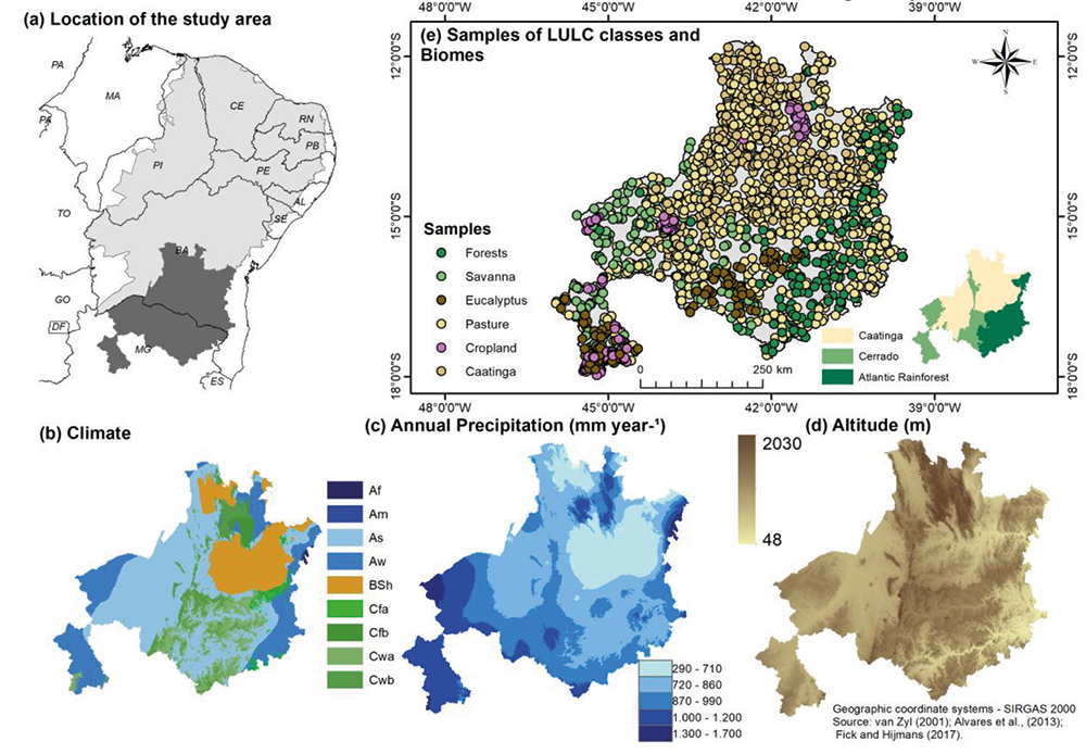
The study region comprises the northern portion of the state of Minas Gerais and the south-central part of Bahia (latitude: 12° to 18°S and longitude: 39° to 48°W) (Figure 1a), which concentrates most of the eucalyptus plantations in the BSR (approximately 3.984,11 km² in 2022). This area corresponds to 1.62% of the BSR, with 200 municipalities and a population of 3,853,433 million inhabitants (IBGE, 2010). The region has multiple LULCs, such as dense forests (12.99%), savannas (14.43%, Cerrado biome), caatingas (22.79%), pastures (37.80%), croplands (6.62%), and eucalyptus plantations (1.62%).
According to the Köppen classification, there are five climate types in the region: the predominant type is As (tropical hot and humid) (Figure 1b); Bsh (hot semiarid) in the central-northern part; Cwa (dry-winter humid subtropical climate) and Cwb (dry-winter subtropical highland climate) in the southeastern part; and Aw (tropical with dry winters) in the extreme west and east. These climatic types are characterized by a pronounced irregularity in the distribution of precipitation and a marked seasonality (Barbosa, 2024). Annual precipitation has a range of 1410 mm year-¹, with the highest values (1000 mm year-¹ to 1700 mm year-¹) distributed in the southwest portion and the lowest ranges (290 mm year-¹ to 700 mm year-¹) concentrated in the extreme north and northeast of the region (Figure 1c). The wet season occurs between December and April, while the dry season extends from July to October (Marengo et al., 2017).
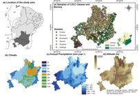
Location map of the study area: (a) Brazilian semiarid region (light gray) and the area considered in the present study (dark gray); (b) different climate types according to Köppen’s classification; (c) distribution of annual precipitation (1970 - 2000); (d) altimetric variations; (e) LULC samples used, as well as the Brazilian biomes of the region according to the Instituto Brasileiro de Geografia e Estatística (IBGE - Brazilian Institute for Geography and Statistics)
The elevation in the region ranges from 48 to 2,030 meters, with an average of 330 meters (Figure 1d). The landscape is characterized by a predominance of flattened and depressed surfaces, interspersed with elevated plateaus and expansive plains (Moro et al., 2024). This diverse topography fosters the coexistence of three distinct biomes: Caatinga, Cerrado, and Atlantic Forest (Ab’Sáber, 2003; Figure 1e).
In the Caatinga (thorny and deciduous woodlands) and Cerrado (a savannic ecosystem with a grass layer) biomes, the vegetation is strongly influenced by the marked seasonality (Pennington et al., 2018). Both biomes present multiple phytophysiognomies with varying levels of tree height, density, biomass and canopy connectivity, from open grasslands in the savannic formations of the Cerrado to tall deciduous forests (“arboreal caatinga”) (Pennington et al., 2018). These areas also possess pasture systems with exotic, African grasses (e.g., Brachiaria) and large projects of irrigated agriculture (such as the Jaíba project) which are an important component of the regional economy.
In the eastern portion, where Cerrado and Atlantic Forest coexist on the plateaus, humid forests dominate, with occasional occurrence of savannic formations of the Cerrado (Figure 1e). This area is also marked by the presence of eucalyptus plantations, predominantly the Eucalyptus grandis species. Eucalyptus cultivation expanded considerably and received government incentives to meet the demand for wood for the steel, paper and pulp industries (Leite et al., 2012).
Land use and land cover samples
Samples were acquired for the six most representative LULC classes in the study region for the year 2022: cropland (n = 140), Caatinga (n = 345), eucalyptus (n = 115), forests (n = 164), pastures (n = 739) and Cerrado (hereafter referred to as “savanna”) (n = 167) (Figure 1e). The sample database was obtained through the Mapbiomas project (Souza et al., 2020; MapBiomas, 2023). It is worth noting that the difference between the number of samples (n) is associated with the dimensional disproportion of the area of each LULC classes.
These samples were produced and validated by Mapbiomas analysts and experts through inspection of images from the Landsat satellite series on the Visual Inspection Tool (TVI) platform. To increase the accuracy of the samples, a visual inspection was performed using high-resolution images obtained through the HCMGIS plugin in QGIS software (QGIS, 2024). This procedure identified and resized samples located at the edges of the LULC classes.
Satellite-derived data
ET estimates were obtained using the MOD16A2 version 061 product from the MODIS sensor and Terra satellite (Running et al., 2017). This product is provided by NASA with a spatial resolution of 500 meters and a revisit time of every 8 days, which can reach 5-6 days depending on the year. The MOD16A2 product provides five layers in GeoTIFF format: two layers of latent heat flux (average and total), which represents the energy used to convert water from the liquid state to vapor; the total potential evapotranspiration, that is, the water transferred to the atmosphere considering only the optimal climatic conditions; the evapotranspiration quality control image; and the total evapotranspiration (ET), which includes the water transferred to the atmosphere considering the climatic conditions and phenological attributes of the LULC classes (Running et al., 2017).
The formulation of ET estimated from MOD16A2 is based on the logic of the Penman-Monteith equation, combining biophysical attributes such as albedo, leaf area index, enhanced vegetation index, and daily meteorological data from NASA Global Modeling and Assimilation Office (GMAO) (Running et al., 2017). This product was chosen due to its efficiency, which has been widely tested in different parts of the globe, as well as its technical quality, ensured by cloud removal and atmospheric correction procedures (Ruhoff et al., 2013; Running et al., 2017).
The images were obtained on a daily scale for the 12 months of the year 2022. All available images for each month were selected. Subsequently, the median images were generated, and the monthly values were obtained by multiplying them by the number of days in the respective month. Finally, an annual mean ET image was obtained for the whole study region. Afterwards, ET values for each LULC class were obtained from the sample points provided by the Mapbiomas (Figure 1e) and used for statistical analyses. All processing was performed on the GEE platform.
Statistical analysis
ET rates were compared among the six different LULC classes using a Kruskal-Wallis (KW) test (Kruskal; Wallis, 1952), followed by Dunn test adjusted by the Bonferroni method (the Dunn, 1964). In this procedure, the Z score and the probability of significance with a p-value of 0.05 were considered. The Z score comprises the number of standard deviations concerning the mean of the comparisons of ET rates by LULC (Dunn, 1964). This indicates how far the difference between the ET rates of the LULC classes is from the mean values of the dataset. These two measures complement each other: the greater the number of standard deviations, the greater the probability of ET differences being significant (p-value < 0.05). All procedures were performed in R software with the Simple Fisheries Stock Assessment Methods (FSA) package (Ogle et al., 2023).
RESULTS
Seasonal patterns of ET
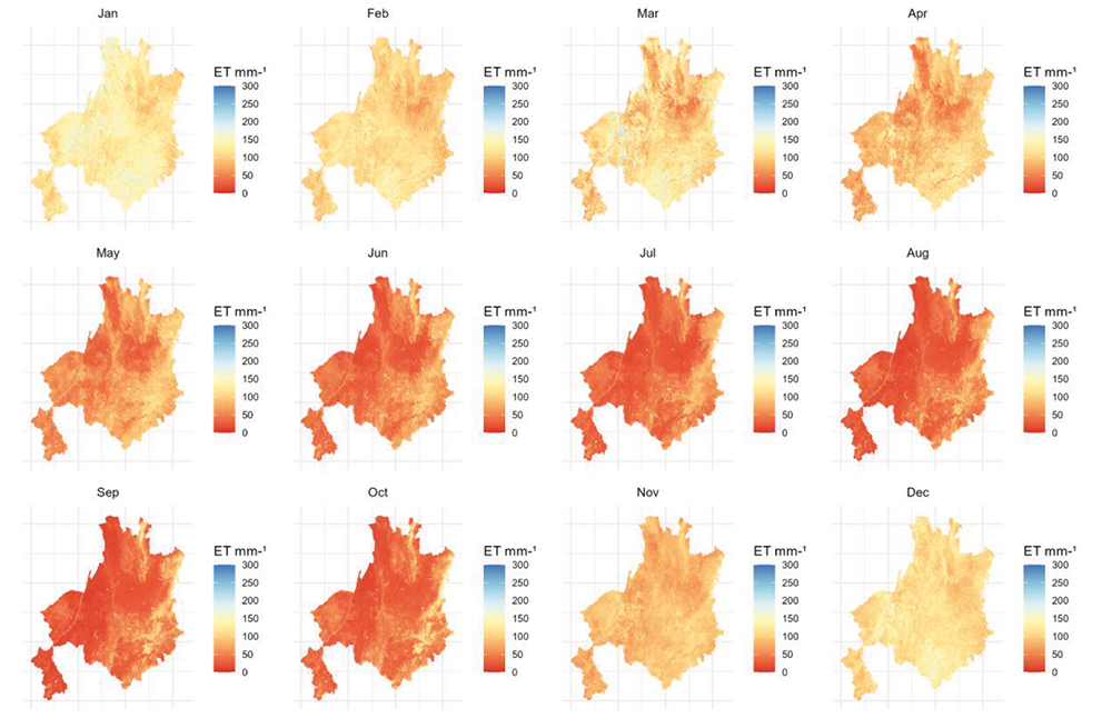
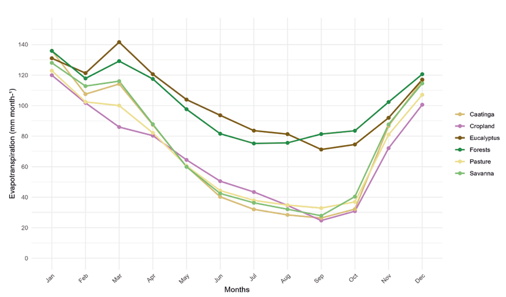
The monthly variations of ET for the year 2022 followed the typical dynamics of the climatic seasonality of the Brazilian semiarid zone, regardless of the LULC class (Figure 2). The highest average ET values (ranging from 89.63 mm month-¹ to 127.96 mm month-¹) occurred in the rainy season. In contrast, the lowest average ET rates (ranging from 37.01 mm month-¹ to 42.31 mm month-¹) were observed during the dry season. Notably, this shows the influence of water availability on the behavior of ET rates throughout the year.
ET rates also varied along the study region, although most of the region experienced low ET values, especially during the dry season (Figure 2). However, even with a substantial decline in ET during the dry season, the eastern portion of the region maintained relatively high values (100 mm month-¹ to 150 mm month-¹). This zone coincides with the distribution of natural forests (Atlantic rainforest) and eucalyptus plantations.
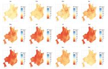
Spatial and temporal distribution of evapotranspiration (ET) for the study area. ET distributed over the 12 months of 2022
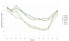
Eucalyptus plantations and forests exhibited the highest monthly evapotranspiration (ET) rates among the land use and land cover (LULC) classes, ranging from 81.33 mm month⁻¹ to 141.59 mm month⁻¹ and 75.21 mm month⁻¹ to 135.86 mm month⁻¹, respectively (Figure 3). This pattern persisted throughout most of the year, becoming particularly pronounced during the dry season compared to other land use types.
ET rates in croplands were slightly higher than those observed in Caatinga, savannas, and pastures during the dry season, likely due to the influence of irrigated agriculture, which sustains higher water fluxes in the BSR even during periods of low rainfall.
Caatinga, savannas, and pastures exhibited the highest seasonal variability in evapotranspiration (ET) throughout the year, particularly between the driest month (September) and the wettest month (January). Among these, the Caatinga showed the greatest ET amplitude (109.60 mm month⁻¹), followed by savannas (100.15 mm month⁻¹) and pastures (89.99 mm month⁻¹), reflecting their sensitivity to seasonal fluctuations in water availability.
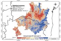
Spatial patterns of mean annual ET
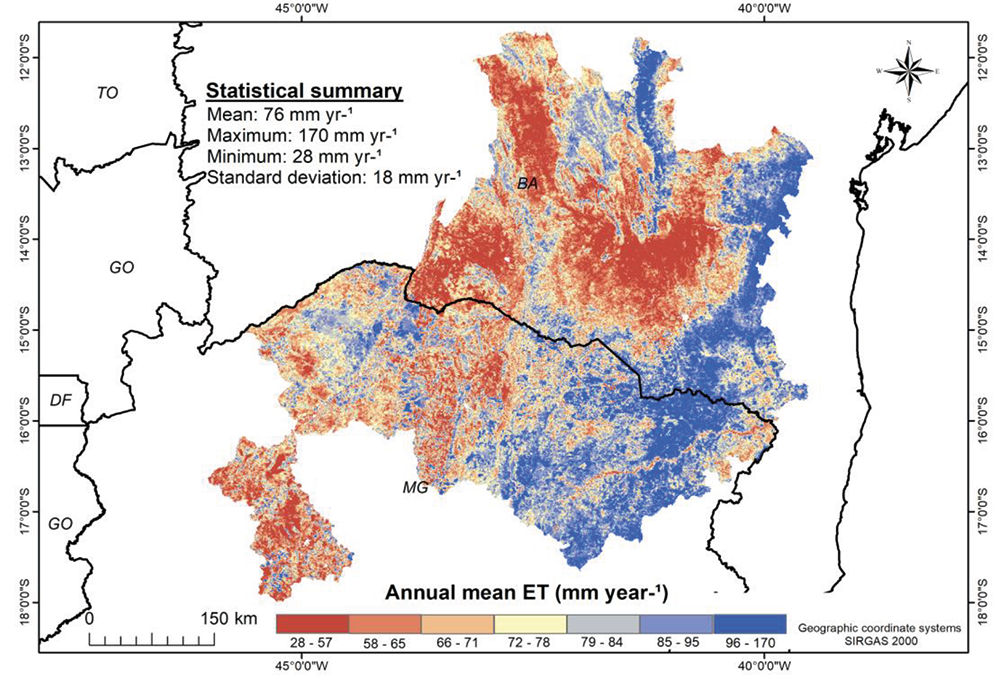
The distribution of the mean annual ET in the study region presented high spatial variation (Figure 4). The minimum ET values varied between 28 mm year-¹ and 57 mm year-¹ and occurred in 14.50% of the region, predominantly in the central-northern portion of the Caatinga biome, and in the west and southwest, where pastures and savannas are mostly found. On the other hand, the maximum values (96 mm year-¹ to 170 mm year-¹) were predominant in the eastern portion of the study region (~13%), coinciding with the occurrence of forests and eucalyptus plantations.
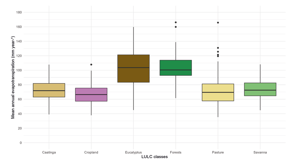
The ET rates of eucalyptus plantations showed significant differences (p-value < 0.05) concerning most land use and occupation classes (Figure 5 and Table 1). However, the water consumption of eucalyptus did not show significant differences (p-value > 0.05) in comparison to native forests of the Atlantic Forest.

Results of the Kruskal: Wallis test followed by the Dunn test comparing mean annual evapotranspiration among pairs of land use and land cover classes. The Z-score and p-value in bold correspond to the ET rates of land uses and land covers (LULC) with significant differences. A Z-score further from zero suggests a probability that the differences between the ET means are significant (p-value < 0.05)
DISCUSSION
Eucalyptus plantations showed higher water consumption through ET than other LULC classes in the BSR, a result that is consistent with findings in other parts of the world (Chanie et al., 2013; Mattos et al., 2019; Enku et al., 2020; Adorno et al., 2021; Peixoto Neto et al., 2022; Schume et al., 2022). These high ET rates for eucalyptus plantations are usually related to the physiological characteristics of this species, such as the rapid growth rates, the high density of trees in plantations, and the deep root system of individuals of this genus (Liu et al., 2017). Mostly important, the eucalyptus plantations maintain high ET rates even during the dry season, and this is possibly associated with its ability to extract water from deeper layers of the soil.
The high ET rates in croplands suggest the influence of irrigated agriculture, a practice that has been expanding in the BSR in recent decades (Franca Rocha et al., 2024). During the dry season, irrigation sustains elevated evapotranspiration levels, reflecting the continuous water supply to crops. Studies suggest that these conditions can induce an amplification in the decline of groundwater flows from river basins (Shi et al., 2012; Mattos et al., 2019).
No significant differences in ET rates were observed between eucalyptus plantations and natural forests. Previous studies have also shown that the water consumption of eucalyptus and native forests in the Atlantic Forest does not differ significantly (Almeida; Soares, 2003; Cristiano et al., 2015). This is certainly related to the availability of water in the soil of the Atlantic Forest. This biome, characterized by humid climates (Cwa and Cwb) with relatively lower temperatures (Alvares et al., 2013), supports higher soil moisture retention (Teixeira et al., 2023), which in turn sustains consistently high ET rates in the dry rainy seasons (Saiter et al., 2016).
Although ET rates in eucalyptus plantations and native forests are statistically similar, there are ecosystem differences between these two classes that should be considered. For example, forests provide critical hydrological services, such as regulating water flow within river basins, and serve as climatic refuges that support high levels of species endemism and vegetation diversity (Sales; Pires, 2023). These ecological functions, which are fundamental for maintaining regional biodiversity and water balance, are not performed by eucalyptus plantations.
Seasonal vegetation, such as Caatinga and Cerrado, exhibited significantly lower ET rates compared to eucalyptus plantations. This suggests that, in terms of potential reductions in water availability due to evapotranspiration, eucalyptus cultivation in these biomes poses a far greater hydrological impact than in native forests. The contrast in ET rates becomes even more pronounced during the dry season, as these ecosystems undergo significant leaf shedding in response to water scarcity (Medeiros et al., 2022). This adaptive strategy serves as a crucial mechanism to minimize water loss (Fu et al., 2024), effectively reducing ET during periods of drought (Silva et al., 2020).
Given the role of seasonal vegetation in maintaining regional water balance, strengthening public policies aimed at its conservation is essential. This includes expanding protected areas and ensuring the effective enforcement of existing environmental legislation, such as the Atlantic Forest Law No. 11.428/2006 (Brasil, 2006) and the Native Vegetation Protection Law Nos. 12.651/2012 and 12.727/2012 (Brasil, 2012). These measures are fundamental to preserving the ecological integrity of these biomes and mitigate the adverse effects of land-use changes on water resources.
ET rates in pastures were also lower than those observed in eucalyptus plantations, consistent with findings from previous studies (Silva et al., 2020). This pattern can be attributed to the structural characteristics of pasture vegetation. Unlike deep-rooted species, pastures are predominantly composed of a herbaceous stratum with a shallow root system, which limits access to deeper soil moisture and contributes to lower ET rates (Sampaio et al., 2007).
Additionally, pasture management practices play a crucial role in ET dynamics. According to the Brazilian Pasture Atlas, a significant portion of pastures in the Brazilian semiarid region exhibits a high degree of environmental degradation (LAPIG, 2022). This degradation accelerates biomass loss, further reducing ET rates (Andrade et al., 2014). These findings highlight the interplay between vegetation structure, land management, and hydrological processes, emphasizing the need for sustainable pasture management to mitigate environmental impacts in water-limited regions.
FINAL CONSIDERATIONS
This study assessed the evapotranspiration (ET) dynamics of eucalyptus plantations in comparison to other land use and land cover (LULC) classes in the Brazilian semi-arid region, using satellite-derived MOD16A2 data. The findings highlight the disproportionately high water consumption of eucalyptus, particularly during the dry season, a critical period of water scarcity in the region. This pattern raises concerns about its potential impact on local hydrological processes, including reduced groundwater recharge and increased pressure on water resources, which could exacerbate agrarian conflicts over water access.
The insights gained from this study have direct implications for land-use planning and water resource management in the semi-arid region. The results emphasize the urgent need for agro-environmental zoning strategies that consider water availability and ecosystem resilience. Specifically, relocating eucalyptus plantations away from water recharge areas and into less hydrologically sensitive landscapes could mitigate their adverse effects.
Furthermore, this study underscores the necessity of refining methodological approaches to enhance future research. Key improvements include: (i) extending the temporal scope of analysis beyond a single hydrological year, (ii) investigating competitive interactions between eucalyptus and other LULC classes regarding water use, and (iii) integrating ET estimates from MOD16A2 with high-resolution satellite sensors to refine spatial assessments. By addressing these aspects, future research can contribute to more sustainable land-use practices that balance economic productivity with environmental conservation in the Brazilian semi-arid region.
ACKNOWLEDGEMENTS
The authors thank the FAPEMIG and the Conselho Nacional de Desenvolvimento Científico e Tecnológico (CNPq).
DATA AVAILABILITY
The data that support the findings of this study can be made available, upon reasonable request, from the corresponding author [Marcos Esdras Leite].
REFERENCES
- AB’SÁBER, Aziz Nacib. Os domínios de natureza no Brasil: potencialidades paisagísticas. São Paulo: Ateliê Editorial, 2003. v. 1.
-
ADORNO, B. V., BARREIRA, S.; FERREIRA, M. E.; VELOSO, G. A. Influence of native and exotic tree plantations on biophysical indicators in the Brazilian Savanna. Pesquisa Agropecuária Tropical, v. 51, p. e65815, 2021. https://doi.org/10.1590/1983-40632021v5165815
» https://doi.org/10.1590/1983-40632021v5165815 -
ALLEN, R. G.; PEREIRA, L. S.; HOWELL, T. A.; JENSEN, M. E. Evapotranspiration information reporting: II. Recommended documentation. Agricultural Water Management, v. 98, n. 6, p. 921-929, 2011. https://doi.org/10.1016/j.agwat.2010.12.016
» https://doi.org/10.1016/j.agwat.2010.12.016 -
ALMEIDA, A. C.; SOARES, J. V. Comparação entre uso de água em plantações de Eucalyptus grandis e floresta ombrófila densa (Mata Atlântica) na costa leste do Brasil. Revista Árvore, v. 27, p. 159-170, 2003. https://doi.org/10.1590/S0100-67622003000200006
» https://doi.org/10.1590/S0100-67622003000200006 -
ALVARES, C. A.; STAPE, J. L.; SENTELHAS, P. C.; GONÇALVES, J. D. M.; SPAROVEK, G. Köppen's climate classification map for Brazil. Meteorologische Zeitschrift, v. 22, n. 6, p. 711-728, 2013. https://doi.org/10.1127/0941-2948/2013/0507
» https://doi.org/10.1127/0941-2948/2013/0507 -
ANDRADE, R. G.; TEIXEIRA, A. H. D. C.; SANO, E. E.; LEIVAS, J. F.; VICTORIA, D. C.; NOGUEIRA, S. F. Pasture evapotranspiration as indicators of degradation in the Brazilian Savanna: a case study for Alto Tocantins watershed. In: Remote Sensing for Agriculture, Ecosystems, and Hydrology XVI, 2014, [s.l.]. Anais [...]. SPIE, 2014. p. 508-514. https://doi.org/10.1117/12.2067225
» https://doi.org/10.1117/12.2067225 -
ANDRADE, B. C. C.; ANDRADE PINTO, E. J.; RUHOFF, A.; SENAY, G. B. Remote sensing-based actual evapotranspiration assessment in a data-scarce area of Brazil: a case study of the Urucuia Aquifer System. International Journal of Applied Earth Observation and Geoinformation, v. 98, p. 102298, 2021. https://doi.org/10.1016/j.jag.2021.102298
» https://doi.org/10.1016/j.jag.2021.102298 -
BARBOSA, H. A. Understanding the rapid increase in drought stress and its connections with climate desertification since the early 1990s over the Brazilian semi-arid region. Journal of Arid Environments, v. 222, p. 105142, 2024. https://doi.org/10.1016/j.jaridenv.2024.105142
» https://doi.org/10.1016/j.jaridenv.2024.105142 -
BHATTARAI, N.; WAGLE, P. Recent advances in remote sensing of evapotranspiration. Remote Sensing, v. 13, n. 21, p. 4260, 2021. https://doi.org/10.3390/rs13214260
» https://doi.org/10.3390/rs13214260 -
BRASIL. Lei da Mata Atlântica No. 11.428/2006. Available: https://www.planalto.gov.br/ccivil_03/_ato2004-2006/2006/lei/l11428.htm#:~:text=LEI%20N%C2%BA%2011.428%2C%20DE%2022%20DE%20DEZEMBRO%20DE%202006.&text=Disp%C3%B5e%20sobre%20a%20utiliza%C3%A7%C3%A3o%20e,Atl%C3%A2ntica%2C%20e%20d%C3%A1%20outras%20provid%C3%AAncias Accessed on: jun 19, 2025.
» https://www.planalto.gov.br/ccivil_03/_ato2004-2006/2006/lei/l11428.htm#:~:text=LEI%20N%C2%BA%2011.428%2C%20DE%2022%20DE%20DEZEMBRO%20DE%202006.&text=Disp%C3%B5e%20sobre%20a%20utiliza%C3%A7%C3%A3o%20e,Atl%C3%A2ntica%2C%20e%20d%C3%A1%20outras%20provid%C3%AAncias -
BRASIL. Lei de Proteção à Vegetação No. 12.727/2012. Available: https://www.planalto.gov.br/ccivil_03/_ato2011-2014/2012/lei/l12727.htm Acessed on: jun. 24, 2025.
» https://www.planalto.gov.br/ccivil_03/_ato2011-2014/2012/lei/l12727.htm -
CHANIE, T.; COLLICK, A. S.; ADGO, E.; LEHMANN, C. J.; STEENHUIS, T. S. Eco-hydrological impacts of Eucalyptus in the semi humid Ethiopian Highlands: the Lake Tana Plain. Journal of Hydrology and Hydromechanics, v. 61, n. 1, p. 21-29, 2013. https://doi.org/10.2478/johh-2013-0004
» https://doi.org/10.2478/johh-2013-0004 -
CHAO, L.; ZHANG, K.; WANG, J.; FENG, J.; ZHANG, M. A comprehensive evaluation of five evapotranspiration datasets based on ground and GRACE satellite observations: implications for improvement of evapotranspiration retrieval algorithm. Remote Sensing, v. 13, n. 12, p. 2414, 2021. https://doi.org/10.3390/rs13122414
» https://doi.org/10.3390/rs13122414 -
CRISTIANO, P. M.; CAMPANELLO, P. I., BUCCI, S. J.; RODRIGUEZ, S. A.; LEZCANO, O. A.; SCHOLZ, F. G.; GOLDSTEIN, G. Evapotranspiration of subtropical forests and tree plantations: a comparative analysis at different temporal and spatial scales. Agricultural and Forest Meteorology, v. 203, p. 96-106, 2015. https://doi.org/10.1016/j.agrformet.2015.01.007
» https://doi.org/10.1016/j.agrformet.2015.01.007 -
DUNN, O. J. Multiple comparisons using rank sums. Technometrics, v. 6, n. 3, p. 241-252, 1964. https://doi.org/10.1080/00401706.1964.10490181
» https://doi.org/10.1080/00401706.1964.10490181 -
ENKU, T.; MELESSE, A. M.; AYANA, E. K.; TILAHUN, S. A.; ABATE, M.; STEENHUIS, T. S. Groundwater use of a small Eucalyptus patch during the dry monsoon phase. Biologia, v. 75, n. 6, p. 853-864, 2020. https://doi.org/10.2478/s11756-020-00430-0
» https://doi.org/10.2478/s11756-020-00430-0 -
FERNANDES, M. F.; CARDOSO, D.; PENNINGTON, R. T.; QUEIROZ, L. P. The origins and historical assembly of the Brazilian Caatinga seasonally dry tropical forests. Frontiers in Ecology and Evolution, v. 10, 2022. https://doi.org/10.3389/fevo.2022.723286
» https://doi.org/10.3389/fevo.2022.723286 -
BARROS FERRAZ, S. F.; RODRIGUES, C. B.; GARCIA, L. G.; ALVARES, C. A.; PAULA LIMA, W. Effects of Eucalyptus plantations on streamflow in Brazil: moving beyond the water use debate. Forest Ecology and Management, v. 453, p. 117571, 2019. https://doi.org/10.1016/j.foreco.2019.117571
» https://doi.org/10.1016/j.foreco.2019.117571 -
FICK, S. E.; HIJMANS, R. J. WorldClim 2: new 1-km spatial resolution climate surfaces for global land areas. International Journal of Climatology, v. 37, p. 4302-4315, 2017. https://doi.org/10.1002/joc.5086
» https://doi.org/10.1002/joc.5086 -
FRANCA ROCHA, W. J.; VASCONCELOS, R. N.; COSTA, D. P.; DUVERGER, S. G.; LOBÃO, J. S.; SOUZA, D. T.; AGUIAR, W. M. Towards uncovering three decades of LULC in the Brazilian Drylands: Caatinga Biome Dynamics (1985-2019). Land, v. 13, n. 8, p. 1250, 2024. https://doi.org/10.3390/land13081250
» https://doi.org/10.3390/land13081250 -
FU, Z., CIAIS, P.; WIGNERON, J. P.; GENTINE, P.; FELDMAN, A. F.; MAKOWSKI, D.; SMITH, W. K. Global critical soil moisture thresholds of plant water stress. Nature Communications, v. 15, n. 1, p. 4826, 2024. https://doi.org/10.1038/s41467-024-49244-7
» https://doi.org/10.1038/s41467-024-49244-7 -
GRÜNZWEIG, J. M.; DE BOECK, H. J.; REY, A.; SANTOS, M. J.; ADAM, O.; BAHN, M.; YAKIR, D. Dryland mechanisms could widely control ecosystem functioning in a drier and warmer world. Nature Ecology & Evolution, p. 1-13, 2022. https://doi.org/10.1038/s41559-022-01779-y
» https://doi.org/10.1038/s41559-022-01779-y -
HUTLEY, L. B.; O'GRADY, A. P.; EAMUS, D. Evapotranspiration from Eucalypt open-forest savanna of Northern Australia. Functional Ecology, v. 14, n. 2, p. 183-194, 2000. https://doi.org/10.1046/j.1365-2435.2000.00416.x
» https://doi.org/10.1046/j.1365-2435.2000.00416.x -
IBGE - Instituto Brasileiro de Geografia e Estatística. Censo demográfico: 2010. Available: https://censo2010.ibge.gov.br/ Accessed on: nov. 26, 2023.
» https://censo2010.ibge.gov.br/ -
INMET - Instituto Nacional de Meteorologia. Catálogo de estações automáticas. Available: https://portal.inmet.gov.br/paginas/catalogoaut Accessed on: jun. 19, 2025.
» https://portal.inmet.gov.br/paginas/catalogoaut -
JARDIM, A. M. D. R. F.; ARAÚJO JÚNIOR, G. D. N.; SILVA, M. V. D.; SANTOS, A. D.; SILVA, J. L. B. D.; PANDORFI, H.; SILVA, T. G. F. D. Using remote sensing to quantify the joint effects of climate and land use/land cover changes on the Caatinga Biome of Northeast Brazilian. Remote Sensing, v. 14, n. 8, p. 1911, 2022. https://doi.org/10.3390/rs14081911
» https://doi.org/10.3390/rs14081911 -
KIM, H. W.; HWANG, K.; MU, Q.; LEE, S. O.; CHOI, M. Validation of MODIS 16 global terrestrial evapotranspiration products in various climates and land cover types in Asia. KSCE Journal of Civil Engineering, v. 16, n. 2, p. 229-238, 2012. https://doi.org/10.1007/s12205-012-0006-1
» https://doi.org/10.1007/s12205-012-0006-1 -
KRUSKAL, W. H.; WALLIS, W. A. Use of ranks in one-criterion variance analysis. Journal of the American Statistical Association, v. 47, n. 260, p. 583-621, 1952. https://doi.org/10.1080/01621459.1952.10483441
» https://doi.org/10.1080/01621459.1952.10483441 -
LAPIG - Laboratório de Processamento de Imagens e Geoprocessamento. Atlas das pastagens. 2022. Available: https://lapig.iesa.ufg.br/p/38972-atlas-das-pastagens Accessed on: nov. 27, 2024.
» https://lapig.iesa.ufg.br/p/38972-atlas-das-pastagens -
LEITE, M. E.; ALMEIDA, J. W. L.; SILVA, R. F. Análise espaço-temporal do eucalipto no Norte de Minas Gerais nos anos de 1986, 1996 e 2010. GeoTextos, 2012. https://doi.org/10.9771/1984-5537geo.v8i2.5931
» https://doi.org/10.9771/1984-5537geo.v8i2.5931 -
LI, G.; ZHANG, F.; JING, Y.; LIU, Y.; SUN, G. Response of evapotranspiration to changes in land use and land cover and climate in China during 2001-2013. Science of The Total Environment, v. 596-597, p. 256-265, 2017. https://doi.org/10.1016/j.scitotenv.2017.04.080
» https://doi.org/10.1016/j.scitotenv.2017.04.080 -
LI, X.; ZOU, L.; XIA, J.; DOU, M.; LI, H.; SONG, Z. Untangling the effects of climate change and land use/cover change on spatiotemporal variation of evapotranspiration over China. Journal of Hydrology, v. 612, p. 128189, 2022. https://doi.org/10.1016/j.jhydrol.2022.128189
» https://doi.org/10.1016/j.jhydrol.2022.128189 - LIMA, W. P. Comparative evapotranspiration of Eucalyptus, Pine and natural "Cerrado" vegetation measure by the soil water balance method. IPEF International, v. 1, p. 5-11, 1990.
-
LIU, W.; WU, J.; FAN, H.; DUAN, H.; LI, Q.; YUAN, Y.; ZHANG, H. Estimations of evapotranspiration in an age sequence of Eucalyptus plantations in subtropical China. PLOS ONE, v. 12, n. 4, p. e0174208, 2017. https://doi.org/10.1371/journal.pone.0174208
» https://doi.org/10.1371/journal.pone.0174208 -
MAPBIOMAS. Pontos de validação. 2023. Available: https://brasil.mapbiomas.org/pontos-de-validacao/ Accessed on: nov. 26, 2023.
» https://brasil.mapbiomas.org/pontos-de-validacao/ -
MARENGO, J. A.; TORRES, R. R.; ALVES, L. M. Drought in Northeast Brazil - past, present, and future. Theoretical and Applied Climatology, v. 129, n. 3, p. 1189-1200, 2017. https://doi.org/10.1007/s00704-016-1840-8
» https://doi.org/10.1007/s00704-016-1840-8 -
MATTOS, T. S.; OLIVEIRA, P. T. S. D.; LUCAS, M. C.; WENDLAND, E. Groundwater recharge decrease replacing pasture by Eucalyptus plantation. Water, v. 11, n. 6, p. 1213, 2019. https://doi.org/10.3390/w11061213
» https://doi.org/10.3390/w11061213 -
MEDEIROS, R.; ANDRADE, J.; RAMOS, D.; MOURA, M.; PÉREZ-MARIN, A. M.; SANTOS, C. A.; CUNHA, J. Remote sensing phenology of the Brazilian Caatinga and its environmental drivers. Remote Sensing, v. 14, n. 11, p. 2637, 2022. https://doi.org/10.3390/rs14112637
» https://doi.org/10.3390/rs14112637 -
MORO, M. F.; AMORIM, V. O.; DE QUEIROZ, L. P.; DA COSTA, L. R. F.; MAIA, R. P.; TAYLOR, N. P.; ZAPPI, D. C. Biogeographical districts of the Caatinga Dominion: a proposal based on geomorphology and endemism. The Botanical Review, 2024. https://doi.org/10.1007/s12229-024-09304-5
» https://doi.org/10.1007/s12229-024-09304-5 -
MU, Q.; ZHAO, M.; RUNNING, S. W. Improvements to a MODIS global terrestrial evapotranspiration algorithm. Remote Sensing of Environment, v. 115, n. 8, p. 1781-1800, 2011. https://doi.org/10.1016/j.rse.2011.02.019
» https://doi.org/10.1016/j.rse.2011.02.019 -
NETO, S. P. G. C. Três décadas de Eucalipto no extremo Sul da Bahia. GEOUSP: Espaço e Tempo (Online), v. 16, n. 2, p. 55-68, 2012. https://doi.org/10.11606/issn.2179-0892.geousp.2012.74252
» https://doi.org/10.11606/issn.2179-0892.geousp.2012.74252 -
OGLE, D. H.; DOLL, J. C.; WHEELER, A. P. DINNO, A. FSA: Simple fisheries stock assessment methods. version 0.9.5, 2023. Available: https://cran.r-project.org/web/packages/FSA/index.html Accessed on: nov. 19, 2024.
» https://cran.r-project.org/web/packages/FSA/index.html -
PAULA SOUSA JÚNIOR, V.; SPARACINO, J.; ESPINDOLA, G. M.; SOUSA DE ASSIS, R. J. Land-use and land-cover dynamics in the Brazilian Caatinga dry tropical forest. Conservation, v. 2, n. 4, p. 739-752, 2022. https://doi.org/10.3390/conservation2040048
» https://doi.org/10.3390/conservation2040048 -
PEIXOTO NETO, A. M.; CARTWRIGHT, I.; SILVA, M. R.; MCHUGH, I.; DRESEL, P. E.; TEODOSIO, B.; DALY, E. Linking evapotranspiration seasonal cycles to the water balance of headwater catchments with contrasting land uses. Hydrological Processes, v. 36, n. 12, p. e14784, 2022. https://doi.org/10.1002/hyp.14784
» https://doi.org/10.1002/hyp.14784 -
PENNINGTON, R. T.; LEHMANN, C. E. R.; ROWLAND, L. M. Tropical savannas and dry forests. Current Biology, v. 28, n. 9, p. R541-R545, 2018. https://doi.org/10.1016/j.cub.2018.03.014
» https://doi.org/10.1016/j.cub.2018.03.014 -
QGIS. Spatial without Compromise QGIS Web Site. 2024. Available: https://www.qgis.org/ Accessed on: aug. 20, 2024.
» https://www.qgis.org/ - RIBEIRO, J. F.; WALTER, B. M. Teles. Fitofisionomias do bioma cerrado. In: SANO, S. M.; ALMEIDA, S. P. (ed.). Cerrado: ecologia e flora. Planaltina: Embrapa Cerrados, 2008. p. 152-212.
-
PEIXOTO NETO, A. M.; CARTWRIGHT, I.; SILVA, M. R.; MCHUGH, I.; DRESEL, P. E.; TEODOSIO, B. Daly Assessment of the MODIS global evapotranspiration algorithm using eddy covariance measurements and hydrological modelling in the Rio Grande basin. Hydrological Sciences Journal, v. 58, n. 8, p. 1658-1676, 2013. https://doi.org/10.1080/02626667.2013.837578
» https://doi.org/10.1080/02626667.2013.837578 -
RUNNING, S.; MU, Q.; ZHAO, M. MOD16A2 MODIS/Terra net evapotranspiration 8-day L4 global 500m SIN Grid v006. NASA EOSDIS Land Processes DAAC, v. 6, 2017. https://doi.org/10.5067/MODIS/MOD16A2.006
» https://doi.org/10.5067/MODIS/MOD16A2.006 -
SAITER, F. Z.; EISENLOHR, P. V.; BARBOSA, M. R.; THOMAS, W. W.; OLIVEIRA-FILHO, A. T. From evergreen to deciduous tropical forests: how energy-water balance, temperature, and space influence the tree species composition in a high diversity region. Plant Ecology & Diversity, v. 9, n. 1, p. 45-54, 2016. https://doi.org/10.1080/17550874.2015.1075623
» https://doi.org/10.1080/17550874.2015.1075623 -
SALES, L. P.; PIRES, M. M. Identifying climate change refugia for South American biodiversity. Conservation Biology, v. 37, n. 4, p. e14087, 2023. https://doi.org/10.1111/cobi.14087
» https://doi.org/10.1111/cobi.14087 -
SAMPAIO, G.; NOBRE, C.; COSTA, M. H.; SATYAMURTY, P.; SOARES‐FILHO, B. S.; CARDOSO, M. Regional climate change over eastern Amazonia caused by pasture and soybean cropland expansion. Geophysical Research Letters, v. 34, n. 17, 2007. https://doi.org/10.1029/2007GL030612
» https://doi.org/10.1029/2007GL030612 -
SANTOS, W. R.; JARDIM, A. M. D. R. F.; DE SOUZA, L. S. B.; DE SOUZA, C. A. A.; MORAIS, J. E. F.; ALVES, C. P.; SILVA, T. G. F. Can changes in land use in a semi-arid region of Brazil cause seasonal variation in energy partitioning and evapotranspiration? Journal of Environmental Management, v. 367, p. 121959, 2024. https://doi.org/10.1016/j.jenvman.2024.121959
» https://doi.org/10.1016/j.jenvman.2024.121959 -
SCHUME, H.; HAILU, Z.; HAILU, T.; SIEGHARDT, M.; GODBOLD, D. L. Spatial analysis of soil water depletion and biomass production in the transition zone between a Eucalyptus camaldulensis stand and a maize field in Ethiopia. Agricultural and Forest Meteorology, v. 320, p. 108956, 2022. https://doi.org/10.1016/j.agrformet.2022.108956
» https://doi.org/10.1016/j.agrformet.2022.108956 - SHI, Z.; XU, D.; YANG, X.; JIA, Z.; GUO, H.; ZHANG, N. Ecohydrological impacts of Eucalypt plantations: a review. Journal of Food, Agriculture and Environment, v. 10, p. 1419-1426, 2012.
-
SILVA, B. B.; WILCOX, B. P.; SILVA, V. D. P. R.; MONTENEGRO, S. M. G. L.; OLIVEIRA, L. M. M. Changes to the energy budget and evapotranspiration following conversion of tropical savannas to agricultural lands in São Paulo State, Brazil. Ecohydrology, v. 8, n. 7, p. 1272-1283, 2015. https://doi.org/10.1002/eco.1580
» https://doi.org/10.1002/eco.1580 -
SILVA, L. A.; DE SOUZA, C. M. P.; LEITE, M. E.; FILGUEIRAS, R. Estimativa da perda de água na APA do Rio Pandeiros, Minas Gerais. Caderno de Geografia, v. 30, n. 62, p. 768, 2020. https://doi.org/10.5752/P.2318-2962.2020v30n62p768
» https://doi.org/10.5752/P.2318-2962.2020v30n62p768 -
SOUZA JR, C. M.; Z. SHIMBO, J.; ROSA, M. R.; PARENTE, L. L.; A. ALENCAR, A.; RUDORFF, B. F.; AZEVEDO, T. Reconstructing three decades of land use and land cover changes in Brazilian biomes with Landsat archive and Earth Engine. Remote Sensing, v. 12, n. 17, p. 2735, 2020. https://doi.org/10.3390/rs12172735
» https://doi.org/10.3390/rs12172735 -
TEIXEIRA, A.; LEIVAS, J.; TAKEMURA, C.; BAYMA, G.; GARÇON, E.; SOUSA, I.; SILVA, C. Remote sensing environmental indicators for monitoring spatial and temporal dynamics of weather and vegetation conditions: applications for Brazilian biomes. Environmental Monitoring and Assessment, v. 195, n. 8, p. 944, 2023. https://doi.org/10.1007/s10661-023-11560-8
» https://doi.org/10.1007/s10661-023-11560-8 -
VAN ZYL, J. J. The Shuttle Radar Topography Mission (SRTM): a breakthrough in remote sensing of topography. Acta Astronautica, v. 48, p. 559-565, 2001. https://doi.org/10.1016/S0094-5765(01)00020-0
» https://doi.org/10.1016/S0094-5765(01)00020-0 -
WANG, Q.; CHENG, L.; ZHANG, L.; LIU, P.; QIN, S.; LIU, L.; JING, Z. Quantifying the impacts of land-cover changes on global evapotranspiration based on the continuous remote sensing observations during 1982-2016. Journal of Hydrology, v. 598, p. 126231, 2021. https://doi.org/10.1016/j.jhydrol.2021.126231
» https://doi.org/10.1016/j.jhydrol.2021.126231 -
YANG, Z.; ZHANG, Q.; HAO, X.; YUE, P. Changes in evapotranspiration over global semiarid regions 1984-2013. Journal of Geophysical Research: Atmospheres, v. 124, n. 6, p. 2946-2963, 2019. https://doi.org/10.1029/2018JD029533
» https://doi.org/10.1029/2018JD029533 -
ZHANG, Y.; PEÑA-ARANCIBIA, J. L.; MCVICAR, T. R.; CHIEW, F. H.; VAZE, J.; LIU, C.; PAN, M. Multi-decadal trends in global terrestrial evapotranspiration and its components. Scientific Reports, v. 6, n. 1, p. 19124, 2016. https://doi.org/10.1038/srep19124
» https://doi.org/10.1038/srep19124 -
ZHANG, K; KIMBALL, J. S.; RUNNING, S. W. A review of remote sensing-based actual evapotranspiration estimation. WIREs Water, v. 3, n. 6, p. 834-853, 2016. https://doi.org/10.1002/wat2.1168
» https://doi.org/10.1002/wat2.1168
-
ASSOCIATE EDITOR
Silvio Carlos Rodrigues - 0000-0002-5376-1773

 Source: The authors (2025).
 Source: The authors (2025). Cartographic convention: Geographic coordinate systems - SIRGAS 2000.
 Source: The authors (2025).
 Source: The authors (2025).
 Source: The authors (2025).