
 Healthy and sustainable rural territory index: a proposal for health, environmental and labor surveillance
Abstract
Introduction Development surveillance is a political and social approach that integrates participatory actions within the Unified Health System (SUS) and public policies.
Objective To present the Municipal Index of Healthy and Sustainable Rural Territories (I-TSSR) to monitor the harmful influence of agribusiness on the environment, work and its repercussions on health in the state of Mato Grosso (MT).
Methods Ecological study based on secondary data from social, environmental, health and occupational indicators. A composite index was calculated from the indicators calculated and spatially distributed in the municipalities for the period 1990 to 2022.
Results The value of the I-TSSR ranged from 3 to 25. The spatial distribution in the territory allows us to find out 34 municipalities with greater impacts of environmental degradation and the occurrence of negative health outcomes, such as pesticide poisoning, accidents at work, congenital malformations and childhood cancer (I-TSSR: 17.47-25.00), located in the West, Mid-North, Northeast and South of Mato Grosso regions.
Conclusion Development surveillance, through the I-TSSR, offers an innovative approach to understanding the impacts of agribusiness. By integrating health, environmental and social development information, this approach promotes a broad and participatory view of the health and sustainable development situation.
Worker Health; Sustainable Development Indicators; Health Surveillance; Environmental Health; Ecological Studies
Resumo
Introdução A vigilância do desenvolvimento configura-se como abordagem política e social que integra ações participativas no âmbito do Sistema Único de Saúde (SUS) e das políticas públicas.
Objetivo Apresentar o Índice Municipal de Território Saudável e Sustentável Rural (I-TSSR) para monitorar a influência deletéria do agronegócio no ambiente, no trabalho e suas repercussões na saúde, no estado de Mato Grosso (MT).
Métodos Estudo ecológico com base em dados secundários de indicadores sociais, ambientais, sanitários e ocupacionais. Foi calculado um índice composto, a partir dos indicadores calculados e distribuídos espacialmente nos municípios, para o período de 1990 a 2022.
Resultados O valor do I-TSSR variou de 3 a 25. A distribuição espacial no território permitiu identificar 34 municípios com maiores impactos de degradação ambiental e ocorrência de desfechos negativos em saúde, como intoxicações por agrotóxicos, acidentes de trabalho, malformações congênitas e câncer infantojuvenil (I-TSSR: 17,47-25,00), localizados nas regiões: Oeste, Médio Norte, Nordeste e Sul-mato-grossense.
Conclusão A vigilância do desenvolvimento, através do I-TSSR, oferece uma abordagem inovadora para compreender os impactos do agronegócio. Ao integrar informações de saúde, ambiente e desenvolvimento social, esta abordagem promove uma visão ampla e participativa da situação de saúde e desenvolvimento sustentável.
Saúde do Trabalhador; Indicadores de Desenvolvimento Sustentável; Vigilância em Saúde; Saúde Ambiental; Estudos Ecológicos
Introduction
Development surveillance studies how the different ways of using territories are configured and operate from the political-social, intersectoral, and hegemonic apparatus, interfering in local decisions that have an impact on health, the environment, and work. This approach brings up the need for participatory action within the Unified Health System (SUS) and public policies, and the debate on the process of territorialization of institutional and popular actions, based on the transformation of economic and social bases and the accumulation model of agribusiness production chains. In a dialogue mobilized by the organization of information coming from the territory, from an emancipatory perspective1,2, a transition from development surveillance is made possible by materializing the non-delegation of health, pointed out by Oddone3, by involving a popular dynamic in the information action to define practices and cultural expressions that protect a healthy and plural life.
In its essence of information for action, health surveillance leads us to strategies and activities guided by conceptual models for structuring information, for local/territorial interaction and governance. This set of strategies includes the development of indicators and tools to support processes for sharing and circulating information4.
By following these assumptions, the aim is to present and problematize indicators that integrate society, the environment, health, and work, in an instrument for evaluating municipal and regional trends for health surveillance action that expresses information and names the dynamics of social and environmental processes and health impacts. The indicators make it possible to analyze and reflect on the prospects for a healthy way of life from the perspective of cultural realization, producing movements to collectively bring information closer to a preventive ecosystem understanding. It is articulated as a materiality of the essence of a governance model that drives actions beyond the health sector, but above all, an expression based on the modes of living of populations and the demands of social and popular movements.
Thus, the aim of this article is to present a health, environment, and work surveillance index and the organization of a method for integrating social, environmental, health, and occupational indicators, on a municipal scale, which identify pressure from the mode of development in regions with hegemonic agribusiness, in order to contribute to actions of mobilization and social participation in the definition of public policies to promote healthy and sustainable territories, resizing development from a perspective of good living.
Methods
Study design and context
This is an ecological study. The study site is the state of Mato Grosso, which is in the Central-West region of Brazil. According to the latest census, from 2022, its population is estimated at 3,658,813 people, with a population density of 4.05 h/km2, a Human Development Index (2021) of 0.736 and a territorial extension of 903,208.361 km2, however, only 1,244.20 km2 (0.13%) of its area is urbanized, which favors the large estates for planting agricultural commodities5.
Data sources
Data on records of acute pesticide poisoning and suicide attempts were obtained from the Notifiable Diseases Information System (Sinan)6. Data on deaths from external causes (accidents at work and homicides) were obtained from the Mortality Information System (SIM). Cases of congenital malformations, as well as birth records, were obtained from the Live Births Information System (Sinasc)7. Data on cancer cases among children and adolescents living in the state of Mato Grosso was obtained from the population-based cancer registry (RCBP)8of the National Cancer Institute (INCA), according to data provided by the State Health Department of the state of Mato Grosso.
The data used to calculate the environmental indicators was obtained from the MapBiomas geographic data platform9-11. For the socio-environmental indicators, the sources were the IBGE - Brazilian Institute of Geography and Statistics -, Automatic Recovery System (Sidra) and the Agricultural Defense Institute of the State of Mato Grosso (INDEA/MT).
Calculated indicators
The following health and occupational indicators were calculated:
-
incidence rate of attempted suicide (number of cases per municipality of residence/population of the municipality x 100,000 inhabitants), in 2020;
-
incidence rate of accidents at work (number of accidents/general population x 100,000 inhabitants),in 2020;
-
homicide mortality rate (number of homicide deaths by municipality of residence/general population x 100,000) in 2020;
-
external cause mortality rate (number of deaths per municipality of residence/general population x 100,000) in 2020;
-
patterned incidence rate of childhood cancer (number of cancer cases - 0 to 19 years/population of children and adolescents x 1 million), between 2013 and 2018; and
-
prevalence of congenital malformations (number of cases of congenital malformations per municipality of residence/live births x 1,000) in 2020.
The environmental indicators were calculated by averaging the values recorded for areas of deforestation, fires, and water surface reduction in the years studied. The annual average of hectares burnt and deforested was calculated, as well as the loss of water surface between 1990 and 2020, which were grouped together to form a single composite environmental indicator. By adding up the four geometric classes each of the three indicators (deforestation, burning and water surface reduction), the total number of environmental impact intensities was obtained for each of the 141 municipalities in Mato Grosso.
The socio-environmental indicators were:
-
the percentage allocated to family farming in each municipality of Mato Grosso, calculated by comparing the areas of family and non-family farming in the state, as provided by the Agricultural Census (IBGE-Sidra)12;
-
the size of the soybean planting area in Mato Grosso, available from the Municipal Agricultural Production database (IBGE/Sidra)13; and
-
mass per kilogram of pesticides, available from INDEA-MT14.
Data analysis
The calculation of the three components, social, environmental, and health, was distributed according to the magnitude of land use patterns and their impacts. Three blocks of indicators were proposed, the first of which was abstract and the other two concrete: 1. Abstract Institutional/Socio-environmental Exposure, with information on public land use policies, food production, and the intensity of pesticide use; 2. Environmental Impacts, with information on the reduction of biodiversity and contribution to water scarcity; and 3. Health Impacts/Socio-environmental Mediation, on which the Health Situation Inequality Scenarios are based.
These components presuppose the collection, storage, processing, and availability of secondary data on processes, determinants, and impacts on health and sustainability related to the territory, reaffirming the dynamics of the territory, in a permanent process of change, as a place of contradictions, a place of work, resistance, material and spiritual exchanges in everyday life15.
With this in mind, to produce information for action and surveillance of development in agribusiness territories, a basic instrument was proposed for popular and participatory monitoring and surveillance of health, interconnected with work and the environment. The Municipal Index of Healthy and Sustainable Rural Territories (I-TSSR) was calculated as the sum of the aforementioned blocks of indicators.
All the indicators calculated were divided into four categories, following the same classification pattern, according to the gradient of the magnitude of the indicators or impact: low (0), medium-low (1), medium-high (2), and high (3). Esri’s ArcGis 10.1 application was used to calculate the geometric intervals of the socio-environmental and health indicators, as well as to draw up the thematic maps.
Ethical considerations
This ecological study used secondary data obtained from publicly available databases, except for data on the incidence of childhood cancer, provided by the Mato Grosso State Health Department. The analysis of these data was one of the integral parts of the research projects entitled “Fatores associados ao Câncer infanto-juvenil: Análise de Registro Hospitalar e Populacional de Mato Grosso” (Factors associated with Childhood Cancer: Analysis of Hospital and Population Registry in Mato Grosso), approved through CAAE No. 42264420.6.0000.8124 on May 18, 2021, and “Promoção de Territórios Saudáveis e Sustentáveis no Mato Grosso” (Promotion of Healthy and Sustainable Territories in Mato Grosso), through CAAE No. 35803020.0.0000.8124, on December 15, 2020. Both projects were submitted to and approved by the respective research ethics committees of the Federal University of Mato Grosso and funded with resources from of the Mato Grosso Public Labor Prosecutor’s Office - Regional Labor Prosecutor’s Office of the 23rd Region.
Results
The I-TSSR value ranged from 3 to 25. The cumulative indicators (socio-environmental, environmental and health/occupational), according to exposure gradients and units of measurement, can be seen in Table 1.
Figure 1 shows the distribution of I-TSSR in the municipalities of MT. The 34 municipalities where the I-TSSR was highest (values between 17.47 and 25.00) can be seen in the darker areas of the map, mainly in the regions: West, Middle North, Northeast and South Mato Grosso. In 40 municipalities, concentrated in the northern region of the state, lower values were observed, 3 and 10.54%.

Municipal Index of Healthy and Sustainable Rural Territories (I-TSSR), in the municipalities of the state of Mato Grosso, Brazil
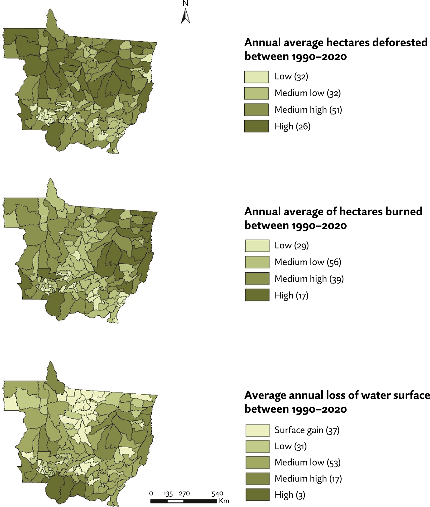
In the period from 1990 to 2020, the state of Mato Grosso deforested 19,998,972 hectares, which represented 21.43% of the entire area deforested in Brazil in the period. The data is also alarming when considering the indicators for the occurrence of fires in the country, given that the state was responsible for the burning of 121,924,553 hectares, which corresponds to approximately 24.42% of the entire national territory. Regarding the reduction of water resources, 631,444 hectares of its water surface were lost, which corresponds to the subtraction of 50.72% of its total area.
Figure 2 shows the respective influence and contribution of each municipality in Mato Grosso to deforestation, burning and water surface loss over the three-decade period. It can be noted that deforestation is mainly concentrated among those municipalities located in the north of the state, in areas of dense forest belonging to the Amazon biome. Considering the average annual deforestation among the 141 municipalities in Mato Grosso, the ones with the most deforestation were: Juara (18,864.9 ha), Brasnorte (15,628.19 ha), Nova Ubiratã (15,375.84 ha), Colniza (14.518.77 ha), Querência (13,868.55 ha), Villa Bela de Santíssima Trindade (13,614.68 ha), Gaúcha do Norte (13,425.03 ha), Paranatinga (13,187.26 ha), Sorriso (12,268.13 ha), and Cáceres (11,918.77 ha).
Average annual number of hectares burned, deforested, and loss of water surface in the municipalities of the state of Mato Grosso, Brazil, 1990-2020
The pattern of fires involves a distribution similar to that observed in the areas of major deforestation in Mato Grosso, however, it differs in that it is more concentrated in the municipalities located in the northeast of the state, heading towards the border areas with the states of Pará and Tocantins. The municipalities with the largest areas of deforestation were: Cocalinho (196,591.1 ha), Ribeirão Cascalheira (166,955.32 ha), São Félix do Araguaia (166,332.03 ha), Tangará da Serra (163.715.06 ha), Paranatinga (148,150.1 ha), Luciara (122,463.45 ha), Gaúcha do Norte (113,337.45 ha), Novo Santo Antônio (101,184.26 ha), Campinápolis (96,705.16 ha), and Vila Bela da Santíssima Trindade (87,650.94 ha).
Regarding the reduction in water surface area, the municipalities located in the Pantanal region of Mato Grosso suffered severe water loss when compared to the other areas of the state. Of particular note are the municipalities of Cáceres (307,369 ha) and Poconé (183,718 ha), which together were responsible for the loss of 491,087 hectares, corresponding to 77.77% of all water surface suppression in the state. The reduction in water surface was still high in the municipalities of: Barão de Melgaço (28,016 ha), Vila Bela da Santíssima Trindade (19,994 ha), Gaúcha do Norte (17,309 ha), Cocalinho (15,364 ha), and Querência (14,060 ha).
Regarding the area set aside for soybean planting in the municipalities of Mato Grosso, the regions that stand out most in terms of productivity are those located between the north-central and northwestern portions of the state (Figure 3). Among the 141 municipalities in the state of Mato Grosso, those that allocated the most land to soybean cultivation in 2022 were: Sorriso (598,500 ha), Nova Mutum (397,000 ha), Diamantino (389,940 ha), Campo Novo do Parecis (387,800 ha), Sapezal (385,614 ha), and Querência (375,000 ha).

Area destined for family farming in 2017, area in hectares (ha) destined for soybean planting in 2022 and mass (kg) of the active ingredients of pesticides used in the municipalities of the state of Mato Grosso, Brazil
The municipalities that used the most pesticides in Mato Grosso in 2022 were: Sorriso (8,552,669 kg), Sapezal (7,191,637 kg), Campo Novo do Parecis (6,297,607 kg), Diamantino (4,464,078 kg), Lucas do Rio Verde (4,406,738 kg), Nova Ubiratã (4,134,546 kg), and Campo Verde (3,798,389 kg).
This concentrated land configuration seems to be located mainly in municipalities linked to significant production of agricultural commodities. The lowest percentages of family farming in Mato Grosso were observed in the municipalities of: Campos de Júlio (0.32%), Santo Antônio do Leverger (0.50%), Primavera do Leste (0.54%), Campo Novo do Parecis (0.56%), Cocalinho (0.60%), and Santa Rita do Trivelato (0.67%).
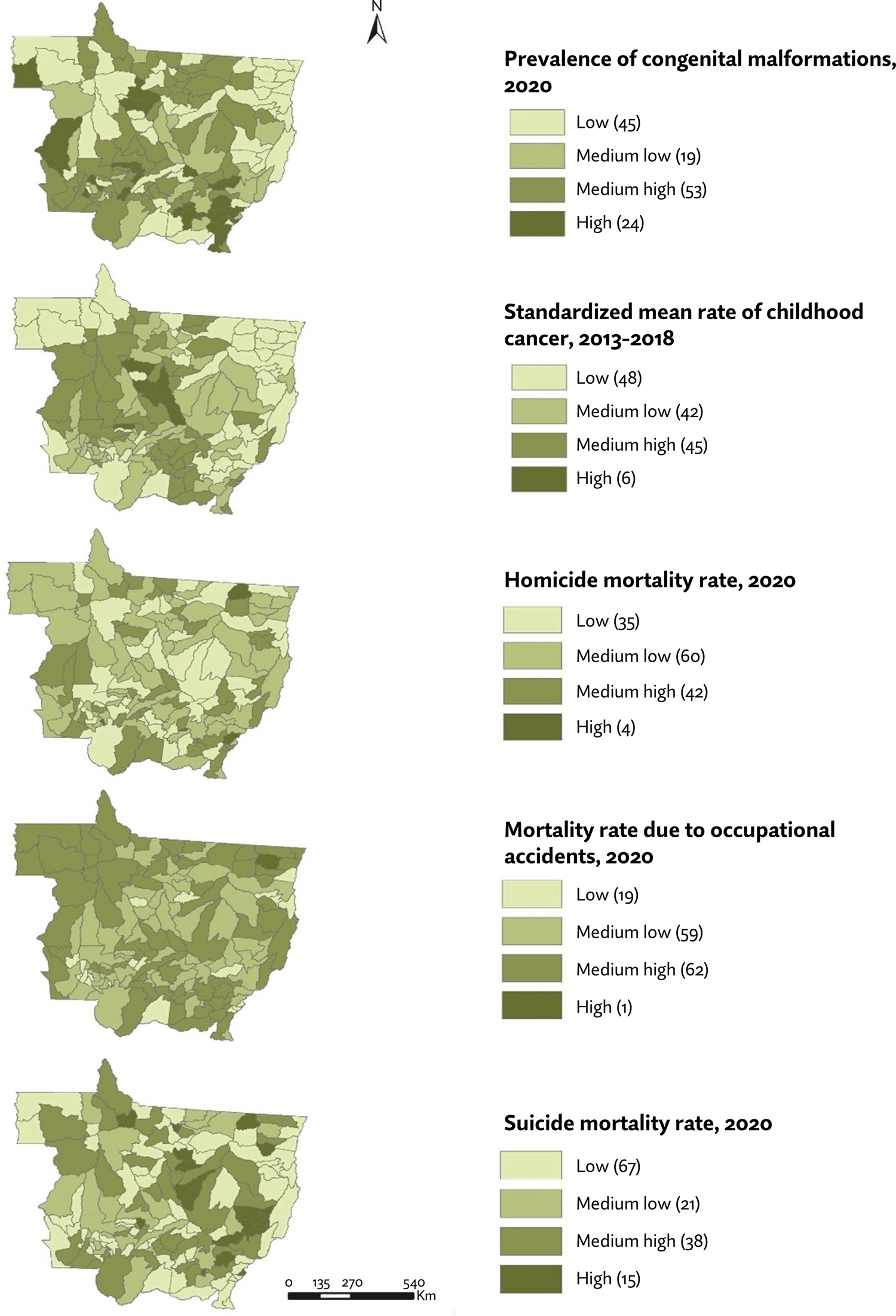
In the health/occupational component, the prevalence of congenital malformations in most municipalities (53%) is classified as medium-high impact, with a variation between 5.48 and 10.08 cases per 1,000 live births. The highest prevalence rates are found in the southern part of Mato Grosso, in the municipalities of São José do Povo (34.78 per thousand), São Pedro da Cipa (32.14 per thousand), and Tabaporã (22.73 per thousand)
Regarding child and adolescent cancer incidence rates, almost half (48%) of the municipalities have between 37 and 145.55/1 million children and adolescents. The municipalities with the highest rates are in the mid-north of the state: Nova Marilândia (612/1 million), Tapurah (369/1 million), and Santa Rita do Trivelato (349/1 million).
Homicide mortality rates predominated in the medium-low category, ranging from 8.92 to 63.86 deaths per 100,000 inhabitants. In terms of spatial distribution, there was relative homogeneity across Mato Grosso, with the highest rates in the capital and in border municipalities, including Curvelândia (2678.67/100,000), Santa Cruz do Xingu (2488.30/100,000), and Torixoréu (1989.47/100,000).
In most municipalities, mortality rates from accidents at work fall into the medium-high category, ranging from 343.13 to 9,869.26 per 100,000 inhabitants. These municipalities are located long distances from the state capital, Cuiabá. However, they are mainly located in border regions with other countries such as Bolivia and with other states in the northern region, such as Rondônia, Amazonas, and Pará. This can be seen in the municipality of Confresa, where the rate found was (283,553/100,000).
Suicide mortality rates were predominantly low in the municipalities of Mato Grosso, ranging from 0 to 1.59. This finding can be explained by the underreporting of cases on death certificates. The highest rate was 60 deaths per 100,000 inhabitants in the municipality of Novo São Joaquim.
Other rates can be seen in Figure 4 and Table 1.

Health and labor indicators in the municipalities of the state of Mato Grosso, Brazil, 2013-2022
Discussion
The territory of Mato Grosso is an exponent of an asymmetrical socio-economic development paradigm, which obeys the monopoly corporations of agribusiness, accumulating wealth, generating inequalities, and socializing diseases, expanding environmental and social impacts. We are dealing here with a hegemonic model that generates sickening modes of living, involved in the (re)production of health inequalities, causing environmental contamination16-19, human health problems such as pesticide poisoning20, accidents at work21, the social and mental suffering of rural workers22,23, suicide among agribusiness workers24, fetal malformations25, respiratory diseases in children under five26, cancers related to environmental and occupational exposure27, as well as food contamination and the consequences for food sovereignty and security in the territories28.
A series of socio-technical transformations have been responsible for the transition and modernization of Mato Grosso’s agricultural landscape, leading to the transition from a locally based production model to a new production model that is subordinate to the needs of international capital29. Chemical apparatuses, mechanization, development policies, and the precariousness of environmental monitoring and labor laws have been responsible for profound transformations in production methods around the world30, increasing efficiency and yields, while at the same time producing immeasurable consequences for human health, the environment and local socio-cultural modes of living.
These social and economic transformations, as well as the historical unequal distribution and concentration of arable land in Brazil and Mato Grosso, have resulted in a low presence of family farming in the municipalities surveyed, in addition to the invisibility of indigenous and quilombola farming. The highest proportion of land allocated to family farming among the municipalities in Mato Grosso was just over 5%. This information shows that Brazilian family farming continues to be marked by socio-spatial inequality, unequal income distribution, the absence or insufficiency of public policies to promote production and marketing, which leads to land abandonment, violent land disputes, and threats reproduced by large landowners, soil and water contamination, generating environmental injustices31.
Mato Grosso is home to the Cerrado, Amazon, and Pantanal biomes, with important biodiversity and river springs that form and supply the Amazon, Paraguay, and Tocantins-Araguaia river basins, making a significant contribution to the replenishment and availability of water in Latin America32. However, the agribusiness economic development project has interpreted nature as a source of inexhaustible resources, and Mato Grosso, as an influential exponent of this hegemonic model, has participated intensely in this socio-environmental exploitation. Over the last three decades (1990-2020), the state has not only consolidated its position as Brazil’s largest agricultural producer but has also become the epicenter of a process of intense environmental degradation that has influenced the territory’s ecosystemic imbalance. In this study, this process can be demonstrated through the high occurrence and scope of deforestation, fires, and loss of water surface in the state33.
In addition, the regions of Mato Grosso with the highest TSS-Rural rates, which deserve attention due to the accumulation of environmental degradation (deforestation and fires), the intense use of chemical products, and health problems such as childhood cancer, are territories with large agribusiness production. This can be explained, for example, by the intrinsic relationship observed throughout Brazil between the advance of the agricultural frontier and livestock farming and the deforestation and burning of native vegetation33,34.
The chemical-dependent production model of Brazilian agribusiness is based on the use of chemical inputs such as pesticides and fertilizers to grow agricultural commodities and raise cattle. This model uses more than 899 million liters of agrochemicals every year, with Mato Grosso being the state in first place in this ranking, making it the national breadbasket of Brazilian agribusiness35.
In this context, the TSS-Rural index is presented as an information tool for health surveillance action that aggregates data from different sources, expressing the dynamics of social and environmental processes and health impacts, and enables analysis and reflection on the prospects for a healthy way of life, as well as movements towards a model of collective governance that drives actions beyond the health sector, integrating other sectors, but mainly based on the modes of living of populations and the demands of social and popular movements2. Thus, the TSS-Rural index, in the hypothesis of its intersectoral use as an instrument of participatory governance in the SUS, is articulated with the notion of vigilance of development as a possibility for the critical transformation of society, in connection with modes of living and popular emancipatory projects of other forms of territorial organization, which have been expressed here in data from the state of Mato Grosso, but which can be incorporated and serve as a methodological tool for application in other Brazilian states.
The study’s limitations include the use of secondary data sources. Some of the results, particularly those relating to deaths from suicide and accidents at work, the occurrence of congenital malformations and cases of cancer, should be interpreted with caution due to the possibility of underreporting. This limitation points to the need for future research, incorporating methods to correct underreporting, as well as the integration of qualitative-quantitative methods, through interviews and questionnaires, as popular surveillance actions for individuals living in the territories.
In this sense, the vigilance of development in its expression of the integrative involvement of intersectoral and participatory social policy brings to the debate the process of a territorialization of institutional and popular action based on the transformation of the economic and social bases of the accumulation model of the agribusiness production chain, which enables a shift from a mode of production accumulation to a mode of production directed towards healthy and sustainable territorialization processes. This is the structural economic and social realization of the transposition of work into its dimension of social reproduction, in which care for individuals and communities is linked to ways of living and producing22.
Conclusion
The spatial distribution of the I-TSSR in the territory of Mato Grosso allowed us to identify the municipalities with the greatest impacts of environmental degradation and negative health outcomes, such as pesticide poisoning, accidents at work, congenital malformations and childhood cancer, located in the West, Mid-North, Northeast, and South regions of Mato Grosso.
Producing information for action and vigilance of development in agribusiness territories, through the I-TSSR, is a basic instrument for monitoring, popular and participatory surveillance of health interconnected with work and the environment.
In addition, popular-community surveillance, combined with information, allows for more participatory management of health services. This approach can be articulated with public policies from other social, environmental, and economic sectors, which influence the population’s living conditions and health. This is especially relevant in agribusiness regions such as Mato Grosso, where “territorial (under)development” has a negative impact on the population’s health.
References
- 1 Pignati WA, Machado JMH, Corrêa MLM, Pignatti MG, Leão LHCl. Da vigilância das doenças à vigilância do desenvolvimento. In: Pignati WA, organizadores. Desastres sócio-sanitário-ambientais do agronegócio e resistências agroecológicas no Brasil. São Paulo: Expressão Popular; 2021. p. 351-62.
-
2 Porto MF, Milanez B. Eixos de desenvolvimento econômico e geração de conflitos socioambientais no Brasil: desafios para a sustentabilidade e a justiça Ambiental. Cienc Saude Coletiva, 2009 dez;14(6):1983-94. https://doi.org/10.1590/S1413-81232009000600006
» https://doi.org/10.1590/S1413-81232009000600006 - 3 Odonne I, Gastone M, Gloria S, Gianni B. Ambiente de trabalho: a luta dos trabalhadores pela saúde. 2a ed. rev ampl. São Paulo: Hucitec; 1986.
-
4 Teixeira MG, Costa MCN, Carmo EH, Oliveira WK, Penna GO. Vigilância em Saúde no SUS: construção, efeitos e perspectivas. Cienc Saude Coletiva. 2018 jun;23(6):1811-8. https://doi.org/10.1590/1413-81232018236.09032018
» https://doi.org/10.1590/1413-81232018236.09032018 -
5 Instituto Brasileiro de Geografia e Estatística. Mato Grosso. Rio de Janeiro: Instituto Brasileiro de Geografia e Estatística; 2023 [citado 22 ago 2023]. Disponível em: https://cidades.ibge.gov.br/brasil/mt/panorama
» https://cidades.ibge.gov.br/brasil/mt/panorama -
6 Ministério da Saúde (BR). Datasus. Sistema de informação de agravos de notificação: acidentes de trabalho. Brasília, DF: Datasus; 2023 [citado 15 ago 2023]. Disponível em: http://tabnet.datasus.gov.br/cgi/deftohtm.exe?sinannet/cnv/acgrmt.def
» http://tabnet.datasus.gov.br/cgi/deftohtm.exe?sinannet/cnv/acgrmt.def -
7 Ministério da Saúde. Datasus. Sistema de nascidos vivos. Anomalias congênitas. Brasília, DF: Datasus; 2023 [citado 16 ago 2023]. Disponível em: http://tabnet.datasus.gov.br/cgi/deftohtm.exe?sinasc/Anomalias/anomabr.def
» http://tabnet.datasus.gov.br/cgi/deftohtm.exe?sinasc/Anomalias/anomabr.def -
8 Instituto Nacional do Câncer. Registro de câncer de base populacional. Rio de Janeiro: Instituto Nacional do Câncer; 2023 [citado 20 ago 2023]. Disponível em: https://www.inca.gov.br/BasePopIncidencias/Home.action
» https://www.inca.gov.br/BasePopIncidencias/Home.action -
9 Projeto MapBiomas. Plataforma de uso e cobertura do solo. Histórico do desmatamento, Coleção 7.1. [citado 20 ago 2023]. Disponível em: https://brasil.mapbiomas.org/estatisticas
» https://brasil.mapbiomas.org/estatisticas -
10 Projeto MapBiomas. Plataforma de uso e cobertura do solo. Histórico do cicatrizes do fogo no Brasil, Coleção 7.1. [citado 20 ago 2023]. Disponível em: https://brasil.mapbiomas.org/estatisticas/
» https://brasil.mapbiomas.org/estatisticas/ -
11 Projeto MapBiomas. Plataforma de uso e cobertura do solo. Mapeamento da superfície da água do Brasil, Coleção 2. [citado 20 ago 2023]. Disponível em: https://plataforma.brasil.mapbiomas.org/agua
» https://plataforma.brasil.mapbiomas.org/agua -
12 Instituto Brasileiro de Geografia e Estatística. SIDRA. Censo agropecuário 2017: resultados definitivos. Brasília, DF: Instituto Brasileiro de Geografia e Estatística; 2023 [citado 25 ago 2023]. Disponível em: https://sidra.ibge.gov.br/pesquisa/censo-agropecuario/censo-agropecuario-2017/resultados-definitivos
» https://sidra.ibge.gov.br/pesquisa/censo-agropecuario/censo-agropecuario-2017/resultados-definitivos -
13 Instituto Brasileiro de Geografia e Estatística. PAM - Produção agrícola municipal. Brasília, DF: Instituto Brasileiro de Geografia e Estatística; 2023 [citado 30 ago 2023]. Disponível em: https://www.ibge.gov.br/estatisticas/economicas/agricultura-e-pecuaria/9117-producao-agricola-municipal-culturas-temporarias-e-permanentes.html
» https://www.ibge.gov.br/estatisticas/economicas/agricultura-e-pecuaria/9117-producao-agricola-municipal-culturas-temporarias-e-permanentes.html -
14 Instituto de Defesa Agropecuária de Mato Grosso. Relatório de comércio de agrotóxicos consolidado. Cuiabá: Instituto de Defesa Agropecuária de Mato Grosso; 2023 [citado 22 ago 2023]. Disponível em: https://www.indea.mt.gov.br/-/22422747-relatorio-de-comercio-de-agrotoxicos-consolidado
» https://www.indea.mt.gov.br/-/22422747-relatorio-de-comercio-de-agrotoxicos-consolidado - 15 Steinberger M. Território e políticas públicas espaciais. Brasília, DF: LER; 2013.
-
16 Moreira JC, Peres F, Simões AC, et al. Contaminação de águas superficiais e de chuva por agrotóxicos em uma região do estado do Mato Grosso. Cienc Saude Coletiva. 2012 jun;17(6):1557-68. https://doi.org/10.1590/S1413-81232012000600019
» https://doi.org/10.1590/S1413-81232012000600019 - 17 Lima GR, Urquiza AHA. Agronegócio, desenvolvimento e territórios indígenas tradicionais: os desafios dos direitos Humanos em Mato Grosso do Sul. RIDH, 2015 jul-dec;3(2):115-31.
-
18 Oliveira LK, Pignati W, Pignatti MG, et al. Processo sócio-sanitário-ambiental da poluição por agrotóxicos na bacia dos rios Juruena, Tapajós e Amazonas em Mato Grosso, Brasil. Saude Soc. 2018;27(2): 573-587. https://doi.org/10.1590/S0104-12902018170904
» https://doi.org/10.1590/S0104-12902018170904 -
19 Beserra L, Pignati WA, Pignatti MG, Pignatti MG, Oliveira LK. Vulnerabilidade socioambiental e saúde em escolas no contexto do agronegócio. Saude Soc. 2021 jun;30(2):e190620. https://doi.org/10.1590/S0104-12902021190620
» https://doi.org/10.1590/S0104-12902021190620 -
20 Lara SS, Pignati WA, Pignatti MG, et al. A agricultura do agronegócio e sua relação com a intoxicação aguda por agrotóxicos no Brasil. Hygeia (Uberlândia), 2019;15:1-19. https://doi.org/10.14393/Hygeia153246822
» https://doi.org/10.14393/Hygeia153246822 -
21 Fava NR, Soares MR, Andrade ACS, Pignatti MG, Corrêa MLM, Pignati WA. Tendência dos acidentes de trabalho no agronegócio em Mato Grosso, Brasil, 2008 a 2017. Rev Bras Saude Ocup. 2023;48:e3. https://doi.org/10.1590/2317-6369/10521pt2023v48e3
» https://doi.org/10.1590/2317-6369/10521pt2023v48e3 -
22 Neves MS, Pignati WA, Pignatti MG, Corrêa MLM. Determinação social do processo saúde-adoecimento mental de trabalhadores rurais no Brasil. ACENO. 2020 maio-ago;7914): 23148. https://doi.org/10.48074/aceno.v7i14.9815
» https://doi.org/10.48074/aceno.v7i14.9815 -
23 Pistório BV, Leão LHC, Pignatti MG. Sofrimento social de trabalhadores rurais assentados na contracorrente do agronegócio, na Bacia do Juruena - MT. Psicol Cienc Prof. 2021;41(spe2):e190898. https://doi.org/10.1590/1982-3703003190898
» https://doi.org/10.1590/1982-3703003190898 -
24 Costa VLS, Leão LHC, Lima FANS. Pignati WA, Neves MS. Determinações do suicídio de trabalhadore(a)s no agronegócio na região da Bacia do Rio Juruena, Mato Grosso. Interação Psicologia. 2022;26(2):125136. https://doi.org/10.5380/riep.v26i2.87252
» https://doi.org/10.5380/riep.v26i2.87252 -
25 Oliveira NP, Moi GP, Atanaka-Santos M, Silva AMC, Pignati WA. Malformações congênitas em municípios de grande utilização de agrotóxicos em Mato Grosso, Brasil. Cienc Saude Coletiva. 2014 out;19(10):4123-30. https://doi.org/10.1590/1413-812320141910.08512014
» https://doi.org/10.1590/1413-812320141910.08512014 -
26 Santos LB, Soares MR, Caló RS, Costa AAS, Souza BSN, Santana BEF et al. Doenças respiratórias em menores de cinco anos relacionadas ao uso de agrotóxicos em Mato Grosso. REAS. 2023;23(7):e13449. https://doi.org/10.25248/reas.e13449.2023
» https://doi.org/10.25248/reas.e13449.2023 -
27 Soares MR, Rocon PC, Andrade ACS, Machado JMH, Galvão ND, Corrêa MLM et al. Associação entre intoxicação exógena e exposição ocupacional e ambiental de pacientes com câncer em Mato Grosso. Saude Debate. 2023 out-dez;47(139):746-57. https://doi.org/10.1590/0103-1104202313902
» https://doi.org/10.1590/0103-1104202313902 -
28 Corrêa MLM, Pignati WA, Pignatti MG, Machado JMH, Lima FANS. Alimento ou mercadoria? Indicadores de autossuficiência alimentar em territórios do agronegócio, Mato Grosso, Brasil. Saude Debate. 2019 out-dez;43(123):1070-83. https://doi.org/10.1590/0103-1104201912307
» https://doi.org/10.1590/0103-1104201912307 - 29 Frederico S. Globalização, competitividade e regionalização: a cafeicultura científica globalizada no território brasileiro. GEOUSP - Espaço Tempo. 2014;18(1):55-70.
- 30 Breilh, J. Epidemiologia crítica: ciência emancipadora e Interculturalidade. Rio de Janeiro: Editora Fiocruz; 2006.
-
31 Aquino JR, Gazolla M, Schneider S. Dualismo no campo e desigualdades internas na agricultura familiar brasileira. Rev Econ Sociol Rural. 2018;56(1):123-42. https://doi.org/10.1590/1234-56781806-94790560108
» https://doi.org/10.1590/1234-56781806-94790560108 - 32 Instituto Brasileiro de Geografia e Estatística. Biomas e sistema costeiro marinho do Brasil. Rio de Janeiro: Instituto Brasileiro de Geografia e Estatística; 2019.
-
33 Weihs M, Sayago D, Tourrand JF. Dinâmica da fronteira agrícola do Mato Grosso e implicações para a saúde1. Estud Av. 2017 jan-abr;31(89):323-38. https://doi.org/10.1590/s0103-40142017.31890024
» https://doi.org/10.1590/s0103-40142017.31890024 -
34 Domingues MS, Bermann C, Manfredini S. A produção de soja no brasil e sua relação com o desmatamento na amazônia. RPGeo. 2014;(1):32-47. https://doi.org/10.36026/rpgeo.v1i1.2308
» https://doi.org/10.36026/rpgeo.v1i1.2308 -
35 Pignati WA, Lima FANS, Lara SS, Montanari Corrêa ML, Leão LHC, Barbosa JR, Pignatti MG. Distribuição espacial do uso de agrotóxicos no Brasil: uma ferramenta para a vigilância em saúde. Cien Saude Colet. 2017 out;22(10):3281-93. https://doi.org/10.1590/1413-812320172210.17742017
» https://doi.org/10.1590/1413-812320172210.17742017
-
Funding:
The study was funded by the Mato Grosso Public Labor Prosecutor’s Office - PRT of the 23rd Region, by the Coordenação de Aperfeiçoamento de Pessoal de Nível Superior (Coordination for Higher Level Graduates Improvement) – Brazil (CAPES) – Finance Code 001, and by the ‘University Student Excellence Award’ (SEA) Studentship of the University of Strathclyde, the latter two having offered doctoral scholarships to the authors.
Edited by
-
Editor-in-Chief:
Leila Posenato Garcia
The entire data set supporting the results of this study has been published in the article itself.

 Source: own elaboration.
 Source: own elaboration, with data from the MapBiomas Project (2023).
 Source: municipal agricultural production (PAM), 2017; Institute for agricultural defense (INDEA-MT), 2022.
 Source: Own elaboration, with data from the Live Births Information System (SINASC); the Mortality Information System (SIM), and the Population-based Cancer Registry (RCBP).