
 Paleoecological history of a Holocene coastal paleolagoon from southern Brazil based on palynomorph and diatom data
Abstract
This study presents new data on the paleoenvironmental evolution of the southernmost portion of the Coastal Plain of Rio Grande do Sul (CPRS) to understand how regional and local paleovegetation responded to climatic and environmental changes during the Holocene. Palynomorphs and diatoms from a 44 cm-thick peat profile collected at Hermenegildo Beach (Santa Vitória do Palmar, RS) were analyzed. The top and base of the peat profile were radiocarbon-dated, enabling the construction of an age-depth model. The data indicate the presence of a paleolagoon between 4321 and 3903 calibrated years before present (cal yrs BP) (Late Holocene), with three phases: from 4321 to 4206 cal yrs BP, warm and humid conditions with high precipitation favored the development of forest vegetation and a local herbaceous marsh. The paleolagoon was characterized by brackish-to-freshwater conditions. From 4206 to 4018 cal yrs BP, regional and local vegetation declined, indicating drier climatic conditions. Changes in the paleolagoon’s salinity were evidenced by the presence of marine-brackish diatoms. From 4018 to 3903 cal yrs BP, the regional vegetation, composed of forest and grassland taxa, expanded again. However, indicators of the local herbaceous marsh decreased in expression. The paleolagoon returned to brackish-to-freshwater conditions. After 3903 cal yrs BP, the paleolagoon and its associated local vegetation were buried by eolian deposits, interrupting the vegetation succession process. The results highlight the importance of integrating palynological and diatom microfossil analyses to better understand the dynamics of coastal paleoenvironments and the impacts of climatic events during the Holocene.
Keywords:
Quaternary; coastal paleoenvironments; paleoenvironmental reconstruction; microfossils; paleoclimatology
INTRODUCTION
The Quaternary is characterized by significant climatic changes that directly influenced the evolution and sedimentary dynamics of coastal systems. In this context, understanding climatic oscillations during the Holocene (11,650 calibrated years before present [cal yrs BP] to the present) is essential for assessing the variability and development of past natural environments (Lowe and Walker, 2014; Medeanic and Corrêa, 2010; Villwock and Tomazelli, 1995). The analysis of organic-walled (palynomorphs) and siliceous-walled (diatoms) microfossils in sedimentary profiles, combined with absolute dating methods, constitutes an effective approach for paleoenvironmental reconstructions of this period (Hao et al., 2022; Medeanic et al., 2009).
Palynomorphs, which include pollen, spores, algal cysts, and dinoflagellates, represent one of the primary lines of evidence for reconstructing vegetation history on a regional scale (Lowe and Walker, 2014; Salgado-Labouriau, 1994). The presence of fossil pollen and spores in sediments provides information on past vegetation and enables inferences about the paleoclimate in which the producing vegetation developed (Salgado-Labouriau, 1994). In coastal plains, paleopalynological data have contributed to understanding the response mechanisms of coastal ecosystems to climatic variations and sea-level fluctuations throughout the Holocene (Hao et al., 2022; Hapsari et al., 2017; Ruello et al., 2017; Yao et al., 2015; Zhang et al., 2021).
Diatoms, microscopic algae identified by their siliceous frustules, are found in virtually all aquatic habitats (Battarbee et al., 2001; Cuña-Rodríguez et al., 2018). Highly sensitive to environmental variations, diatoms respond to changes in parameters such as salinity, pH, water level fluctuations, and trophic state. Among these factors, salinity stands out as one of the main determinants of their distribution, making them effective indicators of continental versus marine influence in coastal zones (Battarbee, 2000; Cuña-Rodríguez et al., 2018; García-Rodríguez et al., 2004a, 2004b; Inda et al., 2016; Perez et al., 2018; Tudurí et al., 2021). Thus, the integration of palynomorph and diatom analyses enhances the characterization of both terrestrial and aquatic coastal paleoenvironments (García-Rodríguez et al., 2004a, 2004b; Medeanic et al., 2009).
Along South America’s eastern coast, the long-term development of coastal aquatic systems was driven by Holocene sea-level shifts and climatic fluctuations. In Uruguay, several studies have used biological proxies, such as diatoms and pollen, to reconstruct the paleoenvironment of coastal water bodies that originated after the first Holocene marine transgression, which occurred approximately 7000 years BP (Bracco et al., 2005; Cuña-Rodríguez et al., 2018; García-Rodríguez and Witkowski, 2003; García-Rodríguez et al., 2004a, 2004b; Inda et al., 2006). In Brazil, research in the Coastal Plain of Rio Grande do Sul (CPRS), located in the country’s southernmost region, has investigated how Holocene vegetation responded to shoreline shifts, sea-level oscillations, and climatic variations. However, most of these studies have focused on the northern and central portions of the plain (Leal and Lorscheitter, 2007; Leonhardt and Lorscheitter, 2010b; Macedo et al., 2007; Medeanic and Corrêa, 2010; Medeanic et al., 2000, 2001, 2003, 2009; Ribeiro et al., 2020, 2024), while research specifically addressing the southernmost portion remains scarce, with notable contributions from Lima et al. (2013) and Masetto and Lorscheitter (2019). Furthermore, except for studies by Medeanic et al. (2003, 2009) and Lima et al. (2013), most research has not included diatom analysis, an important proxy for detecting variations in salinity and water column depth in coastal aquatic environments (Medeanic et al., 2009; Recasens et al., 2015).
Given this context, this study aims to expand knowledge on the paleoenvironmental, paleovegetational, and paleoclimatic evolution of the southernmost portion of the CPRS, based on palynomorph and diatom data from a peat profile located at Hermenegildo Beach (Santa Vitória do Palmar, RS). This work seeks to provide new findings on regional and local paleovegetation dynamics, as well as the climatic and environmental factors that influenced the Coastal Plain during the Holocene.
THE COASTAL PLAIN OF RIO GRANDE DO SUL
The Coastal Plain of Rio Grande do Sul (CPRS) extends approximately 630 km between 29° and 34° south latitude. This extensive plain, covering an area of about 33,000 km², encompasses many coastal water bodies, most notably the Patos Lagoon (10,000 km²) and the Mirim Lagoon (3,770 km²) (Tomazelli et al., 2000, 2006). One of the most significant aspects of the evolution of this coastal plain is the development of four Quaternary Barrier-Lagoon Systems. The formation of these systems is related to glacio-eustatic sea-level fluctuations during the Quaternary (Tomazelli et al., 2000). Each system developed following a transgressive peak, followed by a regressive event (Villwock and Tomazelli, 2007). The Barrier-Lagoon System IV is the most recent and is associated with the last Post-Glacial Marine Transgression, which occurred between 6000 and 5000 cal yrs BP, when sea level reached 2 to 4 meters above the present level, followed by a slow and continuous retreat (Angulo and Lessa, 1997; Angulo et al., 2006; Dillenburg et al., 2004; Martin et al., 2003; Tomazelli et al., 2000). The development of these barriers was accompanied by the formation of extensive lagoonal and peat deposits, currently exposed along the coastal zone in the regions of Hermenegildo beach (southernmost CPRS) and Estreito (central coast), providing evidence of the transgressive nature of the shoreline in these regions (Corrêa et al., 2015; Dillenburg et al., 2000, 2009, 2017, 2024; Lima et al., 2020; Martins and Martins, 2004).
The coastal region’s climate is classified as mild mesothermal, superhumid, and lacking a dry season, with an average annual temperature ranging from 16 to 20°C. Additionally, annual precipitation varies from 1,000 to 1,500 mm (Nimer, 1989; Villwock and Tomazelli, 2007). The main sea-level fluctuations affecting the Rio Grande do Sul coast are related to meteorological forcing, such as winds and atmospheric pressure, as well as small-amplitude astronomical tides (Villwock and Tomazelli, 2007).
Regarding vegetation, Rio Grande do Sul exhibits a mosaic of grasslands, shrub formations, and different types of forests (Overbeck et al., 2007). In the northern and northeastern portions of the state, the sensu lato Atlantic Forest predominates. This phytogeographic domain includes the Araucaria Forest (dominated by Araucaria angustifolia (Bertol.) Kuntze in the upper stratum), found in the highlands of Rio Grande do Sul and forming mosaics with grassland vegetation; the deciduous seasonal forest, located in the central plains of the state; and the semideciduous seasonal forest, present in the Serra do Sudeste (Oliveira-Filho and Fontes, 2000; Overbeck et al., 2007). Forest formations decrease significantly toward the south of the state, where grassland vegetation predominates, mainly composed of grasses, shrubs, and subshrubs (Fiaschi and Pirani, 2009; IBGE, 2012; Overbeck et al., 2007). In the coastal region, pioneer vegetation typical of unstable areas influenced by marine conditions is found (IBGE, 2012).
METHODS
STUDY AREA
Hermenegildo Beach (Figure 1), the study site, is in the extreme south of the CPRS, within the municipality of Santa Vitória do Palmar, approximately 18 km east of the town center. This region is characterized by waterlogged, low-lying, sandy terrains and is situated near the Mangueira and Mirim lagoons (Esteves and Santos, 2002). Additionally, the beach exhibits an intermediate profile and high post-beach mobility, making it susceptible to erosion and accretion processes (Calliari and Klein, 1993). Peat deposits are exposed in the post-beach and swash zone along a 15 km stretch of Hermenegildo Beach. The presence of these deposits indicates that the region is influenced by long-term erosional processes resulting from a negative sediment balance in the coastal system (Dillenburg et al., 2000, 2004; Lima et al., 2020).
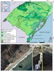
A. Map of study area. The map in the upper-left corner highlights the state of Rio Grande do Sul, located in the southernmost region of Brazil. The main map illustrates its phytogeographical regions, highlighting the municipality of Santa Vitória do Palmar and Hermenegildo Beach (star). B. View of Hermenegildo Beach (Google Earth Pro, 2023). The arrow indicates the location of the peat profile. C. Sampling of the 44 cm-thick peat profile.
FIELD SAMPLING
Sediment samples were collected along a 44 cm-thick peat sedimentary profile, which was exposed near the dune region at Hermenegildo Beach (Figure 1). The top of the outcrop was covered by sandy dunes with sparse herbaceous and shrub vegetation. The peat exhibited no lithological changes or disturbances throughout the profile. Sampling was performed using plastic syringes, inserted along the profile at regular 1 cm intervals from base to top, totaling 25 samples of 3 cm³ each. The syringes, properly labeled, were wrapped in plastic film to protect the samples and transported to the Laboratory of Palynology and Paleoceanography at the Universidade Federal de Rio Grande, where they were stored under refrigeration until preparation.
RADIOCARBON DATING
The 14C dating was performed at depths of 3 cm (top) and 44 cm (base) of the peat profile at the International Chemical Analysis (ICA) Inc. laboratory in Damascus, MD, USA, using accelerator mass spectrometry (AMS) to determine the ages. A Bayesian age-depth model was constructed using the rbacon package in R software, based on the 14C dates. This approach enabled associating each undated depth in the peat profile with a calibrated age (Blaauw and Christen, 2011). Radiocarbon ages were calibrated according to the Southern Hemisphere calibration curve, SHCal20 (Hogg et al., 2020). To ensure a detailed reconstruction of the sedimentary chronology, the profile was divided into 1 cm-thick layers.
PALYNOLOGICAL ANALYSIS
The palynological analysis was performed on samples from depths of 7, 15, 25, 35, and 39 cm. The chemical treatment followed a methodology adapted from Faegri and Iversen (1975), which included the addition of a Lycopodium clavatum tablet (lot number 100320 201, produced by the Department of Quaternary Geology at Lund University and calibrated in Sweden with 14,285 ± 3.51 spores/tablet) and the use of HCl (10%) and KOH (5%) to remove carbonates and humic acids, respectively. ZnCl2 was added to separate palynomorphs from the sediment. After chemical processing, five slides were prepared for each sample using glycerin jelly.
A minimum of 300 palynomorphs was counted per sample. The analyses were conducted using an optical microscope at 40× and 100× magnifications. Palynomorph identification was based on specialized literature (Leal et al., 2021; Leonhardt and Lorscheitter, 2007, 2008, 2010a; Lorente et al., 2017; Masetto and Lorscheitter, 2014; Mourelle and Prieto, 2016; Radaeski et al., 2014). For paleoenvironmental interpretation, the identified taxa were grouped into the following categories: bryophytes, pteridophytes, grassland herbs, herbaceous marsh, forest, indeterminate environments, algae, fungi, and indeterminate (when taxonomic identification was not possible).
Percentage and influx diagrams were generated using Tilia 3.0.3 software (Grimm, 1991-2022). Cluster analysis was performed using the CONISS software (Grimm, 1987) to identify similarities between samples and establish distinct zones. The pollen sum included taxa from grassland herbs, herbaceous marsh, forest, and indeterminate environments, whereas the total sum encompassed all categories. However, only taxa with percentages equal to or greater than 1.5% were displayed in the diagrams.
DIATOM ANALYSIS
For the diatom analysis, samples from depths of 5, 27, 37, and 41 cm were processed. The chemical treatment followed a methodology adapted from Metzeltin and García-Rodriguez (2003). HCl (20%) was added to the samples to remove carbonates, followed by four washes with boiled distilled water. Subsequently, H2O2 (35%) was added to eliminate organic matter. After this process, the samples were washed again with boiled distilled water until the supernatants became clear. A drop of formalin (4%) was added to each sample for the preparation of permanent slides. in total, five slides per sample were prepared using Canada balsam as the mounting medium.
A total of 200 diatom valves were counted per sample. The slides were examined under an optical microscope at 40× and 100× magnifications. Species identification was based on the works of Metzeltin and García-Rodríguez (2012), Silva et al. (2010), and other specialized literature. Ecological information related to taxa salinity preferences was derived from studies by Cuña-Rodríguez et al. (2018), Francesco et al. (2022), García-Rodríguez et al. (2004a, 2004b), Perez et al. (2018), Sunesen et al. (2017), and Tudurí et al. (2021).
The percentage diagram was generated using Tilia 3.0.3 software (Grimm, 1991-2022). Only taxa with percentages equal to or greater than 2% were displayed in the diagram. The data were correlated with the palynological zones established in the CONISS diagram, and for paleoenvironmental interpretation, the diatoms were grouped by their salinity preferences.
RESULTS
The base of the peat profile (44 cm) was dated to 4321 cal years BP, and the top of the profile (3 cm) was dated to 3903 cal years BP (Table 1). Thus, the peat profile corresponds to the Late Holocene, after the peak of the last Post-Glacial Marine Transgression (Tomazelli et al., 2000). According to the age-depth model, the peat accumulation rate was 10 years per cm (Figure 2).
Conventional radiocarbon ages (in years before present - yrs BP), calibrated ages (in calibrated years before Christ - cal yrs BC) and the mean age (in calibrated years before present - cal yrs BP) of the peat profile from Hermenegildo Beach, Santa Vitória do Palmar, RS (according to ICA).

Age-depth model for the peat profile from Hermenegildo Beach. The distribution of calibrated 14C dates is shown in blue. The grayscale shading represents the age-depth model, with darker areas indicating higher certainty. The red dashed line shows the mean model, while the dashed grey lines represent the 95% confidence intervals. The top-left panel displays the iterations of the Markov Chain Monte Carlo (MCMC) process. The top-center panel shows the sedimentation rate (in years per cm), and its prior (green curves) and posterior (grey histograms) distributions. The top-right panel illustrates the prior and posterior distributions for memory.
A total of 18 pollen taxa and 7 spore taxa belonging to Bryophytes and Pteridophytes were identified (Figure 3 and Table S1). Additionally, non-pollen palynomorphs, such as fungal spores and algae, were recorded. Regarding the diatom data, 21 taxa were identified (Figure 3 and Table S2).

A-H, palynomorphs: (A) Cyperaceae; (B) Poaceae; (C) Typha sp.; (D) Urticaceae/Moraceae; (E) Mimosa type; (F) undetermined trilete spore; (G) Botryococcus algae; (H) undetermined fungal spore. I-N, diatoms: (I) Caloneis cf. mendosina; (J) Pinnularia sp.; (K) Rhopalodia gibberula; (L) Cyclotella striata; (M) Diploneis chilensis; (N) Paralia sulcata. Scale bar: 15µm.
ZONE I (44-34 CM DEPTH / 4321-4206 CAL YRS BP)
This zone includes samples analyzed from depths of 41, 39, 37, and 35 cm.
Forest indicators were prominent at the beginning of the zone, with percentages ranging from 37.4% to 72%, dominated by Urticaceae/Moraceae (24.7-38.5%) and Mimosa type (12.6-32.6%), but showed a decrease towards the end of the interval (Figure 4). A similar trend was observed in the concentration of forest indicators, which were higher at the beginning of the zone and decreased significantly towards the end of the interval (Figure 5). Herbaceous marsh components recorded higher percentages in this zone, ranging from 1.5% to 15.5%, with greater concentrations in this interval. Juncaceae was the most representative taxon, accounting for 12%, though it was recorded in only one sample. Typha sp. ranged from 0.7% to 3% and showed a high concentration per gram of sediment (Figures 4 and 5). Grassland indicators had lower percentages at the beginning of the interval but increased towards the end (26%-45.4%). The predominant taxa were Cyperaceae (14%-33%) and Poaceae (8%-11.5%), followed by Amaranthaceae (1%-2%) (Figure 4). However, in terms of pollen concentration, grassland taxa had low representation, especially towards the end of the interval. Among them, Amaranthaceae had the highest concentration at the beginning of the zone (Figure 5). Fungal spores (9.3%-10.3%) had relatively low percentages compared to later zones and remained constant throughout the interval (Figure 4). In terms of concentration, fungi also showed reduced expression, especially towards the end of the zone (Figure 5). Pteridophyte spores (3.3%-5%) and algae (0.7%-1%) had low percentages compared to other indicators. However, they reached their highest concentrations per gram of sediment at the beginning of this interval, followed by a significant decrease towards the end (Figures 4 and 5).

Palynological percentage diagram of the peat profile from Hermenegildo Beach, showing the main taxa, group sums, zones, dendrogram, chronology (including two radiocarbon dates and estimated ages from the age-depth model), depth, and lithology.

Palynological concentration diagram (grains/g) of the peat profile from Hermenegildo Beach, showing the main taxa, group sums, zones, dendrogram, chronology (including two radiocarbon dates and estimated ages from the age-depth model), depth, and lithology. For better visualization, all values in the graph have been divided by 10.
For diatoms, the predominant species was Diploneis chilensis, ranging from 53.5% to 83.5%, reaching its highest percentage within this interval, especially at the base of the profile. Paralia sulcata (4%-17.5%), Pinnularia sp. (0.5%-4%), and Rhopalodia gibberula (1%-7.5%) had lower percentages at the beginning of the zone but increased towards the end of the interval. Other taxa, such as Amphora sp. (0.5%-2%), Cyclotella striata (0.5%-1.5%), Navicula sp. (0%-2.5%), and Terpsinoë americana (0%-3.5%), were also recorded, although they were less abundant (Figure 6).

The percentage diagram showing the main diatom taxa found in the peat profile from Hermenegildo Beach. The data correlated with the three established palynological zones. On the left are the depth, lithology, and chronology (including two radiocarbon dates and estimated ages from the age-depth model) of the peat profile.
ZONE II (34-16 CM DEPTH / 4206-4018 CAL YRS BP)
This zone includes samples analyzed from depths of 27 and 25 cm.
In this interval, forest indicators drastically decreased in both percentage (2.1%) and concentration. Conversely, grassland indicators reached their highest percentage (94%), with Cyperaceae (64.4%) being the most prominent, followed by Poaceae (21.2%), Amaranthaceae (4.8%), Eryngium sp. (2.1%), and Asteraceae (1.4%) (Figure 4). However, despite their high percentage in this zone, the pollen concentration of grassland indicators, including Cyperaceae, remained low. Among these taxa, Amaranthaceae maintained the highest concentration (Figure 5). The percentage of herbaceous marsh components declined (3.4%), as did their concentration, with only Typha sp. present, which continued to exhibit a high concentration (Figures 4 and 5). Fungal spores showed a significant increase in percentage (28%), but their concentration per gram of sediment remained low (Figures 4 and 5). Pteridophyte spores maintained a low percentage (5%) and concentration, while algae, mainly represented by Botryococcus sp., showed a slight percentage increase (2.7%) and a significant rise in concentration compared to the end of Zone I (Figures 4 and 5).
Regarding diatoms, Diploneis chilensis (13%) and Rhopalodia gibberula (2.5%) declined sharply in this interval compared to the previous zone. Navicula sp. (12.5%) and Pinnularia sp. (12.5%) showed a slight increase. Amphora sp. (8.5%) and Cyclotella striata (27%) reached their highest occurrence in this zone (Figure 6).
ZONE III (16-3 CM DEPTH / 4018-3903 CAL YRS BP)
This zone includes samples analyzed from depths of 15, 7, and 5 cm.
In this interval, forest indicators increased again in percentage, especially towards the end of the zone (14.7%-26%), with Urticaceae/Moraceae being the most prominent (13.2%-26%) and a smaller contribution from Arecaceae (0%-1.5%) (Figure 4). This increase is also reflected in the concentration diagram (Figure 5). Herbaceous grassland indicators showed a slight decrease in percentages compared to Zone II (82.4%-74%). Cyperaceae exhibited a marked decrease towards the top of the profile (31%-51.5%), while Poaceae reached its highest percentage at the end of the zone (17%-34.5%). Asteraceae increased significantly (7.2%-8%), while Eryngium sp. (1.4%-4.4%) and Scrophulariaceae (0%-1.5%) decreased towards the end of the zone (Figure 4). However, the concentration diagram shows an increase in the grassland indicators towards the top of the profile (Figure 5). Herbaceous marsh components reached their lowest percentage (0%-2.2%), with only Typha sp. present (Figure 4). The concentration diagram also revealed a significant reduction of these components towards the end of the interval, with Typha sp. showing high concentrations at the beginning of the zone but a sharp decrease by the end (Figure 5). Fungal spores remained stable in percentage (24.7%-25.7%), slightly lower than in the previous zone. However, they exhibited the highest concentration at the end of the zone (Figures 4 and 5). Pteridophyte spores (1.3%-6%) and algae (0.3%-2.3%) started with similar percentages to Zone II but decreased towards the end of the interval (Figure 4), although their concentrations were higher compared to the previous zone (Figure 5).
Regarding diatoms, Caloneis cf. mendosina, which had not previously shown significant records, stood out in this zone, reaching a high expression (53%). Caloneis westii was also recorded, but with a lower percentage (2.5%). Diploneis chilensis showed a slight increase compared to the previous zone (17%). The percentage of Cyclotella striata decreased significantly in this interval (1.5%), and Navicula sp. was not recorded in this zone (0%), while Pinnularia sp. maintained a similar percentage to Zone II (12%) (Figure 6).
DISCUSSION
The results indicate the existence of a paleolagoon from 4321 cal yrs BP - Late Holocene (Figure 7), associated with the onset of the regressive phase of the coastal region following the last Post-Glacial Marine Transgression, which occurred between 6000 and 5000 cal yrs BP (Angulo and Lessa, 1997; Angulo et al., 2006; Dillenburg et al., 2004; Lima et al., 2013; Martin et al., 2003; Tomazelli et al., 2000).

Schematic reconstruction of the paleoenvironmental evolution of the paleolagoon based on palynomorph and diatom data from the peat profile at Hermenegildo Beach. Zone I (4321-4206 cal yrs BP): humid climate with high precipitation favored forest and herbaceous marsh vegetation; diatoms indicate brackish-freshwater conditions. Zone II (4206-4018 cal yrs BP): drier conditions led to vegetation decline; local vegetation was dominated by Typha sp., and diatoms indicate brackish-marine conditions. Zone III (4018-3903 cal yrs BP): return to humid conditions favored forest and grassland expansion; the paleolagoon returned to brackish-freshwater conditions. After 3903 cal yrs BP, the system was buried by eolian deposits.
The forest and grassland indicators were classified as part of the regional vegetation, as they reflect the typical vegetation patterns of the southern region of Brazil, characterizing a broader area. In contrast, the herbaceous marsh indicators, which include vegetation associated with flooded areas, were related to the local vegetation of the paleolagoon, representing a more specific ecosystem adapted to the local hydric conditions (Costa, 1998; Fiaschi and Pirani, 2009; IBGE, 2012; Masetto and Lorscheitter, 2019; Overbeck et al., 2007).
ZONE I (4321-4206 CAL YRS BP)
At the beginning of this phase, humid climatic conditions and high precipitation favored the development of predominantly forested regional vegetation, with a notable presence of taxa such as Urticaceae/Moraceae and Mimosa type, as evidenced in the percentage and concentration diagrams. Paleoclimatic studies conducted by Gorenstein et al. (2022) and Prado et al. (2013), using biological, physicochemical, and isotopic proxies, indicate that from the Late Holocene (5000 cal yrs BP to present), southern South America experienced a wetter climate with increased precipitation. Additionally, El Niño-Southern Oscillation (ENSO) events became more frequent and intense from 5000 cal yrs BP onwards, contributing to regional rainfall increases (Gyllencreutz et al., 2010; Woodroffe et al., 2003). The significant development of local vegetation, characterized by an herbaceous marsh, as highlighted in the concentration diagram, as well as the high concentrations of pteridophytes at the beginning of the interval, also reflect warm and humid conditions (Leal and Lorscheitter, 2007; Macedo et al., 2007; Medeanic and Corrêa, 2010; Masetto and Lorscheitter, 2019; Roth et al., 2021). In contrast, grassland vegetation was sparse, represented in the percentage diagram mainly by Cyperaceae and Poaceae (Figure 7 - Zone I).
The predominance of the diatom Diploneis chilensis and the high concentration of the green alga Botryococcus sp., both typical of brackish to freshwater environments, indicate that the paleolagoon was shallow and had low salinity at the beginning of the interval (Francesco et al., 2022; Friz, 2008; Medeanic, 2006). Benthic diatoms such as Diploneis chilensis are more abundant in shallow water columns, where light penetration reaches the sediment-water interface (Fritz, 2008; Stone and Fritz, 2004). The high representation of Botryococcus sp. in the concentration diagram further supports this interpretation, as this microalga prefers shallow aquatic environments (Marcos et al., 2022; Medeanic, 2006; Pisera et al., 2020) (Figure 7 - Zone I).
Towards the end of the interval, a decline in the concentration of most pollen (grassland and forest vegetation) and non-pollen indicators (pteridophytes, algae, and fungi) was observed, suggesting the onset of a drier climatic phase with reduced precipitation (Behling et al., 2005; Iriarte, 2006; Leonhardt and Lorscheitter, 2010a, 2010b). The percentage diagram also shows a decrease in forest taxa, although less pronounced than in the concentration diagram. In contrast, the herbaceous marsh reached its peak development, with the predominance of Typha sp. and Juncaceae, as demonstrated by the percentage and concentration diagrams. The paleolagoon conditions became slightly more saline, as indicated by the subtle increase in the percentage of the diatom Paralia sulcata, which is associated with brackish-marine environments (Cuña-Rodríguez et al., 2020; García-Rodríguez et al., 2004a, 2004b; Medeanic et al., 2009). However, Diploneis chilensis remained dominant, despite a slight reduction in its percentage (Figure 7 - Zone I).
ZONE II (4206-4018 CAL YRS BP)
The low representation of both grassland and forest indicators, as demonstrated by the concentration diagram, suggests the persistence of a dry climate with reduced precipitation (Behling et al., 2005; Iriarte, 2006; Leonhardt and Lorscheitter, 2010a, 2010b). Additionally, the low pollen concentration in this zone indicates a reduction in vegetation cover. Among grassland herbs, Amaranthaceae exhibited the highest concentration during this interval. In percentage terms, this family also reached its highest value in Zone II, although its proportion remained low compared to other taxa. The increase in Amaranthaceae in pollen records is associated with drier paleoclimatic conditions, characterized by lower precipitation and higher salinity in water bodies, as many species in this family are linked to halophytic environments (Iriarte, 2006; Prieto, 2000; Song et al., 2022). Iriarte (2006) observed an alternation between dry and humid periods in southeastern Uruguay (Rocha Province) between 6620 and 4020 cal yrs BP, based on peaks of Amaranthaceae/Chenopodiaceae. At 4020 cal yrs BP, the highest peak of this group was recorded, indicating a period of increased aridity. After 4020 cal yrs BP, the study suggested a more stable and humid climate for the region. The apparent greater development of grassland vegetation (mainly Cyperaceae) and fungi, as shown in the percentage diagram, reflects the low pollen concentration in these samples. Since the total number of preserved pollen grains was reduced, the predominance of Cyperaceae among the few recorded grains may have distorted the percentage results, making them proportionally higher despite their lower absolute concentrations (Lorscheitter and Roth, 2013) (Figure 7 - Zone II).
Local vegetation, represented by the herbaceous marsh, also declined, as indicated by both percentage and concentration diagrams. However, Typha sp. maintained high concentrations and reached its highest percentage value in this interval, although still lower compared to other taxa. Shallow water bodies, subject to small fluctuations in water level, may favor the dominance of Typha sp. in wetlands. Typha domingensis (Pers.), native to South America, can grow in a wide range of flooding depths, from 0 to 115 cm. Dry periods reduce water availability in wetlands, potentially leading to greater colonization by this species, which can survive even with a 50% reduction in water potential in the substrate. Thus, the high representation of Typha sp. in Zone II reinforces the hypothesis of a drier climate (Chen et al., 2010, 2013; Cruz et al., 2019; Cruz et al., 2023; Lishawa et al., 2010) (Figure 7 - Zone II)
The dominance of Cyclotella striata and the presence of Amphora sp. indicate increased salinity in the paleolagoon, as these taxa are characteristic of brackish to marine environments (Perez et al., 2018; Silva et al., 2010). However, the coexistence of diatoms from brackish-freshwater environments, such as Diploneis chilensis and Pinnularia sp., suggests that conditions remained mixed (Francesco et al., 2022; García-Rodríguez et al., 2004a, 2004b). Navicula sp. had its highest frequency in this zone; however, since it includes species that occur in environments with varying salinities, its presence did not allow for the inference of a specific salinity (Tudurí et al., 2021). Masetto and Lorscheitter (2019), in their palynological analyses of relict muddy sediments on Hermenegildo Beach, reported an increase in the influx of marine palynomorphs during the early regressive phase of the coastline (between 4000-2000 cal yrs BP). According to the authors, proximity to the present-day sea meant that the studied paleoenvironment was one of the last sites under marine influence during the regression. However, in the peat profile of the present study, no marine palynological indicators were identified, only diatoms from brackish-marine environments. Moreover, there is no lithological evidence in the profile indicating a marine incursion. Thus, it is more likely that the increase in salinity in the paleolagoon resulted from the drier climatic conditions that began at the end of Zone I, which favored a higher evaporation rate and, consequently, the salinization of the paleoenvironment (Figure 7 - Zone II).
ZONE III (4018-3903 CAL YRS BP)
The climate once again exhibited warmer and more humid conditions, with increased precipitation. This pattern is evident in the concentration diagram, especially at the end of the interval, when regional vegetation, composed of grassland taxa (particularly Asteraceae, Cyperaceae, Poaceae, and Eryngium sp.) and forest taxa (Arecaceae and Urticaceae/Moraceae), expanded. The return of forest taxa is also visible in the percentage diagram. Additionally, the high concentrations of pteridophytes and fungi further support a warm and humid climate (Macedo et al., 2007; Masetto and Lorscheitter, 2019; Roth et al., 2021). Paleopalynological studies conducted in the central-southern (Masetto and Lorscheitter, 2019; Medeanic and Corrêa, 2010) and northern (Behling et al., 2004, 2005; Leal and Lorscheitter, 2007; Leonhardt and Lorscheitter, 2010b; Macedo et al., 2007; Roth et al., 2021) portions of the Coastal Plain of Rio Grande do Sul indicate that, from 4000 cal yrs BP onward, increases in temperature and humidity favored the expansion of both grassland and forest vegetation. The increase in rainfall and humidity in the region may be linked to new ENSO events (Gyllencreutz et al., 2010; Woodroffe et al., 2003). The local herbaceous marsh experienced a significant decline during this interval, as evidenced by the concentration and percentage diagrams. However, some grassland indicators, such as Cyperaceae and Poaceae, may still be associated with the herbaceous marsh, as these taxa are also found in wetland environments (Seeliger et al., 2004) (Figure 7 - Zone III).
The paleolagoon experienced a decrease in salinity, returning to brackish-freshwater conditions, likely due to increased precipitation. This shift is evidenced by the substantial reduction in brackish-marine diatoms during this interval and the dominance of diatoms associated with lower salinity environments, such as Caloneis cf. mendosina, which appeared in high percentages in this zone, as well as Diploneis chilensis and Pinnularia sp. (Francesco et al., 2022; García-Rodríguez et al., 2004a, 2004b; Sunesen et al., 2017) (Figure 7 - Zone III).
From 3903 cal yrs BP onward, the paleolagoon and its associated herbaceous marsh were buried due to aeolian processes, leading to the incursion of sand into lagoonal deposits in the southern Coastal Plain of Rio Grande do Sul (Lima et al., 2013; Masetto and Lorscheitter, 2019). This burial process interrupted vegetation succession and contributed to the infilling of the study site. Masetto and Lorscheitter (2019) highlight that even if the burial of the lagoonal deposits at Hermenegildo had not occurred, the vegetation succession of the region’s paleolagoons would not have resulted in the development of a tropical forest, unlike that recorded in the northern portion of the Coastal Plain of Rio Grande do Sul (Leal and Lorscheitter, 2007; Roth et al., 2021). This is because the study area, located at a higher latitude, with lower temperatures and proximity to the coastline, has limiting factors for the development of a tropical forest (Lorscheitter, 2003; Masetto and Lorscheitter, 2019) (Figure 7 - Zone III).
CONCLUSION
Palynological and diatom analyses conducted on the peat profile from Hermenegildo Beach (Santa Vitória do Palmar) enabled the reconstruction of the ecological succession of a paleolagoon located in the southernmost portion of the CPRS during the early Late Holocene, between 4321 and 3903 cal yrs BP. The palynological data provided insights into both regional (grassland and forest indicators) and local (herbaceous marsh) paleovegetation. The identified diatoms were particularly useful for characterizing the paleolagoon, especially regarding its salinity.
Between 4321 and 4206 cal yrs BP, at the beginning of the regressive phase of the Coastal Plain, the local vegetation was characterized by an herbaceous marsh, primarily composed of Typha sp. and Juncaceae. The regional vegetation consisted of forests and sparse grasslands. A warm and humid climate, accompanied by increased precipitation, favored the development of arboreal taxa. These climatic conditions may be associated with the intensification of ENSO events during the Late Holocene. The records also indicate that the paleolagoon was shallow and initially favored the development of brackish to freshwater diatoms and green algae. By the end of this interval, a decline in forest and grassland indicators, as well as other groups (pteridophytes, algae, fungi), marked the onset of a drier climatic phase characterized by reduced precipitation.
Between 4206 and 4018 cal yrs BP, the decline of both regional (grasslands and forests) and local (herbaceous marsh) vegetation, along with the high representation of Amaranthaceae and Typha sp., reinforces the scenario of a dry climate with low precipitation. Additionally, the paleolagoon exhibited an increase in salinity, as indicated by the significant presence of the diatom Cyclotella striata, which is associated with brackish-marine environments. However, no marine palynological indicators or lithological changes were observed in the peat profile to suggest a marine incursion during the initial regression phase. It is likely that the persistence of drier conditions led to an increased evaporation rate, resulting in the salinization of the paleolagoon.
Between 4018 and 3903 cal yrs BP, both grassland and forest vegetation expanded once again. Pteridophytes and fungi also reached high concentrations. These results suggest the return of warmer and more humid climatic conditions, with increased precipitation, possibly associated with new ENSO events. These findings align with other paleoenvironmental studies conducted in Rio Grande do Sul, indicating a more stable and humid climate from 4000 cal yrs BP onward. Although the herbaceous marsh reached its lowest extent during this zone, families of herbaceous grassland plants, such as Cyperaceae and Poaceae, adapted to flooded environments, were still present and may represent the local vegetation. The presence of brackish-freshwater diatoms, combined with a significant reduction in brackish-marine diatoms, indicates a decrease in the salinity of the paleolagoon.
After 3903 cal yrs BP, the paleolagoon and its associated herbaceous marsh were buried by aeolian deposits, interrupting vegetation succession in the study area. Even if burial had not occurred, the vegetation succession would not have led to the formation of a tropical forest, as factors such as the region’s higher latitude and proximity to the coastline would have limited its development.
The peat profile spans a period of 418 years, providing high temporal resolution. Although it encompasses a relatively short time span, this study highlights the value of palynological and diatom microfossil analyses in advancing the understanding of coastal paleoenvironmental dynamics, particularly in the southernmost portion of the CPRS, where paleopalynological studies remain scarce. The results offer important insights into how climate changes-especially decadal-scale events such as ENSO-and coastal processes during the Late Holocene shaped the region’s paleovegetation dynamics.
SUPPLEMENTARY MATERIALS
Table S1 is available at: https://doi.org/10.5281/zenodo.16878030. Table S2 is available at: https://doi.org/10.5281/zenodo.16878221.
ACKNOWLEDGMENTS
The authors acknowledge the Programa de Pós-Graduação em Oceanologia at FURG for the opportunity and support that made this study possible. We are also grateful to the anonymous reviewers whose suggestions helped improve the final version of the manuscript.
REFERENCES
-
Angulo, R. J. & Lessa, G. C. 1997. The Brazilian sea-level curves: a critical review with emphasis on the curves from the Paranaguá and Cananéia regions. Marine Geology, 140(1-2), 141-166. DOI: https://doi.org/10.1016/S0025-3227(97)00015-7
» https://doi.org/10.1016/S0025-3227(97)00015-7 -
Angulo, R. J., Lessa, G. C. & Souza, M. C. 2006. A critical review of mid-to late-Holocene sea-level fluctuations on the eastern Brazilian coastline. Quaternary Science Reviews, 25(5-6), 486-506. DOI: https://doi.org/10.1016/j.quascirev.2005.03.008
» https://doi.org/10.1016/j.quascirev.2005.03.008 -
Battarbee, R. W. 2000. Palaeolimnological approaches to climate change, with special regard to the biological record. Quaternary Science Reviews , 19(1-5), 107-124. DOI: https://doi.org/10.1016/S0277-3791(99)00057-8
» https://doi.org/10.1016/S0277-3791(99)00057-8 - Battarbee, R. W., Jones, V. J., Flower, R. J., Cameron, N. G., Bennion, H., Carvalho, L. & Juggins, S. 2001. Diatoms. In: Smol, J. P., Birks, H. J. B., Stoermer, E. F. (Ed.) Tracking environmental change using lake sediments. Volume 3: Terrestrial, Algal and Siliceous Indicators (pp. 155-201). Dordrecht: Kluwer Academic Publishers.
-
Blaauw, M. & Christen, J. A. 2011. Flexible paleoclimate age-depth models using an autoregressive gamma process. Bayesian Analysis, 6(3), 457-474. DOI: https://doi.org/10.1214/11-BA618
» https://doi.org/10.1214/11-BA618 -
Bracco, R., Inda, H., Puerto, L., Castiñeira, C., Sprechmann, P. & García-Rodríguez, F. 2005. Relationships between Holocene sea-level variations, trophic development, and climatic change in Negra Lagoon, Southern Uruguay. Journal of Paleolimnology, 33, 253-263. DOI: https://doi.org/10.1007/s10933-004-4934-8
» https://doi.org/10.1007/s10933-004-4934-8 -
Behling, H., Villar, V. D. & Orloci, L. 2004. Late Quaternary Araucaria Forest, grassland (campos), fire and climatic dynamics, studied by high-resolution pollen, charcoal and multivariate analysis of the Cambará do Sul core in southern Brazil. Palaeogeography, Palaeoclimatology, Palaeoecology, 203(3-4), 277-297. DOI: https://doi.org/10.1016/S0031-0182(03)00687-4
» https://doi.org/10.1016/S0031-0182(03)00687-4 -
Behling, H., Villar, V. D. & Bauermann, S. G. 2005. Late Quaternary grassland (campos), gallery forest, fire, and climate dynamics, studied by pollen, charcoal and multivariate analysis of the São Francisco de Assis Core in Western Rio Grande do Sul (Southeastern Brazil). Review of Palaeobotany and Palynology, 133(3-4), 235-248. DOI: https://doi.org/10.1016/j.revpalbo.2004.10.004
» https://doi.org/10.1016/j.revpalbo.2004.10.004 -
Calliari, L. J. & Klein, A. H. 1993. Características morfodinâmicas e sedimentológicas das praias oceânicas entre Rio Grande e Chuí, RS. Pesquisas em Geociências, 20(1), 45-56. https://doi.org/10.22456/1807-9806.21281
» https://doi.org/10.22456/1807-9806.21281 -
Chen, H., Zamorano, M. F. & Ivanoff, D. 2010. Effect of flooding depth on growth, biomass, photosynthesis, and chlorophyll fluorescence of Typha domingensis. Wetlands, 30, 957-965. DOI: https://doi.org/10.1007/s13157-010-0094-y
» https://doi.org/10.1007/s13157-010-0094-y -
Chen, H., Zamorano, M. F. & Ivanoff, D. 2013. Effect of deep flooding on nutrients and non-structural carbohydrates of mature Typha domingensis and its post-flooding recovery. Ecological Engineering, 53, 267-274. DOI: https://doi.org/10.1016/j.ecoleng.2012.12.056
» https://doi.org/10.1016/j.ecoleng.2012.12.056 - Corrêa, I. C. S., Weschenfelder, J., Toldo Jr., E. E., Baitelli, R. & Santos-Fischer, C. B. 2015. Gênese de um depósito de turfa na plataforma continental do Rio Grande do Sul-Brasil. Quaternary and Environmental Geosciences, 6(2), 1-9.
- Costa, C. S. B. 1998. Plantas de marismas e terras alagáveis. In: Seeliger, U., Odebrecht, C. & Castello, J. P. (Ed.) Os ecossistemas costeiro e marinho do extremo sul do Brasil (pp. 25-29). Rio Grande: Ecoscientia.
-
Cruz, Y. D. C., Scarpa, A. L. M., Pereira, M. P., Castro, E. M. & Pereira, F. J. 2019. Growth of Typha domingensis as related to leaf physiological and anatomical modifications under drought conditions. Acta Physiologiae Plantarum, 41(64), 1-9. DOI: https://doi.org/10.1007/s11738-019-2858-1
» https://doi.org/10.1007/s11738-019-2858-1 -
Cruz, Y. D. C., Scarpa, A. L. M., Díaz, A. S., Pereira, M. P., Castro, E. M. & Pereira, F. J. 2023. Influence of seasonal variation to the population growth and ecophysiology of Typha domingensis (Typhaceae). Journal of Plant Research, 136(5), 665-678. DOI: https://doi.org/10.1007/s10265-023-01468-2
» https://doi.org/10.1007/s10265-023-01468-2 -
Cuña-Rodríguez, C., Piovano, E., Puerto, L., Inda, H. & García-Rodríguez, F. 2018. On the relationship between Holocene environmental variability and the diatom composition in the Peña Lagoon, SE Uruguay. Ameghiniana, 55(4), 423-436. DOI: https://doi.org/10.5710/AMGH.06.06.2018.3126
» https://doi.org/10.5710/AMGH.06.06.2018.3126 -
Cuña-Rodriguez, C., Piovano, E. L., García-Rodríguez, F., Sylvestre, F., Rostek, F., Bernasconi, S. M. & Ariztegui, D. 2020. Paleolimnological record of the Pampean plains (Argentina) as a natural archive of South American hydroclimatic variability since the LGM to the Current Warm Period. Quaternary Science Reviews , 250, 106675. DOI: https://doi.org/10.1016/j.quascirev.2020.106675
» https://doi.org/10.1016/j.quascirev.2020.106675 - Dillenburg, S. R., Roy, P. S., Cowell, P. J. & Tomazelli, L. J. 2000. Influence of antecedent topography on coastal evolution as tested by the shoreface translation-barrier model (STM). Journal of Coastal Research, 16(1), 71-81.
-
Dillenburg, S. R., Esteves, L. S. & Tomazelli, L. J. 2004. A critical evaluation of coastal erosion in Rio Grande do Sul, Southern Brazil. Anais da Academia Brasileira de Ciências, 76(3), 611-623. DOI: https://doi.org/10.1590/S0001-37652004000300014
» https://doi.org/10.1590/S0001-37652004000300014 - Dillenburg, S. R., Barboza, E. G., Tomazelli, L. J., Hesp, P. A., Clerot, L. C. P. & Ayup-Zouain, R. N. 2009. In: Dillenburg, S. R., Hesp, P. A. (Ed.), Geology and Geomorphology of Holocene Coastal Barriers of Brazil (v. 107, pp. 53-91). Berlin: Springer.
-
Dillenburg, S. R., Barboza, E. G., Rosa, M. L. C., Caron, F. & Sawakuchi, A. O. 2017. The complex prograded Cassino barrier in southern Brazil: Geological and morphological evolution and records of climatic, oceanographic and sea-level changes in the last 7-6 ka. Marine Geology , 390, 106-119. DOI: http://dx.doi.org/10.1016/j.margeo.2017.06.007
» http://dx.doi.org/10.1016/j.margeo.2017.06.007 -
Dillenburg, S. R., Barboza, E. G., Hesp, P. A., Rosa, M. L. C., Caron, F. & Guadagnin, F. 2024. The progradational Curumim barrier in southern Brazil: an archive of sea-level changes, and cyclic aeolian activity in the Holocene. Geomorphology, 448, 109028. DOI: https://doi.org/10.1016/j.geomorph.2023.109028
» https://doi.org/10.1016/j.geomorph.2023.109028 -
Esteves, L. S. & Santos, I. R. 2002. Impacto econômico da erosão na praia do Hermenegildo (RS), Brasil. Pesquisas em Geociências , 28(2), 393-403. DOI: https://doi.org/10.22456/1807-9806.20313
» https://doi.org/10.22456/1807-9806.20313 - Faegri, K. & Iversen, J. 1975. Text-book of Pollen Analysis. Blackwell Scientific Publications.
-
Fiaschi, P. & Pirani, J. R. 2009. Review of plant biogeographic studies in Brazil. Journal of Systematics and Evolution, 47(5), 477-496. DOI: https://doi.org/10.1111/j.1759-6831.2009.00046.x
» https://doi.org/10.1111/j.1759-6831.2009.00046.x -
Francesco, C. G., Stutz, S., Hassan, G. S., Tonello, M. S., Vuichard, G. S., Bonavita, M. I., García-Rodríguez, F. & Fontana, S. L. 2022. Climate, sea-level and anthropogenic processes controlling the environmental evolution of shallow lakes in the southeastern Pampa plain (South East South America) during the last 12 ka. Journal of South American Earth Sciences, 116, 103856. DOI: https://doi.org/10.1016/j.jsames.2022.103856
» https://doi.org/10.1016/j.jsames.2022.103856 -
Fritz, S. C. 2008. Deciphering climatic history from lake sediments. Journal of Paleolimnology , 39, 5-16. DOI: https://doi.org/10.1007/s10933-007-9134-x
» https://doi.org/10.1007/s10933-007-9134-x -
García-Rodríguez, F. & Witkowski, A. 2003. Inferring sea level variation from relative percentages of Pseudopodosira kosugii in Rocha Lagoon, SE Uruguay. Diatom Research, 18(1), 49-59. DOI: http://dx.doi.org/10.1080/0269249X.2003.9705572
» http://dx.doi.org/10.1080/0269249X.2003.9705572 -
García-Rodríguez, F., Metzeltin, D., Sprechmann, P., Trettin, R., Stams, G. & Beltrán-Morales, L. F. 2004a. Upper Pleistocene and Holocene paleosalinity and trophic state changes in relation to sea level variation in Rocha Lagoon, southern Uruguay. Journal of Paleolimnology , 32, 117-135. DOI: https://doi.org/10.1023/B:JOPL.0000029427.36286.d9
» https://doi.org/10.1023/B:JOPL.0000029427.36286.d9 -
García-Rodríguez, F., Sprechmann, P., Metzeltin, D., Scafati, L., Melendi, D.L., Volkheimer, W., Mazzeo, N., Hiller, A., von Tumpling, W. & Scasso, F. 2004b. Holocene trophic state changes in relation to sea level variation in Lake Blanca, SE Uruguay. Journal of Paleolimnology , 31, 99-115. DOI: https://doi.org/10.1023/B:JOPL.0000013281.31891.8e
» https://doi.org/10.1023/B:JOPL.0000013281.31891.8e -
Gorenstein, I., Prado, L. F., Bianchini, P. R., Wainer, I., Griffiths, M. L., Pausata, F. S. & Yokoyama, E. 2022. A fully calibrated and updated mid-Holocene climate reconstruction for Eastern South America. Quaternary Science Reviews , 292, 107646. DOI: https://doi.org/10.1016/j.quascirev.2022.107646
» https://doi.org/10.1016/j.quascirev.2022.107646 -
Grimm, E. C. 1987. CONISS: a Fortran 77 Program for stratigraphically constrained cluster analysis by the method of incremental sum of squares. Computers & Geosciences, 13, 13-35. DOI: http://dx.doi.org/10.1016/0098-3004(87)90022-7
» http://dx.doi.org/10.1016/0098-3004(87)90022-7 - Grimm, E. C. 1991-2022. TILIA and TILIA Software [computer program], 3.0.3 Version. Illinois State Museum, Research and Collections Center, Springfield, 62703, USA.
-
Gyllencreutz, R., Mahiques, M. M., Alves, D. V. P. & Wainer, I. K. C. 2010. Mid- to late-Holocene paleoceanographic changes on the southeastern Brazilian shelf based on grain size records. The Holocene, 20, 863-875. DOI: https://doi.org/10.1177/0959683610365936
» https://doi.org/10.1177/0959683610365936 -
Hao, X., Li, L., Ouyang, X., Qin, L., Jiang, X., Li, J. & Wang, F. 2022. Holocene vegetation evolution, hydrologic variability and sea-level fluctuations on the south coastal plain of Laizhou Bay, Bohai Sea, China: new evidence from pollen, freshwater algae and dinoflagellate cysts. Journal of Paleolimnology , 68(1), 155-167. DOI: https://doi.org/10.1007/s10933-021-00229-2
» https://doi.org/10.1007/s10933-021-00229-2 -
Hapsari, K. A., Biagioni, S., Jennerjahn, T. C., Reimer, P. M., Saad, A., Achnopha, Y., Sabiham, S. & Behling, H. 2017. Environmental dynamics and carbon accumulation rate of a tropical peatland in Central Sumatra, Indonesia. Quaternary Science Reviews , 169, 173-187. DOI: https://doi.org/10.1016/j.quascirev.2017.05.026
» https://doi.org/10.1016/j.quascirev.2017.05.026 -
Hogg, A. G., Heaton, T. J., Hua, Q., Palmer, J. G., Turney, C. S., Southon, J., Bayliss, A., Blackwell, P. G., Boswijk, G., Ramsey, C. B., Pearson, C., Petchey, F., Reimer, P., Reimer, R. & Wacker, L. 2020. SHCal20 Southern Hemisphere calibration, 0-55,000 years cal BP. Radiocarbon, 62(4), 759-778. DOI: https://doi.org/10.1017/RDC.2020.59
» https://doi.org/10.1017/RDC.2020.59 -
Inda, H., García-Rodríguez, F., del Puerto, L., Acevedo, V., Metzeltin, D., Castiñeira, C., Bracco, R. & Adams, J. B. 2006. Relationships between trophic state, paleosalinity and climatic changes during the first Holocene marine transgression in Rocha Lagoon, Southern Uruguay. Journal of Paleolimnology , 35, 699-713. DOI: https://doi.org/10.1007/s10933-005-4841-7
» https://doi.org/10.1007/s10933-005-4841-7 -
Inda, H., García-Rodríguez, F., Del Puerto, L., Stutz, S., Figueira, R. C. L., Ferreira, P. A. L. & Mazzeo, N. 2016. Discriminating between natural and human-induced shifts in a shallow coastal lagoon: A multidisciplinary approach. Anthropocene, 16, 1-15. DOI: https://doi.org/10.1016/j.ancene.2016.09.003
» https://doi.org/10.1016/j.ancene.2016.09.003 - IBGE (Instituto Brasileiro de Geografia e Estatística). 2012. Manual Técnico da Vegetação Brasileira. 2. ed. Rio de Janeiro, IBGE.
-
Iriarte, J. 2006. Vegetation and climate change since 14,810 14C yr BP in southeastern Uruguay and implications for the rise of early Formative societies. Quaternary Research, 65(1), 20-32. DOI: https://doi.org/10.1016/j.yqres.2005.05.005
» https://doi.org/10.1016/j.yqres.2005.05.005 -
Leal, M. G. & Lorscheitter, M. L. 2007. Plant succession in a forest on the Lower Northeast Slope of Serra Geral, Rio Grande do Sul, and Holocene palaeoenvironments, Southern Brazil. Acta Botanica Brasilica, 21(1), 1-10. DOI: https://doi.org/10.1590/S0102-33062007000100001
» https://doi.org/10.1590/S0102-33062007000100001 -
Leal, A., Martínez-Blanco, X., Beri, Á. & Puerto, L. 2021. A combined catalog of non-pollen palynomorphs (NPPs) of fungal origin from soil and airborne samples of Uruguay. Review of Palaeobotany and Palynology , 293, 104488. DOI: https://doi.org/10.1016/j.revpalbo.2021.104488
» https://doi.org/10.1016/j.revpalbo.2021.104488 -
Leonhardt, A. & Lorscheitter, M. L. 2007. Palinomorfos do perfil sedimentar de uma turfeira em São Francisco de Paula, Planalto Leste do Rio Grande do Sul, Sul do Brasil. Revista Brasileira de Botânica, 30(1), 47-59. DOI: https://doi.org/10.1590/S0100-84042007000100006
» https://doi.org/10.1590/S0100-84042007000100006 -
Leonhardt, A. & Lorscheitter, M. L. 2008. Pólen de gimnospermas e angiospermas do perfil sedimentar de uma turfeira em São Francisco de Paula, Planalto Leste do Rio Grande do Sul, Sul do Brasil. Revista Brasileira de Botânica , 31(4), 645-658. DOI: https://doi.org/10.1590/S0100-84042008000400010
» https://doi.org/10.1590/S0100-84042008000400010 -
Leonhardt, A. & Lorscheitter, M. L. 2010a. Pólen de Magnoliopsida (Asteridae) e Liliopsida do perfil sedimentar de uma turfeira em São Francisco de Paula, Planalto Leste do Rio Grande do Sul, Sul do Brasil. Revista Brasileira de Botânica , 33(3), 381-392. DOI: https://doi.org/10.1590/S0100-84042010000300002
» https://doi.org/10.1590/S0100-84042010000300002 -
Leonhardt, A. & Lorscheitter, M. L. 2010b. The last 25,000 years in the Eastern Plateau of Southern Brazil according to Alpes de São Francisco record. Journal of South American Earth Sciences , 29(2), 454-463. DOI: https://doi.org/10.1016/j.jsames.2009.09.003
» https://doi.org/10.1016/j.jsames.2009.09.003 -
Lima, L. G., Dillenburg, S. R., Medeanic, S., Barboza, E. G., Rosa, M. L. C. C., Tomazelli, L. J., Dehnhardt, B. A. & Caron, F. 2013. Sea-level rise and sediment budget controlling the evolution of a transgressive barrier in southern Brazil. Journal of South American Earth Sciences , 42, 27-38. DOI: https://doi.org/10.1016/j.jsames.2012.07.002
» https://doi.org/10.1016/j.jsames.2012.07.002 -
Lima, L. G., Dillenburg, S., Buchmann, F. & Parise, C. 2020. O significado paleogeográfico das turfeiras costeiras do Rio Grande do Sul. Geociências, 39(2), 393-410. DOI: http://hdl.handle.net/10183/250200
» http://hdl.handle.net/10183/250200 -
Lishawa, S. C., Albert, D. A. & Tuchman, N. C. 2010. Water level decline promotes Typha × glauca establishment and vegetation change in Great Lakes coastal wetlands. Wetlands, 30, 1085-1096. DOI: https://doi.org/10.1007/s13157-010-0113-z
» https://doi.org/10.1007/s13157-010-0113-z - Lorente, F. L., Junior, A. A. B., Oliveira, P. E. & Pessenda, L. C. R. 2017. Atlas Palinológico - Laboratório C-14 - CENA/USP. São Paulo, Fealq.
- Lorscheitter, M. L. 2003. Contribution to the Holocene history of Atlantic rain forest in the Rio Grande do Sul state, southern Brazil. Revista del Museo Argentino de Ciencias Naturales, 5(2), 261-271.
-
Lorscheitter, M. L. & Roth, L. 2013. O uso da concentração polínica em interpretações paleoambientais. Anuário do Instituto de Geociências-UFRJ, 36(1), 80-84. DOI: http://dx.doi.org/10.11137/2013_1/2013_1_80_84
» http://dx.doi.org/10.11137/2013_1/2013_1_80_84 - Lowe, J. J. & Walker, M. 2014. Reconstructing Quaternary environments. Abingdon, Routledge.
- Macedo, R. B., Cancelli, R. R., Bauermann, S. G., Bordignon, S. D. L. & Neves, P. D. 2007. Palinologia de níveis do Holoceno da planície costeira do Rio Grande do Sul (localidade de Passinhos), Brasil. Gaea, 3(2), 68-74.
-
Marcos, M. A., Bamonte, F. P., Echeverría, M. E., Sottile, G. D. & Mancini, M. V. 2022. Changes in vegetation and human-environment interactions during the Holocene in the Lake Pueyrredón area (Southern Patagonia). Vegetation History and Archaeobotany, 31, 291-305. DOI: https://doi.org/10.1007/s00334-021-00854-x
» https://doi.org/10.1007/s00334-021-00854-x - Martin, L., Dominguez, J. M. & Bittencourt, A. C. 2003. Fluctuating Holocene sea levels in eastern and southeastern Brazil: evidence from multiple fossil and geometric indicators. Journal of Coastal Research , 19(1), 101-124.
- Martins, L. R. & Martins, I. R. 2004. Presença de turfa na plataforma continental do Rio Grande do Sul. Gravel, 2, 77-85.
-
Masetto, E. & Lorscheitter, M. L. 2014. Palynomorphs in Holocene sediments from a paleolagoon in the coastal plain of extreme southern Brazil. Acta Botanica Brasilica , 28(2), 165-175. DOI: https://doi.org/10.1590/S0102-33062014000200003
» https://doi.org/10.1590/S0102-33062014000200003 -
Masetto, E. & Lorscheitter, M. L. 2019. Vegetation dynamics during the last 7500 years on the extreme southern Brazilian coastal plain. Quaternary International, 524, 48-56. DOI: https://doi.org/10.1016/j.quaint.2019.07.009
» https://doi.org/10.1016/j.quaint.2019.07.009 -
Medeanic, S. 2006. Freshwater algal palynomorph records from Holocene deposits in the coastal plain of Rio Grande do Sul, Brazil. Review of Palaeobotany and Palynology , 141(1-2), 83-101. DOI: https://doi.org/10.1016/j.revpalbo.2006.03.012
» https://doi.org/10.1016/j.revpalbo.2006.03.012 - Medeanic, S. & Corrêa, I. C. 2010. Climatic changes in the coastal plain of the Rio Grande do Sul state in the Holocene: palynomorph evidences. Pan-American Journal of Aquatic Sciences, 5(2), 115-125.
- Medeanic, S., Dillenburg, S. R. & Toldo Jr., E. E. 2001. Novos dados palinológicos da transgressão marinha pós-glacial em sedimentos da laguna dos patos, RS, Brasil. Revista Geociências, 6(6), 64-76.
- Medeanic, S., Jankovska, V. & Dillenburg, S. R. 2003. The implication of green algae [Chlorophyta] for palaeoecological reconstruction of the Holocene lagoon system in the Tramandai Lagoon Region, Rio Grande do Sul, Brazil. Acta Palaeobotanica, 43(1), 113-123.
-
Medeanic, S., Carvalho Torgan, L., Pinheiro Clerot, L. C. & Bahi dos Santos, C. 2009. Holocene marine transgression in the coastal plain of Rio Grande do Sul, Brazil: palynomorph and diatom evidence. Journal of Coastal Research , (251), 224-233. DOI: https://doi.org/10.2112/07-0935.1
» https://doi.org/10.2112/07-0935.1 - Metzeltin, D. & García-Rodríguez, F. 2003. Las Diatomeas Uruguayas. Montevideo, Facultad de Ciencias.
- Metzeltin, D. & García-Rodríguez, F. 2012. Las Diatomeas Uruguayas. 2. ed. Montevideo, Facultad de Ciencias .
-
Mourelle, D. & Prieto, A. R. 2016. Pollen and spores from surface samples in the campos region of Uruguay and their paleoecological implications. Acta Botanica Brasilica , 30(3), 351-370. DOI: https://doi.org/10.1590/0102-33062016abb0117
» https://doi.org/10.1590/0102-33062016abb0117 - Nimer, E. 1989. Climatologia da região sul: introdução à climatologia dinâmica - subsídios à geografia regional do Brasil. In: Climatologia do Brasil (pp. 195-263). Rio de Janeiro, IBGE .
-
Oliveira‐Filho, A. T. & Fontes, M. A. L. 2000. Patterns of floristic differentiation among Atlantic Forests in Southeastern Brazil and the influence of climate. Biotropica, 32(4b), 793-810. DOI: https://doi.org/10.1111/j.1744-7429.2000.tb00619.x
» https://doi.org/10.1111/j.1744-7429.2000.tb00619.x -
Overbeck, G. E., Müller, S. C., Fidelis, A., Pfadenhauer, J., Pillar, V. D., Blanco, C. C. & Forneck, E. D. 2007. Brazil’s neglected biome: the South Brazilian Campos. Perspectives in Plant Ecology, Evolution and Systematics, 9(2), 101-116. DOI: https://doi.org/10.1016/j.ppees.2007.07.005
» https://doi.org/10.1016/j.ppees.2007.07.005 -
Perez, L., Brugnoli, E., Muniz, P., Sunesen, I., Sar, E. A., Crisci, C., Cuña, C. & García-Rodríguez, F. 2018. Diatom assemblages from surface sediments of the Río de la Plata estuary, Uruguay. New Zealand Journal of Marine and Freshwater Research, 52(3), 383-397. DOI: https://doi.org/10.1080/00288330.2017.1417318
» https://doi.org/10.1080/00288330.2017.1417318 -
Pisera, A., Siver, P. A. & Mandic, O. 2020. Miocene siliceous microfossils from the open cast coal mine Gračanica (Bugojno paleolake, Bosnia and Herzegovina) and their significance: a preliminary report. Palaeobiodiversity and Palaeoenvironments, 100, 507-517. DOI: https://doi.org/10.1007/s12549-019-00378-3
» https://doi.org/10.1007/s12549-019-00378-3 -
Prieto, A.R. 2000. Vegetational history of the Late Glacial-Holocene transition in the grasslands of eastern Argentina. Palaeogeography, Palaeoclimatology, Palaeoecology , 157(3-4), 167-188. DOI: https://doi.org/10.1016/S0031-0182(99)00163-7
» https://doi.org/10.1016/S0031-0182(99)00163-7 -
Prado, L. F., Wainer, I., Chiessi, C. M., Ledru, M. P. & Turcq, B. 2013. A mid-Holocene climate reconstruction for eastern South America. Climate of the Past, 9(5), 2117-2133. DOI: https://doi.org/10.5194/cp-9-2117-2013
» https://doi.org/10.5194/cp-9-2117-2013 -
Radaeski, J. N., Evaldt, A. C. P., Bauermann, S. G. & Lima, G. L. 2014. Diversidade de grãos de pólen e esporos dos Campos do sul do Brasil: descrições morfológicas e implicações paleoecológicas. Iheringia, Série Botânica, 69(1), 107-132. DOI: https://isb.emnuvens.com.br/iheringia/article/view/8
» https://isb.emnuvens.com.br/iheringia/article/view/8 -
Recasens, C., Ariztegui, D., Maidana, N. I. & Zolitschka, B. 2015. Diatoms as indicators of hydrological and climatic changes in Laguna Potrok Aike (Patagonia) since the Late Pleistocene. Palaeogeography, Palaeoclimatology, Palaeoecology , 417, 309-319. DOI: https://doi.org/10.1016/j.palaeo.2014.09.021
» https://doi.org/10.1016/j.palaeo.2014.09.021 -
Ribeiro, V., Sommer, M. G., Menegat, R., Kuhn, L. A., Simões, J. C., Braga, R. B., Bauermann, S. G. & Silva, W. G. D. 2020. Fire events and vegetation dynamics during the late Pleistocene-Meghalayan interval in the southernmost Brazilian coastal plain comments on the endocranial morphology. Revista Brasileira de Paleontologia, 23(4), 234-250. Available from: Available from: http://hdl.handle.net/10183/229945 Access date: 2025 Aug. 1.
» http://hdl.handle.net/10183/229945 -
Ribeiro, V., Guerra-Sommer, M., Menegat, R., Simões, J. C., Kuhn, L. A., Barboza, E. G. & Marcon, G. T. G. 2024. Pleistocene-Holocene climatic events on the inner coastal plain of southernmost Brazil in relation to marine isotopic stages. Journal of South American Earth Sciences , 137, 104857. DOI: https://doi.org/10.1016/j.jsames.2024.104857
» https://doi.org/10.1016/j.jsames.2024.104857 -
Roth, L., Lorscheitter, M. L. & Masetto, E. 2021. Paleoenvironments of the last 24,000 years on the extreme northern Rio Grande do Sul coastal plain, southern Brazil. Quaternary International , 571, 117-126. DOI: https://doi.org/10.1016/j.quaint.2020.11.024
» https://doi.org/10.1016/j.quaint.2020.11.024 - Salgado-Labouriau, M. L. 1994. História ecológica da Terra. São Paulo, Edgard Blücher.
- Seeliger, U., Cordazzo, C. & Barcellos, L. 2004. As marismas. In: Areias do Albardão: um guia ecológico ilustrado do litoral no Extremo Sul do Brasil (pp.78-83). Rio Grande, Ecoscientia.
-
Silva, J. G. D., Torgan, L. C. & Cardoso, L. D. S. 2010. Diatomáceas (Bacillariophyceae) em marismas no sul do Brasil. Acta Botanica Brasilica , 24(4), 935-947. DOI: https://doi.org/10.1590/S0102-33062010000400008
» https://doi.org/10.1590/S0102-33062010000400008 -
Song, X., Su, Y., Zheng, J., Zhang, Z., Liang, Z. & Tang, Z. 2022. Study on the effects of salt tolerance type, soil salinity and soil characteristics on the element composition of Chenopodiaceae halophytes. Plants, 11(10), 1288. DOI: https://doi.org/10.3390/plants11101288
» https://doi.org/10.3390/plants11101288 -
Stone, J. R. & Fritz, S. C. 2004. Three‐dimensional modeling of lacustrine diatom habitat areas: Improving paleolimnological interpretation of planktic: benthic ratios. Limnology and Oceanography, 49(5), 1540-1548. DOI https://doi.org/10.4319/lo.2004.49.5.1540
» ttps://doi.org/10.4319/lo.2004.49.5.1540 -
Sunesen, I., Tardivo Kubis, J. A. & Sar, E. A. 2017. A re-investigation of three Frenguelli’s Caloneis taxa (Pinnulariaceae, Bacillariophyta) from Argentina. Phytotaxa, 305(3), 165-178. DOI: http://dx.doi.org/10.11646/phytotaxa.305.3.4
» http://dx.doi.org/10.11646/phytotaxa.305.3.4 -
Tomazelli, L. J., Dillenburg, S. & Villwock, J. A. 2000. Late Quaternary geological history of Rio Grande do Sul Coastal Plain, southern Brazil. Revista Brasileira de Geociências, 30(3), 474-476. DOI: http://dx.doi.org/10.25249/0375-7536.2000303474476
» http://dx.doi.org/10.25249/0375-7536.2000303474476 - Tomazelli, L. J., Dillenburg, S. R. & Villwock, J. A. 2006. Geological evolution of Rio Grande do Sul coastal plain, southern Brazil. Journal of Coastal Research , (39), 275-278.
-
Tudurí, A., Becoña, L. P., Venturini, N., Rodríguez-Gallego, L., García-Rodríguez, F., González, L., Lescano, C., Costa, S., Puerto, L. & Bergamino, L. 2021. Trophic assessment in South American Atlantic coastal lagoons: Linking water, sediment and diatom indicators. Marine Pollution Bulletin, 165, 112119. DOI: https://doi.org/10.1016/j.marpolbul.2021.112119
» https://doi.org/10.1016/j.marpolbul.2021.112119 - Villwock, J. A. & Tomazelli, L. J. 1995. Geologia costeira do Rio Grande do Sul. Notas Técnicas CECO/IG/UFRGS, 8, 1-45.
- Villwock, J. A. & Tomazelli, L. J. 2007. Planície costeira do Rio Grande do Sul: gênese e paisagem atual. In: Becker, F. G., Ramos, R. A., Moura, L. A. (Ed.) Biodiversidade: Regiões da Lagoa do Casamento e dos butiazais de Tapes, planície costeira do Rio Grande do Sul (pp.20-33). Brasília, DF, Ministério do Meio Ambiente.
-
Ruello, M. R., Cinque, A., Di Donato, V., Molisso, F., Terrasi, F. & Ermolli, E. R. 2017. Interplay between sea level rise and tectonics in the Holocene evolution of the St. Eufemia Plain (Calabria, Italy). Journal of Coastal Conservation, 21, 903-915. DOI: https://doi.org/10.1007/s11852-017-0558-9
» https://doi.org/10.1007/s11852-017-0558-9 -
Woodroffe, C. D., Beech, M. R. & Gagan, M. K. 2003. Mid-late Holocene El Niño variability in the equatorial Pacific from coral microatolls. Geophysical Research Letters, 30(7), 1358-1361. DOI: https://doi.org/10.1029/2002GL015868
» https://doi.org/10.1029/2002GL015868 -
Yao, Q., Liu, K.-B., Platt, W. J. & Rivera-Monroy, V. H. 2015. Palynological reconstruction of environmental changes in coastal wetlands of the Florida Everglades since the mid-Holocene. Quaternary Research , 83, 449-458. DOI: https://doi.org/10.1016/j.yqres.2015.03.005
» https://doi.org/10.1016/j.yqres.2015.03.005 -
Zhang, Z., Yao, Q., Xu, Q., Jiang, M. & Zhu, T. 2021. Hydrological and palynological evidence of wetland evolution on the Sanjiang Plain (NE China) in response to the Holocene East Asia summer monsoon. Catena, 203, 1-10. DOI: https://doi.org/10.1016/j.catena.2021.105332
» https://doi.org/10.1016/j.catena.2021.105332
-
DATA AVAILABILITY STATEMENT
All data are available from the corresponding author upon reasonable request.
-
FUNDING
Financial support was given by CAPES - Fundação Coordenação de Aperfeiçoamento de Pessoal de Nível Superior (process 88887.827515/2023-00) - and by the Núcleo de Excelência Marinha, GEOMAR - FAPES (no. 019/2022).
All data are available from the corresponding author upon reasonable request.


