
 Agricultural frontier and green grabbing: digital land grabbing in the Cerrados of Piauí
Abstract
The article examines the intertwined strategies of land and green grabbing in Southern Piauí, focusing on how the Sistema Nacional de Cadastro Ambiental Rural (SICAR) has been used as a normative and informational instrument for the illegal appropriation of land. We analyze the overlap of rural property areas and legal reserves with the territory of the Melancias Community (PI). Primary and secondary data, obtained through fieldwork, semi-structured interviews, participant observation, and technical visits to communities, agricultural companies, and governmental and civil society organizations, were employed. The study concludes that land and green grabbing in Southern Piauí do not occur without land grabbing. Instead of containing the advance of Cerrado deforestation, SICAR has become a mechanism for expanding the agricultural frontier, by facilitating fraudulent land appropriation under the guise of environmental preservation and as a means for large landowners to address environmental liabilities and access public agricultural financing policies. Moreover, fraudulent land registration in SICAR has hindered the demarcation of lands belonging to traditional peoples and communities, as exemplified by the situation of the Melancias Community.
Keywords:
Land grabbing; green grabbing; agricultural frontier; MATOPIBA.
Resumo
O artigo analisa as indissociáveis estratégias de land e green grabbing no Sul do Piauí, com foco no uso do Sistema Nacional de Cadastro Ambiental Rural (SICAR) como ferramenta normativa e informacional para a apropriação ilegal de terras. Para isso, analisamos a sobreposição de áreas de imóveis rurais e reservas legais sobre o território da Comunidade Melancias (PI). Foram utilizadas informações e dados primários, obtidos em trabalhos de campo, e secundários, disponíveis em fontes oficiais e relatórios de organizações sociais. Conclui-se que land e green grabbing no Sul do Piauí não ocorrem sem grilagem de terras. Ao invés de conter o avanço do desmatamento do Cerrado, o SICAR tornou-se mecanismo de expansão da fronteira agrícola, ao facilitar a apropriação fraudulenta de terras sob o pretexto de preservação ambiental e como forma de latifundiários sanarem passivos ambientais e acessarem as políticas públicas de financiamento agropecuário. Além disso, o registro fraudulento de terras no SICAR tem obstaculizado a demarcação de terras de povos e comunidades tradicionais como na situação analisada da Comunidade Melancias.
Palavras-chave:
Land grabbing; grilagem verde; fronteira agrícola; MATOPIBA.
Résumé
L'article examine les stratégies imbriquées d'accaparement des terres et des espaces verts dans le sud de Piauí, en se concentrant sur la manière dont le Sistema Nacional de Cadastro Ambiental Rural (SICAR) a été utilisé comme un instrument normatif et informatif pour l'appropriation illégale des terres. Nous analysons le chevauchement des zones de propriété rurale et des réserves légales avec le territoire de la communauté de Melancias (PI). Des données primaires et secondaires, obtenues par le biais de travaux sur le terrain, d'entretiens semi-structurés, d'observations participantes et de visites techniques dans les communautés, les entreprises agricoles et les organisations gouvernementales et de la société civile, ont été utilisées. L'étude conclut que l'accaparement des terres et des espaces verts dans le sud de Piauí ne se produit pas sans accaparement des terres. Au lieu de contenir l'avancée de la déforestation du Cerrado, le SICAR est devenu un mécanisme d'expansion de la frontière agricole, en facilitant l'appropriation frauduleuse des terres sous couvert de préservation de l'environnement et comme moyen pour les grands propriétaires fonciers de répondre aux passifs environnementaux et d'accéder aux politiques publiques de financement agricole. De plus, l'enregistrement frauduleux des terres dans le SICAR a entravé la démarcation des terres appartenant aux peuples et aux communautés traditionnelles, comme le montre la situation de la communauté de Melancias.
Mots-clés:
Accaparement des terres; grilagem verte; frontière agricole; MATOPIBA.
Introduction
The expansion of the agricultural frontier is a practice present in various parts of the world, particularly in countries of the Global South (Peluso; Lund, 2011; Rasmussen; Lund, 2018). In common, they share a history of expropriation and violent disputes over land control and frontier expansion. Such processes do not occur in empty spaces, but over pre-existing social systems, utilizing various methods for large-scale land appropriation (Kelly; Peluso, 2015; Ioris, 2023).
This article analyzes the inseparable strategies of land and green grabbing (Sauer; Borras Jr, 2016) employed by agricultural companies, financial investors, and farmers in the southern region of the state of Piauí, considered one of the last Brazilian agricultural frontiers in Cerrado areas (Hershaw; Sauer, 2023). We analyzed how the National Rural Environmental Registry System (SICAR) is used as a normative and informational instrument for illegal land grabbing. To this end, we identified and analyzed the overlap of rural property areas (registered in the Land Management System - SIGEF) and legal reserves (registered in SICAR) over the territory of the Melancias Community, composed of agro-extractive families self-identified as “ribeirinhos-brejeiros”, who have inhabited the region for over a century (Machado Jr., 2018). It is noteworthy how fraudulent digital registration has hindered the demarcation of the community's lands and led to the proliferation of territorial conflicts.
In general, the agricultural frontier can be defined as areas where monoculture production of agricultural commodities on large properties (soy, corn, etc.) expands over other land uses and resources, including degraded pastures, native forests, and non-capitalist modes of production, particularly on unclaimed lands. As Martins (1997) points out, it is a space of alterity and conflict, where different ways of life and cultural values intersect. For the author, it represents a physical and symbolic boundary between "us" and "them," and is permeated by tensions and negotiations that almost always result in unequal power relations.
It is possible to observe the rapid expansion of the territorial reach of agricultural frontiers in recent decades (Bernardes, 2015; Ioris, 2023). They expand tied to the possibilities of extracting and utilizing new resources (Rasmussen; Lund, 2018), under the continuous logic of capital accumulation (Ioris, 2018). This real spatial fix (Harvey, 2004; McMichael, 2012) involves successive changes in the dynamics of land and resource use, with a profound restructuring of existing social and ecological systems (Calmon, 2022), leading to the proliferation of renewed mechanisms of accumulation by dispossession (Harvey, 2004; Caceres, 2015; Frederiksen, T.; Himley, 2020).
For Peluso and Lund (2011), the main disputes revolve around privileged access to resources and land control. Hence the fact that agricultural frontiers are considered emblematic areas of the global phenomenon of land grabbing, that is, the large-scale capital control of vast tracts of land and natural resources in the face of the convergence of food, energy, and financial crises, the imperatives of climate change mitigation, and the pursuit of resources by new centers of global capital (Borras et al., 2012).
For Franco and Borras (2019), the phenomenon of land grabbing becomes “green” when the appropriation of resources under the market imperative is justified by environmental concerns. For the proponents of the term (Fairhead; Leach; Scoones, 2012), green grabbing can be understood as the appropriation, control, or privatization of natural resources, land, and traditional knowledge under the guise of environmental protection or climate change mitigation.
It is a process that occurs when powerful actors, such as corporations, governments, or non-governmental organizations, use the rhetoric of sustainability and environmental protection to justify the acquisition of land, forests, and natural resources from traditional peoples and communities. For the authors, the consequences of this phenomenon include the loss of access rights, environmental degradation, and social and economic marginalization. Additionally, green grabbing can lead to unsustainable exploitation of natural resources and the improper appropriation of traditional knowledge and practices, as analyzed by various authors (Corson; Macdonald; Neimark, 2013; Peluso; Lund, 2011).
As highlighted by Silva et al. (2023), this is the case with the registration of unclaimed lands in SICAR. By fulfilling the legal requirement to digitally register a native forest, fraudulent land appropriation is characterized as green grabbing. According to the New Brazilian Forest Code (Law No. 12.651/2012), the Legal Reserve represents a percentage of rural property areas that must be maintained with native vegetation coverage (20% of the total property area in the Cerrado Biome). This requirement has resulted in the formation of a land market for "environmental preservation" (GRAIN, 2019; 2020). Additionally, the delimitation of preservation areas overlapping regions historically occupied by traditional, Indigenous, and Quilombola communities has led to an escalation of conflicts (Pitta; Mendonça; Boechat, 2017; Spadotto et al., 2020).
According to the legislation, Legal Reserve areas must be mapped, digitized, and registered in SICAR. However, due to its self-declaratory nature (it is up to the supposed landowner to declare and register in the system), many farmers, companies, and investors use it as a form of strategic mapping, that is, as a way to fraudulently identify and appropriate certain areas (Bühler; Gautreau; Oliveira, 2022; Rajão et al., 2022).
The research methodology consisted of gathering and utilizing both primary and secondary data. In the first case, information was collected during three fieldwork sessions in the region between 2017 and 2019, through semi-structured interviews, participant and non-participant observation, and technical visits. Secondary data were gathered from official sources and reports from social organizations cited throughout the text. The delimitation of the territory claimed by the Community was conducted on-site together with a local leader during fieldwork carried out in 2019. Using a Global Positioning System (GPS) device, the boundary of the claimed territory was demarcated. Next, using official data available in SICAR and applying geoprocessing and cartography techniques2, we identified the overlap of rural property areas and legal reserves on the demarcated territory. Finally, we used the information gathered by the Association of Rural Workers’ Lawyers of Bahia (AATR) regarding the fraudulent origin of the titles of rural properties that overlap and surround the territory of Melancias3.
In addition to the Introduction and Final Considerations, the article is divided into three more sections. In the first section, we analyze how the registration of rural properties and Legal Reserve areas in SICAR is used as a means for illegal land appropriation, constituting a new mechanism of green grabbing. We also demonstrate the fraudulent nature of a large portion of these registrations and the newly created mechanisms for transforming private environmental preservation areas into financial assets. In the second section, we highlight the expansion of the agricultural frontier in the southern region of Piauí, emphasizing the coexistence and conflict between two opposing logics of land use. On one hand, the occupation of the plateaus by modern agricultural production in large estates, and on the other, the centuries-old forms of livelihood of traditional peoples and communities inhabiting the region’s wet valleys, based on vernacular knowledge of the ways to use the available natural resources. Finally, in the last section, we analyze the overlap of rural properties registered in digital systems such as SIGEF and SICAR over the territory claimed by the Melancias Community. In addition to highlighting the fraudulent nature of these registrations, we emphasize how the practice of green grabbing hinders the recognition and demarcation of the traditional territory of the Community by the State.
Digital Land and green grabbing: strategic mapping for land regularization purposes
SICAR is a national public electronic registry of a self-declaratory nature, whose purpose, according to official discourse, is to "create a database aimed at control, monitoring, environmental and economic planning, and combating deforestation" (Brazil, 2012). To monitor information on rural properties in the country, the New Forest Code made the registration of land in SICAR mandatory.
After registration in SICAR, it is possible to extract the “identity of the rural property” by linking a specific owner to a georeferenced perimeter, as well as identifying the quantity and location of the permanent preservation area and Legal Reserve. For this, it is necessary to digitize the rural property using GPS. In this way, it is possible to obtain information about rural properties (area, location, boundaries, owner, etc.), as well as the identification of the property’s environmental assets and liabilities, enabling the creation of new green markets (GRAIN, 2019).
However, due to its self-declaratory nature and the lack of verification of the information provided by the competent public authority-state environmental agencies are responsible for verifying and validating the information-the database is unreliable or barely trustworthy. Just to give an idea of the irregularities in SICAR, the area of the national territory eligible for registration, according to the Agricultural Census of the Brazilian Institute of Geography and Statistics - IBGE (2017), was 430.7 million hectares, but 580.3 million hectares were registered by October 2023, an area 34.7% larger than what actually exists for registration (SICAR, 2024). This discrepancy highlights the overlap of areas and the illegal encroachment of private individuals onto unallocated public lands (unclaimed) and the territories of traditional peoples and communities.
Although the SICAR does not confer any title or property rights over the registered area, it is a public record that links the land to possession. Through a Federal Government decree, the land regularization of up to 1,500 hectares per holder was authorized, allowing the issuance of private property titles over public lands based solely on the self-declaratory information provided by interested parties in SICAR (GRAIN, 2019). This benefits the supposed landowners who use the registration document, even if the title has not yet been validated, for various purposes, such as accessing public rural credit, obtaining authorization for crop commercialization, legitimizing irregular occupations, and facilitating the negotiation of fraudulently appropriated lands (Bühler; Gautreau; Oliveira, 2022; Tupiassu; Gros-Desormaux; Cruz, 2017).
We are facing a new pattern of digital land grabbing (GRAIN, 2020). To define land ownership rights, georeferencing technologies have been utilized, which are primarily accessible to wealthy farmers and corporate groups. After identifying the location of areas susceptible to illegal appropriation, efforts are made to regularize the land in order to obtain so-called "legal security" through real estate registries and competent public authorities (Ribeiro et al., 2021).
Additionally, the digital enclosure of certain areas has been used as a basis for transforming the socio-environmental value of land and its resources into financial assets (GRAIN, 2019). The compensation for Legal Reserves (RL) can also be carried out via financial markets on stock exchanges, through the acquisition of Environmental Reserve Quotas (CRA), which are certificates representing a designated area of protected native vegetation that can be used to offset a Legal Reserve obligation deficit on another property.
We are facing a market-based instrument that legitimizes private appropriation and assigns monetary value to a common good, the forests. However, paradoxically, as the organization GRAIN (2019) denounces, it ties environmental preservation to the dynamics of supply and demand, as the value of the financial title (CRA) increases in proportion to the decrease in the amount of existing native vegetation. In other words, the scarcer the traded asset, the higher its market value.
According to information available on the BVRio platform4, there are over 580 offers of Environmental Reserve Quotas, encompassing five million hectares of land. Additionally, BVRio created a futures market for quotas called Environmental Reserve Quota Development and Commercialization Contracts for Future Delivery (CRAFs). The contracts establish obligations between landowners with surplus Legal Reserves (sellers) and those who wish to acquire Environmental Reserve Quotas (CRAs) to meet the requirements of the Forest Code (buyers).
Through the CRAF, the seller is obligated to create the CRAs and deliver them to the buyer upon payment, at a price previously agreed upon between the parties. With the justification of increasing the liquidity of the titles, a secondary market based on CRAFs was also created, enabling the establishment of a speculative financial market around forest-backed securities.
Thus, the mechanisms of land privatization, with the creation of new green commodities (forests), generate tensions related to real estate speculation, the value of rural properties, and the creation of new land markets. In general, they occur in areas that were of little interest to large corporate groups, mostly inhabited by traditional peoples and communities, as in the case of the Melancias Community (analyzed below). The capture by the financial system and the corresponding environmental pressure on unclaimed lands, traditional territories, and settlements reflect incentives for the enclosure of areas, constituting renewed instruments of green grabbing.
The World Bank, in turn, is one of the main promoters of the creation of market instruments based on the justification of environmental preservation. In the case of the Brazilian Cerrado, the “Piauí Pillars of Growth and Social Inclusion” aims to standardize environmental and land regularization, as well as promote the digitalization of land. The Grain report (2019) highlights an investment of approximately US$45.5 million aimed at mitigating the factors causing climate change, contracted in loans for the registration of rural properties in SICAR in the state.
Furthermore, the NGO highlights that financial institutions and government entities have raised questions about the legality of including collective territories in SICAR, insisting on the individual registration of these areas as private rural properties. This has led to the virtual elimination of collective territories from mapping, since only a small portion, equivalent to 15.7% of the registered territory, was declared as Indigenous Lands, Quilombola Territories and territories occupied by traditional peoples and communities (SICAR, 2024).
This context, combined with duplicate land registrations, highlights the land instability in the country, legitimizing a land market based on questionable titles. At the same time, it emphasizes the State's lack of interest in land regularization based on the constitutional principle of fulfilling the social function of land, in particular, the allocation of vacant lands for agrarian reform purposes.
The registries, by serving as a basis for certifying ownership, facilitate the issuance of titles for guarantees and counterparts of private financing backed by assets created on rural properties. As the Grain report (2020) concludes, the digitalization of land governance, by establishing a connection between the georeferenced registry and the property registry, becomes the new basis and means of transacting new land values such as “environmental services” in the capital market.
The areas of expansion of the Brazilian agricultural frontier are among the main targets of corporate groups interested in these new markets, given the relatively lower price of land and the ease of appropriating areas not designated by the State. Below we demonstrate some concrete consequences of the inseparable phenomena of land and digital green grabbing on traditional peoples and territories, in particular, on the Melancias Community in the south of the state of Piauí.
Between Chapadas and Lowlands: agricultural frontier in the South of Piauí
The South of Piauí, also known as Cerrados Piauienses, is perhaps the Brazilian region where the environmental narrative, irregular land appropriation, the financialization of land and territorial conflicts emerge and combine most explicitly. This is one of the most recent areas of expansion of the agricultural frontier and one of the main targets of the current phenomenon of land and green grabbing (Frederico ; Alemida, 2019). It is also a region where the previously mentioned mechanisms of digital land fencing and fraudulent creation of Legal Reserves are frequent, due to the fragile land governance and the large stock of land not allocated by the State (Silva et al. 2023).
Before the expansion of modern grain agriculture at the beginning of the 21st century, most of the land in the region was unoccupied, that is, not incorporated into the private domain and not allocated by the public authorities (Aguiar et al., 2023). According to Mott (1985), during Colonial Brazil, the region was occupied mainly by indigenous groups. The first attempts at colonization occurred at the end of the 17th century with the establishment of the first cattle farms based on slave labor and the subsequent creation of sesmarias. However, most of the land was not actually occupied due to the large size of the territory and the relatively small number of farms.
After the country's independence (1822), during the 19th and 20th centuries, the state of Piauí established a series of policies and laws in an attempt to divide and demarcate public lands, such as: Law No. 450 of 1907, which provided for the process of dividing and demarcating public lands; Law No. 817 of 1914, which provided for the granting of loans for the demarcation of public lands; and Decree No. 21,082 of 1932, which transferred public lands and lands belonging to absentees to the State of Piauí (Ribeiro et al., 2021). However, the most significant event related to the governance and transfer of vacant lands to private individuals was the creation of the Piauí Development Company (COMDEPI), currently the Piauí Land Institute (INTERPI), in 1971.
The creation of COMDEPI coincides with the elaboration of a series of public policies by the Brazilian State with the aim of expanding the production of agricultural commodities in the Cerrado areas, for the benefit of companies, large producers and local landowners (Bernardes, 2007). With the aim of attracting farmers from other regions of the country to implement commodity monocultures in large areas, COMDEPI began to authorize the sale of public lands to interested individuals, through the implementation of agricultural projects considered productive (Reydon; Monteiro, 2006).
In the particular case of the southern region of Piauí, the expansion of productive areas accelerated, especially from the 2000s onwards. According to data from Municipal Agricultural Production (IBGE, 2024), the area planted with soybeans (the main agricultural commodity produced in the region) increased from around 40 thousand hectares to almost 900 thousand hectares between 2000 and 2022 (graph below), with production increasing from around 100 thousand tons to more than two million tons in the same period.

The main impetus for the expansion of the soybean planted area was the arrival of large producers from other regions of the country and agricultural companies controlled by institutional investors (Boechat; Pitta; Toledo; 2019; Spadotto et al., 2020). Along with capitalized agricultural producers, the presence of agricultural tradings companies also played a fundamental role in enabling the expansion of grain monoculture in the region (Alves, 2009), by ensuring producers the availability of credit and inputs, in addition to the logistics for the flow of crops (Castillo, 2007).
As a result, divisions of labor that were often contradictory and generated conflicts began to coexist in the region (Frederico; Almeida, 2019). While large producers and agricultural companies controlled by funds and financial capital are the vectors of the dominant rationality, and use force and violence to implement their accumulation projects, hundreds of communities resist, in an attempt to ensure their traditional forms of reproduction and control of the land (Azerêdo; Mitidiero, 2020; Alves, 2020).
While traditional communities, who call themselves ribeirinhos-brejeiros5 in the region - which denotes the relationship with the areas of springs and river courses - usually build their homes in the bottoms of the valleys (locally called Baixões), with the practice of non-patrimonial land control regimes6, capitalist agriculture occupied the plateau areas, with the establishment of large monoculture latifundia of agricultural commodities (Frederico, 2019). The riverside-marsh communities occupied the Baixões with a logic of land use based on vernacular knowledge (Porto-Gonçalves, 2019) based on time and the natural characteristics of the Cerrado. The presence of relatively fertile land and access to water facilitate the practice of subsistence crops (manioc, beans, rice, corn, fruits, vegetables, etc.), as well as animal husbandry (cattle, pigs, goats and poultry), artisanal fishing and plant extraction (Frederico, 2019).
The Chapadas, in turn, are interfluves, characterized by flat relief and altitudes generally above 800 m, originally covered by Cerrado vegetation, with edaphoclimatic conditions made favorable by the development of adapted agricultural cultivars. These are the areas where the advance of capitalist agriculture can be seen, which meets the rationality increasingly imposed by the financial market, with large-scale production based on the control of natural factors through technical and scientific innovations (Frederico, 2019). The figure below presents a simplified profile characteristic of the southern region of Piauí and the different forms of land use.

The figure represents the Baixões delimited by the Chapadas on both sides, as well as the coexistence, almost always conflicting, of productive arrangements that involve distinct logics and temporalities. In the center, the river course stands out, accompanied by the different vegetative extracts essential for the social reproduction of riverside communities, such as fishing, extractivism, subsistence agriculture and extensive livestock farming, while on the sides there is the presence of monoculture of agricultural commodities.
However, the Chapadas and Baixões have complementary uses that ensure the social reproduction of the traditional communities of the Cerrado (Eloy, 2016). Before the arrival of agribusiness, the Chapadas had large areas of native vegetation, predominantly consisting of uncultivated land. Traditional communities in the region considered these places as areas of common use, for sharing existing resources. These spaces were not used for agriculture or housing, but rather for hunting, extracting wood, fruits, medicinal plants and honey. In addition, many traditional communities in Piauí used to let their cattle loose in these areas at certain times of the year to take advantage of the natural pastures (Alves, 2001).
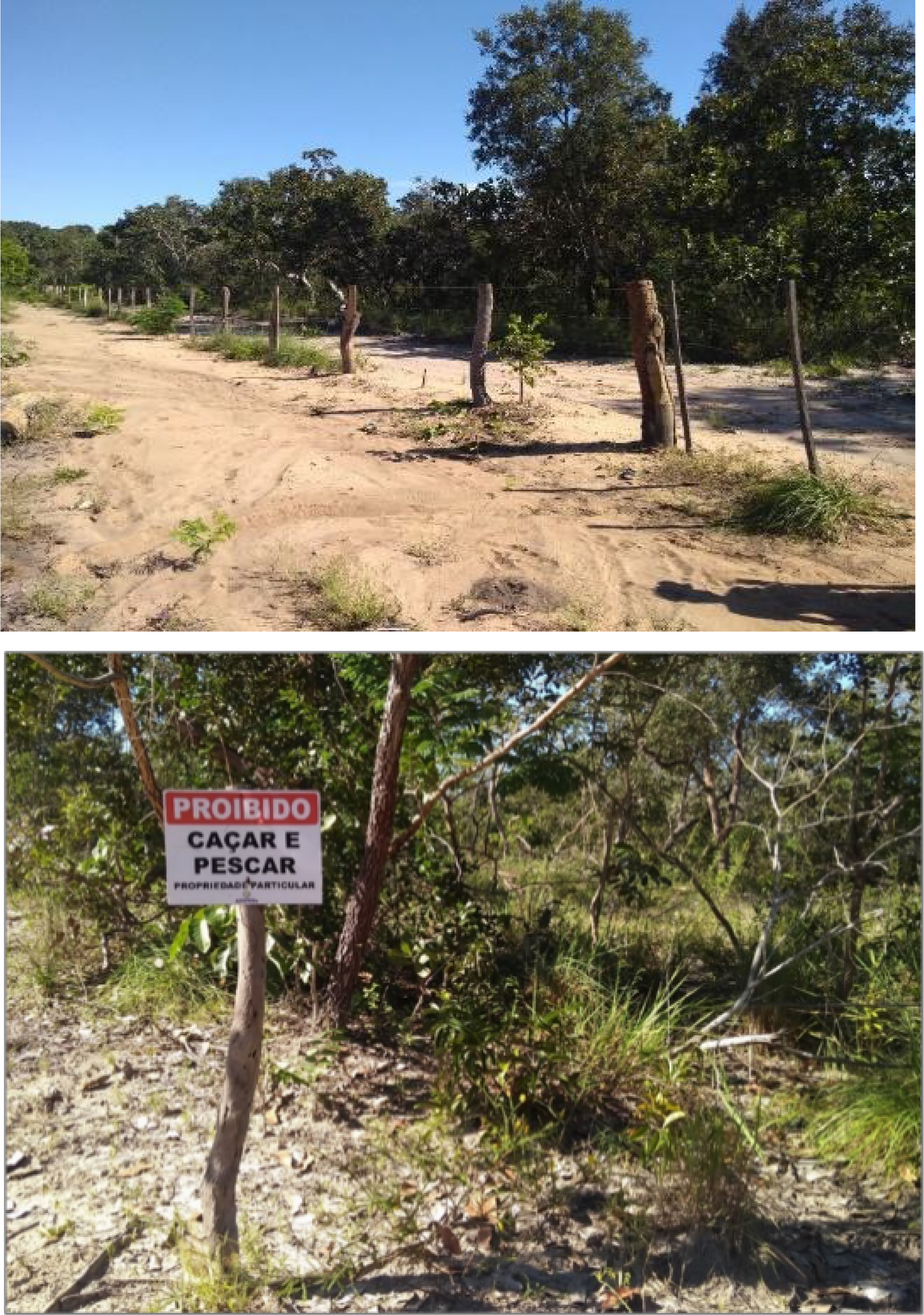
With almost all the areas of the Chapadas being earmarked for grain production, attempts at land and green grabbing also began to advance into the humid valleys (Alves, 2018; Frederico; Almeida, 2019). As a result, traditional peoples and communities have suffered direct interference from this new rationality: as well as being banned from using Chapada areas and suffering the environmental impacts of deforestation and the intensive use of pesticides (Alves, 2020), they have also experienced the digital enclosure of their lands to establish Legal Reserves for large farms (Bühler; Gautreau; Oliveira, 2022). In many cases, land enclosure is no longer restricted to digital delimitation, but landowners are also installing physical fences in various communities, as in the case of Melancias analyzed below.
Digital fencing, green grabbing and the Melancias Community (PI)
The Melancias community, located in the valleys of Piauí, is an example of resistance to the advance of the agricultural frontier, especially against the processes of land and green grabbing. According to oral accounts and technical reports7, the community's traditional possession of the territory began between the end of the 19th century and the beginning of the 20th century. According to Machado Jr. (2018), the occupation of the territory took place at three different times: a) the arrival of enslaved blacks before and shortly after the abolition of slavery in 1888, in search of places where they could rebuild their lives, away from the constant surveillance and threats of the former slave masters and the authorities; b) the migration of sertanejos displaced by the droughts in the Northeastern Sertão in the 1930s; c) and the intermittent migration of prospectors in the first half of the 20th century.
The migrants settled throughout the territory used by the Melancias community, intermarrying and surviving on subsistence crops, plant extraction, hunting and animal husbandry (Machado Jr., 2018). The territory is currently occupied by 53 families grouped into six nuclei: Melancias I and II, Sumidouro, Riacho dos Cavalos, Brejo das Éguas and Passagem da Nega. Because it is the main nucleus, with the largest number of families and the presence of a school and church, Melancias is the name used to describe the community and the territory formed by all the nuclei together.

The map shows the area claimed by the community for official recognition by the state of Piauí as the so-called Melancias Traditional Territory. In total, there are 22,583 hectares distributed between four municipalities in the state of Piauí: Santa Filomena, Gilbués, Bom Jesus and Baixa Grande do Ribeiro. Although the community has traditionally used the plateau areas for animal husbandry, hunting and extractivism, the deforestation of the Cerrado and its occupation by farms has meant that the territory required is restricted to the valley bottoms of the Uruçuí-Preto river (one of the main tributaries of the Parnaíba river) and some of its tributaries. The boundaries coincide with the edge of the plateaus that accompany the community on both sides, as can be seen in the following photograph taken from the southern boundary of the territory. On the left, the territory is delimited by the Serra Grande and Serra das Guaribas, and on the right, by the Serra do Quilombo and Chapada do Riachão.

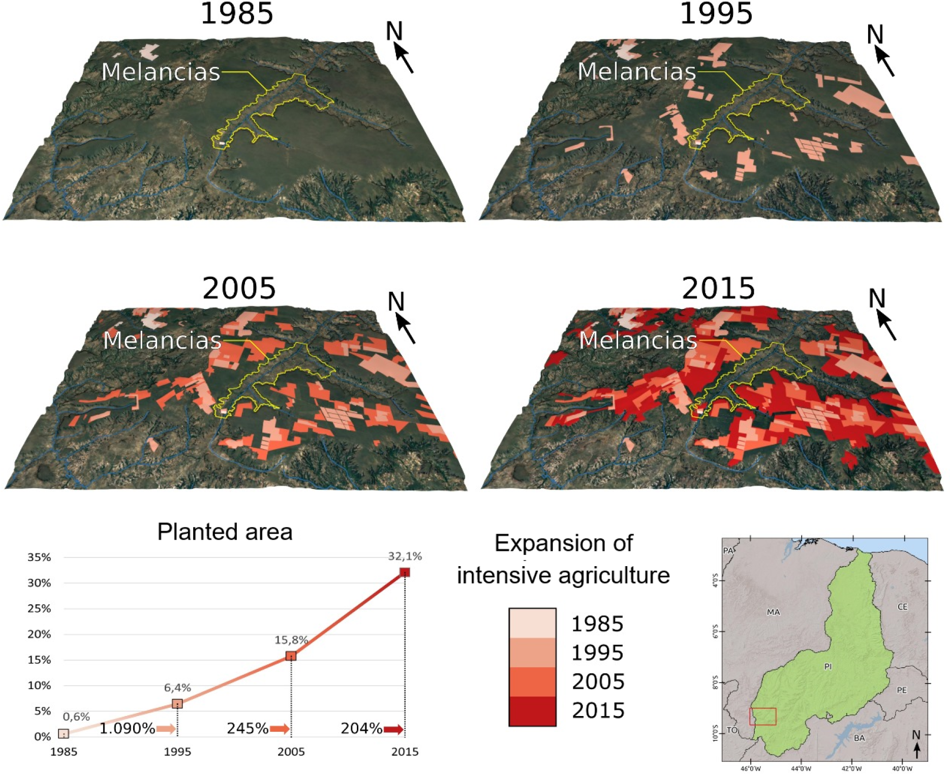
As in other locations, with the expansion of the agricultural frontier in the region, particularly since the 2000s, almost all of the plateau areas surrounding the community have been occupied by grain monoculture. As a result, families were forbidden to use or even access these areas, under threat from farmers and agricultural companies, resulting in a series of conflicts and constraints. The following block diagram shows the expansion of modern agricultural grain production around the territory of the Melancias Community.

Block diagram of the advance of grain monoculture on the plateaus surrounding the Melancias Territory.
The period between 1985 and 1995 saw the arrival of the first grain farms in the region. In 1985, as the first image shows, there were no farms in the immediate vicinity of the community's territory. The plateaus were predominantly covered by native Cerrado vegetation. However, in the 1995 image it is already possible to see some squared-off plots (shown in beige) of the first farms. Since then, the occupation of the plateaus by modern agriculture has grown significantly, as illustrated by the pictures from 2005 and 2015, with the area more than doubling in size every ten years. As you can see in the last image, since 2015 practically the entire area surrounding the Melancias Community has been occupied by monoculture grain farms.
During fieldworks carried out in the region between 2017 and 2019, community representatives pointed out a series of environmental changes resulting from the expansion of modern agriculture, among them: contamination by pesticides used on the farms, the proliferation of pests and diseases hitherto unknown to the community, erosion of the slopes and the silting up of the Uruçuí-Preto River caused by the deforestation of the Cerrado in the Chapadas.
In addition to the environmental damage, land grabbing, which initially prioritized the Chapadas, has recently started to advance into the Baixões as well. With almost all of the Chapada areas being earmarked for grain production, farmers and agricultural companies are seeking to appropriate areas of the Baixões, particularly for the establishment of Legal Reserves, as previously reported. This has resulted in the formation of a new land market with an interest in areas traditionally occupied by the community, which has generated even more conflicts.
In addition to the ban on access to the plateau areas, the communities are now also under pressure to leave their traditional territories. The image below shows a barbed wire fence placed inside the Melancias Community's territory by a neighboring farmer to demarcate the supposed boundary of his farm, followed by a photograph of a sign placed next to the fence with the words “No Hunting and Fishing - Private Property”.

Due to threats of expropriation and the use of violence by some farmers and companies, the families of the Melancias Community have been prevented from accessing some areas and resources that are fundamental to their subsistence within their own territory. As a result, the struggle for recognition and regularization of the traditional territory has become a crucial element for the community.
As a detailed analysis by Ribeiro et al. (2021), the farms in the surrounding area and with areas that extend into the community's territory have a series of irregularities. According to data gathered by the authors, based on INCRA's National Property Certification System (SNCI) and the Land Management System (SIGEF), there are 34 overlaps, totaling 19,923 hectares, or 87% of the territory claimed by the community.
Most of the owners claim that the origin of the chain of ownership of the alleged rural properties is the São Félix and Riachão “dates” (Sesmarias)8. However, as Ribeiro et al. (2021) show, these dates do not have a legal origin, i.e., they do not prove the moment when the public estate came into prominence9. As the authors found, they are the result of a judicial demarcation judged in 1953 without observing basic legal criteria, such as checking the legality of the title presented as a document of ownership of the respective area being divided. Other alleged rural properties overlapping the community claim to originate from another date called Murici, which, unlike the previous two, was not even judicially demarcated and is a fiction, with no regular chain of succession or proof of detachment from public property.
In addition to the falsification of the origin of rural properties through the indication of alleged dates and sesmarias, there are also properties created irregularly with the support of the state itself. This is the case of Gleba Serra Grande, located in Serra das Guaribas, on the left bank of the Uruçuí-Preto river, a territory traditionally occupied by the community's families. This is the use of legal instruments of state and national land policy in favor of select private groups. As the authors report, in 1973, COMDEPI demarcated and collected an impressive 2.4 million hectares of vacant land, including 756,000 hectares of the Serra Grande glebe. However, in order for these lands to be transferred to private individuals, authorization from the National Congress was required, granted by means of Resolution 36/1975 of the Federal Senate. However, the Resolution made the sale of these lands by the state of Piauí conditional on the prior regularization of the situation of the squatters located in the area, which was never done.
Thus, as former Judge Heliomar Rios10 of the Agrarian Court of the Bom Jesus District - who was responsible for analyzing the case - claims, without compliance with the clauses relating to the land regularization of the squatters, there is no way to recognize the legal value of the public deeds of purchase and sale originating from these titles. Before these lands could be sold by the state of Piauí to private individuals, it was necessary to recognize and regularize the lands traditionally occupied by dozens of communities along the Uruçuí-Preto river, such as the nuclei that make up the Melancias Community. Thus, it can be concluded that all of the rural properties surrounding the Melancias Community have fraudulent or at least irregular origins.
The situation becomes even more aggravating when companies and individuals use fraudulent and irregular titles to insert non-existent properties, or those with adulterated boundaries, into the digital registers (SICAR and SIGEF) on the territory claimed by the Community. Based on SICAR data, the area of Legal Reserve overlapping the territory of the Melancias Community is 19,029 hectares, which corresponds to more than 80% of the area claimed (Figure below).

Map of Rural Properties and Legal Reserve areas (SICAR) overlapping the Melancias Territory, Gilbués/PI, 2020.
Despite their fraudulent origins, most of the areas earmarked for Legal Reserves shown on the map, according to a survey carried out by Ribeiro et al. (2021), was registered in the property registry offices, which shows the connivance of the notaries in the neighboring municipalities. In this way, the link between the geo-referenced digital cadaster and the land registry becomes a means of linking land ownership, the provision of environmental services provided for by law and the capital market, becoming a clear mechanism for digital green grabbing.
On the community's side, according to documents in the possession of a local leader11, the demands for the demarcation and titling of the territory have been going on for over 30 years, including around nine protocols for filing lawsuits, with the first dating back to 1992. However, it wasn't until 2020, after strong pressure from the community from representatives of the state and the World Bank, with the support of non-governmental organizations and the Pastoral Land Commission, that Interpi opened an Administrative Discriminatory Action for land regularization in the Melancias Territory (Frederico; Almeida, 2019).
However, the three decades of omission by the state of Piauí in relation to land regularization requests has facilitated the fraudulent inclusion of alleged rural properties on the claimed territory, which makes the current land titling process difficult and time-consuming (Figure below). The Federal Court itself, through the Single Court of the Current Judicial Subsection, granted a request for an injunction in a public civil action (Case 1003719-20.2020.4.01. 4005) filed by the Federal Public Prosecutor's Office, pointing to the omission and responsibility of the National Institute for Colonization and Agrarian Reform (Incra) and the Piauí Land Institute (Interpi) in failing to promote land regularization in the Melancias Territory and thus contributing to social instability and land conflicts in the region12. In addition, the court demanded that Interpi adopt measures to re-establish order and social peace by recognizing the historically consolidated rights of the Melancias Community.

Map of INCRA - certified properties (SIGEF) superimposed on the Melancias Traditional Territory (PI), 2020.
The struggle of the families of the Melancias community to have their territory recognized has become an emblematic case of the violence suffered by traditional peoples and communities in the southern region of Piauí. In fact, the complaints made by the community, with the support of national organizations - the Social Network for Justice and Human Rights (REDE), the Association of Lawyers for Rural Workers of Bahia (AATR) and the Pastoral Land Commission (CPT) - and foreign organizations - Food First Information and Action Network (FIAN) and Genetic Resources Action International (GRAIN) - was one of the most important factors in forcing the World Bank to review its land regularization programme in the region, as well as the creation of State Land Regularization Law No. 7. 294 of 201913, replacing some provisions of Law 6.709 of 2015 by the state legislature.
The new rule stipulates that public and vacant state lands, which they collectively occupy, must be allocated to traditional communities, quilombolas and indigenous peoples. In addition to the amendment of the 2015 Law, another significant event for the region's traditional peoples and communities was the creation of the Land Regularization Centre of the Piauí State Court of Justice in 2016. These measures demonstrate official recognition of the complexity of the issue and reinforce the need for forceful action by the state.
With regard to the World Bank, as previously mentioned, since 2015 the state of Piauí has received support and funding from the institution with the aim of creating a land market via land regularization, through the aforementioned “Piauí Pillars of Growth and Social Inclusion”. The project provides for the geo-referencing of Piaui’s vacant land and the granting of title deeds to producers who occupy public land. Despite the Bank's denials in the face of complaints made by social organizations and communities in the region, the project was clearly aimed at granting so-called “legal security” to large landowners through the titling of illegally appropriated wastelands.
Under the aforementioned Law No. 6,709 of 2015, land titles were being awarded to large companies and agricultural producers at below-market prices, provided that they presented documents proving that they had occupied the area for more than five years and that they complied with the concept, applied in a rather subjective way, of the social function of the land. The granting of titles completely disregarded the fact that the land originated from fraudulent appropriation processes, as well as the historically consolidated presence of the communities (Frederico; Almeida, 2019).
However, even after the “recognition” by the state of Piauí of the need to allocate public lands to traditional peoples and communities (Law 7.294 of 2019), the change, at least in discourse, of the World Bank's guidelines for projects in the region, and the numerous complaints made by social organizations, land titling continues without a plausible outcome for the region's traditional communities. In the case of Melancias, in addition to the frequent threats and violence suffered by several families in the community, Interpi's management unexpectedly converted the Discriminatory Action into a Legal Action, which according to Ribeiro et al. (2021) makes the process even more time-consuming. The undue judicialization of the Administrative Action, without any minimum information on the history of occupation, the ways in which the territory is used and the number of families present in the Community, could make the process of recognition and delimitation of the territory unfeasible.
There are also other issues that make it difficult to demarcate the territory. As is common in traditional communities in the region, some families are enticed financially and ideologically by ranchers and agricultural companies to take a stand against collective demands. This is a recurring practice to destabilize communities politically by bringing neighboring families into conflict.
In the case of Melancias, there is a fragility of this type in the Sumidouro Nucleus14. The families of this locality did not agree to take part in the collective demand for the creation of the Melancias Territory, because they maintained close relations with a self-proclaimed owner of the locality - a large landowner in the region. They are only asking for 50 hectares, which correspond to the area around the houses and part of the marshland and footpaths. It is unclear what the counterpart is and what kind of relationship the families have with the landowner, but this situation represents another obstacle to the success of the claim for the creation of the traditional territory (Machado Jr., 2018).
Closing remarks
The integration of environmental conservation narratives, the application of geographic information tools and the practice of fraudulent land grabbing outline the National Rural Environmental Registration System (SICAR) as a tool for the neoliberalist of nature (Castree, 2003; Buhler; Oliveira, 2019), as it seeks to resolve environmental issues through approaches based on market principles.
Paradoxically, instead of curbing the advance of deforestation in the Cerrado, the system has become a mechanism for expanding the agricultural frontier by facilitating the fraudulent appropriation of land under the pretext of environmental preservation and as a way for landowners to remedy their environmental liabilities and access public agricultural financing policies. In fact, by allowing the Legal Reserve to be offset in areas with less potential for extracting income from the land, the Brazilian Forest Code, enacted in 2012, has stimulated the proliferation of new land and green grabbing mechanisms, especially in territories occupied by traditional peoples and communities, as well as on vacant land.
Initially conceived by the state with the aim of regularising land governance and guaranteeing environmental preservation, SICAR has been used as a strategic mapping mechanism, identifying areas susceptible to fraudulent appropriation. In addition to the expulsion of local communities, this practice has deepened property speculation and land concentration, as well as leading to the proliferation of conflicts.
In addition, the fraudulent registration of land in SICAR has hindered the demarcation of lands belonging to traditional peoples and communities in various regions of the country, as in the situation analyzed with the Melancias Community. The state's failure to recognize the community's claim for more than 30 years facilitated the digital enclosure of their land by registering irregular rural properties and Legal Reserve areas in SIGEF and SICAR, respectively. Many of these properties have even been registered in land registry offices and/or recognized in court - with the connivance of unscrupulous notaries and judges - which aggravates and hinders the current process of recognizing and granting the community's Traditional Territory.
As noted, land and green grabbing in southern Piauí do not occur without grilagem. In fact, these practices are inseparable, almost synonymous, in the region analyzed. The traditional mechanisms used for land grabbing are now joined by the environmental narrative and the use of information systems for the digital registration of rural properties. We may be facing one of the biggest events of fraudulent land grabbing, dilapidation of public assets, environmental degradation, land concentration and expropriation of traditional peoples and communities in the recent history of Brazilian socio-spatial formation.
But there is also hope, as we have witnessed the work and coordination of different representatives of organized civil society (both national and foreign) with the riverine communities, offering a range of forms of support, such as legal advice, the drafting and publication of denunciation reports, working with the government and supranational organizations. Perhaps we are at a new moment in the articulation and representation of these communities, historically marked by strong exclusion, predation and social and environmental degradation.
Another point to mention is the importance of the State Land Regularization Law of 2019, which ensures the collective, non-market titling of peoples “and communities” territories. Since then, more than a hundred communities across the state have asked for their territories to be registered with Interpi. Although the law is essential in recognizing the right to land and strengthening the permanence of peoples and communities in their territories, it does not in itself completely extinguish the harassment suffered and land conflicts. In interviews conducted recently (2024) with representatives of some communities, they mentioned the onslaught of land grabbers and large regional farmers interested in areas already officially recognized by the state. This is a very important topic, which opens up new perspectives for debate on the regional agrarian question, to be addressed in future research.
-
How to cite this article
FREDERICO, Samuel; ALBUQUERQUE, Bruna; ALMEIDA, Marina. Agricultural frontier and green grabbing: digital land grabbing in the Cerrados of Piauí. Revista NERA, v. 27, n. 4, e10420, oct.-dec., 2024.
-
1
Research supported by FAPESP (Regular Research Grant).
-
2
With the use of ArcGIS software and Google Earth images.
-
3
Information available at: https://www.matopibagrilagem.org/about-6.
-
4
https://www.bvrio.org/pt-br/mercado-de-cotas-de-reserva-ambiental/. Accessed on March 15, 2024.
-
5
TN: riverbank and marshland dwellers.
-
6
While some areas are used in a completely communal manner for raising animals, hunting and extracting plants, others, although not formally registered, are divided between family units, with the right to use being passed on from one generation to the next.
-
7
“Technical Diagnosis - Território das Melancias Gilbués-PI” and Technical Opinion No. 119/2019 - Secretariat for Expertise, Research and Analysis of the 6th Chamber of Coordination and Review of the Attorney General's Office - Indigenous Populations and Traditional Communities, Federal Public Prosecutor's Office, 2019.
-
8
The term “dates” refers to a certain area of land and is sometimes used synonymously with Sesmaria.
-
9
In order to be considered legal, the chain of ownership of all land in the country must present a document proving the moment of detachment from the public patrimony, i.e. the moment when it was transferred by the state to private owners.
-
10
Lawsuit over the acquisitions made by the company Agropecuária Mundo Novo S/A, registered with the CRI of the municipality of Alvorada do Gurguéia (PI). Available at: https://www.matopibagrilagem.org/about-6.
-
11
Information gathered from fieldwork carried out in 2019, through conversations and interviews.
-
12
For more information: https://www.mpf.mp.br/pi/sala-de-imprensa/docs/decisao-corrente-1
-
13
Available at: https://sapl.al.pi.leg.br/norma/4581
-
14
Information gathered from fieldwork carried out in 2019, through conversations and interviews with community representatives.
References
- AGUIAR, D; CORRÊA, M.; BONFIM, J.; BARCELOS, E. Na fronteira da (i)legalidade: desmatamento e grilagem no Matopiba. In: AGUIAR, D.; BONFIM, J; CORREIA, M. Na fronteira da (i)legalidade: desmatamento e grilagem no Matopiba, Salvador: AATR, 2021. 05-32 p.
- ALBUQUERQUE, Bruna H. Uso do território e comunidades tradicionais: as verticalidades do agronegócio globalizado sob as horizontalidades do Território Melancias/PI. Dissertação de Mestrado Programa de Pós-Graduação em Geografia - IGCE/UNESP, 2022, 118p.
-
ALVES, V. E. L. et al. O avanço da violência contra as comunidades agroextrativistas camponesas no espaço regional do Matopiba e pré-amazônia. OKARA: Geografia em Debate, p. 549-576, 12 ago. 2018. DOI: 10.22478/ufpb.1982-3878.2018v12n2.41330
» https://doi.org/10.22478/ufpb.1982-3878.2018v12n2.41330 -
ALVES, V. E. L. Expansão do Agronegócio e os Impactos Socioambientais na Região de Cerrados do Centro-Norte do Brasil (MATOPIBA). Confins Revue franco-brésilienne de géographie / Revista franco-brasileira de geografia, n. 45, 2020. DOI: 10.4000/confins.28049
» https://doi.org/10.4000/confins.28049 - ALVES, V. E. L. Modernização agropecuária, ruptura e permanência do modo de vida camponês nos cerrados do sul do Piauí. Boletim Paulista de Geografia, n. 77, p. 7-28, 2001.
- ALVES, V. E. L. O mercado de terras nos cerrados piauienses: modernização e exclusão. Agrária (São Paulo. Online), n. 10-11, p. 73-98, 8 dez. 2009.
-
AZERÊDO, R. F.; MITIDIERO, M. A. Fazendas corporativas e espoliação no início do século XXI: o despontar dos novos senhores da terra na região do MATOPIBA. Confins Revue franco-brésilienne de géographie / Revista franco-brasilera de geografia, n. 45, 9 maio 2020. DOI: 10.4000/confins.28301
» https://doi.org/10.4000/confins.28301 - BERNARDES, J. A.. Dimensões da ação e novas territorialidades no cerrado brasileiro: pistas para uma análise teórica. Revista NERA (UNESP), v. 10, p. 1-10, 2007.
- BERNARDES, J. A.. Novas fronteiras do capital no Cerrado: dinâmica e contradições da expansão do agronegócio na região Centro-Oeste, Brasil. Scripta Nova (Barcelona), v. XIX, p. 1-28, 2015.
-
BOECHAT, C. A.; PITTA, F. T.; TOLEDO, C. de A. Pioneiros do Matopiba: a corrida por terras e a corrida por teses sobre a fronteira agrícola. Revista NERA, v. 47, n. 22. p. 87-122, 2019. DOI: 10.47946/rnera.v0i47.6267
» https://doi.org/10.47946/rnera.v0i47.6267 -
BORRAS JR., S.M.; KAY, C.; GÓMEZ, S.; WILKINSON, J. Land Grabbing and Global Capitalist Accumulation: Key Features in Latin America. Canadian Journal of Development Studies 33 (4):, p.402-416. 2012. DOI: 10.1080/02255189.2012.745394
» https://doi.org/10.1080/02255189.2012.745394 - BRASIL. Lei nº 12.651, de 25 de maio de 2012 Diário Oficial [da] República Federativa do Brasil, Brasília, DF, 2012.
-
BÜHLER, E. A.; OLIVEIRA, V. L. de. A neoliberalização da natureza na fronteira agrícola do Cerrado nordestino. Raízes: Revista de Ciências Sociais e Econômicas, 39(2), 262-288. DOI: 10.37370/raizes.2019.v39.110
» https://doi.org/10.37370/raizes.2019.v39.110 -
BÜHLER, È. A.; GAUTREAU, P.; OLIVEIRA, V. La revanche de l’agrobusiness brésilien. Études rurales, n. 209, p. 40-60, 1 jul. 2022. DOI: 10.4000/etudesrurales.29568
» https://doi.org/10.4000/etudesrurales.29568 -
BOLSA DE VALORES AMBIENTAIS DO RIO DE JANEIRO - BVRIO. Mercado de Reserva Legal Florestal Disponível em: https://www.bvrio.org/pt-br/mercado-de-cotas-de-reserva-ambiental/?_gl=1*9hebx8*_ga*MTExOTYxMTU5NS4xNzExMDQ1MTM5*_ga_5QH1K3S8R7*MTcxMTA0NTEzOC4xLjEuMTcxMTA0NTE2MS4wLjAuMA Acesso em 21/03/2024.
» https://www.bvrio.org/pt-br/mercado-de-cotas-de-reserva-ambiental/?_gl=1*9hebx8*_ga*MTExOTYxMTU5NS4xNzExMDQ1MTM5*_ga_5QH1K3S8R7*MTcxMTA0NTEzOC4xLjEuMTcxMTA0NTE2MS4wLjAuMA -
CACERES, D. M.. Accumulation by Dispossession and Socio-Environmental Conflicts Caused by the Expansion of Agribusiness in Argentina. Journal of Agrarian Change, 15(1), 116-147. 2015. DOI: doi.org/10.1111/joac.12057
» https://doi.org/doi.org/10.1111/joac.12057 -
CALMON, D. Shifting frontiers: the making of Matopiba in Brazil and global redirected land use and control change. The Journal of Peasant Studies, v. 49, n. 2, p. 263-287, 23 fev. 2022. DOI: 10.1080/03066150.2020.1824183
» https://doi.org/10.1080/03066150.2020.1824183 - CASTILLO, R. A.. Agronegócio e logística em áreas de Cerrado: expressão da agricultura científica globalizada. Revista da ANPEGE, v. 3, p. 21-27, 2007.
-
CASTREE, Noel. Commodifying what nature? Progress in Human Geography Manchester, 27/3, p. 273-297, 2003. DOI: 10.1191/0309132503ph428oa
» https://doi.org/10.1191/0309132503ph428oa -
CORSON, C.; MACDONALD, K. I.; NEIMARK, B. Grabbing “Green”: Markets, Environmental Governance and the Materialization of Natural Capital. Human Geography, v. 6, n. 1, p. 1-15, 1 mar. 2013. DOI: 10.1177/194277861300600101
» https://doi.org/10.1177/194277861300600101 -
ELOY, L. et al. On the margins of soy farms: traditional populations and selective environmental policies in the Brazilian Cerrado. The Journal of Peasant Studies, v. 43, n. 2, p. 494-516, 3 mar. 2016. DOI : 10.1080/03066150.2015.1013099
» https://doi.org/10.1080/03066150.2015.1013099 -
FAIRHEAD , J. ; LEACH., M. ; SCOONES, I. Green Grabbing: a new appropriation of nature?, The Journal of Peasant Studies, 39:2, 237-261, 2012. DOI: 10.1080/03066150.2012.671770.
» https://doi.org/10.1080/03066150.2012.671770 -
FRANCO, J; BORRAS JR., S. M. Grey áreas in green grabbing: subtle and indirect interconnections between climate change politics and land grabs and their implications for research. Land use policy V. 84, p. 192-199. 2019. DOI: 10.1016/j.landusepol.2019.03.013
» https://doi.org/10.1016/j.landusepol.2019.03.013 - FREDERIKSEN, T.; HIMLEY, M. Tactics of dispossession: Access, power, and subjectivity at the extractive frontier. Transactions of the Institute of British Geographers, v. 45, n. 1, p. 50-64, mar. 2020.
-
FREDERICO, S. From subsistence to financial asset: the appropriation of the Brazilian Cerrado land as a resource. Revista Nera (UNESP), v. 50, p. 239-260, 2019. https://doi.org/10.47946/rnera.v0i50.6580
» https://doi.org/10.47946/rnera.v0i50.6580 -
FREDERICO, S.; ALMEIDA, M. C.. Capital financeiro, land grabbing e a multiescalaridade na grilagem de terra na região do MATOPIBA. Revista Nera (UNESP), v. 22, p. 123-147, 2019. https://doi.org/10.47946/rnera.v0i47.6268
» https://doi.org/10.47946/rnera.v0i47.6268 -
GRAIN. Digital fences: the financial enclosure of farmlands in South America, 21 de setembro de 2020. Disponível em https://grain.org/e/6529 Acesso em:13/04/2024.
» https://grain.org/e/6529 -
GRAIN, Regularização ambiental e fundiária tensionam pela massiva privatização das terras públicas e territórios coletivos no Brasil, 07 de maio de 2019. Disponível em: https://grain.org/e/6219 Acesso em 13 de abril de /2024.
» https://grain.org/e/6219 - HARVEY, David. O novo imperialismo São Paulo: Edições Loyola, 2004.
-
HERSHAW, E.; SAUER, S. Land and investment dynamics along Brazil’s ‘final’ frontier: The financialization of the Matopiba at a political crossroads. Land Use Policy, v. 131, p. 106675, 1 ago. 2023. DOI: 10.1016/j.landusepol.2023.106675
» https://doi.org/10.1016/j.landusepol.2023.106675 -
INSTITUTO BRASILEIRO DE GEOGRAFIA E ESTATÍSTICA - IBGE. Produção Agrícola Municipal Série Histórica. Aárea Plantada e Quantidade Produzida - Soja - Piauí. 2024. Disponível em: https://sidra.ibge.gov.br/tabela/1612 Acesso em: 21 mar. 2024.
» https://sidra.ibge.gov.br/tabela/1612 -
INSTITUTO BRASILEIRO DE GEOGRAFIA E ESTATÍSTICA - IBGE. Censo Agropecuário 2017 Disponível em: https://censoagro2017.ibge.gov.br/templates/censo_agro/resultadosagro/index.html>. Acesso em: 21 mar. 2024.
» https://censoagro2017.ibge.gov.br/templates/censo_agro/resultadosagro/index.html -
IORIS, A. A. R. Amazon’s dead ends: Frontier-making the centre. Political Geography, v. 65, p. 98-106, jul. 2018. DOI: 10.1016/j.polgeo.2018.05.011
» https://doi.org/10.1016/j.polgeo.2018.05.011 -
IORIS, A. A. R. Making the Amazon a frontier: where less space is more. Distinktion: Journal of Social Theory, v. 24, n. 1, p. 64-86, 2 jan. 2023. DOI: 10.1080/1600910X.2021.1884579
» https://doi.org/10.1080/1600910X.2021.1884579 -
KELLY, A. B.; PELUSO, N. L. Frontiers of Commodification: State Lands and Their Formalization. Society & Natural Resources, v. 28, n. 5, p. 473-495, 4 maio 2015. doi.org/10.1080/08941920.2015.1014602
» https://doi.org/10.1080/08941920.2015.1014602 -
LE POLAIN DE WAROUX, Y. Capital has no homeland: The formation of transnational producer cohorts in South America’s commodity frontiers. Geoforum, v. 105, p. 131-144, out. 2019. DOI: 10.1016/j.geoforum.2019.05.016
» https://doi.org/10.1016/j.geoforum.2019.05.016 - MACHADO JR. E. F. Diagnóstico técnico Antropológico do Território Melancias, Gilbués-PI, INTERPI, 2018.
- MARTINS, José de Souza. Fronteira: a degradação do outro nos confins do humano. São Paulo: Hucitec, 1997. 213 p.
-
MCMICHAEL, P. The land grab and corporate food regime restructuring. The Journal of Peasant Studies, v. 39, n. 3-4, p. 681-701, jul. 2012. DOI: 10.1080/03066150.2012.661369
» https://doi.org/10.1080/03066150.2012.661369 - MOTTI. Luiz R. B. Piauí Colonial: população, economia e sociedade. Projeto Petrônio Portela, Teresina (PI), 1985.
-
PELUSO, N. L.; LUND, C. New frontiers of land control: Introduction. Journal of Peasant Studies, v. 38, n. 4, p. 667-681, out. 2011. DOI:10.1080/03066150.2011.607692.
» https://doi.org/10.1080/03066150.2011.607692. -
PITTA, F. T.; MENDONÇA, M. L.; BOECHAT, C. A. A produção do espaço na região do MATOPIBA: violência, transnacionais imobiliárias agrícolas e capital fictício: Estudos Internacionais: Revista de Relações Internacionais da PUC Minas, v. 5, n. 2, p. 155-179, 2017. DOI: 10.5752/P.2317-773X.2017v5n2p155
» https://doi.org/10.5752/P.2317-773X.2017v5n2p155 -
PORTO-GONÇALVES C. W. Dos Cerrados e de suas riquezas: de saberes vernaculares e de conhecimento científico Rio de Janeiro e Goiânia: FASE e CPT, 2019. Disponível em: <http://www.povosdocerrado.org.br/?p=12>. Acesso em: 06 de abril de 2024.
» http://www.povosdocerrado.org.br/?p=12 -
RAJÃO, R. et al. The risk of fake controversies for Brazilian environmental policies. Biological Conservation, v. 266, p. 109447, 1 fev. 2022. DOI: 10.1016/j.biocon.2021.109447
» https://doi.org/10.1016/j.biocon.2021.109447 -
RASMUSSEN, M. B.; LUND, C. Reconfiguring Frontier Spaces: The territorialization of resource control. World Development, v. 101, p. 388-399, jan. 2018. DOI: 10.1016/j.worlddev.2017.01.018
» https://doi.org/10.1016/j.worlddev.2017.01.018 - REYDON B. P. e MONTEIRO M. de S. L., A ocupação do cerrado piauiense: um processo de valorização fundiária. In: REYDON, B. P.; CORNÉLIO, F. N. M. (Org.). Mercados de Terras no Brasil - Estrutura e Dinâmica. Brasília: NEAD, p. 95-121.
- RIBEIRO, A. S.; OLIVEIRA, E. J. V. de; BORGES, J. O.; SILVA, M. C. Piauí. Devastação do Cerrado e apropriação ilegal de chapadas e “baixões” do Rio Uruçuí Preto: o caso do Território Tradicional de Melancias. In: AGUIAR, D.; BONFIM, J; CORREIA, M. Na fronteira da (i)legalidade: desmatamento e grilagem no Matopiba, Salvador: AATR, 2021. p. 89-120.
-
SAUER, S.; BORRAS JR, S. (Jun). ‘Land Grabbing’ e ‘Green Grabbing’: uma leitura da ‘corrida na produção acadêmica’ sobre a apropriação global de terras. Revista Campo-Território, Uberlândia, v. 11, n. 23 Jul., 2016. DOI: 10.14393/RCT112301
» https://doi.org/10.14393/RCT112301 -
SILVA, A. A. et al. Green Grabbing in the Matopiba Agricultural Frontier. IDS Bulletin, v. 54, n. 1, 2 fev. 2023. DOI: 10.19088/1968-2023.105
» https://doi.org/10.19088/1968-2023.105 -
SISTEMA NACIONAL DE CADASTRO AMBIENTAL RURAL - SICAR. Consulta pública - Imóveis, 2024. Disponível em: https://www.car.gov.br/publico/imoveis/index Acesso em: 24 jan. 2024.
» https://www.car.gov.br/publico/imoveis/index -
SPADOTTO, B. R. et al. Unpacking the finance-farmland nexus: circles of cooperation and intermediaries in Brazil. Globalizations, v. 18, n. 3, p. 461-481, 2020. DOI: 10.1080/14747731.2020.1766918
» https://doi.org/10.1080/14747731.2020.1766918 -
TUPIASSU, L.; GROS-DESORMAUX, J.-R.; CRUZ, G. A. C. DA. Regularização fundiária e política ambiental: incongruências do cadastro ambiental rural no estado do Pará. Revista Brasileira de Políticas Públicas, v. 7, n. 2, p. 187-202, 2017. DOI: 10.5102/rbpp.v7i2.4777
» https://doi.org/10.5102/rbpp.v7i2.4777
-
This article was edited by Lorena Izá Pereira and Camila Ferracini Origuela.

 Source: Municipal Agricultural Production -
  Source: Own elaboration.

 Source: Authors, 2019.
 Source: PAM/IBGE (2024) and Google Earth (2024)
 Source: Authors, 2019.

