
 Local Productive Arrangements of Mato Grosso do Sul and the Latin American Integration Route: An investigation of the potential spillover effects on regional development
Abstract
The Latin American Integration Route (RILA) is an international road transport corridor in the process of implementation that will connect the State of Mato Grosso do Sul (MS), Brazil, to the ports of Northern Chile. In this context, it opens up a plethora of potential development possibilities for the municipalities of the State of MS. The research aims to analyze the productive agglomerations of the State of MS, highlighting the expected effects of RILA on its development. To this end, using data from the Annual Social Information List (RAIS) of the Ministry of Labor (MTE) for the year 2020, the productive agglomerations of the State were mapped, dividing them into economic sectors and size of enterprises, analyzing indicators of productive specialization, and spatially analyzing in an exploratory way. As a result, we highlight the identification of potential spillover effects, especially for small businesses, which can be used by the municipalities affected by RILA to boost their development process. In this context, the importance of integrated public policies to strengthen such state development potential with the implementation of RILA, especially for small businesses, is emphasized.
Keywords:
Productive specialization; Mato Grosso do Sul (MS); Latin American Integration Route (RILA); Spillover effects; Local Productive Arrangements (LPAs)
Resumo
A Rota de Integração Latino-Americana (Rila) corresponde a um corredor de transporte rodoviário internacional em vias de implementação que interligará o Estado de Mato Grosso do Sul (MS), no Brasil, aos portos do norte do Chile. Nesse contexto, ela abre um horizonte de possibilidades de desenvolvimento para os municípios de MS. A pesquisa tem como objetivo analisar as aglomerações produtivas de MS, destacando os efeitos esperados da Rila sobre o desenvolvimento destas. Para tanto, utilizando dados da Relação Anual de Informações Sociais (Rais) do Ministério do Trabalho e Emprego (MTE) para o ano de 2020, mapearam-se as aglomerações produtivas do Estado, desagregando-as em setores econômicos e em tamanho dos empreendimentos, analisando indicadores de especialização produtiva e ressaltando espacialmente de forma exploratória. Como resultado, destaca-se a identificação de potencialidades de efeito de transbordamento, sobretudo para os pequenos negócios, que podem ser aproveitadas pelos municípios afetados pela Rila para impulsionar seu processo de desenvolvimento. Nesse contexto, salienta-se a importância de políticas públicas integradas para o fortalecimento de tais potencialidades de desenvolvimento do Estado com a implementação da Rila, sobretudo dos pequenos negócios.
Palavras-chave
Especialização produtiva; Mato Grosso do Sul (MS); Rota de Integração Latino-Americana (Rila); Efeito de transbordamento; Arranjos Produtivos Locais (APLs)
Resumen:
La Ruta de Integración Latinoamericana (RILA) es un corredor internacional de transporte por carretera en proceso de implementación que conectará el Estado de Mato Grosso do Sul (MS), en Brasil, con los puertos del norte de Chile. En este contexto, se abre un amplio abanico de posibilidades de desarrollo para los municipios del Estado de MS. La investigación busca analizar las aglomeraciones productivas del Estado de MS, destacando los efectos esperados de la RILA en su desarrollo. Para ello, utilizando datos de la Lista Anual de Información Social (RAIS) del Ministerio de Trabajo (MTE) correspondientes al año 2020, se mapearon las aglomeraciones productivas del Estado, dividiéndolas por sectores económicos y tamaño de las empresas, analizando indicadores de especialización productiva y realizando un análisis espacial exploratorio. Como resultado, se identifican posibles efectos indirectos, especialmente para las pequeñas empresas, que pueden ser aprovechados por los municipios afectados por la RILA para impulsar su proceso de desarrollo. En este contexto, se destaca la importancia de políticas públicas integradas para fortalecer el potencial de desarrollo estatal mediante la implementación de la RILA, especialmente en las pequeñas empresas.
Palabras clave
Especialización productiva; Mato Grosso do Sul (MS); Ruta de Integración Latinoamericana (RILA); Efectos indirectos; Arreglos Productivos Locales (APL)
1 INTRODUCTION
The Latin American Integration Route (RILA) is an international road transport corridor under implementation, whose objective is to connect the state of Mato Grosso do Sul (MS) to the ports of northern Chile (see Asato et al., 2019). The competitive and logistical advantages expected from this new transport corridor should be strongly linked to the flow of products related to major commodities, such as grains, meat, pulp, and minerals.
In this context, there is potential for socioeconomic transformations under discussion. Therefore, this research aims to analyze the productive clusters, characterized mainly by the concept of Local Productive Arrangements (LPA), in Mato Grosso do Sul, highlighting the expected effects of the Integrated Logistics and Industrial Development Network (RILA) on their development, especially the potential for spillovers to small and medium-sized enterprises. The research hypothesis is that LPAs, with regard to the small businesses that comprise them, can benefit, provided that adequate economic policies are in place, as noted by Governa and Salone (2004).
To fulfill the research objective, the article is structured into two other sections, in addition to this introduction and the final considerations. The second section presents the methodology employed and the database used. In the third section, an analysis of productive specialization in Mato Grosso do Sul is carried out, relating it to the RILA (Regional Industrial Park of Mato Grosso do Sul). This section also analyzes the expected spillover effects and the strategic horizon for public policies to promote regional development, especially regarding small businesses in the state of Mato Grosso do Sul.
2 MATERIALS AND METHODS
2.1 Analysis of productive specialization
Two important elements for an intrinsic analysis of a productive cluster are the specialization and concentration indices. According to Basso, Silva Neto, and Stoffel (2005), characterizing the geographical distribution of economic activities, in terms of their degree of specialization and concentration, is a fundamental step in understanding the dynamics present in local development processes.
The QL compares two sectoral structures. In the numerator, we have the "economy" under study; in the denominator, the "reference economy". Its origin as an indicator of location and productive specialization is found in Isard (1960). being widely used in regional economic studies. In short, it is an indicator applied to determine the degree of specialization in the production of a region or municipality in a specific activity, which can be represented by equation (1).
In equation (1), we have: represents the companies in sector i in region j; Ej are the total companies in region j; corresponds to the companies in sector i in Brazil and EBR to the total companies in Brazil. When QLi,j = 1 the specialization of region j in activity i is identical to the specialization of the reference region (in this case, Brazil); if the QLi,j < 1 specialization of region j in activity i is less than the specialization of all regions in that activity, and if QLi,j > 1 the specialization of region j in activity i is greater than the specialization of all regions in that activity.
Based on the above agglomeration characteristics and through spatial techniques, together with the Composite Indicators Methodology (OECD-JRC, 2008), the QL was modified to incorporate the spatial dimension into the metric. As a result, a spatially weighted indicator was structured (QLs). The modification to this indicator aims to adapt the index, which becomes spatially weighted (including algebraic articulations through the weighted average of neighborhood values, or spatial lags). Understanding the organization of activities, their arrangement in the territory, and recognizing that they may have economic significance makes it possible to classify different concepts of region and territory, as well as to differentiate them from the concept of space 5. The spatially weighted version, the QLs, can be expressed according to equation (2).
In equation (2), it QLi,j is defined according to Equation (1) and ψ is a spatial weight matrix with generic ψij and non-zero elements on the main diagonal. The matrix ψ is designed to consider repercussions that extend beyond the boundary of the area considered. It can be constructed in many different ways; however, for this research, we will consider ψ = I + W, where W is a conventional weight matrix, standardized in rows and with a zero main diagonal, and I is an identity matrix of the same order.
The choice of which spatial weighting matrix to consider is an important decision in spatial studies, since it allows the generation of spatial lags and the average of the boundary values, determining which values will, on average, be their neighbors. For the application of the spatially weighted index, QLs, the queen-type binary contiguous spatial weighting matrix was used.
This choice was guided by the fact that this type of matrix defines the neighbors of a locality, considering their connections via shared edges or vertices. As the object of analysis is done at the municipal scale, it is believed that this matrix format is the most suitable, as it does not present very significant distortions in the values that make up the spatial weight matrix, as a distance matrix would present. It is valid to rewrite the spatially weighted productive specialization index (QLs), according to equation (3).
Note that the term This corresponds to the productive specialization of this economy, considering only the neighborhood effect (presence of neighbors) in the analysis. It should be noted that if the neighborhood relationship between regions is disregarded, such that ψ = I, or even in the case of regions without neighbors ( e.g., islands), the value of QLs will be exactly the same as the QL traditional one.
2.2 Exploratory analysis of spatial data
Exploratory Spatial Data Analysis (ESDA) is a set of techniques used to describe spatial distributions of variables, trace correlation patterns, and point out the occurrence of clusters or even outliers (Anselin, 1988).
The first step for Aedes in this work was the construction of choropleth maps that allowed observation of spatial patterns of association, based on the sectoral QL data for each municipality. However, to effectively discover whether the data were randomly distributed or followed a systematic spatial pattern, it was necessary to apply statistical tests, especially the Global and Local Moran's I index. The first reveals a general tendency toward the formation of groups or clusters of data, while the second is the most recommended indicator for identifying regional or local patterns, known as the Local Indicator of Spatial Association (LISA).
Regarding the Global Moran’s I index, developed by Moran (1948), it is a spatial autocorrelation coefficient, measured by the autocovariance, in the form of a cross-product by the variance of the data. This statistic aims to verify whether the data are randomly distributed in space. Therefore, the null hypothesis is spatial randomness, and the alternative hypothesis is the existence of spatial autocorrelation. Thus, by rejecting the null hypothesis, it follows that the QLs of the municipalities are related to the QLs of their neighbors.
The AA typological patterns reveal that municipalities with high QLs in a given sector tend to be surrounded by municipalities that also have high QLs. In the case of BB, municipalities with low QLs in a given sector tend to be surrounded by municipalities that also have low QLs. The BA and AB patterns follow the same analysis model, where the first indicates that municipalities with low QLs tend to be surrounded by municipalities with high QLs, and the second, the opposite.
2.3 Database and Methodological Procedures
The data used to estimate the QLs in this research are from the Labor Statistics Dissemination Program (PDET) of the Ministry of Labor and Employment (MTE), drawn from the Annual Social Information Report (RAIS) (see MTE, 2022). These data were segmented according to their classification, as per the sections and divisions of the National Classification of Economic Activities (CNAE 2.0) of the Brazilian Institute of Geography and Statistics (IBGE).
The year of analysis is 2020, being the most recent periodicity available in the reference database. The information was collected on the number of employing establishments according to the previously listed sections. The defined geographic scale was municipal, and the collected information was analyzed for the 79 municipalities of Mato Grosso do Sul.
First, CNAE data for 2020 were collected, disaggregated into 18 sections of CNAE 2.0. Using the number of establishments data, the QLs (Quality Levels) of the municipalities of Mato Grosso do Sul were calculated, using the Brazilian structure as a reference region for each sector. Following this, the most significant sectors were evaluated. From this analytical perspective, the agriculture, manufacturing, commerce, and gas and electricity sectors were selected as the main significant sections.
The methodological procedures of the research followed these steps:
-
Calculation of the spatial QL and Moran's Index for all municipalities in the State of MS;
-
Verification of economic activities, according to their sections (Cnae 2.0/IBGE), with a concentration in category “AA”;
-
Selection of relevant economic activities, according to their most significant sectors in terms of relative market share at the state level;
-
Analysis and selection by company size and calculation of the QL (Quality Level) by municipality and economic activities;
-
Analysis of the composition of these activities, and their sections, for each municipality in relation to the size of the companies and, finally;
-
Definition of the most specialized clusters in their respective listed productive activities, classified by size and by municipal opportunities in relation to Rila.
3. RILA AND THE PRODUCTIVE CLUSTERS OF MS: POTENTIAL SPILLOVERS
The operationalization of international road corridors, such as the bi-oceanic corridor through the municipality of Porto Murtinho, will boost transportation demand in Mato Grosso do Sul. Furthermore, it will make Mato Grosso do Sul an important commercial hub between Brazil and the countries of South America.
The RILA route can be considered as integrating the capital of Mato Grosso do Sul, Campo Grande, westward, passing through the municipalities of Nioaque, Guia Lopes da Laguna, Jardim, and Porto Murtinho, all located in the state of Mato Grosso do Sul, and, after Porto Murtinho, the route crosses Paraguay, Argentina, and Chile. The connection east of Campo Grande would lead to the Port of Santos, in the state of São Paulo. In this case, the route would pass through the municipalities of Ribas do Rio Pardo, Água Clara, and Três Lagoas. Furthermore, an alternative route would be integration through the municipality of Bataguassu, passing through Nova Alvorada do Sul. The highlights of RILA and its routes are presented in Map 1.

Municipalities of the State of MS directly or indirectly affected by the implementation of RILA
Considering the effects of implementing RILA, potential spillovers may occur in municipalities that will be affected, either directly or indirectly, by RILA. The presentation of the productive clusters in the state of Mato Grosso do Sul and the expected effects of RILA on them are presented in the following subsections.
3.1 Productive specialization of MS and Rila
As regions alter their production methods over time, their local production systems and regional specializations also tend to change. Therefore, the use of regional analysis indicators contributes to the processes of identifying locational patterns of specialization. Since they are relative measures, these indices are directly influenced by the choice of reference regions and the base variable used. They also assist in analyzing the capacity to generate and attract new economic activities, the improvement of the quality of life of the local population, and, consequently, the positive inference in the regional development process (Capello, 2016).
Map 2 presents the results of the spatially weighted productive specialization index for Agriculture, Livestock, Forestry Production, Fishing, and Aquaculture for the State of Mato Grosso do Sul. In general, it is noted that MS is highly specialized in the agricultural sector, with few municipalities identified with QLs lower than 2 (located in the southern part of the State in the lighter areas of the map).

Spatially weighted productive specialization index for Agriculture, Livestock, Forestry, Fishing, and Aquaculture
Most of the municipalities are highly specialized, with particular emphasis on: Campo Grande, Dourados, Maracaju, Paranaíba, Ribas do Rio Pardo, Sidrolândia, Três Lagoas, Água Clara, Amambai, Aparecida do Taboado, Aquidauana, Bandeirantes, Brasilândia, Camapuã, Cassilândia, Corumbá, Inocência, Itaporã, Jaraguari, Nova Alvorada do Sul, Ponta Porã, Rio Brilhante, Rio Verde de Mato Grosso, Santa Rita do Rio Pardo, São Gabriel do Oeste, and Terenos.
Historically, the productive structure of the municipalities in the state of Mato Grosso do Sul is based mainly on agriculture and livestock farming, playing a prominent role in the national production of crops such as soybeans, corn, and sugarcane, and in the main activities of beef cattle, pigs, and poultry farming, dairy farming, and egg production. Beef cattle farming, for example, represents 12.9% of the GDP of the agribusiness complex in Mato Grosso do Sul, while the entire agribusiness complex represents about 37% of the state's GDP.
The highly specialized production located in the eastern part of the state is essentially characterized by forestry products. Mato Grosso do Sul is the state that exports the most cellulose in the country and the third largest area of planted forests, with five municipalities among the top 10 producers (Três Lagoas, Ribas do Rio Pardo, Paranaíba, Água Clara and Brasilândia), in addition to the best municipal performance in terms of production value in the sector, in Três Lagoas (with emphasis on the production of bleached short-fiber cellulose) (Semagro, 2020).
The municipality of Campo Grande, the state capital, stood out in the results, acting as a kind of centripetal force in a cumulative circular causation process (see Myrdal, 1957), pulling the high level of productive specialization towards itself and its surroundings. This may indicate that, with the implementation of RILA, the capital will also tend to concentrate externalities that may be positive for economic development.
The analysis of Moran's I index for the MS data in this section of the Cnae/IBGE, presented in Map 3, demonstrates that the central region of the state, expanding to the eastern mesoregion, presents High-High patterns, synthesizing the highest indicators of production specialization and highly concentrated municipalities.

It is important to highlight that Campo Grande, Água Clara, Nova Alvorada do Sul, Ribas do Rio Pardo, and Sidrolândia are located along the Bioceanic Route, particularly when considering the route from the port of Santos on the Atlantic coast to the Pacific coast of northern Chile. Furthermore, these municipalities showed local autocorrelation (LISA) of High-High for agriculture, livestock, forestry production, fishing, and aquaculture, which are specifically within or around the Route.
The concentration of production in these sectors that depend on road transport, along with the existence of the RILA (Intermunicipal Road Network), can generate externalities related to access to international trade for these municipalities and the sectors in which they are concentrated. Among these externalities, the main one seems to be the reduction in travel time for goods to countries that are already trading partners (e.g., from Brazil to China) and other Mercosur countries. This facilitation can lead to lower transport costs and increased competitiveness of these products (largely commodities) in the foreign market.
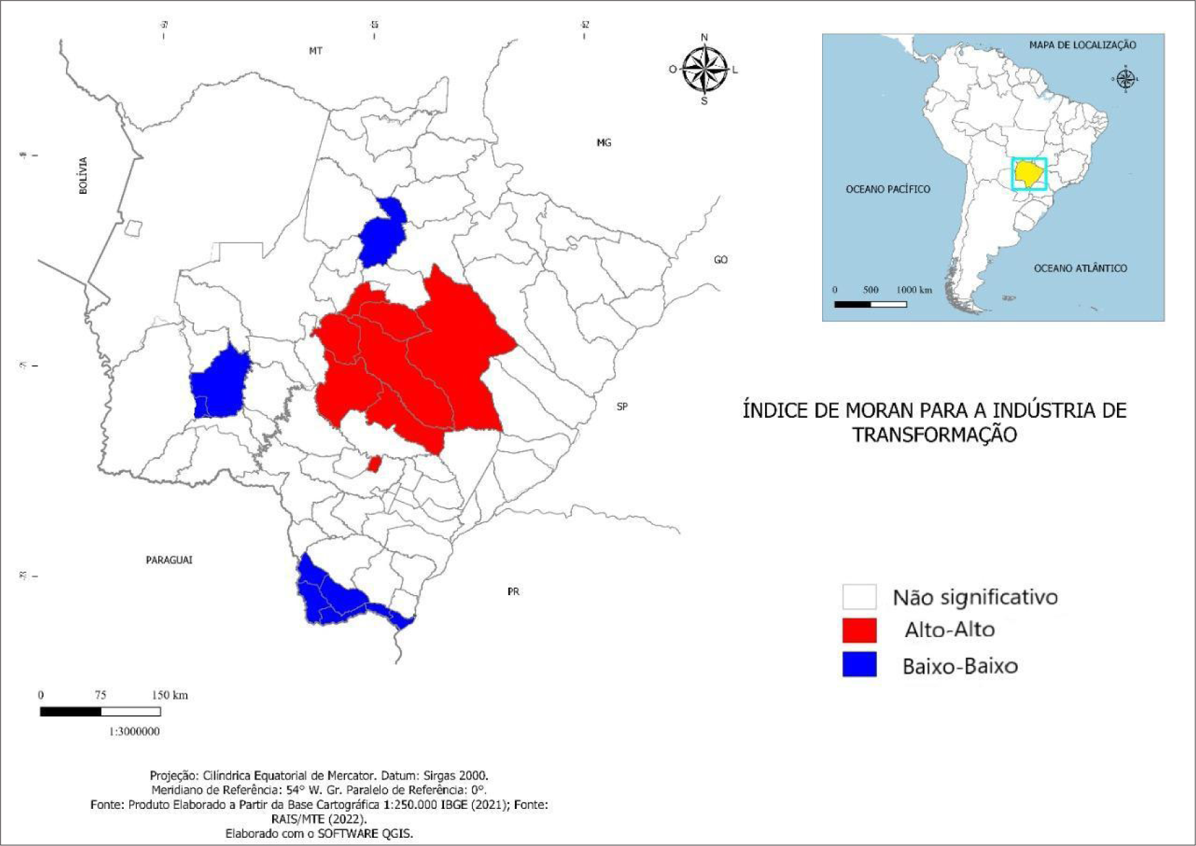
Analyzing the manufacturing industry, it can be pointed out that there is a spatial productive specialization in the municipalities of Campo Grande, Dourados, Jaraguari, Sidrolândia, Douradina, Itaporã, Nova Alvorada do Sul, Ponta Porã, Ribas do Rio Pardo, Rochedo, Terenos, and Três Lagoas, as evidenced in Map 4. In this sense, it is possible to observe that the greatest industrial specialization occurs in the center (influenced by Campo Grande) and in the east of the state, where some municipalities have their productive activities strongly associated with agriculture, and can be characterized as municipalities that produce inputs and have available labor.

This type of industry, related to agribusiness and natural resources, tends to locate its production plants based on the distance from raw materials and primary resources. Furthermore, another important characteristic is that the sector needs to guarantee a minimum volume of inputs to sustain production, which is also a decisive factor in plant allocation. In this sense, the municipalities of Três Lagoas, Ribas do Rio Pardo, and Nova Alvorada do Sul can be cited as examples of excellent industrial activities in the production of forest-based products, wood, and furniture, with their production base close to raw materials. This industrial complex linked to cellulose production is recent, and among the reasons for its attraction to Mato Grosso do Sul were considered logistical elements and tax incentives.
Another highlight related to the manufacturing industry is the clothing production activity, concentrated in the textile, footwear, and leather sectors in the municipalities of Campo Grande, Dourados, Douradina, and Três Lagoas. These segments typically allocate their plants based on the availability of low-wage, low-skilled, and paid labor. Therefore, the search for labor can be a factor that generates this relocation, or even tax incentive policies and subsidies that guarantee price competitiveness for these industries.
In line with this verification, Map 4 presents the Local Moran's Index for the Manufacturing Industry. The analysis of this indicator demonstrates the significant presence of the manufacturing industry in Campo Grande and its surrounding area. The analyses developed so far indicate that the region around the state capital has the potential to become a logistics hub due to its strategic location within the state of Mato Grosso do Sul and in Latin America.

Regarding the analysis of the third sector selected in this research, linked to the commercial sector, a spatial analysis of the spatially weighted productive specialization index of Commerce, Repair of Motor Vehicles and Motorcycles was carried out, as presented in Map 6. In this section of the CNAE/IBGE, the municipalities with specialization categorized as "high" are: Campo Grande, Dourados, Jaraguari, Nova Alvorada do Sul, Rochedo, Sidrolândia, Terenos, Caarapó, Cassilândia, Chapadão do Sul, Corumbá, Coxim, Deodápolis, Douradina, Fátima do Sul, Itaporã, Ladário, Laguna Carapã, Maracaju, Naviraí, Nova Andradina, Paranaíba, Ponta Porã, Ribas do Rio Pardo, Rio Brilhante, Selvíria, and Três Lagoas.

Spatially weighted productive specialization index of the Trade, Repair of Motor Vehicles and Motorcycles sector.
The analysis of the Local Moran's Index for the Trade, Repair of Motor Vehicles and Motorcycles section, presented in Map 7, shows that the municipalities classified in the "High-High" category for specialization were Campo Grande, Douradina, Jaraguari, Nova Alvorada do Sul, Ribas do Rio Pardo, Rochedo, Sidrolândia, and Terenos.

Therefore, Campo Grande stands out in all analyses of productive specialization in the state of Mato Grosso do Sul. On the one hand, it is important to take advantage of these gains from the agglomeration economies of the state capital; on the other hand, public development and territorial planning strategies are necessary. Policies should help ensure that the state of Mato Grosso do Sul has the largest possible number of municipalities benefiting from the route, so that the benefits are not concentrated only in municipalities that already have a high spatial distribution.
Furthermore, an important consideration concerns how to establish strategies to attract sectors that can complement the already established production network, especially. In this context, expansion into areas such as renewable energy, technology production for agribusiness and industry, and even maquiladoras or assembly plants for cargo vehicles, as well as parts and accessories for these, can be considered a strategy for diversification and productive complementarity.
3.2 Development potential for small businesses
Considering the productive specialization highlighted previously, it was noted that most of the productive clusters in Mato Grosso do Sul are located within the sectors highlighted in the analysis of this report: 1) Agriculture, Livestock, Forestry Production, Fishing and Aquaculture; 2) Manufacturing Industries; and 3) Trade, Repair of Motor Vehicles and Motorcycles. It is important to emphasize the role of small and medium-sized enterprises in these economic activities, highlighting the main results from the data analysis for the state of Mato Grosso do Sul.
As can be seen, employment relationships are concentrated mainly in small and medium-sized enterprises (SMEs) in the state of Mato Grosso do Sul. In general, across all economic activities, 59.75% of employment relationships are associated with SMEs with fewer than 250 employees. This result alone indicates the importance of small businesses to the state's productive structure. Furthermore, it should be noted that SMEs accounted for 99.60% of companies in Mato Grosso do Sul in 2020.
A similar situation is observed in the commerce sector. In this section of the CNAE (National Classification of Economic Activities), out of a total of 126,529 employment relationships in 2020, 38.22% (or 48,359) were generated in micro-enterprises. Small and medium-sized enterprises (those with fewer than 250 employees), in general, account for 97.86% of employment relationships.
When considering the manufacturing industry, the scenario is different. The number of large companies (those with more than 250 employees) is relatively more significant than in Mato Grosso do Sul's overall economic activity. Large companies account for 2.32% of the total number of companies in the state's manufacturing industry (73 companies out of a total of 3,153).
In the state's agricultural sector, the significant employment associated with livestock farming (6.13%) and temporary crop production (2.64%) stands out. Regarding the manufacturing industry, slaughtering and meat product production (5.13%) are noteworthy. In the commercial sector, activities classified as non-specialized retail trade (4.07%) deserve mention, with the emphasis that retail trade, in general, is prominent in terms of relative value in Mato Grosso do Sul.
4 FINAL CONSIDERATIONS
RILA refers to an international road transport corridor currently under implementation that will connect the state of Mato Grosso do Sul to the ports of northern Chile. This study aimed to analyze the productive clusters of Mato Grosso do Sul, highlighting the expected effects of RILA on their development. To this end, the state's productive clusters were mapped, disaggregating them by economic sector and enterprise size.
Key findings highlight the centrality of the state capital, Campo Grande, in all analyses of productive specialization for Mato Grosso do Sul. This underscores the potential economic gains from the capital's agglomeration, making it important for public planners to explore these gains during the implementation phase of the RILA (Integrated Logistics and Industrial Recovery Plan).
The municipalities of Três Lagoas, Ribas do Rio Pardo, Água Clara, and others in the eastern region of Mato Grosso do Sul also have great potential to benefit from the RILA (Integrated Coastal Region of Mato Grosso do Sul), especially when considering the productive sectors related to agriculture, forestry, and pulp production. A similar situation should be highlighted for municipalities such as Guia Lopes da Laguna and Jardim, which can benefit from spillover effects, especially for the meatpacking and food processing industries, a sector of great relative importance for the state of Mato Grosso do Sul. Porto Murtinho, on the border with Paraguay, may also have significant locational advantages in food production and meat processing.
Finally, the importance of small businesses for Mato Grosso do Sul is highlighted. Employment is concentrated mainly in SMEs in the state (59.75%), and these companies accounted for 99.60% of businesses in the state in 2020. Thus, with the establishment of Rila, it is expected that there will be a linkage of industrial activities, which can benefit small businesses.
5
Data availability
The entire dataset supporting the results of this study has been published in the article itself.
References
- ANSELIN, L. Spatial econometrics: methods and models. Kluwer Academic, Boston. 1988.
- ASATO, T. A.; MARQUES, H. R.; BUZARQUIS, R. M.; BORGES, P. P. Perspectivas da economia criativa e do desenvolvimento local no Corredor Bioceânico. Interações, Campo Grande, MS, v. 20, n. 1, p. 193–210, 2019.
- BASSO, D.; SILVA NETO, B.; STOFFEL, J. Concentração e especialização em setores industriais na Região Noroeste Colonial do Rio Grande do Sul. Indicadores Econômicos FEE, Porto Alegre, v. 33, n. 3, p. 163–74, dez. 2005.
- CAPELLO, R. Regional economics 2. ed. Oxon-UK: Routledge, 2016.
- FERREIRA, C. M. C. Espaço, regiões e economia regional. In: Haddad, P. R. (Org.). Economia regional, teorias e métodos de análise Fortaleza: BNB Etene, 1989. p. 46–66. [Cap. 1].
- GOVERNA, F.; SALONE, C. Territories in action, territories for action: the territorial dimension of Italian local development policies. International Journal of Urban and Regional Research, Estados Unidos, v. 28, n. 4, 796–818, 2004.
- HOOVER, E. Location theory and the shoe and leather industries. Cambridge-MA: Harvard University Press, 1970.
-
INSTITUTO BRASILEIRO DE GEOGRAFIA E ESTATÍSTICA [IBGE]. Áreas territoriais 2021 Rio de Janeiro, 2022. Disponível em: https://www.ibge.gov.br/geociencias/organizacao-do-territorio/estrutura-territorial/15761-areas-dos-municipios.html?t=acesso-ao-produto
» https://www.ibge.gov.br/geociencias/organizacao-do-territorio/estrutura-territorial/15761-areas-dos-municipios.html?t=acesso-ao-produto - ISARD, W. (1960) Methods of Regional Analysis. Cambridge: MIT Press.
- LOPES, A. S. Desenvolvimento Regional – problemática, teoria, modelos. Lisboa: Fundação Cabouste Gulbenkian, 2001.
- MYRDAL, G. Economic Theory and Underdeveloped Regions London: Gerald Duckworth, 1957.
-
MINISTÉRIO DO TRABALHO E EMPREGO [MTE]. Relação Anual de Informações Sociais [RAIS]. Brasília-DF, 2022. Disponível em: http://pdet.mte.gov.br/microdados-rais-e-caged Acesso em: 22 abr. 2022.
» http://pdet.mte.gov.br/microdados-rais-e-caged - MORAN, Patrick A. P. The interpretation of statistical maps. Journal of the Royal Statistical Society: Series B (Methodological), [s.l], v. 10, n. 2, p. 243–51, 1948.
- RICHARDSON, H. M. Economia Regional: teoria da localização, estrutura urbana e crescimento regional. Tradução de Cupertino. Rio de Janeiro: Zahar. 1975.
-
SECRETARIA DE ESTADO DE MEIO AMBIENTE, DESENVOLVIMENTO ECONÔMICO, PRODUÇÃO E AGRICULTURA FAMILIAR [SEMAGRO]. Maior exportador de celulose do país, MS vê setor florestal impulsionar economia verde no Estado. Mato Grosso do Sul. Competitividade, Silvicultura. Portal Semagro, Campo Grande, MS, out. 2020. Disponível: https://www.semagro.ms.gov.br/maior-exportador-de-celulose-do-pais-ms-ve-setor-florestal-impulsionar-economia-verde-no-estado/ Acesso em: ago. 2022.
» https://www.semagro.ms.gov.br/maior-exportador-de-celulose-do-pais-ms-ve-setor-florestal-impulsionar-economia-verde-no-estado/ - SOUZA, N. J. Economia regional: conceito e fundamentos teóricos. Perspectiva Econômica, Universidade do Vale do Rio dos Sinos, ano XVI, v. 11, n. 32, p. 67–102, 1981.

 Source: Prepared by the author based on
  Source: Prepared by the author based on Rais/MTE (
 Source: Prepared by the author based on Rais/MTE (
 Source: Prepared by the author based on Rais/MTE (
 Source: Prepared by the author based on Rais/MTE (
 Source: Prepared by the author based on Rais/MTE (
 Source: Prepared by the author based on Rais/MTE (