
 Expansion of past logics in the socio-spatial production: the Rodoanel Project in the Metropolitan Region of Belo Horizonte City, Brazil
Abstract
In a debate about the Beltway Road Project in the Metropolitan Region of the City of Belo Horizonte, Brazil, this paper aims to discuss how this project restructures this territory by reproducing some practices from the past, through investment in roads, induction of speculative processes, applying stress to sensitive environmental areas, and establishing new precarious and peripheral neighbourhoods. Methodologically, the survey and analysis discuss a logic of development that induces vehicular flows and processes of subdivision, occupation, and use of urban land. This study considered distinct versions of the Beltway Road Project since the 1970s. Despite the intention to solve some traffic congestion, the Beltway Project seems incapable of effectively modifying the radial structuration of the main highways of the Metropolitan Region of Belo Horizonte City, Brazil.
Keywords:
territorial restructuring; production of metropolitan space; logic of development; road modal
Resumo
Em um debate sobre o projeto do Rodoanel da Região Metropolitana de Belo Horizonte, este trabalho tem como objetivo investigar como tal proposta tende a reestruturar este território através da reprodução de lógicas pretéritas, dadas através de investimentos predominantes no modal rodoviário, da indução de processos imobiliários especulativos, do tensionamento de áreas ambientalmente sensíveis e da potencialização de parcelamentos periféricos e precários no entorno da via. Metodologicamente, os levantamentos e análises focaram-se no modo como projetos de infraestrutura rodoviária têm sido regidos pela aqui denominada lógica desenvolvimentista, indutora de fluxos e processos de parcelamento, ocupação e uso do solo urbanos. A estruturação viária da RMBH foi então estudada, desdobrando-se sobre diferentes versões do projeto do Rodoanel, da década de 1970 ao momento atual. Apesar de propor soluções para determinados conflitos viários, entende-se que tal via ainda é incapaz de modificar, efetivamente, a estruturação rodoviária predominantemente radial da RMBH.
Palavras-chave:
reestruturação territorial; produção do espaço metropolitano; lógica desenvolvimentista; modal rodoviário
Resumen
En un debate sobre el proyecto beltway en la Región Metropolitana de Belo Horizonte, Brasil, este trabajo tiene como objetivo investigar tendencias de reestructuración territorial a través de la reproducción de lógicas pasadas, con inversiones predominantes en el modal vial, procesos especulativos inmobiliarios, tensiones en zonas ambientalmente sensibles y aumento de fraccionamientos periféricos y precarios alrededor de la vía. Metodológicamente, los levantamientos y análisis se centraron en la forma en que los proyectos de infraestructura vial se han regido por una lógica de desarrollo que induce flujos y procesos de subdivisión, ocupación y uso del suelo urbano. Luego se estudió la estructura vial de la RMBH, bien como diferentes versiones del proyecto, desde la década de 1970 hasta la actualidad. A pesar de proponer soluciones para ciertos conflictos viales, se entiende que dicha ruta aún no es capaz de modificar efectivamente la estructura vial predominantemente radial de la RMBH.
Palabras clave:
reestructuración territorial; producción del espacio metropolitano; lógica del desarrollo; modal por carretera
Introduction
The space socially produced throughout the 20th century, forming the current territory of the Belo Horizonte metropolitan region, has among its features the opening of large highways as elements that induce processes of subdivision and occupation and use of urban land. It can be said that this logic applies to the contemporary production of space itself, especially in peripheral contexts such as Brazil. In the case of Belo Horizonte, since the implementation of the urban core circumscribed by Contorno Avenue, the main interventions, especially those of a regional nature, have featured the introduction of new processes.
These regional axes are generally characterized by radial logic, articulations between the urban core of Contorno Avenue and other territorial portions or highways, located to the north, east, south and west. Historically, the production of space in Belo Horizonte has been carried out in such a way as to direct the main flows to the urban core of the capital. Even when the ongoing process involved a new centrality, as in the case of the implementation of the Juventino Dias Industrial City in Contagem, or in the construction of the Pampulha Architectural Complex (both built in the 1940s), there was always a determination to promote direct connections with the center of Belo Horizonte (FJP, 1997).
The construction of the beltway in the 1950s (CMBH, 2021) was a first attempt to form an arching perimeter road in Belo Horizonte. At that time, the growing flow of freight from federal highways had to travel through the centre of the state. According to the CMBH (2021), the recurrence of traffic congestion, associated with the growth of industrial activities in the southwest (Barreiro region, in Belo Horizonte) and west (in the neighboring municipality of Contagem), led to the construction of a perimeter road loop with the purpose of articulating flows of the then named highways BR-3 and BR-7 (currently BR-040), BR-55 (currently BR-381) and BR-31 (currently BR-262).
In the 1970s, the João Pinheiro Foundation, responsible for the Planning of the Metropolitan Region of Belo Horizonte (PLAMBEL), prepared a study called the Metropolitan Structural Scheme. Six proposals were presented in this plan, among which the so-called alternative 1, related to the metropolitan road system (FJP, 1974). There was a proposal for a perimeter arch to complement the beltway, which was already showing signs of saturation. This proposal was not implemented at that time. Starting in 2007, the State Government of Minas Gerais proposed the construction of a bypass highway for the northern portion of the RMBH, complemented in 2018 by a loop that would also establish a connection to the south (Minas Gerais, 2021b). A significant similarity can be seen between the current route and that which emerged in the 1970s.
In view of this, the general objective of this work is to seek to understand the RMBH Beltway Project as an element of metropolitan restructuring. In addition, it is proposed to verify to what extent the current version of this project reproduces a set of past logics, with trends of traffic congestion, processes of real estate speculation and the induction of precarious urban land subdivisions. As an unfolding of these objectives, the aim is to map the process of road structuring of the current territory of RMBH, especially from the 1940s to the present day. In the context of spatial production, we seek to understand how the metropolitan territory has been structured and restructured through its large-scale road infrastructures, forming centralities and a set of adverse effects in peripheral areas. This approach is justified as a critical analysis of certain solutions, generally based on successive extensions of the road model, which have given rise to costly processes with limited returns from a socio-spatial point of view.
In conceptual terms, the debates held here are supported by contributions from Marx (2010) about the production of fixed and circulating capital, applied to the implementation of road infrastructures (a type of fixed capital installed in a given territory). Considering the space socially produced under the capitalist mode of production, such debates have unfolded around the set of contradictions linked to the implementation of large-scale road structures, in a dialogue with Lefebvre's (2012) theories of space production. This framework is linked to the so-called developmental logic (Bielschowsky, 2004; Lessa, 1998), in which the prevalence of the idea of economic development over a broad set of socio-spatial variables has led to the permanence or even the accentuation of contradictions linked to the historical processes of the RMBH. Methodologically, the theoretical and conceptual framework outlined above unfolds into a series of mappings, originating from georeferenced bases at the national (Brasil, 2019; IBGE, 2017), state (FJP, 1974, 1997) and regional (PDDI-RMBH, 2014) levels. The analyses aim to understand the historical process of road structuring in the RMBH territory, whose current version of the beltway project can enhance centralities, flows and adverse effects in peripheral areas.
Developmental logic and road infrastructure projects
This topic is based on two dialectically articulated contextualizations. The first, connected to the Brazilian context, considers the historical process of production of the national territory, whose insertion into capitalism has occurred until now in a peripheral or semi-peripheral manner. From this perspective, Brazil predominantly produces and reproduces itself through the overexploitation of natural resources and the labor force. This is complemented by concentrations of wealth and populations, associated with socio-spatial inequalities and historical processes of exclusion. This configuration has repercussions for the paradigm of Brazilian development, established between conditions (due to its non-central role in the capitalist system) and something that is continually sought (not yet achieved in a minimally balanced manner on a national scale).
A second contextualization, linked to the previous one, refers to the role of infrastructure in establishing development cycles. From the perspective of the production of goods in space, it is the infrastructures that enable access to the fundamental elements of such processes (inputs, labor force, consumer centers, among others).
For Schmid (2012), based on Lefebvre (2012), it is necessary to understand the paradigm shift that took place throughout the 20th century, in which the frontier of capitalist accumulation ceased to focus on the production of goods in space and began to focus on the production of space itself. It is worth considering here the strategic role of the road transport system in the circulation of capital, especially throughout the 20th century, with strong repercussions for the Brazilian context. Applied to the production of territory on a national scale and with the state as a fundamental structure, Lefebvre (2009, p. 224) addresses a “physical space, mapped, modified, transformed by the networks, circuits and flows established within it - highways, canals, railways, commercial and financial circuits, motorways and air routes, among others”.
Related to these debates, we discuss here how road infrastructures structure the territory in their implementation and operation processes. By enabling diverse flows, these highways enhance production processes and urban nucleations directly or indirectly linked to these axes. In the context of the beltway project of the RMBH, although it is constituted by a regional metropolitan road, this axis intersects with a series of federal highways. This establishes an analysis that dialogues with multiple geographic scales, since the improvement of traffic conditions in the RMBH can intensify or modify these flows.
In view of this contextualization, the concept of developmentalism is rescued here, and the so-called developmental logic, which permeates the implementation of Brazilian road axes, from the national to the local scale, is discussed. The road structuring discussed here is understood as part of a set of urban processes, from the perspective established by Lefebvre (2008). In addition to articulating the main metropolitan regions of Brazil, these structures are urbanistically designed and give rise to transformations that are progressively governed by typically urban logics.
As for the concept of developmentalism, Bielschowsky (2004) defines it from a technical, political and ideological perspective, whose application to Brazilian society occurs through an economic development project in which industrialization should be addressed as a fundamental guideline. Under the developmental paradigm, the author outlines that this industrialization would not be achieved through the free action of the market, and that the state should play a central role. The expansion of economic sectors would also be planned, as well as the instruments that would promote such expansion. Financial resources, aimed at both industrialization and its consequent expansion, would be organized by state agencies, responsible for the processes of fundraising, guidance and allocation. In this developmental project, it was foreseen that the state would invest directly in sectors in which private capital proved insufficient (Bielschowsky, 2004).
Lessa (1998, p. 50) adds a specific adjective to the term, defining it as a “national developmentalist project”. Anchored in actions dating back to the 1930s, this project was structured in a more systematic way in the 1950s, with important developments in the National Development Plans (PND) of the 1970s, especially the II PND, launched in 1974. This leads to a time frame regarding the establishment of the logic discussed here, as well as its subsequent practices and revisions.
While both Lessa (1998) and Bielschowsky (2004) anchor this process in the period mentioned above, it is worth considering the country's historical positioning throughout history, which, at least from the mid-19th century onwards, was caused by a set of hegemonic impositions based on insertion into the capitalist system and the construction of a modern nation-state. Added to this is Brazil's peripheral insertion in this system, which has led to the maintenance of cycles of exclusion, low average valorization of the workforce and processes of overexploitation of natural resources.
Castells (1977) emphasizes that logics such as those mentioned above, when applied to peripheral contexts, tend to generate distorted economic relations between countries. This is due, among other issues, to the relevance of industrialization within the developmental paradigm. Such processes unfolded in Brazil in import substitution policies, based on ECLAC precepts that, in general terms, resulted in the attraction of foreign industrial capital.
From this perspective, it is important to discuss how the road modal occupied a strategic role, with repercussions on both the production and circulation of goods, as well as on the production of Brazilian territory.
Rangel (1986) points out that this process occurred in a less intentional manner than indicated by a first reading. According to the author, the then incipient nature of Brazilian planning would not be capable of allowing such determinism, managing, at best, to be guided by the management of a set of trends. The railway system, at that time, was composed of several lines operated by different companies, with a regional reach. As the industrialization of the development project demanded a minimally unified market nationally, Rangel (1986) considers that the little or absent articulation between the railways that existed at the time would compromise this purpose. According to the author, road transport proved to be more suitable for breaking down regional isolation, promoting a door-to-door circulation system, which was then unfeasible for the railway system or for coastal navigation.
Regarding the process of establishing the automobile industry in Brazil, Latini (2007) points out how smaller industrial units, such as Ford, established in 1919, and General Motors, established in 1925, initially located in the city of São Paulo, were joined by other production and assembly units in the following decades. Among these, the author mentions the establishment of the Studebaker Automobile Distributor in 1945 (later expanded and renamed Vemag Veículos e Máquinas Agrícolas S.A.) and the Fábrica Nacional de Motores (FNM) in 1949. Arbix (2000) emphasizes that this replacement policy contributed to the development of industries based in Brazil, linked, among others, to the production of auto parts. The installation of the Companhia Siderúrgica Nacional (CSN-Brazil) in 1941, in Volta Redonda, Rio de Janeiro, by considerably expanding the production of flat steel, boosted the production of metal automobile parts on a large scale in the country (ANFAVEA, 2023).
In a review of the so-called triple alliance discussed by Evans (1980), it is highlighted how the consumer goods industry remained predominantly tied to foreign capital (with production units installed in the country), while the basic industry was driven by the state (directly or through partnerships between international and state-owned companies). Understanding the role of national capital in this triple alliance, as discussed by Evans (1980), it is highlighted that the execution of infrastructure works, although conducted, financed and operated by the state, had a significant presence of Brazilian companies throughout the 20th century.
Latini (2007) considers that the national plan to stimulate automobile production and the gradual implementation of the automobile industry, supported by Getúlio Vargas in 1952, was an institutional milestone for the sector in Brazil. For the author, this set of actions was strengthened from 1956 onwards, with the publication of the Plan of Goals. In goal 27 of this plan, the production of 170,000 nationalized vehicles by 1960 was proposed (Latini, 2007). Politically, such actions led to the publication of Decrees No. 39,412/1956, aimed at creating a Brazilian automobile industry, and No. 41,018/1957, which established the National Automobile Industry Plan. Among other guidelines, the 1957 Decree provided that in 1960, passenger cars sold in the country should have at least 95% of their parts produced nationally (Câmara dos Deputados, 1956, 1957).
According to the Institute of Applied Economic Research - IPEA (2010), the consequences of this process became more visible after the 1960s and 1970s, when the paved federal road network was considerably expanded. In 1960, there were 8,675 km of paved federal roads, while in 1980 this number was 47,487 km. In the following decades, this growth continued, although at a slower pace, and in 2000, the number was 56,097 km (IPEA, 2010).
The state's role is visible through the resources allocated to the expansion of the national road network, previously made possible through taxes on fuels and lubricants, as well as on vehicle ownership (IPEA, 2010). Added to this is a set of guidelines contained in the National Highway Plan, which encouraged states and municipalities to expand or build highways managed by their respective jurisdictions (IPEA, 2010). Brazilian freight transportation was increasingly supported by the roads, reaching 70% of general freight transported in the country in 2010 (IPEA, 2010). Regarding the number of vehicles registered in Brazil, this number continues to grow. According to data from IBGE (2023b), total Brazilian vehicles corresponded to 45,029,257 units in 2006, considering all types of automotive vehicles. In 2022, there were a total of 115,116,532 units, a growth of around 155% in 16 years.
There is still a criticism to be contextualized, brought by Norton (2021), which enables a dialogue between the reproduction and expansion of past logics related to the road model. According to the author, the global automobile industry has directed its efforts towards the progressive addition of technologies that, primarily, have intensified dependence on roads. From this perspective, Norton (2021) considers that the effective solution to problems related to circulation would be in the background. From the point of view of the reproduction of certain logics, the increase in vehicles leads to the construction of increasing road infrastructure. The expansion of these logics, when considering the technological increase in the road transport over time, would be linked to the tendency to intensify relations of dependence and concentration of capital.
In Brazil, the aim established between the 1930s and 1970s was to promote development through industrialization, and the road modal, for different reasons and conditions, became the main means of transport in the country. These technological innovations present themselves as external resources that, over time, have been progressively installed in Brazil, transforming and expanding past cycles. In the context of the beltway project of the RMBH, discussion here will address how such issues, established nationally, generated repercussions on multiple geographic scales and, as a consequence, structured and produced the metropolitan territory.
Road structure of the RMBH territory and origins of the beltway project
Debates related to the structuring of metropolitan space, considering the road mode, its infrastructures and flows, demand articulation between development and territory. For Brandão (2012), between the global and the local there is a series of scales, whose technical and political relations are crucial for the establishment of diverse territorial configurations. The author argues that approaches linked to urban processes should have remained at the core of debates on the political economy of development. In the context established here, it is highlighted that the national-developmentalist logic has historically had repercussions on the road infrastructure of the RMBH.
Brandão (2012) emphasizes that the hierarchy of the territory occurs through exogenous factors that unfold in technical and political decisions adopted over time (here focused on the beltway project of the RMBH). The author highlights that these determinations are the result of tensions and consensus in the socially produced space. Among these, the role of the road transport system in the construction of a circulation system at a national level is once again highlighted, marked by heterogeneities, incompleteness and discontinuities that permeate the multiple territorial scales of Brazil.
In a section on metropolitan contexts, Singer (1985) dedicates himself to investigating the economic role of the metropolitan scale on the inter-regional division of labor. If observed from a national scale, connections between capitals and between such centers and other municipalities play a decisive role. The population and urban growth of these capitals, which led to the formation and establishment of metropolitan areas, gives rise to the inter-regional divisions discussed by Singer (1985). In addition to housing the main state structures of their respective states, metropolitan centers concentrate populations and flows, as well as commercial and financial functions of greater complexity.
Singer (1985), in a reading linked to the Brazilian context of the 1970s, highlights how the insertion of industries in the then newly formed Brazilian metropolitan regions was remarkable for that period. The author also points out the strategic nature of the insertion of wholesale businesses in these areas, both due to their proximity to consumer markets and the possibilities of distribution through their infrastructures. This is reflected in the current logistics hubs of large digital retail companies, often linked to global production structures (Yassu, 2022), primarily supported by road transport in the context of the RMBH.
The National Highway System, assigned to the federal government, has the road network as one of its subsystems. Federal highways can currently be implemented directly by the government, as well as through public-private partnerships, concessions, authorizations or leases with public or private organizations (Brasil, 2011). They are classified into five types, presented in Chart 1 below.
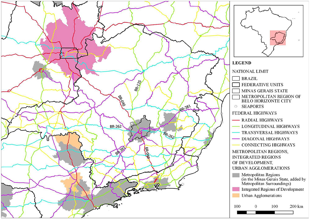
For the region under study, these road types are spatially displayed in Figure 1 below, showing how the main federal highways connect the RMBH to other parts of the territory of Minas Gerais and Brazil, with emphasis on connections with metropolitan regions, urban agglomerations and the Federal District.

Regarding the main flows established on the highways shown in Figure 1, information was sought from the RMBH Mobility Plan (Minas Gerais, 2019). Regarding road freight directed to this metropolitan territory, quantified by the number of trips throughout 2017, it was found that 35% of the total came from the State of São Paulo, followed by the states of the southern region of Brazil, 14%, and by the municipalities of the South/Southwest mesoregion of Minas Gerais, which corresponded to 6% of the total. Regarding the destinations of freight coming from the RMBH, the State of São Paulo and Zona da Mata each received 10% of the total trips, while the Vale do Rio Doce received 8% of the total in 2017 (Minas Gerais, 2019). Considering that the study cited above only covers flows originating or ending in the RMBH, we sought additional reading through Chart 2 below, which lists the federal highways connected to the RMBH.
Through Chart 2 above, when read in conjunction with Figure 1, it is possible to see that almost all federal highways have the RMBH as a route section. Only BR-135 has this region as its origin or destination, and it is worth noting that this highway is marked by interruptions and overlaps along its route, especially in the State of Bahia.
Related to the flow of people, considering the ten municipalities with the highest number of daily intra-municipal trips between 2019 and 2021, it was found that 71.11% of the total occurred within the territory of Belo Horizonte (Minas Gerais, 2021a). Among the ten main inter-municipal routes, it was identified that eight had Belo Horizonte as their origin or destination. Such issues reinforce the level of polarization of this centrality over the metropolitan territory.
Another pertinent aspect, constant in the georeferenced database of the National Department of Transport Infrastructure - DNITGEO (Brasil, 2019), refers to the identification of perimeter highways designed or implemented around dense urban areas. In the area analyzed in Figure 1, in addition to the RMBH beltway project, nine other perimeter roads were identified (Goiânia, Brasília, Montes Claros, Ipatinga, Governador Valadares, Vitória, Rio de Janeiro, Uberaba, Uberlândia), which are added to the São Paulo beltway, a state highway. This issue points to the fact that the implementation of perimeter roads constitutes a national guideline, related to the DNIT and, therefore, distinct from the stance of state governments in Minas Gerais, which, since 2008, have tried to present the RMBH beltway as their own initiative, predominantly linked to the state level.
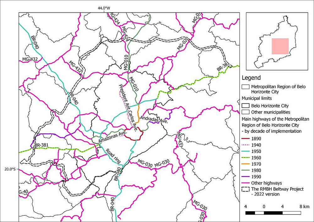
In a scalar approach, the main highways of the RMBH will be addressed below. This approach was made based on the established routes and the decades in which these infrastructures were implemented, seeking to understand the road structure of this territory over time. It is important to highlight that the mapped highways reached their current status during this time, since such access, on several occasions, was consolidated on old roads or local roads. The map resulting from these categorizations is presented in Figure 2 below.

The road infrastructure of the RMBH has as its starting point Contorno Avenue, a road with perimeter characteristics. With the construction of the new capital of the State of Minas Gerais, inaugurated in 1897, this road became the surrounding axis of the entire set of streets and avenues of the then urban area (FJP, 1997). From that moment on, road interventions carried out in Belo Horizonte and surrounding areas were predominantly radial in nature, directly connected to the limits of Contorno Avenue. Even when new centralities were built through direct state actions, as in the cases of Conjunto da Pampulha and Cidade Industrial Juventino Dias, which occurred in the 1940s and gave rise to the Avenues Presidente Antônio Carlos in the south-north direction, and Amazonas, in the east-west direction, the direct road connection with Contorno was present. This logic was reproduced in other road interventions carried out in the following decades.
The only exception occurred in the 1950s, when the Belo Horizonte beltway (CMBH, 2021) was implemented. The purpose of this axis was to reduce the effects of the growth in freight vehicle traffic in the central part of the city, an area that has historically received the main interstate and regional flows. Despite its perimeter characteristics, the total insertion of this road in Belo Horizonte generated conflicts due to the densification of the central-south, west, north and northeast parts of the capital. As a result, the beltway began to incorporate two types of vehicle flows simultaneously, linked to a typical federal highway and with freight flows and higher speeds, added to more concentrated intra-urban road flows. The result was the progressive occurrence of accidents and traffic congestion, the first signs of saturation of which date back to the 1970s (CMBH, 2021).
It is worth considering that the road structure of Belo Horizonte is the result of technical and political processes. On a regional scale, the strengthening of a central area led to the main flows being directed to that area. Associated with the construction of highways, it is of fundamental importance to consider that the main facilities, such as government buildings, hospitals, headquarters of public companies, among others, were confined to the limits of Contorno Avenue throughout the 20th century. This direction resulted in successive investment to develop the central area, progressively attracting private companies and consolidating higher-income residential patterns in certain neighborhoods within Contorno avenue.
The Integrated Development Plan for the RMBH, whose planning for the metropolitan region has been reviewed since 2008, indicated that the result of this structuring is a sprawling metropolitan territory, with highways directed to the main central area, which concentrates income and services and, consequently, generates situations of disparity in comparison with surrounding urban centers. In this sense, the PDDI-RMBH (2014) has highlighted the importance of establishing guidelines based on the production of a compact metropolis, with different modes of transportation and with perimeter road connections between centers of different levels, which would reduce dependence on the main metropolitan hub.
As for the origins of the beltway project, one of the first systematized records of such a proposal refers to the Metropolitan Structures Scheme, prepared by the planning body linked to the João Pinheiro Foundation. Initially published in 1974, this document was presented as one of the fundamental bases of the Metropolitan Planning of Belo Horizonte - PLAMBEL (FJP, 1974). This study was formulated under the projection that the RMBH would have a population of over 5 million inhabitants in 1990 (FJP, 1974). It is worth noting that this number was measured only in the 2022 Demographic Census (IBGE, 2023a).
This proposal outlined a guideline for the creation of a regional metropolis, based on the qualification of services and the installation of durable consumer goods industries, complementary to other industries (FJP, 1974). The establishment of a hierarchical network of centers, supported by an integrated transportation system, was also foreseen (FJP, 1974). Among other issues, this plan mentioned the implementation of high-capacity transportation systems, as well as intermodal, road and rail freight terminals. At that time, there was already recognition of the great concentration relative to the metropolitan centrality, located in Belo Horizonte. One of the alternatives to this scenario would be linked to the incentive to consolidate or strengthen secondary or local metropolitan subcenters.
Three alternatives were then developed in the Metropolitan Structures Scheme, one with a radial-concentric bias and again polarized from Belo Horizonte, and two proposals for the formation of perimeter-connected metropolitan subcenters. Regarding the transportation system, two proposals were presented, named as follows: network of centers and metropolitan highway system; and metropolitan rail system and mass transit (FJP, 1974). These proposals were divided into three alternatives, totaling six proposed studies. It is understood that alternative 1 of the metropolitan highway system, presented in Figure 3 below, contains significant similarities with the current version of the RMBH beltway project.

In alternative 01 above, the proposal for a large ring road (FJP, 1974) contains similarities with the current proposal in several points, such as the connection to the east with BR-381, to the north at the intersection between state highways MG-010 and MG-424, to the northwest with BR-040 and to the south with BR-040. This proposal, however, has not been consolidated to date, as well as none of the three proposals linked to the railway and high-capacity transport. On the other hand, the Metropolitan Structures Scheme mentions the future implementation of two routes then classified as priorities, north-south and east-west, which would combine “the use of the Arrudas Valley and the completion of the Cristiano Machado Avenue” (FJP, 1974, p. 88). The two axes are directly connected to the center of Belo Horizonte and, in this way, further reinforce the concentric radial structure established throughout the 20th century.
The reading carried out so far allows for an initial reflection on the reproduction of past logics in the structuring of the metropolitan territory, based on the prevalence of road projects to the detriment of the railways. In the context of the RMBH, this configuration has been aggravated by the decision to maintain the concentration of flows in a main centrality. It is possible to point out that only partial contradictions occurred in the first decade of the 2000s, with the implementation of the Administrative City of Minas Gerais and the resumption of large-scale flights at Confins International Airport. Despite being located on the northern axis of the RMBH, which meant a relative displacement in relation to the centrality of Belo Horizonte, the connections have occurred through highways, radially connected to the strategic urban centers of the capital of Minas Gerais.
The current version of the project and its role in restructuring the RMBH territory
The RMBH beltway project was resumed in 2007, in the midst of the metropolitan interventions led by the state government at the time. Since then, the project has had four main configurations, both in terms of routes and strategies for its feasibility. These configurations can also be understood as cycles, since they correspond to different government periods, established between 2006-2010; 2010-2014; 2014-2018; 2018-2022 - and from that period to the present day (Minas Gerais, 2023). Different models carried out culminate in the current subdivision into north, west, southwest and south loops. To date, there is still no firm proposal for what a hypothetical southeast loop would be. It is believed that the main reason is linked to geological constraints and possible technical and cost difficulties, in crossing the Gandarela and Caraça mountain ranges (areas of great environmental importance).
A common point in these proposals refers to the premise that the RMBH beltway would be made viable through concessions or partnerships with private companies. Such discussions are linked to the responsibilities of the state and potential private capital players in financing the planning, design, licensing, execution of works, operation and maintenance stages. With the payment of tolls throughout the operation as the main source, the advance contribution to be made by the state (generally to make the works viable) and the average price to be charged per stretch become crucial conditions. Given the progressively limited conditions of the Minas Gerais State Government to finance the design stages and, mainly, the construction works, combined with the reduction in investment by the federal government, which occurred, especially, from 2016 onwards, this issue became an obstacle that led to the beltway of the RMBH being practically paralyzed.
The reversal of this situation occurred through a process that was, to say the least, controversial. After the rupture of Dam 01 of mining waste at the Córrego do Feijão Mine, operated by the company Vale S.A. and which occurred in January 2019, an intense discussion about reparatory compensation was established in Minas Gerais. This process culminated in an agreement signed in February 2021, between Vale S.A. and the Minas Gerais State Government, in which a payment of around R$ 37.7 billion was provided to repair the damage. It was agreed at the time that R$26.7 billion of this amount would be managed directly by the company, while R$11 billion would be transferred to the state (ALMG, 2022). The management of these resources under state management was formalized through state law No. 23,830/2021, in which approximately R$3.5 billion was earmarked for the implementation of the beltway of the RMBH (ALMG, 2021).
In an analysis of this process, the socio-environmental impact stands out, which, among other issues, resulted in the death of 272 people and the contamination of approximately 300 kilometers of the Paraopeba river (ALMG, 2022). Among the remedial actions, financing was provided for a highway whose construction will enhance primarily economic aspects, linked to the circulation of freight on a regional and national scale.
It is worth considering that the construction of the beltway in the RMBH, by removing the flow of heavy vehicles from the Belo Horizonte beltway, has significantly reduced the number of fatal accidents on this road. This can be understood as a social and environmental benefit, made possible by the proposed road. On the other hand, there has been an increasing use of road transport for the transportation of minerals from the RMBH, the Iron Quadrangle and the surrounding areas, located on different roads such as BR-040, MG-020, among others. This leads to the discussion that the mining activity itself, which causes great socio-environmental damage, can directly benefit from compensation applied to mitigate the negative impact caused by it.
Relations between the state and municipal governments have not always been harmonious and have made up the set of institutional issues related to the beltway in its most recent versions. Although metropolitan planning is constitutionally attributed to the states, in the constitution itself, municipalities are responsible for their respective urban territorial orders (Brasil, 1988). Considering that to date the Master Plan for Integrated Development of the RMBH has not been approved by the state legislative assembly, there are a series of gaps regarding the application of metropolitan parameters at the municipal level, especially with regard to the beltway. This is mainly felt within the scope of the current city governments of Contagem and Betim, whose position against the project is locally justified by the potential negative impacts on their respective central areas, which would be split by the proposed highway, and on the pressure for new subdivisions around the Várzea das Flores reservoir, located on the border of the two municipalities.
In a debate on the reproduction of past logics, it is understood that the allocation of investment to new highways, to the detriment of railways, in itself, corresponds to the continuation of a model that is reproduced by the improvement in traffic conditions for automotive vehicles. This is a reproduction that is anchored in a specific type of space production, with limited scope. Another logic that is reproduced refers to the use of highway axes as inducers of urban land subdivision processes. This issue has a peculiarity in the process of implementing the beltway of the RMBH, since this road has a limited number of intersections with surrounding areas along its route. As a result, in the vicinity of the twelve planned road intersections, generally corresponding to intersections with existing federal and state highways, urban processes of greater intensity tend to occur, especially when compared to the other areas bordering the beltway.
Based on this, a map was created that seeks to qualify scenarios in terms of induction of urban land division and occupation and use processes based on the cross-referencing of data from the PDDI-RMBH (2014), the RMBH Mobility Plan (Minas Gerais, 2019), the Data Viva Platform (CEDEPLAR-UFMG, 2024), and the IBGE (2011). These spatializations are presented in Figure 4 below.

One aspect to be observed in Figure 4 refers to the delimitation of the polygons, and it is not yet possible to specify the temporality of these dynamics, nor continuities or discontinuities in terms of land subdivision. The analyses carried out here point to the establishment of informal processes of urban land subdivision, especially at the junction with BR-381, to the east, and with BR-040, to the northwest. According to Rolnik (2015), the classification of these processes as formal or informal is more comprehensive than the dichotomy between legal and illegal. Based on the author, the informal subdivisions discussed here correspond to those whose implementation or expansion have occurred without the direct presence of the state, both in the planning and implementation stages, as well as in the titling of buildings and land.
If we consider the presence of low-income occupation, marked by the lack of infrastructure and the low construction standards of the buildings, which have intensified since the 1990s in the areas surrounding federal highways in the municipalities of Ribeirão das Neves (BR-040), Sabará and Santa Luzia (BR-381), another past logic can be expanded and reproduced through the beltway of the RMBH. Any mitigation of such processes would be linked to the action of municipal governments, which has not occurred to date. In terms of formal subdivisions, with demands for licensing by state bodies, one of the areas of greatest tension is linked to the area surrounding the Várzea das Flores Reservoir. The possible building of a new highway, with a road intersection in the area, increases the demand for the implementation of middle and upper-middle-income residential subdivisions in this location.
Finally, a trend towards the implementation of logistics hubs in the northern, northwest, west and southwest boundaries was identified. Such patterns of occupation and land use make sense as the implementation of a metropolitan perimeter highway directs flows of consumer goods to an arc outside the main densely populated areas. As a result, such projects tend to enhance such connections, considering the implementation of the beltway in the RMBH.
Considerations and notes
The interpretations established here point to the formation of a metropolitan territory that still lacks actions capable of reversing a situation that predominantly reproduces a set of preexisting logics. On the one hand, the beltway of the RMBH forms a perimeter road axis, not directed to the center of Belo Horizonte, but on the other hand, this route does not contemplate a regional plan of occupation and land use, capable of coordinating the main territorial dynamics that tend to be established. In the current configuration, we see the intensification of speculative processes on a municipal scale and lacking greater coordination at the metropolitan level.
If we review the Metropolitan Structures Plan, drawn up in the 1970s, we see that this initiative contemplated other modes of transport, as well as the development of new centralities. Such a configuration has not occurred to date, which leads the current version of the beltway to present itself as yet another incomplete solution. It should be noted that the territory of the RMBH, created over the 20th and 21st centuries, by prioritizing radial connections with the centrality of Belo Horizonte, has shown a kind of fear of developing new centers, connected along the perimeter. In addition to being technical, it is understood that these decisions are also political, increasing real estate appreciation in certain parts of the territory and limiting the establishment of other cycles. Such debates require complementary studies that, in the future, can focus on more approximate geographic scales. This applies both to the area around Várzea das Flores, mentioned above, and to areas that are relevant from an ethnic and historical point of view, such as the area around the Cemitério dos Escravizados, located in the municipality of Santa Luzia. Another discussion applies to the development of studies on processes of speculation and real estate appreciation, in areas directly and indirectly connected to the beltway of the RMBH. Speculative dynamics refer, above all, to the strategic maintenance of undivided or unoccupied territorial portions, through expectations of substantial increases in land prices. The appreciation, in turn, is linked to the progressive addition of capital to the territory, in the process of social production of space. The scenarios outlined in the last topic of the work indicate areas with specific dynamics, to be taken as a basis for these subsequent readings.
REFERENCES
- ALMG. Assembleia Legislativa de Minas Gerais. Lei nº 23830, de 28/07/2021. Belo Horizonte: ALMG, 2021.
- ALMG. Assembleia Legislativa de Minas Gerais. Comissão vai discutir acordo com a Vale. Belo Horizonte: ALMG , 2022.
-
ANFAVEA. Associação Nacional dos Fabricantes de Veículos Automotores. Linha do Tempo. São Paulo: ANFAVEA, 2023. Available from: https://anfavea.com.br/site/historia-da-industria-automotiva/ Access at: 19 out. 2023.
» https://anfavea.com.br/site/historia-da-industria-automotiva/ - ARBIX, Glauco. Guerra Fiscal e Competição Intermunicipal por Novos Investimentos no Setor Automotivo Brasileiro. Revista de Ciências Sociais, Rio de Janeiro, v. 43, n. 1, p. 1-47, 2000.
- BIELSCHOWSKY, Ricardo. Pensamento Econômico Brasileiro: o ciclo ideológico do desenvolvimentismo. Rio de Janeiro: Contraponto, 2004.
- BRANDÃO, Carlos. Território e Desenvolvimento: as múltiplas escalas entre o local e o global. Campinas: Editora da Unicamp, 2012.
- BRASIL. República Federativa do Brasil. Constituição da República Federativa do Brasil de 1988. Brasília: Presidência da República, 1988.
- BRASIL. República Federativa do Brasil. Lei nº 12.379, de 6 de janeiro de 2011. Brasília: Presidência da República , 2011.
- BRASIL. Departamento Nacional de Infraestrutura de Transportes. DNITGEO - Geotecnologias Aplicadas. Brasília: DNIT, 2019.
- CÂMARA DOS DEPUTADOS. Decreto nº 39.412, de 16 de junho de 1956. Estabelece normas diretoras para a criação da Indústria Automobilística Brasileira e institui o Grupo Executivo para aplicação dessas normas. Brasília: Câmara dos Deputados, 1956.
- CÂMARA DOS DEPUTADOS. Decreto nº 41.018, de 26 de fevereiro de 1957. Institui o Plano Nacional da Indústria Automobilística relativo a automóveis da passageiros. Brasília: Câmara dos Deputados , 1957.
- CASTELLS, Manuel. The Urban Question: A Marxist Approach. Londres: Edward Arnold Publishers, 1977.
-
CEDEPLAR - UFMG. Centro de Desenvolvimento do Planejamento Regional da UFMG. Data Viva. Plataforma de Dados. Belo Horizonte: CEDEPLAR - UFMG, 2024. Available from: https://www.dataviva.info/pt/ Access at: 11 mar. 2024.
» https://www.dataviva.info/pt/ - CEM - USP. Centro de Estudos da Metrópole da USP. Base cartográfica digital em formato Shape das Regiões Metropolitanas, Aglomerações Urbanas e RIDE (Região Integrada de Desenvolvimento) brasileiros, totalizando 82 polígonos. São Paulo: Universidade de São Paulo, 2020.
- CMBH. Câmara Municipal de Belo Horizonte. Nota técnica nº 58/2021. Belo Horizonte: Diretoria do Processo Legislativo, Divisão de Consultoria Legislativa da CMBH, 2021.
- EVANS, Peter. A tríplice aliança: as multinacionais, as estatais e o capital nacional no desenvolvimento dependente brasileiro. Rio de Janeiro: Zahar, 1980.
- FJP . Fundação João Pinheiro. Esquema Metropolitano de Estruturas. Belo Horizonte: PLAMBEL - Fundação João Pinheiro, 1974.
- FJP . Fundação João Pinheiro. Panorama de Belo Horizonte, Atlas Histórico. Belo Horizonte: Centro de Estudos Históricos e Culturais da Fundação João Pinheiro, 1997.
- IBGE. Instituto Brasileiro de Geografia e Estatística. Censo Demográfico de 2010. Rio de Janeiro: IBGE, 2011.
- IBGE. Instituto Brasileiro de Geografia e Estatística. Base Cartográfica BC250 -Unidade da Federação - 1:250.000 - 2017. Rio de Janeiro: Diretoria de Geociências do IBGE, 2017.
- IBGE. Instituto Brasileiro de Geografia e Estatística. Censo Demográfico de 2022. Rio de Janeiro: IBGE , 2023a.
- IBGE. Instituto Brasileiro de Geografia e Estatística. Frota de veículos - anos 2006 a 2022. Rio de Janeiro: IBGE , 2023b.
- IPEA. Instituto de Pesquisa Econômica Aplicada. Rodovias brasileiras: gargalos, investimentos, concessões e preocupações com o futuro. Brasília: IPEA, 2010.
- LATINI, Sydney Alberto. A implantação da indústria automobilística no Brasil: da substituição de importações ativa à globalização passiva. São Paulo: Editora Alaúde, 2007.
- LEFEBVRE, Henri. A Revolução Urbana. Belo Horizonte: Editora da UFMG, 2008.
- LEFEBVRE, Henri. State, space, world: selected essays. Minneapolis: University of Minnesota Press, 2009.
- LEFEBVRE, Henri. The production of space. Malden: Blackwell Publishing, 2012.
- LESSA, Carlos. A estratégia de desenvolvimento - 1974 - 1976 - sonho e fracasso. Campinas: Editora da Unicamp , 1998.
- MARX, Karl. Capital - A Critique of Political Economy. Volume II: The Process of Circulation of Capital. Moscow: Progress Publishers, 2010.
- MINAS GERAIS. Secretaria de Estado de Infraestrutura e Mobilidade de Minas Gerais. Plano de mobilidade da Região Metropolitana de Belo Horizonte. Produto 14B: relatório da matriz origem e destino de cargas. Belo Horizonte: SEINFRA-MG, 2019.
- MINAS GERAIS. Agência de Desenvolvimento da RMBH. Relatório de metodologia e resultados OD RMBH - 2019 - 2021. Belo Horizonte: ARMBH, 2021a.
- MINAS GERAIS. Secretaria de Estado de Infraestrutura e Mobilidade de Minas Gerais. Rodoanel da Região Metropolitana de Belo Horizonte. Apresentação - Audiência Pública. Belo Horizonte: SEINFRA-MG , 2021b.
- MINAS GERAIS. Secretaria de Estado de Infraestrutura e Mobilidade de Minas Gerais. Traçado georreferenciado do Rodoanel da Região Metropolitana de Belo Horizonte. Versão 2022 . Belo Horizonte: SEINFRA-MG , 2023.
- NORTON, Peter. Autonorama: The Illusory Promise of High-Tech Driving. Washington: Island Press, 2021.
- PDDI-RMBH. Plano Diretor de Desenvolvimento Integrado da Região Metropolitana de Belo Horizonte. Macrozoneamento da Região Metropolitana de Belo Horizonte. Belo Horizonte: Governo do Estado de Minas Gerais; Universidade Federal de Minas Gerais, 2014.
- RANGEL, Ignácio de Mourão. Ferrovia x Rodovia. Revista Ferroviária, São Paulo, p. 43, 1986.
- ROLNIK, Raquel. Guerra dos lugares: a colonização da terra e da moradia na era das finanças. São Paulo: Boitempo, 2015.
- SCHMID, Christian. A teoria da produção do espaço de Henri Lefebvre: em direção a uma dialética tridimensional. GEOUSP - Espaço e Tempo, São Paulo, v. 16, n. 3, p. 89-109, 2012.
- SINGER, Paul. Economia política da urbanização. São Paulo: Editora Brasiliense, 1985.
- YASSU, Alexandre Mitsuro da Silveira. O galpão logístico e a financeirização urbana: da flexibilidade produtiva ao imobiliário. Cadernos Metrópole, São Paulo, v. 24, n. 53, p. 257-281, 2022.

 Source: Produced by the author from
  Source: Produced by the author from
  Source:
  Source: Produced by the author from