
 Urban parks and socio-spatial reconfiguration: the case of Parque do Povo, Toledo, Paraná
Abstract
Given the relevance of urban parks as drivers of socio-spatial reconfigurations, we examined transformations following the establishment of Parque do Povo Luiz Cláudio Hoffmann, in the city of Toledo, state of Paraná, Brazil, by comparing the 2010 and 2022 Brazilian Population Censuses. Based on five spatialized census indicators processed using GIS, we identified recent urban occupation patterns: rising construction standards, low residential density, and a high proportion of vacant dwellings. We demonstrate the analytical power of census data, even at the intra-urban scale, especially when combined with qualitative methods and institutional sources. The results reveal a selective restructuring of the urban fabric, guided by socioeconomic criteria, and reaffirm the importance of the census for critical urban research.
Keywords
population census; urban parks; socio- -spatial selectivity; urban space production; medium--sized cities
Resumo
À luz da relevância dos parques urbanos como vetores de reconfigurações socioespaciais, este artigo analisa as transformações associadas à implantação do Parque do Povo Luiz Cláudio Hoffmann, em Toledo (PR), por meio de comparação entre os Censos Demográficos de 2010 e 2022. Com base em cinco indicadores censitários espacializados em SIGs, identificam-se padrões recentes de ocupação: elevação do padrão construtivo, baixa densidade habitacional e alta proporção de domicílios desocupados. Demonstra-se a potência analítica dos dados censitários, mesmo em escala intraurbana, especialmente quando articulados a métodos qualitativos e fontes institucionais. Os resultados indicam reestruturação seletiva do tecido urbano, orientada por critérios socioeconômicos, e reforçam a importância do censo para a pesquisa urbana crítica.
Palavras-chave
censos demográficos; parques urbanos; seletividade socioespacial; produção do espaço urbano; cidades de porte médio
Introduction
The increasing demand for ecological and functional redevelopment in cities has prompted the integration of green spaces into urban planning. In this scenario, urban parks have assumed a prominent role, being perceived as vectors of landscape redevelopment, mechanisms for promoting sustainability, and elements that induce new centralities. However, despite their potential environmental and social benefits, the implementation of these strategies can lead to ambiguous impacts on urban organization, particularly concerning real estate overvaluation, reorganization of land use, and the exacerbation of socio-spatial segregation processes.
Recent studies indicate that urban parks are evolving beyond their conventional function as recreational and contemplative spaces to become catalysts for territorial reconfiguration and spatial differentiation. Research conducted by Immergluck and Balan (2018) and Baumgartner (2021) indicate that these parks, particularly when incorporated into discourses on sustainability and the 2030 Agenda, have been appropriated by real estate agents as symbolic assets that intensify the selective appreciation of urban land. However, extant research on this subject primarily focuses on metropolises and large urban centers, which does not reflect the reality of medium-sized cities, defined as those with a population between 50,000 and 500,000 inhabitants (Sposito, 2006).
Given the growing interest in this topic, it is important to conduct further research on the impact of implementing urban parks in intermediate urban contexts. This raises a fundamental question: which data sources and methodological processes are available to researchers to facilitate such analyses?
The integration of quantitative data from demographic censuses with Geographic Information System (GIS) analyses has emerged as a promising path for further research. These tools possess considerable potential for elucidating dynamics in small territories and at standardized time intervals. However, the articulation between these databases and spatial methodologies remains under-explored, which compromises a more comprehensive reading of the processes of urban transformation linked to the implementation of facilities such as parks.
Confronted with this challenge, this article proposes the use of census indicators to identify socio-spatial transformations, changes in occupation dynamics, and indications of selective appreciation in a quantifiable and substantial manner. We focus on a particular case study: the implementation of Parque do Povo Luiz Cláudio Hoffmann, situated in the northern region of Toledo, Paraná, Brazil. The research utilizes census data from 2010 and 2022, structured around five indicators: housing occupancy status, residential construction standards, population density, housing vacancy rate, and adult literacy rate. Accordingly, an integrated reading of the socio-spatial transformations in the study area is hereby proposed. From a broader perspective, the aim is to encourage future research that develops and applies specific indicators to analyze urban dynamics associated with the implementation of green infrastructure in cities.
Census data are a foundational source for urban analysis; however, their application becomes more consistent when integrated with other types of data and methodological procedures. In this article, we opted to utilize census data as the primary analytical framework to explore their capacity to elucidate the socio-spatial dynamics concomitant with the implementation of Parque do Povo.
The article is organized into five sections, in addition to this introduction. The second section establishes the research topic within a theoretical discussion on urban parks and selective appreciation of space. The third discusses the uses and limitations of census data in urban analysis, considering theoretical and methodological references. The fourth section of this study presents the indicators used, their corresponding variables, and the spatial representation procedures adopted. The fifth section implements an empirical analysis of the transformations in the surroundings of Parque do Povo, integrating census data and cartographic representation. The sixth section encompasses the final considerations, with an emphasis on the primary findings and a suggestion for future research directions.
Urban parks and selective appreciation
The case of Parque do Povo Luiz Cláudio Hoffmann in Toledo, along with the spatial transformations that occurred during and after its implementation, replicate characteristics that have been widely documented in the literature on urban green areas, and which have been observed in different geographical contexts. The establishment of urban parks, while potentially advantageous in terms of environmental and social benefits, frequently results in alterations to the immediate urban fabric. Such changes are often met with disapproval or regarded as detrimental by the residents of the affected areas.
The implementation of these parks is driven by strategic urban planning, rather than being the result of fortuitous actions. These areas are held in high esteem by the population due to their provision of numerous amenities and opportunities for utilization. From the perspective of municipal managers, these parks function as instruments of urban management, acting as rainwater percolationareas, for example, mitigating the risk of flooding. Additionally, they act as preserves of springs and as barriers to unplanned urban expansion, thereby articulating environmental conservation and the requalification of the urban fabric.
Accordin to Dianfeng Liu et al. (2023), the social and ecological functions provided by urban green areas are indispensable to the sustainability of cities. This includes the preservation of biodiversity and the provision of public recreational spaces. From an ecological perspective, these areas provide vital ecosystem services, including oxygen production, carbon sequestration, microclimate regulation through thermal and humidity control, the filtration of pollutants, and the conservation of water and soil. In certain contexts, they also contribute to urban access to fresh food. Socially, they promote leisure, contemplation, symbolic appreciation, environmental education, natural risk prevention, and the strengthening of residents’ connection to the urban landscape and public space (Lovell; Taylor, 2013; Immergluck; Balan, 2018).
However, an increase in the availability of urban green spaces frequently engenders unintended consequences, particularly regarding the land and real estate value of the surrounding area. In their analysis, Dan Immergluck and Tharunya Balan (2018) examined the Atlanta Beltline project, which involved the transformation of 35 km of former railway lines into a network of trails, parks, and affordable housing. The authors observed a significant increase in property values in the region, with increases ranging from 17.9% and 26.6%, benefiting higher-income groups. The absence of effective housing policies – including subsidies, rent control, and property tax regulation – has led to the exclusion of low-income residents, both tenants and small landlords. Despite the project’s initial provision for over 2,000 affordable housing units, the actual delivery of these units was less than half of the initial allocation, thereby exacerbating the pressure to displace vulnerable populations.
Wendel Henrique Baumgartner (2021) emphasizes that the creation of urban green spaces, even when justified by the discourse of sustainability and aligned with the 2030 Agenda, can be appropriated by real estate agents as a strategy for selective land valuation. Instead of facilitating increased access to nature and the city, the Sustainable Development Goals (SDGs) when converted into symbolic and marketable assets perpetuate socio-spatial inequalities. The case of Augusta Park in São Paulo is relevant in this context. Despite its genesis as a mobilization in defense of the right to the city and to environmental preservation, its inauguration was rapidly exploited by high-end developments, such as the Olhar Augusta building. The strategic positioning of the building was leveraged as a competitive advantage, enabling the establishment of prices that surpassed the local average. The process of valorization was facilitated by permissive urban planning regulations, which encouraged verticalization without imposing public countermeasures. Consequently, a collectively acquired green area was effectively converted into a market privilege.
As demonstrated in the extant literature, urban parks, despite their capacity to engender widely recognized environmental and social benefits, have the potential to function as vectors of socio-spatial differentiation and selective land appreciation, particularly when associated with market logic without the presence of control or inclusion mechanisms.
Therefore, the objective of this study is to analyze the transformations resulting from the implementation of Parque do Povo Luiz Cláudio Hoffmann in Toledo (PR). This analysis aims to highlight how these dynamics manifest themselves in the case studied and their effects on the spatial configuration of the immediate surroundings. In order to provide foundation for the construction of consistent indicators to measure the transformations associated with the implementation of urban parks, this section will discuss the data source used – the Demographic Censuses – as well as its uses and limitations.
Uses and limitations of census data
In the essay Importancia del Censo Nacional de Población de 2020 (Importance of the 2020 National Population Census), Hildebrando Araica (2018) posits that despite the emergence of supplementary databases, such as administrative records and sample surveys, the demographic census continues to stand as the most comprehensive and reliable source of demographic and socioeconomic information with a nation. This position is predicated on the methodological scope of the census and its capacity to produce diagnoses that inform urban and regional planning. For Araica, the implementation of effective public policies requires the availability of reliable estimates of population size and distribution, age structure, and growth and migration dynamics. The census provides this empirical basis by supporting the construction of indicators that are essential for the formulation of territorial development policies.
The universality of census coverage, which aims to reach all households, is a methodological advantage over other data sources that are more limited in scope and representativeness. The provision of standardized information at national, regional, and local levels is enabled by census data, thereby facilitating the identification of inequalities and a judicious allocation of public resources, including urban infrastructure, social facilities, and essential services (ibid.).
In their 2016 analysis of the utilization of IBGE (Brazilian Institute of Geography and Statistics) data in territorial planning, Pera and Bueno (2016) emphasize that the demographic census frequently serves as the sole reliable statistical foundation available in Brazilian municipalities, particularly in contexts characterized by institutional deficiencies and the absence of technical expertise. For the authors, census data function not only as mechanisms for population quantification but also as strategic tools for the design of urban policies capable of addressing social and spatial inequalities on an intra-urban scale.
In the production of knowledge about the city, Logan (2018), in his essay Relying on the Census in Urban Social Science, highlights the centrality of the census as a fundamental empirical tool for urban analysis. The author posits that census data possesses a unique analytical capacity due to its reliability and the possibility of accessing reduced territorial sections, such as census tracts. This combination of spatial granularity and temporal standardization facilitates the systematic investigation of urban transformations across different census periods.
However, Logan also identifies substantial limitations to the utilization of census data. For instance, he emphasizes the potential for confusion between census tracts, which are statistical units, and neighborhoods, which are more dense and heterogeneous sociocultural areas. A further issue arises from the utilization of sample data for analyses on small scales, a practice that has the potential to result in interpretive distortions, particularly when variations are interpreted as structural trends.
In addition to considerations regarding the territorial delimitation and the nature of the sample, Logan advocates for the integration of quantitative and qualitative methodologies in urban research. While censuses provide pertinent variables, including income, education, and housing conditions, they are limited in their capacity to capture the intricacies of social practices, symbolic representations, and relational dynamics that define urban life. To this end, it is necessary to employ ethnographic approaches, in-depth interviews, and direct observation, which can reveal aspects that elude quantification.
In this regard, the utilization of census data must be approached with a critical eye and in an integrated manner. When combined with spatial methodologies, such as GIS, censuses acquire greater explanatory potential, allowing the identification of patterns of inequality, processes of valorization, and transformations in land use. While they do not exhaust the complexity of urban reality, censuses remain an irreplaceable basis for its analysis, when interpreted with methodological rigor.
Census indicators and analysis planning
The objective of this research is to examine the changes that have occurred in the dynamics of occupation in the area surrounding Parque do Povo Luiz Cláudio Hoffmann. To this end, five census indicators have been defined. The selection was based on data from the 2010 and 2022 Demographic Censuses, using the criteria of intra-urban comparison and the relevance of the variables for identifying socio-spatial patterns. The indicators employed in this study encompassed various socio-economic factors, including housing occupancy status, residential construction standards, population density, housing vacancy rate, and adult literacy rate.
The selection of variables from the universe questionnaire (Basic Census File) guaranteed comprehensive coverage of the urban census tracts of Toledo (PR), circumventing the limitations associated with sample data, whose representativeness in small spatial areas is often compromised. As Logan (2018) cautions, the utilization of sample data in units such as census tracts can result in misinterpretation, particularly when minor statistical variations are erroneously interpreted as structural trends. For instance, the mean income may exhibit considerable variability across censuses due to the limited number of documented records, failing to accurately reflect genuine shifts in the socioeconomic composition of the region. Consequently, we opted to utilize alternative indicators in lieu of income (see Chart 1).
Each indicator is designed to capture a distinct dimension of the urban transformations that have transpired in the surrounding area. The initial indicator, housing occupancy status, quantifies the aggregate number of Permanent Private Households (PPH) across two temporal frames: the 2010 and 2022 Population Censuses. This diachronic perspective facilitates the assessment of the degree of progress (or potential setbacks) in urban occupation in the vicinity of Parque do Povo Luiz Cláudio Hoffmann, thereby enabling a direct comparison between different moments in the urbanization process. Consequently, it becomes possible to verify whether there has been an effective increase in inhabited units, as well as qualitative changes in the configuration of urban land, over approximately a decade. In summary, the comparative analysis of the two censuses deepens the understanding of the trends of expansion (or rarefaction) of the urban fabric, providing insights to characterize the speed and selectivity of the process of incorporating new residents into the region, in line with the potential environmental impacts induced by the implementation of the park.
The second indicator, residential construction standard, expresses the predominant level of construction by considering the proportion of households with three or more bathrooms for exclusive use in relation to the total PPH. This variable is analyzed in two distinct ways. Firstly, it is examined through the sum of variables V027 to V033 in the 2010 Census. Secondly, it is assessed using variables V00234 and V00235 in the 2022 Census. This facilitates a comparison of the evolution of construction standards across two distinct time periods, enabling the verification of whether there has been a substantial increase in higher-quality residences – typically associated with higher income segments – over the course of the period. In this sense, the existence of homes with multiple bathrooms can be interpreted as an indirect indicator of the capital invested in the building. This phenomenon can be seen as reflecting both expectations of real estate appreciation and the socioeconomic selectivity of residents who choose to settle in the area.
It is hypothesized that the income variation could be used to prepare this second indicator. The 2022 Census, in contrast to the 2010 Census, discloses data on household income only at the weighting area level, not at the census tract level. To avoid this limitation, the residential construction standard indicator was adopted as a proxy, a resource deemed viable in the absence of the income variable on the requisite scale.
The third indicator, population density, calculates the ratio of the resident population to the area (in hectares) of each census tract, thereby providing a quantitative measurement of the degree of urban density. This metric is applied to both the 2010 and 2022 Censuses, enabling diachronic comparison and verification of any changes in population concentration over the analyzed interval. This approach enables the discernment of previously consolidated sectors and regions in the initial stages of development, as well as to assess the evaluation of the impact of the park’s establishment on the surrounding population density.
The final two indicators were developed exclusively using data from the 2022 Census, as they pertain to aspects that are more pertinent to the analysis. The incorporation of the 2010 Census proved unfeasible in these cases due to incompatibilities between the databases – since not all 2010 spreadsheets have counterparts in 2022 – which resulted in inconsistent estimates, such as the indication of a decline in literacy between 2010 and 2022, without empirical support. In light of this, the fourth and fifth indicators were presented exclusively through maps referencing the 2022 Census. This decision was made to ensure the highest degree of reliability and contemporary relevance for the research objectives.
The fourth indicator, household vacancy rate, was calculated based on the difference between the total number of permanent private households (PPH) and those occupied. This indicator aims to illuminate the proportion of housing units that are unoccupied or intended for intermittent use. This phenomenon is frequently associated with speculative dynamics or non-permanent forms of occupation, such as vacation homes. The quantification of underutilized housing units contributes to the analysis of the degree of effective consolidation of the urban fabric. This allows for the identification of sectors where urbanization is sparse or focused on specific income groups, in line with selective land valuation processes.
The fifth indicator, adult literacy rate, is based on the ratio between the number of literate residents (aged 15 or over) and the total number of people in the same age group, according to the 2022 Census. This parameter serves to complement the other data by providing evidence regarding the sociocultural profile of the inhabitants who settle in the region. It functions as an indirect indicator of cultural capital and access to urban goods. Consequently, it provides a comprehensive perspective on the dynamics of socio-spatial selectivity and environmental appreciation that pervade the park’s surroundings.
The spatialization of the indicators was achieved through the utilization of QGIS software, Google Satellite images, and the urban grids from the 2010 and 2022 Censuses. The selection of sectors was based on a 1-kilometer radius around the park, excluding those situated north of the BR-467 highway and those with less than half of their area within the radius. The sectors selected for this study were those belonging to the Tocantins (1 sector) and Vila Industrial (2 sectors in 2010 and 3 sectors in 2022) neighborhoods.
While census data is a fundamental source for analyzing urban territories, using it in isolation is insufficient for deriving more robust conclusions. To achieve this, researchers must integrate census data with qualitative approaches. Consequently, the census analysis was supplemented by qualitative and documentary data, including interviews with key actors (Hoffmann, 2023; Souza, 2023; Kloh, 2023), institutional records, and municipal legislation (Toledo, 2010; Toledo, 2023). Secondary sources, such as Bezerra (2013), were also incorporated, enabling the reconstruction of the project’s historical progression and its developmental trajectory. This methodological triangulation enhanced the interpretation of the census data, associating them with institutional, territorial, and symbolic processes that permeate the city of Toledo.
Transformations in the surroundings of Parque do Povo
To comprehend the territorial implications resulting from the establishment of Parque do Povo Luiz Cláudio Hoffmann, we must first consider its institutional and spatial origins. The creation of the park was not merely the establishment of a new urban green area; rather, it was part of a comprehensive project of territorial reorganization. This project was based on the strategic expansion of the northern zone of Toledo (PR) and the environmental enhancement of the area as a means of urban structuring. The phases of land negotiation, financial arrangements – with municipal and international resources – and the convergence of interests between the public authorities, the real estate market, and the former rural landowners reveal that the park was conceived as a vector for broad and planned spatial reconfigurations.
The selection of the location was not an arbitrary decision. The area encompassing the park corresponds to the former Hoffmann family farmstead, which is distinguished by its environmental attributes, including riparian vegetation, watercourses, and permanent preservation areas (Toledo, 2023). The negotiations for the expropriation of the area were conducted through a collaborative process, facilitated by the Public Prosecutor's Office and involving a legal specialist, to ensure the transparency and legitimacy of the process (Hoffmann, 2023). The establishment of the park was formalized through Municipal Law n. 125/2010, which integrated it into the “Estrada Parque” program. The fundamental objective of this program was to direct urban expansion in a sustainable manner, integrating infrastructure, environmental preservation, and qualified density (Toledo, 2010).
Financing from the Inter-American Development Bank Group (IDB Group) and the mobilization of local public resources made the project possible. EMDUR (Urban and Rural Development Company of Toledo) is notable for executing the project without external consultants, optimizing costs and enhancing local technical capabilities (Souza, 2023). Although the park was officially inaugurated in 2010, the work was not completed until 2012, with investments exceeding $1.9 million (Bezerra, 2013).
The completion of the park precipitated changes in the immediate surroundings, particularly in the real estate market. The increase in land value in the area began to attract residential developments aimed at middle and upper-middle income segments, highlighting environmental and symbolic attributes as a market differentiator. The rise in the price per square meter and the intensification of demand for real estate in the region are empirical evidence of this appreciation, as confirmed by industry agents (Kloh, 2023). The real estate sector has even collaborated with public authorities to regulate urban indices for land located in the expansion zone, seeking to ensure construction standards consistent with a selective consumption profile (Bezerra, 2013).
The park’s strategic location aligns with the guidelines of the Municipal Master Plan, which since the 1990s has guided Toledo’s urban growth towards the northern zone. In this sense, the park functioned as a catalyst for planned urbanization, combining environmental redevelopment, investment attraction, and reconfiguration of land use. The observed expansion of residential subdivisions, the rarefaction of density, and the presence of large unparcelled plots indicate a process of selective and gradual urbanization, marked by private interests in the design of the future city.
Figure 1 illustrates the current configuration of the park’s immediate surroundings. As demonstrated in the illustration, the park’s surroundings are predominantly characterized by areas in the initial stages of urban occupation. The residential development situated to the east has already established road infrastructure, yet it exhibits a low building density, thereby unveiling the progressive nature of the occupation process. The permanence of agricultural areas and remnants of natural vegetation along the periphery of the park suggest that, despite the implementation of the initiative, which has precipitated substantial alterations in the local land dynamics, density persists in a selective manner and at varying rates. This configuration lends further credence to the hypothesis that the urbanization of the surrounding area is driven by environmental enhancement and socioeconomic selectivity, rather than by immediate demographic pressures.

Indicators and spatial evidence
The initial census indicator assessed the formal occupation of the environs of Parque do Povo, based on the variable denoting the aggregate number of occupied private households. This variable was selected to assess the effective urban density in the vicinity of the park, considering the presence of dwellings that are in use and officially registered in the Demographic Censuses of 2010 and 2022. This data facilitates the assessment of land occupation over time, thereby enabling the identification of patterns of expansion, rarefaction, or stagnation of the urban fabric in the sectors directly affected by the implementation of the green area.
From the 2010 census to the 2022 census, there was a 16% decrease in the number of occupied private households in the census tracts surrounding Parque do Povo Luiz Cláudio Hoffmann in Toledo (PR). The decrease was from 820 units in 2010 to 689 in 2022. While this decline may appear to contradict expectations of urban density associated with the implementation of the park, a cautious interpretation is warranted. The alterations in the delineations and coding systems of census tracts between the two censuses render direct comparisons arduous. Furthermore, new subdivisions – typically distinguished by expensive lots and minimal building density – have the potential to yield an initial occupancy rate that is lower than expected. The elitization of land use, as demonstrated by the emergence of real estate developments catering to middle and high-income social strata, has been shown to result in less dense urbanization.
Isolated analysis of absolute data can lead to misinterpretations, suggesting urban decline, which contradicts the objectives of urbanization enhancement and expansion promoted by the park's installation. This situation echoes Logan’s (2018) warnings about the risks of hastily interpreting census data in small spatial areas. Two elements are particularly relevant in this case: (1) the redefinition of census tracts within the boundaries of the Tocantins and Vila Industrial neighborhoods, which excluded previously densely occupied areas, and (2) the importance of complementary cartographic approaches. Figure 2 superimposes the sectoral grids of the two census periods and highlights the loss of territorial coverage of built-up areas. This figure also reinforces the need to use GIS for a more robust, spatially informed interpretation of census data.

The second indicator examines the residential construction standard, based on the proportion of residences with three or more bathrooms for exclusive use, considered an indirect sign of intermediate or high construction standards. For the 2010 Census, variables V027 to V033 were employed; for the 2022 Census, variables V00234 and V00235 were utilized. The percentage is derived in relation to the total number of private households registered during each period.
The data reveal a substantial transformation: despite a decline in the total number of households (from 820 to 689), the total number of units with three or more bathrooms increased from 61 to 128, thereby raising the percentage from 7.44% to 18.58%. This increase indicates a substantial enhancement in residential construction standards, validating the evidence of real estate appreciation and socio-spatial selectivity. The comparative Table is presented below.
This outcome serves to reinforce the prevailing interpretation that the area encompassing the park has been the site of developments targeting affluent audiences with elevated expectations regarding residential infrastructure. The indicator suggests an occupation geared toward middle and upper segments, linked to dynamics of land appreciation and socio-spatial differentiation.
The third indicator, referring to population density, was calculated based on the variable of resident population and the area, in hectares, of each census tract. The metric, expressed in inhabitants per hectare, is particularly useful for identifying patterns of occupation in areas that have undergone recent urbanization.
The maps reveal that the sectors highlighted in the vicinity of the park – marked by blue circles – had a density of less than 30 inhabitants per hectare in both 2010 and 2022. The absence of significant variation in density ranges indicates the persistence of sparse urban occupation and a slow rate of density. The prevalence of subdivisions with low initial occupancy rates and high construction standards can be attributed to a number of factors, leading to a lower population concentration per territorial unit.
– Comparison of households with three or more bathrooms in census tracts surrounding Parque do Povo (Toledo, Paraná), 2010 and 2022

These findings serve to reinforce the prevailing notion that the territorial appreciation provided by the park has yet to translate into full urban consolidation. Conversely, evidence suggests a persistent pattern of land restructuring and selective attraction of residents, indicative of an urbanization model conditioned more by expectations of capital gain than by immediate demographic density.
The fourth indicator examined pertains to the housing vacancy rate, which is measured by the difference between the total number of permanent private households (PPH) and those that are occupied, according to data from the 2022 Census. This is a relevant measure for assessing the underutilization of urban land, revealing the presence of vacant or occasionally used dwellings – a reality that may result from speculative dynamics, leisure-oriented real estate, or land retention strategies awaiting appreciation.
As illustrated in Figure 4, the sectors in the immediate vicinity of the park – marked by blue dots – are predominantly concentrated within the range of 12.7% to 24.4% of unoccupied or occasionally used dwellings. These percentages are substantial and suggest an occupation pattern that is still in its initial stages, marked by dwellings that are not permanently inhabited. This observation lends further credence to the notion that the environs of Parque do Povo exemplify an urban configuration in transition, wherein the full residential function has yet to attain full consolidation.
– Housing vacancy rate (vacant and occasionally used) by urban census tract, Toledo, Paraná, 2022
Furthermore, the existence of elevated vacancy rates can be understood as an indication of speculative land use practices, whereby property ownership is not necessarily indicative of immediate utilization, but rather of the anticipation of future appreciation. This phenomenon aligns with the observed patterns of selective and financialized urbanization. In these contexts, the environmental and symbolic attributes of parks are strategically employed as a competitive asset in the market. In this sense, the vacancy rate indicator adds a critical dimension to the analysis of socio-spatial selectivity and contemporary forms of appropriation of urban space.
The fifth and final indicator pertains to the literacy of the resident population, which is understood as an indirect indicator of educational capital and, by extension, social differentiation. The variable employed in this analysis considers the percentage of residents aged 15 or older who reported being able to read and write, in relation to the total number of residents in the same age group. This analysis is based on data from the 2022 Census.
The analysis of Figure 5 indicates that the sectors in the immediate vicinity of the park exhibit literacy rates ranging from 73% to 82%, thereby placing them within the upper middle range for the municipality. While these percentages do not represent the highest in the city, they are also notably above the average for peripheral areas, suggesting that the park has attracted a population with relatively high levels of education.

This data, while not explicit, serves to reinforce the selectivity observed in the socioeconomic profile of new residents, aligning with the established construction standards and low density noted in the prior indicators. In this context, literacy functions as a marker of cultural capital and of symbolic and material appropriation capacity, in line with the logic of urban revaluation and social differentiation of the park’s surroundings.
However, it is crucial to note that the observed percentages do not indicate a systematic pattern of educational elitism. This observation suggests that the occupation of the area is still in a process of consolidation, exhibiting signs of selectivity but not yet reaching the stage of hegemony by groups with significant educational advantages. This nuance unveils the intricate nature of the ongoing urbanization process; wherein diverse social strata coexist within a dynamic landscape.
Final considerations
The primary objective of this research was to analyze the socio-spatial effects resulting from the implementation of Parque do Povo Luiz Cláudio Hoffmann, located in the northern part of the municipality of Toledo (PR). In the broader context of urban green area discussions and their potential effects on urban restructuring, the creation of an urban park is examined as a vector for selective land appreciation and reconfiguration of occupation dynamics. This study focused on medium-sized cities, which are underrepresented in studies on the subject.
The research, which was based on data from the 2010 and 2022 Demographic Censuses, was organized according to five indicators – housing occupancy status, residential construction standards, population density, housing vacancy rate, and adult literacy rate – and linked to cartographic representations, interviews, and institutional sources. The results of the research indicated that the implementation of the park was associated with a process of selective urbanization. The study identified patterns of low-density formal occupation, elevated construction standards, a significant presence of vacant or occasionally used properties, and a population profile with educational levels above the urban average. These findings serve to reinforce the prevailing notion that the park induced a certain socio- -spatial differentiation, thereby operating as a symbolic asset in the revaluation of the northern part of the city. These disparities are evident in the indicators of construction standards and vacancy/occasional use, which signal the attraction of segments with greater capacity for real estate investment.
These results address the questions raised in the introduction and contribute to the advancement of knowledge regarding the territorial implications of environmental and urban policies in extra-metropolitan contexts. The analysis demonstrated that, although urban parks are designed as facilities for collective use, their impact on the surrounding area is mediated by processes of real estate appreciation, socio-spatial selectivity, and disputes between public and private agents. The proposed methodological triangulation – integrating census data, GIS, and qualitative sources – proved applicable for understanding these dynamics on reduced analytical scales and standardized time periods.
The research has pertinent ramifications for the formulation of public policies on land use planning, particularly regarding the necessity for land regulation and housing inclusion mechanisms to accompany environmental redevelopment projects. Toledo’s experience demonstrates that the absence of such instruments can lead to the reproduction or exacerbation of urban expansions characterized by spatial selectivity, aimed at attracting a particular socioeconomic profile that typically represents a solvent demand for real estate market products.
Future research could expand the present study by incorporating complementary data, such as real estate market records, tax data, and historical land price series. A comparative analysis with other cities of intermediate population size could facilitate the identification of regularities and specificities in the territorial effects of urban parks in different regional and institutional contexts.
In summary, the article demonstrates that when situated in optimal locations and integrated with sustainability discourses, urban parks assume roles that extend beyond the environmental and recreational domains. They have evolved into pivotal instruments in the construction of modern cities, capable of regulating capital flows, influencing societal expectations of value, and meticulously reshaping the urban infrastructure. Acknowledging these dynamics is crucial for formulating urban policies that are more equitable, inclusive, and responsive to the multifaceted nature of urban space.
References
-
ARAICA, H. (2018). Importancia del Censo Nacional de Población de 2020. Cepal. Disponível em: https://repositorio.cepal.org/handle/11362/44032 Acesso em: 15 jan 2024.
» https://repositorio.cepal.org/handle/11362/44032 - BAUMGARTNER, W. H. (2021). Apropriações dos objetivos do desenvolvimento sustentável pelo mercado imobiliário na produção do espaço urbano. Scripta Nova, v. 25, n. 1, pp. 1-27.
- BEZERRA, M. C. L. (2013). Preservação ambiental e planejamento da expansão urbana: o caso do município de Toledo, PR. Setor do conhecimento e aprendizagem (KNL). Notas técnicas IDB-TN-523. [S.l.], BID.
-
GOOGLE EARTH (2024). Imagem de satélite. Disponível em: https://earth.google.com Acesso em: 1º abr 2024.
» https://earth.google.com - HOFFMANN, M. (2023). Entrevistas I. [out]. Entrevistador: Danilo Leonardo de Paula Rosa. Toledo. Arquivo .mp4 (9 min.).
-
IBGE - Instituto Brasileiro de Geografia e Estatística (2011). Censo Demográfico 2010: resultados do universo por setores censitários. Rio de Janeiro, IBGE. Disponível em: https://www.ibge.gov.br Acesso em: 2 abr 2024.
» https://www.ibge.gov.br -
IBGE - Instituto Brasileiro de Geografia e Estatística (2023). Censo Demográfico 2022: resultados do universo por setores censitários. Rio de Janeiro, IBGE. Disponível em: https://censo2022.ibge.gov.br Acesso em: 2 abr 2024.
» https://censo2022.ibge.gov.br -
IMMERGLUCK, D.; BALAN, T. (2017). Sustainable for whom? Green urban development, environmental gentrification, and the Atlanta Beltline. Urban Geography, v. 39, n. 4, pp. 546-562, DOI: https://doi.org/10.1080/02723638.2017.1360041
» https://doi.org/10.1080/02723638.2017.1360041 - KLOH, B. M. (2023). Entrevistas I. [set]. Entrevistador: Danilo Leonardo de Paula Rosa. Arquivo .mp4 (22min.).
-
LIU, D.; LI, H.; QIU, M.; LIU, Y. (2023). Understanding coupled coordination relationships between social and ecological functions of urban green spaces. Geo-spatial Information Science, v. 26, n. 3, pp. 431-445. DOI: https://doi.org/10.1080/10095020.2022.2134057
» https://doi.org/10.1080/10095020.2022.2134057 - LOGAN, J. R. (2018). "Relying on the Census in Urban Social Science". In: IMBROSCIO, D. L.; SAVITCH, H. V. Theories of urban politics Londres, Sage, pp. 113-131.
-
LOVELL, S. T.; TAYLOR, J. R. (2013). Supplying urban ecosystem services through multifunctional green infrastructure in the United States. Landscape Ecology, v. 28, pp. 1447-1463. DOI: https://doi.org/10.1007/s10980-013-9912-y
» https://doi.org/10.1007/s10980-013-9912-y - PERA, C. K. L.; BUENO, L. M. M. (2016). Revendo o uso de dados do IBGE para pesquisa e planejamento territorial. Revista Geográfica de América Central, n. especial EGAL, pp. 1-17.
- SOUZA, L. de (2023) Entrevistas I. [ago]. Entrevistador: Danilo Leonardo de Paula Rosa. Arquivo .mp3 (53min.).
- SPOSITO, M. E. B. (2006). "Loteamentos fechados em cidades médias paulistas - Brasil". In: SPOSITO, E. S.; SPOSITO, M. E. B.; SORBAZO, O. (org.) Cidades medias: produção do espaço São Paulo, Expressão Popular, pp. 175-197.
-
TOLEDO - PARANÁ (2010). PL 125/2010 - Criação do Parque do Povo Luiz Cláudio Hoffmann. Disponível em: https://www.toledo.pr.leg.br/ Acesso em: 18 ago 2022.
» https://www.toledo.pr.leg.br/ - TOLEDO - PARANÁ (2023). Resposta ao protocolo online n. 11.141, Tipo de processo: Acesso à Informação (Lei 12.527/11). Toledo, PR, Departamento de Patrimônio e Serviços Gerais.
-
Data Availability Statement:
The entire dataset supporting the results of this study was published in the article itself.
-
Editors:
Lucia BógusLuiz César de Queiroz Ribeiro
-
Organizers of this issue:
Suzana PasternakLuís Felipe Aires Magalhães
The entire dataset supporting the results of this study was published in the article itself.

 Source: Google Earth (2025). Developed by the authors (2025).
 Source:
  Source: IBGE, 2010 and 2022 Population Censuses. Developed by the authors (2025).
 Source: IBGE, 2010 and 2022 Population Censuses. Developed by the authors (2025).
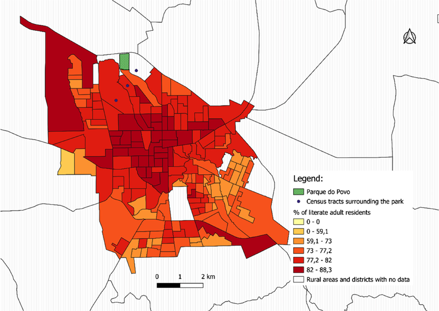 Source: IBGE, 2010 and 2022 Demographic Censuses. Developed by the authors (2025).