
 Assessment of deforestation in southern Amazonas: the status of Boca do Acre over the last decade in light of government inaction
ABSTRACT
Debates involving combat, inspection and mitigation of damage caused by deforestation in the Amazon have gained greater visibility today. In the years 2017 to 2021, with the change in environmental public policies, deforestation jumped from 6,947 km2 to 13,038 km2, however, when these data are analyzed in a longer way, i.e., in the last ten years, it is noted that the loss of vegetation cover in the Brazilian Amazon, has latently increased. In the south of Amazonas, especially in the region of Boca do Acre, the location of this study and isolated municipality of the capital Manaus, it is noticeable that the forest has lost space for pasture areas, creation of cultivars and mainly the illegal deforestation that occurs throughout the territory. . Data from national satellites, such as Landsat TM5, show total deforestation in the last ten years in the study's investigation region, which demonstrates the relevance of discussing, through scientific studies, the impacts caused by anthropic actions. The objective of this study was to evaluate deforestation in the region of Boca do Acre, between the years 2012 to 2022, the data were obtained with the aid of the PRODES Program of the National Institute for Space Research-INPE and the test used to evaluate deforestation in the municipality of Boca do Acre was that of (Pearson). Furthermore, the capture of satellite images was used in an attempt to trigger and quantify deforestation in the study region. After analyzing, filtering and comparing the data, it can be concluded that from 2016 an increasing rate of deforestation begins until 2022, with a small oscillation in 2020 and 2022, among all 10 years, the year 2021 surpassed all other years, with a deforestation rate of more than 200 km2, the total amount was 1,162 km2 deforested between 2012 and 2022, with an annual average of 117 km2.
Keywords
Environmental impact; Deforestation; Satellite images
RESUMO
Os debates envolvendo o combate, fiscalização e a mitigação dos danos causados pelo desmatamento na Amazônia ganharam uma maior visibilidade na atualidade. Nos anos de 2017 a 2021, com a mudança de políticas públicas ambientais, o desmatamento saltou de 6.947 km2 para 13.038 km2, contudo, estes dados, ao serem analisados de maneira mais prolongada, ou seja, nos últimos dez anos, percebe-se que a perda de cobertura vegetal na Amazônia brasileira tem aumentado de forma latente. No Sul do Amazonas, especialmente na região do Boca do Acre - AM, localidade deste estudo e município isolado da capital Manaus, é perceptível que a Floresta tem perdido espaço para áreas de pastagens, criação de cultivares e principalmente o desmatamento ilegal que ocorre em todo o território. Dados de satélites nacionais, como o Landsat TM-5, mostram um desflorestamento total nos últimos dez anos na região de investigação do estudo, o que demonstra a relevância de serem discutidos, através de estudos científicos, os impactos causados pelas ações antrópicas. O objetivo deste estudo foi avaliar o desmatamento na região de Boca do Acre através dos dados de Satélites demonstrando a perda de cobertura vegetal da região e relacionar tais ações com a falta de políticas públicas que possam frear os impactos causados pelas ações antrópicas na Amazônia, entre os anos de 2012 até 2022, Os dados foram obtidos com o auxílio do Programa PRODES do Instituto Nacional de Pesquisas Espaciais-INPE e o teste utilizado para avaliar o desmatamento no município de Boca do Acre foi o de (Pearson). Após análise, filtragem e comparação dos dados obtidos, pode ser concluído que a partir de 2016 inicia-se uma taxa crescente do desmatamento até 2022, com uma pequena oscilação em 2020 e 2022, entre todos os 10 anos, o ano de 2021 superou todos os demais anos, com uma taxa de desmatamento superior 200 km2, a soma total foi de 1.162 km2 desmatados entre 2012 e 2022, com média anual de anual de 117 km2.
Palavras-chave
Impacto ambiental; Desflorestamento; Imagens de satélite
1 INTRODUCTION
Deforestation in the Amazon has been growing at an alarming rate, causing great concern today (Alencar; Silvestrini; Gomes; Savian, 2022; Rossoni; De Moraes, 2022). The Federal Government, through regulatory agencies such as the Brazilian Institute of the Environment and Renewable Natural Resources (IBAMA) and the Chico Mendes Institute for Biodiversity Conservation (ICMBio), seeks to mitigate the damage caused by human activities through public policies. These measures aim to promote reflection on the impacts of burning in the Amazon rainforest and ensure the maintenance of a standing forest, preserving its biodiversity and the ecosystem services provided by a healthy environment.
However, the implementation of these public policies has not been sufficiently effective in containing the impacts of illegal practices associated with deforestation, which mainly manifest themselves through illegal burning, exploitation of fauna, and, above all, the extraction of wood and other products of plant origin (Silvério et al., 2019).
This situation can be seen in the fact that, every year, the state hires temporary firefighters and environmental agents to work in the inspection agencies. However, the results of these actions are still insignificant in view of the need to tackle burning, deforestation, and, consequently, the loss of biodiversity (Dos Santos Lopes et al., 2023).
Da Silva and Pereira (2005) highlight in their study the significant increase in land use change in the Amazon region. Among the factors driving this change, illegal occupations stand out, responsible for intensifying processes of defaunation and deforestation.
In 2022, deforestation in the Amazon reached 96 km2, but this figure rose to 157 km2 in early 2023, representing an increase of 64%. This growth, which has been ongoing for several years, highlights the urgency of discussing measures that can mitigate environmental damage and impacts (Aguiar Júnior, 2023, p. 23).
In southern Amazonas, especially in the municipality of Boca do Acre, the focus of this study, the literature and on-site observations reveal that the advance of logging and the exploitation of other natural resources consolidate the region as one of the main centers of burning, illegal deforestation, and environmental crimes, such as land grabbing and mining (Moutinho et al., 2020).
Land grabbing, in turn, drives other illegal activities, such as mining and illegal hunting. The process involves fraud in land documents for the appropriation of public or indigenous lands, followed by predatory exploitation of the natural resources in these areas (Alencar et al., 2020).
With the weakening of environmental protection policies in Brazil, logging in the Amazon has intensified exponentially. This scenario reinforces the need to expand oversight, both companies authorized to harvest timber than those operating illegally (Branco et al., 2023).
In municipalities further away from the capital, Manaus, the deforestation rate is even more worrying. Among the reasons for this are changes to the Forest Code that reduced Permanent Preservation Areas (APPs) and granted amnesty for illegal deforestation prior to 2008.
These changes encouraged a sense of impunity and new deforestation practices. In addition, the law allowed the regularization of illegally deforested areas through registration in the Rural Environmental Registry (CAR), but in practice, enforcement and environmental recovery have been ineffective. Furthermore, the shortage of civil servants with police powers and the absence of robust public policies exacerbate the problem (Alencar; Silvestrini; Gomes; Savian, 2022).
Between 2020 and 2021, Boca do Acre was classified as one of the locations in Amazonas with the highest volume of logging, ranking fourth in that period (Lemos et al., 2023).
According to Menezes (2009), the intensification of agricultural and logging activities in the Purus and Madeira River regions requires the government to take firm measures to address the environmental, social, and economic impacts of such practices.
Given this context, the objective of this study was to assess deforestation and burning in the municipality of Boca do Acre using satellite images, highlighting the loss of vegetation cover between 2012 and 2022. In addition, we sought to relate these dynamics to the absence of effective public policies to control the impacts of anthropogenic actions in the Amazon.
2 MATERIALS AND METHODS
2.1 Study Area
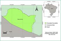
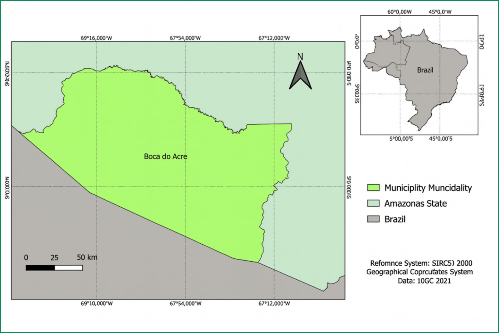
The municipality of Boca do Acre is located between the geographical coordinates of longitude 69°12'45'‘ and 67°03'24’' W, and latitude 8°33'49'‘ and 8°30'34’' S, covering an area of 22,349 km2. In 2022, its population was 35,447 inhabitants (IBGE, 2010). It borders several municipalities in the state of Acre, including Manoel Urbano, Sena Madureira, Bujari, Porto Acre, and Senador Guiomard. Economically, this municipality stands out for its service sector as its main activity, followed by agriculture and livestock, contributing significantly to the GDP of Amazonas (IBGE, 2022).
2.2 Database
Data on deforestation rates (km2) in the municipality of Boca do Acre, Amazonas, between 2012 and 2022, were obtained from the Amazon Deforestation Monitoring Project (PRODES), developed by the National Institute for Space Research (INPE). PRODES detects deforestation through clear-cut analysis, using Landsat series images with a spatial resolution of 30 meters, allowing annual mapping of converted areas at different scales of time and space (INPE, 2022).
In addition, time series data from Landsat 7 satellite images were used, organized into a forest change dataset available on the Google Earth Engine (GEE) platform, which integrates different geospatial layers for large-scale analysis. This database, widel used in studies of vegetation cover dynamics, enables the detection of forest changes over time, contributing to the understanding of the intensity and spatial distribution of deforestation (Hasen et al., 2016).
The methodology adopted consisted of sequential steps: i) definition of the study area corresponding to the territorial limits of the municipality of Boca do Acre; ii) selection and processing of images available on the PRODES/INPE and GEE platforms; iii) quantification of values related to deforestation and changes in forest cover; and iv) export and organization of the results obtained in tabular and spatial format.
This methodological procedure enabled the generation of a consistent database of georeferenced data, ensuring greater accuracy in the analysis of the temporal evolution of deforestation and supporting the interpretation of the associated environmental impacts.
2.3 Statistical test
The statistical test used to assess the increase in deforestation in the municipality of Boca do Acre between 2012 and 2022 was Pearson's correlation coefficient (Pearson, 1895). This test aims to measure the degree of linear association between two quantitative variables, assuming values between –1 and +1. According to its interpretation, values close to –1 indicate a strong negative correlation; values close to 0 indicate no linear correlation; and values close to +1 indicate a strong positive correlation.
In addition to the correlation, a simple linear regression model was applied to assess the temporal trend of deforestation in the study area. The model was structured according to the Equation (1):
where: Y represents the dependent variable (deforestation in km2); a corresponds to the intercept of the line; b is the slope coefficient (slope of the line); x refers to the independent variable (years, from 2012 to 2022).
This statistical approach made it possible to identify not only the direction and intensity of the relationship between time and deforestation rates, but also to estimate the average annual variation in forest cover lost in the municipality.
3 RESULTS AND DISCUSSIONS
The results obtained for the period from 2012 to 2022 in the municipality of Boca do Acre, Amazonas, highlight the severity of the deforestation problem in the region. The municipality was characterized as one of the locations with the highest level of logging in the state, ranking fourth in the list of areas with the highest deforestation activity in Amazonas (Lemos; Cunha; Campos; Brito Filho, 2023).
Illegal burning has also become more frequent in areas in the south of the state, accelerating the degradation of vegetation cover. This process is largely linked to the conversion of forest into areas for pasture to support the expansion of livestock farming (Santos Oliveira et al., 2019). Such practices contribute to irreversible damage to biodiversity, compromising the resilience of local ecosystems.
At the same time, Boca do Acre has consolidated itself in recent years as one of the main municipalities exporting beef to the rest of Amazonas (Brandão, 2023). This reality reveals a strong relationship between the growth of agribusiness and the advance of deforestation, since the expansion of livestock activities has often been prioritized at the expense of forest conservation.
It should be noted that this study does not intend to disqualify the role of agribusiness in the regional economy, especially in a context where many communities depend directly on this production. However, it is essential to recognize that the absence of adequate technical guidance and effective enforcement makes it difficult to reconcile economic development and environmental preservation. The continued reduction of Amazonian forest cover implies significant losses of ecosystem services that are fundamental to humanity, such as climate regulation, biodiversity maintenance, and the provision of natural resources (Setzer; Ferreira, 2022).
The data presented in Figure 2 show that, over the years, the municipality of Boca do Acre has suffered significantly from pressure on land use. The main cause is linked to the expansion of cattle ranching, but there is also evidence of the use of previously forested areas for other agricultural activities, such as goat and even buffalo farming in certain regions (Rocha, 2022).
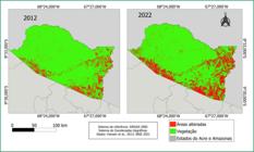
Representation of the increase in deforestation in the municipality of Boca do Acre, Amazonas, between 2012 and 2022
This process reflects a recurring pattern in areas of the Amazon, where the replacement of forest with pasture has been responsible for profound changes in the landscape and a reduction in native vegetation cover.
In 2021, the deforested area in the municipality reached 200.16 km2, surpassing the previous record set in 2019. This advance in environmental degradation reflects the ongoing challenges of forest conservation, driven by agricultural expansion and illegal logging, which act as the main vectors of pressure.
About local ecosystems (Lopes, 2019). This scenario reinforces the need to understand how economic dynamics are intertwined with the weakening of control and enforcement measures.
Furthermore, it can be inferred, both from the analysis in Figure 2 and from empirical observation of the local reality, that the actions implemented by the State have proven insufficient to contain or even mitigate the effects of illegal deforestation in the region. It is therefore necessary to propose more effective strategies to combat deforestation, involving not only repression but also incentives for sustainable production practices.
One indicator of this process is the significant growth in the volume of log wood produced in the municipality: between 2007 and 2019, production increased from 2,922 m3 to 76,000 m3, showing a significant intensification of forest exploitation (IBGE, 2022). This increase is associated with both domestic market demand and external pressures for raw materials, consolidating Boca do Acre as an area of economic relevance, but also of environmental vulnerability.
The literature has characterized the municipality as a new front for deforestation expansion (Piontekowski et al., 2011; Ríos-Villamizar, 2011). However, it is important to note that the timber industry is not the only driver of deforestation. The process involves multiple agents, from large landowners to businesspeople, politicians, and agricultural speculators, who convert the forest into pastureland, thereby increasing pressure on the vegetation cover (Vasconcelos et al., 2011).
The disorderly expansion of the agricultural frontier in this region of the Amazon, especially in areas dedicated to beef and dairy cattle production, has been a determining factor in the reduction of native forest (Prado, 2023). Boca do Acre and neighboring municipalities, such as Pauini, stand out as some of the largest producing areas in the state, according to official records from the Amazonas Agricultural and Forestry Defense Agency (ADAF, 2019). This livestock vocation, although relevant to the local economy, has consolidated in parallel with the advance of deforestation.
Broadly speaking, deforestation in the Amazon is a global concern, as the forest plays a strategic role in climate regulation, biodiversity conservation, and the provision of essential ecosystem services (Setzer; Ferreira, 2022). Therefore, understanding the causes and motivations for deforestation on a regional scale is crucial to supporting public policies that can reconcile production and preservation.
Thus, there is an urgent need to implement effective enforcement and monitoring measures, especially in Conservation Units and legally protected areas. In addition to repression, it is essential to encourage sustainable land use practices and strengthen economic alternatives that do not involve deforestation (De Souza et al., 2022). The correlation observed between the growth of deforestation in Boca do Acre and the weakening of environmental enforcement actions reinforces the idea that the absence of firm policies increases the feeling of impunity.
According to Negrão (2020), in a study on the performance of environmental enforcement agencies in Brazil, the most isolated areas of the Amazon tend to suffer greater omission by public authorities in combating illegal logging. Agencies such as IBAMA and ICMBio have limited performance in remote municipalities due to insufficient staff and structural deficiencies in the exercise of their enforcement functions. This state inertia contributes to the forest losing a significant part of its cover year after year, something that is noticeable not only in scientific studies but also in the daily lives of the populations that inhabit the south and southwest of the Amazon.
In 2021, deforestation in the southern part of Amazonas consolidated itself as a new frontier of devastation, with a 50% increase compared to 2020. The state recorded 129,537 hectares deforested in 2020 and reached 194,498 hectares in 2021, with the municipalities of Humaitá, Lábrea, Apuí, and Boca do Acre being the main contributors to this increase (Vaz, 2022). These figures reinforce the scale of the problem and the need for integrated and effective action.
Discussions about the reasons and loopholes that sustain deforestation in the Amazon have been dragging on for decades, without any effective measures being implemented. It is up to science, through academic research, to keep pressure on the state, urging it to adopt more forceful strategies against illegal deforestation practices. Boca do Acre, thus, represents only the tip of a larger iceberg, since the process of defaunation and forest loss is advancing throughout the Amazon, threatening biodiversity and compromising the region's ecosystem services.
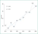
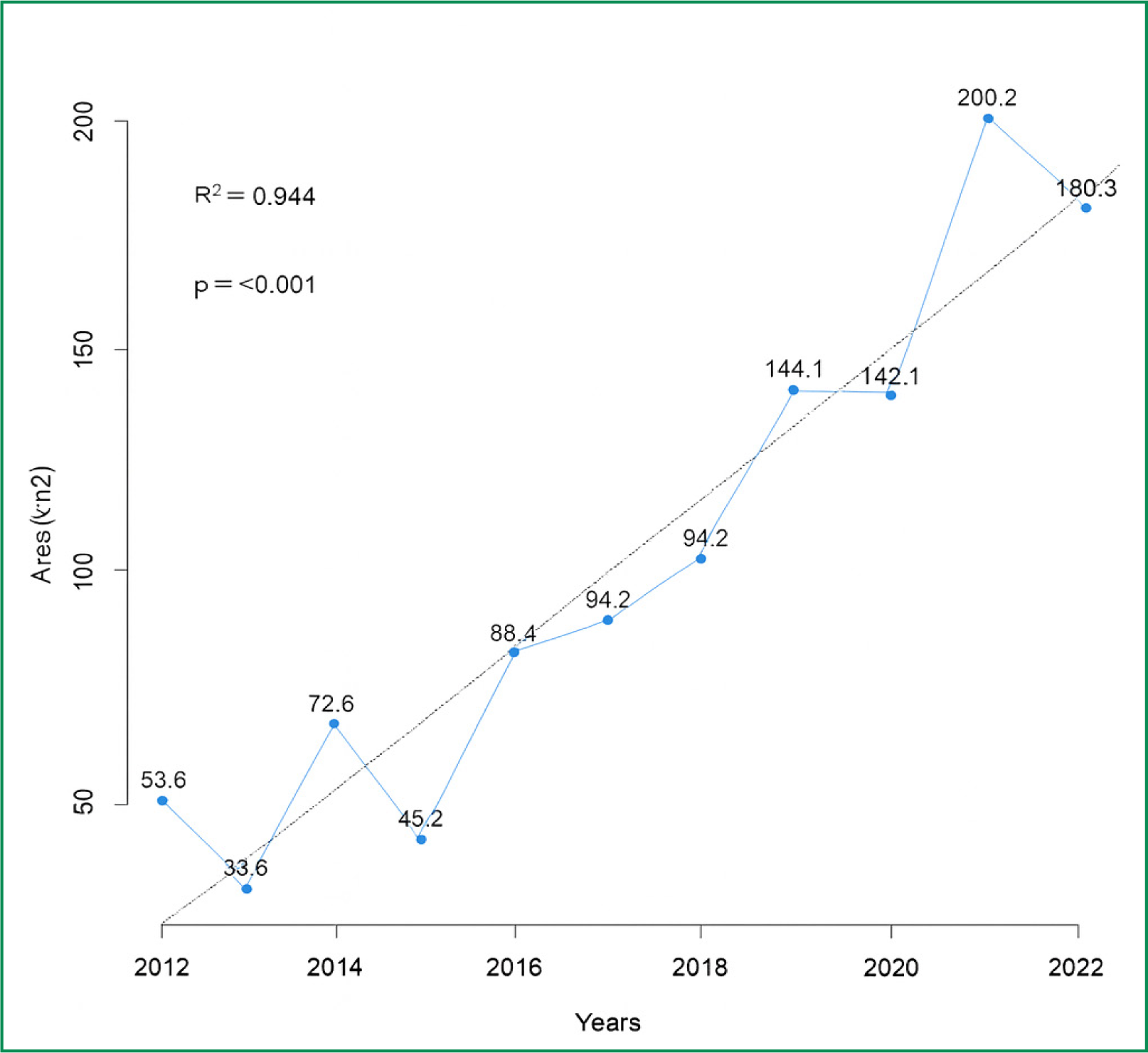
The statistical results obtained reinforce this trend: Pearson's test revealed a correlation coefficient of 0.94, indicating a very strong positive association between time and deforestation rates. The coefficient of determination (R2 = 89%) confirms that most of the variation in deforestation can be explained by the time variable.
The linear regression analysis illustrates this relationship, showing a consistent growth trend over the period studied. Figure 3 allows us to visualize this dynamic, in which each point, accompanied by the trend line, clearly shows the linear pattern of increase in forest suppression between 2012 and 2022.
The expansion of livestock farming in Boca do Acre reflects a historical pattern of Amazonian occupation, in which cattle are not only a source of production but also an instrument of land consolidation. In this sense, Rocha (2022) observes that forest areas have been systematically converted into pastures, not only for cattle but also for goats and buffalo.
Prado (2023) adds that this logic is based on an extensive model of low productivity, in which the opening of new areas replaces the need for productive intensification. As pointed out by ADAF (2019), Boca do Acre and neighboring municipalities stand out as centers of meat production in southern Amazonas, but this economic vocation, devoid of sustainable planning, deepens the cycle of environmental degradation.
Regarding forest exploitation, it should be noted that the timber extracted is not only an economic resource but also plays a strategic role in opening up new areas for agriculture and livestock farming. The IBGE survey (2022) indicates that the volume of log wood produced in the municipality jumped from 2,922 m3 in 2007 to 76,000 m3.
In 2019, showing a notable intensification of activity, Piontekowski et al., (2011) and Ríos-Villamizar (2011) highlight that this phenomenon places Boca do Acre on a new deforestation front, in which logging serves as the initial stage of a process that culminates in the conversion of forest into pasture. Thus, deforestation cannot be understood solely as a result of demand for timber, but as part of a broader dynamic of occupation and transformation of the landscape.
Another central aspect refers to the multiplicity of actors involved in environmental degradation. Vasconcelos et al., (2011) describe that not only small producers are associated with deforestation, but also large farmers, businessmen, politicians, and agricultural speculators, all engaged in transforming the forest into pasture areas.
In line with this perspective, Negrão (2020) highlights the fragility of state action in more isolated areas of the Amazon, where agencies such as IBAMA and ICMBio have a reduced or almost non-existent presence. This inefficiency creates an environment of structural impunity, in which deforestation is perpetuated as a recurring practice, favored by the absence of oversight and the influence of local economic and political groups.
In this context, the impacts are not limited to the municipality but reverberate on a regional and global scale. The reduction of forest cover in Boca do Acre compromises fundamental ecosystem services, such as climate regulation and the maintenance of biodiversity, whose relevance is widely highlighted by Setzer and Ferreira (2022).
To address this situation, De Souza et al. (2022) advocate the adoption of public policies that combine effective monitoring and enforcement with the promotion of sustainable economic alternatives, such as agroforestry systems, bioeconomy, and community management. The quantitative results obtained in this study, which point to a very strong positive correlation (r = 0.94) between time and deforestation, empirically confirm the observations made by the authors, demonstrating that the advance of deforestation follows a linear trajectory consistent, in line with the weakening of environmental governance structures in the region.
The data presented in Figure 3 show the evolution of deforestation in the municipality of Boca do Acre, Amazonas, between 2012 and 2022. The analysis reveals that, throughout the historical series, 2013 was the only year that showed a significant reduction in the deforestation rate, registering 33.6 km2 compared to 53.6 km2 observed in 2012. This one-off drop may be related to circumstantial factors, such as stricter enforcement or specific weather conditions that made burning difficult, but it did not represent a trend. continuity, given that in subsequent years deforestation began to increase again consistently.
The analysis of the time series therefore shows that the trajectory of deforestation in Boca do Acre is marked by occasional annual variations, but within a general trend of cumulative growth over the period. This behavior reinforces the hypothesis that control and enforcement actions were not sufficient to establish a stable reduction pattern, allowing the process of environmental degradation to continue expanding throughout the decade.
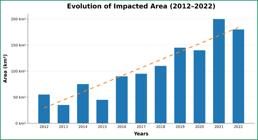
In addition, the results summarized in Figure 4 show the distribution of deforestation in the municipality, highlighting the absolute values in square kilometers recorded in each year analyzed. This graphical representation facilitates understanding of the temporal progression of deforested areas, allowing us to identify not only the years of greatest growth, but also the variations that occurred over the period. An integrated reading of Figures 3 and 4 reinforces the understanding that the municipality has faced a continuous process of forest conversion to agricultural use, with direct impacts on the local landscape.
Thus, the data presented here corroborate the literature that characterizes Boca do Acre as one of the new fronts of deforestation expansion in the Amazon (Piontekowski et al., 2011; Ríos-Villamizar, 2011), showing that the growth of agribusiness, combined with logging and the weakness of state monitoring and enforcement actions, has contributed to the intensification of forest clearing.
As shown in Figure 4, between 2018 and 2022, there was a sharp increase in deforestation in Boca do Acre. This period coincides with a national context in which Brazil suffered from a lack of effective public policies aimed at environmental protection, weakening the mechanisms for inspection and monitoring of the Amazon (Negrão, 2020). The upward curve recorded during this period reinforces the perception that the government's failure to act contributed to the strengthening of predatory practices, creating conditions for the intensification of deforestation.
The distribution graph clearly shows the reality of the region, marked by the prominence of large landowners, logging consortia, and illegal burning, all acting as central vectors of degradation. This finding requires urgent decision-making by the State on how to intervene in the face of advancing environmental destruction. Starting in 2016, there has been a consistent increase in deforestation, which is expected to continue until 2022, with slight fluctuations in 2020 and 2022.
The year 2021 stands out for having the highest rate recorded in the period, with more than 200 km2 of deforested area. Over the decade, the municipality lost 1,162 km2 of forest cover, which corresponds to an annual average of 117 km2, an alarming figure for a location whose economy could be more aligned with sustainable land use practices.
These results emphasize the need for the municipality to develop specific intervention plans for critical periods, when burning and illegal logging are most intense. Effective regulation of natural resource use could not only preserve the forest but also offer social and economic benefits to local communities, ensuring a balance between development and conservation.
According to Ramírez, Pérez, and Cutiño (2022), fires in the Amazon increased by about 74% in 2020 alone, compared to data from the 1990s. However, it is important to note that fires are not the only factor responsible for deforestation. Land grabbing, illegal mining, wild animal capture, and clearing areas for pasture are also fundamental elements of this dynamic, as evidenced throughout this study.
In the Boca do Acre region, logging stands out as one of the main causes of forest loss (Fonseca; Lopes; Valente, 2013). Logging, often carried out illegally, occurs without proper environmental care and without compliance with protection standards, increasing the ecological vulnerability of the region.
As Da Silva Santos and Da Silva (2022) point out, the local population lives daily with the direct impacts of these practices, from the reduction of biodiversity to the degradation of natural resources that sustain traditional ways of life. The inertia of public authorities in the face of these pressures further aggravates the situation, reinforcing the urgency of stronger embargo and enforcement measures.
Understanding the environmental impact caused by humans in this part of the Amazon implies recognizing that deforestation is not limited to a question of forest loss, but triggers a systemic process that affects fauna, flora, and the human communities themselves that depend on forest resources for their subsistence (Menezes, 2009).
Illegal and rampant destruction compromises both the integrity of ecosystems and socio-environmental resilience. Therefore, studies that assess deforestation in isolated locations, such as Boca do Acre, are essential to provide a detailed overview of the environmental and socioeconomic consequences associated with anthropogenic actions.
In this context, deforestation not only reduces vegetation cover but also generates profound side effects, such as biodiversity loss, soil erosion and impoverishment, changes in hydrological and carbon cycles, and directly contributes to global climate change (Da Silva; Pereira, 2005). These impacts demonstrate that maintaining the forest standing is an essential condition not only for regional preservation but also for environmental stability on a planetary scale.
4 CONCLUSIONS
The objective of this study was to assess deforestation and burning in the municipality of Boca do Acre, Amazonas, between 2012 and 2022, using satellite images and statistical analyses to identify the evolution of vegetation cover loss and relate these processes to the absence of effective public environmental control policies.
The results confirm that deforestation showed an increasing trend over the decade, with emphasis on the year 2021, when the highest rate for the period was recorded, exceeding 200 km2 of deforested area. In total, the municipality lost approximately 1,162 km2 of forest, with an annual average of 117 km2, which highlights the intensity of the process.
Pearson's correlation and linear regression analyses showed a very strong positive association (R = 0.94; R2 = 89%), confirming that the time variable largely explains the advance of deforestation. The interpretation of the maps and graphs (Figures 2, 3, and 4) also showed the systematic replacement of vegetation cover by areas used for cattle ranching and logging, corroborating the findings of authors who characterize Boca do Acre as a new front for the expansion of forest degradation in the Amazon.
Thus, the study's objectives were fully achieved, since it was possible to quantify the evolution of deforestation, spatialize vegetation loss, and relate these phenomena to the predominant anthropogenic pressures, such as extensive cattle ranching, illegal logging, and land grabbing. In addition, the research reinforced the understanding that the absence of robust public policies, combined with weak enforcement in isolated areas, contributes decisively to the intensification of deforestation in the region.
It is concluded that it is essential to implement more effective environmental management strategies capable of promoting reconciliation between economic production and forest conservation. Among the priority measures, the following stand out: strengthening environmental enforcement through a greater presence of competent agencies, continuous monitoring using remote sensing technologies, creating incentives for sustainable production practices, and investing in economic alternatives based on the bioeconomy. Only in this way will it be possible to ensure the preservation of the Amazon rainforest in Boca do Acre and, consequently, guarantee the maintenance of essential ecosystem services for local populations, for Brazil, and for global climate balance.
ACKNOWLEDGEMENTS
The authors would like to thank CAPES for granting the Doctoral Scholarship and the Federal University of Acre (UFAC), which, through the Office of the Dean of Research and Graduate Studies (PROPEG), provided resources for conducting the study through Public Notice 26/2025.
Data Availability Statement:
Datasets related to this article will be available upon request to the corresponding author.
REFERENCES
- ALENCAR, A.; SILVESTRINI, R.; GOMES, J.; SAVIAN, G. Amazonia in flames: the alarming new level of deforestation in the Amazon. IPAM Amazonia, pp. 1-21, 2022.
- ALENCAR, A. et al. Amazonia on fire: the new and alarming level of deforestation in the Amazon. Brasília: Amazon Environmental Research Institute, IPAM Amazonia, 2022.
- AGRICULTURAL AND FORESTRY DEFENSE AGENCY OF THE STATE OF AMAZONAS - ADAF. Foot-and-Mouth Disease Vaccination Coverage in Amazonas – 1st stage 2019 Boca do Acre –AM, 2019.
-
AGUIAR JÚNIOR, H. de. Environmental civil liability as a response to deforestation in the Legal Amazon: what the empirical analysis of public civil actions filed under the “Amazônia protege” project reveals. Dissertation (Professional Master's Degree in Economic Law and Development) – Brazilian Institute of Education, Development, and Research (IDP), Brasília, 2023. Available at: https://repositorio.idp.edu.br//handle/123456789/4345 Accessed on: 01 Oct. 2025.
» https://repositorio.idp.edu.br//handle/123456789/4345 -
BRANCO, T. L.; GRAÇA, P. M. L. A.; YANAI, A. M.; CABRAL, B. F.; DUTRA, D. J.; ANDERSON, L. O.; ARAGÃO, L. E. O. C.; FEARNSIDE, P. M. Evolution of forest degradation by Logging and deforestation from 2007 to 2019 in the municipality of Boca do Acre, Amazonas. In: BRAZILIAN SYMPOSIUM ON REMOTE SENSING, 20. (SBSR), 2023, Florianópolis. Proceedings.. São José dos Campos: INPE, 2023. p. e156108. Internet. ISBN 978-65-89159-04-9. IBI: 8JMKD3MGP6W34M/4945AGE. Available at: http://urlib.net/ibi/8JMKD3MGP6W34M/4945AGE Accessed on: 01 Oct. 2025.
» http://urlib.net/ibi/8JMKD3MGP6W34M/4945AGE - BRANDÃO, C. A. P. Overview of cattle farming in the municipality of Parintins - Amazonas. 2023. 143 f. Dissertation (Master's Degree in Animal Science and Fishery Resources) - Federal University of Amazonas, Manaus (AM), 2023.
- DA SILVA SANTOS, R. M.; DA SILVA, N. M. The challenges for effective environmental governance at the municipal level in cities in the Amazon: coordination, implementation of public policies, and the role of the State. Research, Society and Development, v. 11, n. 11, p. e340111133574-e340111133574, 2022.
- DOS SANTOS LOPES, M. J.; SANTIAGO, B. S.; DA SILVA, I. N. B.; GURGEL, E. S. C. Impact of deforestation and burning on the invisible biodiversity of the Amazon. Journal of Agribusiness and Environment, v. 16, n. 1, p. 1-14, 2023.
- DOS SANTOS OLIVEIRA, E.; DA COSTA, S. E.; DE LIMA, N. J.; CAMPELO, F. R.; DA SILVA, G. R.; DE LIMA, S. S. Incidence of dengue cases in the municipality of Boca do Acre in 2013 and the first half of 2019. Cross-Border Geopolitics Magazine, v. 1, n. 2, p. 48-60, 2019.
- DA SILVA, K. E.; PEREIRA, K. P. Changes in natural vegetation cover in municipalities in southern Amazonas 2005.
- DE SOUZA, S. A. S.; QUREINO, C. A. C.; DA SILVA QUERINO, J. K. A.; DA SILVA MARTINS, P. A.; VAZ, M. A. B. PRECIPITATION VARIABILITY IN THE SOUTHERN MESOREGION OF AMAZONAS AS A RESULT OF EL NIÑO EVENTS. RAEGA-O Espaço Geográfico em Análise, v. 54, p. 23-36, 2022.
- FONSECA, A. M. T.; LOPES, M. C.; VALENTE, L. M. Diagnosis of crimes against flora based on actions brought by the federal public prosecutor's office. Electronic Journal of the UFSM Law Course, v. 8, n. 1, p. 122-140, 2013.
- HANSEN, M. C.; KRYLOV, A., TYUKAVINA, A., POTAPOV, P. V., TURUBANOVA, S., ZUTTA, B. MOORE. Humid tropical forest disturbance alerts using Landsat data. Environmental Research Letters, v. 11, n. 3, p. 034008, 2016.
-
IBGE, BRAZILIAN INSTITUTE OF GEOGRAPHY AND STATISTICS, 2010. Census data published in the Federal Official Gazette: Population in 2010. Rio de Janeiro: IBGE, 2010. Available at: http://www.censo2010.ibge.gov.br/dados_divulgados/index.php?uf=13 Accessed on: 01 Oct. 2025.
» http://www.censo2010.ibge.gov.br/dados_divulgados/index.php?uf=13 -
IBGE, BRAZILIAN INSTITUTE OF GEOGRAPHY AND STATISTICS, 2022. IBGE Cities [S. l.: s. n.], 2022. Available at: https://cidades.ibge.gov.br/ Accessed on: 01 Oct. 2025.
» https://cidades.ibge.gov.br/ -
IBGE, BRAZILIAN INSTITUTE OF GEOGRAPHY AND STATISTICS, 2022. Estimates of the resident population in Brazil and federative units with reference date July 1, 2022 Rio de Janeiro: IBGE, 2022. Available at: https://www.ibge.gov.br Accessed on: 01 Oct. 2025.
» https://www.ibge.gov.br -
INPE, NATIONAL INSTITUTE FOR SPACE RESEARCH, 2019. Annual deforestation rate between 1988-2018 Available at: http://www.obt.inpe.br/prodes/dashboard/prodes-rates.html Accessed on: 01 Oct. 2025.
» http://www.obt.inpe.br/prodes/dashboard/prodes-rates.html - LOPES, E.; BRASIL, F.; OLIVEIRA, G.; CONCEIÇÃO, G.; SOUZA, J.; GOMES, T.; SILVA, W.; TELES, W. Economic impacts of livestock farming on the population of the municipality of Boca do Acre. Revista Geopolítica Transfronteiriça, v. 1, n. 2, p. 39-47, 2019.
- LEMOS, N. S. A.; CUNHA, J. M.; CAMPOS, M. C. C.; BRITO FILHO, E. G.; Forest fire distribution Standard in the South of Amazonas state 2023.
- MENEZES, T. C. C. Expansion of the agricultural frontier and mobilization of traditional peoples in southern Amazonas. Complexo Madeira, p. 231, 2009.
- MOUTINHO, P.; ALENCAR, A.; RATTIS, L.; ARRUDA, V.; CASTRO, I.; ARTAXO, P. Amazonia in flames: deforestation and fire in times of COVID-19. Technical Note, no. 4, 2020.
- NEGRÃO, M. de. F. F. Evaluation of vegetation monitoring systems in the Amazon used for environmental enforcement activities. Monograph/Final Course Project 2020.
- PEARSON, K. Notes on regression and inheritance in the case of two parents. Proceedings of the Royal Society of London, 58, 1895. 240–242.
- PIONTEKOWSKI, V. J.; DA SILVA, S. S.; PINHEIRO, DA. S. T.; COSTA, C. F.; MENDOZA, H. R. E. The advance of deforestation in the municipality of Boca do Acre, Amazonas: Case study along the BR-317 highway. Proceedings of the XV Brazilian Symposium on Remote Sensing, Curitiba, Brazil, pp. 3021–3028, 2011.
- PRADO, S. O. Seasonality of the thermal comfort index for dairy farming in three municipalities in the southern region of Amazonas. 42 p. Final Course Project (Bachelor's Degree in Agronomy) - Federal University of Amazonas, Humaitá (AM), 2023.
- ROSSONI, R. A.; DE MORAES, M. L. Agriculture and deforestation in the Brazilian Amazon: a spatial analysis between 2007 and 2017. Geografia em Questão, v. 13, n. 3, 2020.
- ROCHA, F. I. et al. Soil moisture dynamics in pastures with different levels of bovine periodontitis in Boca do Acre, Amazonas. Simulation of Water and Solute Flows in the Soil, 2022. EXPANDED ABSTRACT Rio de Janeiro. Rio de Janeiro: Ed. dos Autores, 2022. p. 1-6.
- RORIZ, P. A. C. How the new Forest Code (Law No. 12,651/2012) affects deforestation in the municipality of Boca do Acre-AM. 2013. Dissertation (Master's Degree in Sustainable Development) – University of Brasília, Brasília, 2013.
- RÍOS-VILLAMIZAR, E. A.; JUNIOR, A. F. M.; WAICHMAN, A. V.. Physical-chemical characterization of water and deforestation in the Purus River basin, Western Brazilian Amazon. Revista Geográfica Acadêmica, v. 5, n. 2, p. 54-65, 2011.
- SILVÉRIO, D.; SILVA, S.; ALENCAR, A.; MOUTINHO, P. Amazonia in flames Technical Note from the Amazon Environmental Research Institute (IPAM), 2019.
- VASCONCELOS, S. S.; FEARNSIDE, M. P.; GRAÇA, DE. A. L. M. P.; NOGUEIRA, M. E. Mapping of areas affected by forest fires in southern Amazonas and estimates of potential carbon emissions. Proceedings of the XV Brazilian Symposium on Remote Sensing, Curitiba, Brazil, pp. 8059-8066, 2011.
- VEZZANI, F. M. Soils and ecosystem services. Brazilian Journal of Physical Geography, v. 8, pp. 673-684, 2015.

 Source: Adapted from IBGE (2021)
 Source: Adapted from Hansen et al. (2013) and IBGE (2021)
 Source: Adapted from PRODES/INPE (2022)
 Source: Adapted from PRODES/INPE data (2022)