 Analytic Hierarchy Process (AHP) and GIS applied to the adequacy of forest roads in southern Brazil
Abstract:
This study aims to optimize the planning of forest road networks using the Analytic Hierarchy Process (AHP) integrated into a Geographic Information System (GIS) environment. The variables used in this study were: permanent preservation area (PPA), slope (S), slope orientation (SO), commercial volume of timber (CV), and land cover class (LC). The best scenario was achieved when the five variables were employed in the AHP analysis, with a coherence index (CI) of 0.04%, and a consistency ratio (CR) of 3.9%. Then, the suitability of the existing forest roads was verified using the least-cost path tool associated with the map provided by the best AHP scenario. The results indicate that only 1/3 of the roads are placed in areas classified as ‘good’ or ‘optimal’, suggesting that the current road network can be improved. Adopting the road network proposed by this study, the length and density of roads would decrease by 10%. Consequently, a reduction in transport costs and an increase in the planted area are expected. We propose that this cost-effective approach can be leveraged for the reappraisal and suitability assessment of forest road density in areas exhibiting substantial timber resources, including those managed by mature forest enterprises.
Keywords:
Geographic Information System (GIS); Production; Pinus
1. Introduction
Roads serve the purpose of enabling efficient transportation of timber logs, addressing cost- and supply-related challenges (Malinovski 2010). Forest roads also serve as the main access to forest stands for implementing silvicultural practices and conducting interventions over time, in addition to harvesting operations. However, the role of forest roads is beyond their economic purpose; they also fullfill social, economic, and environmental functions (Souza et al. 2018; Azari et al. 2023).
Forest harvest planning is based on the existence of roads within the area of interest. From these roads, cutting directions, extraction paths, and truck routes over eventual and temporary roads are determined, forming the foundation for the overall operation plan. Roads currently serve as the guiding framework for all forestry operations.
According to Straka and Martin (2017), forest roads are essential infrastructure for providing access to forest harvesting activities. In recent years, the topic of forest roads has gained significant attention due to their critical role in rural and forest landscapes, as well as their impact on the efficiency of forest extraction and transport operations (Grigolato et al. 2013).
According to Parsakhoo et al. (2010), forest roads are the most important basis for sustainable forest operations while playing an important role in environmental protection. Good forest roads are crucial for effective forest protection and management (GUMUS et al. 2017), regardless of their main objectives (Castro and Santos-Berbel 2015; Laschi et al. 2016, 2019).
Strategic road network planning is essential to ensure efficient access to production areas, facilitate optimized timber flow, minimize costs, and fulfill operational requirements, all while addressing critical social and environmental concerns. Lack of planning can lead to excessive investment in roads and loss of productive areas (Souza et al. 2018). As a clear consequence, logistics costs can increase the production cost of the final product.
Efficient planning of roads enables the optimization of operational costs related to wood harvesting and road construction activities, while also reducing environmental impacts and maximizing the use of productive areas available for forestry plantations. Given the clear need for efficient planning that considers both environmental and operational variables, it is essential to develop technologies to assist managers in this process (Morais et al. 2023).
As a practical example, some researchers have applied GIS and spatial analysis techniques to determine the ideal density of forest roads in the forest of northern Iran (Parsakhoo et al. 2010). Their findings demonstrated that using GIS and computerized analysis saves time, costs, and minimizes environmental damage
According to Oliveira Filho et al. (2005), integrating GIS with road-specific variables-including horizontal and vertical geometry, surface quality, and width-significantly improves decision-making. Beyond efficient road density planning, defining optimal routes is crucial to ensure they meet the standards required for timber transport. This necessitates considering key variables such as slope, solar orientation, and timber volumes, while strictly avoiding Permanent Preservation Areas (PPA) and native forest.
Methods for defining the optimal road layout, as noted by Akay and Yilmaz (2017), can be addressed using multi-criteria analysis integrated with GIS. Souza (2019) provided a review analysis highlighting that GIS tools are highly relevant in route planning operations, as they assist planners in identifying accessible and inaccessible areas and determining the necessary road network for a given operation. However, according to Saaty (2008a b), defining priority locations for road construction and prioritizing the criteria involved is often subjective. This subjectivity underscores the importance of validating the process through frameworks that represent the flow of influences, such as the Analytic Hierarchy Process (AHP).
AHP is a decision support tool designed to address complex decision-making problems. It employs a multi-level hierarchical structure consisting of objectives, criteria, sub-criteria, and alternatives. Relevant data is derived through a series of paired comparisons, which are used to determine the importance weights of decision criteria and the relative performance measures of the alternatives with respect to each criterion. In cases where comparative inconsistencies arise, the method offers a mechanism for consistency improvement (Triantaphyllaou and Mann 1995).
Shiba (1995) emphasizes that the AHP method helps decision-makers prioritize objectives and establish a systematic set of criteria. It also assists in logically preparing evidence to select the most suitable road network alternative based on multi-criteria analysis. By conducting pairwise comparisons of multiple variables, the method enables the definition of importance criteria and their respective weights, aiding in the identification of optimal locations for forest roads.
According to Samani et al. (2010), integrating AHP with GIS is an effective approach for road planning. The method identifies optimal and suboptimal locations for road development, further determining the most efficient road path.
In this study, we propose an approach to optimize forest road planning using the AHP method within a GIS environment. A scenario with five variables was analyzed: slope (S), and slope orientation (SO), and forest inventory data (e.g., commercial timber volume (CV), land cover (LC) maps, and PPA. The proposed approach served a dual purpose: evaluating the existing forest roads within a Pinus sp. plantation and developing a suitability map for its forest road network.
2. Material and Methods
2.1 Description of the study area
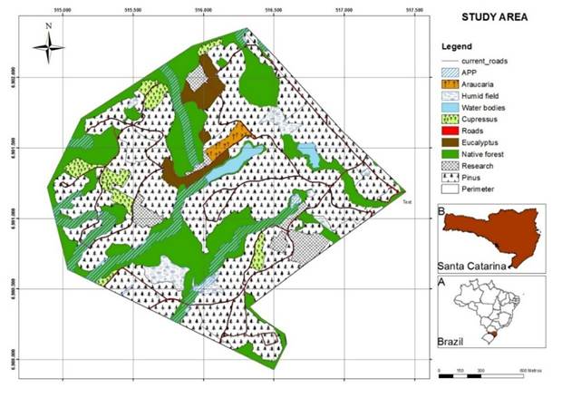
This study was conducted in the municipality of Campo Belo do Sul, located in Southern Brazil (Santa Catarina State) (Figure 1). The research area consisted of a Pinus sp. forest farm owned by the company Florestal Gateados. The selected forest farm spans 310.41 ha, corresponding to 3% of the total effective area and 1.4% of the company’s total area. Features predominantly undulating to strongly undulating, with an average altitude of 1017 m above sea level. The slope in the area ranges from 8% to 45%, which, according to the EMBRAPA (1999) classification, corresponds to wavy to strong wavy reliefs. The land use is predominantly dominated by planted forests, with the surrounding areas comprising PPAs and fragments of mixed ombrophilous tropical forest, also known as Araucaria Forest.
Location of the study area within national (A) and state (B) contexts. A detailed land cover map of the study area is also shown.
The climate of the region, according to the Köppen classification, is Cfb (humid mesothermal, characterized by a lack of a defined dry season, mild summers, and with the occurrence of severe and frequent frost in winter) (Pandolfo et al. 2002). According to EPAGRI (2002) data, the annual mean temperature is around 15 °C, and the mean annual rainfall is 1400 mm.
The characteristics previously discussed are widespread throughout the Southern Plateau of Santa Catarina, a region where numerous forest companies are based. The study area was selected because harvesting had already occurred, and, according to the local forest company, this would be the most suitable time for readjusting the forest road design, thereby avoiding harvesting in early-aged, planted forest stands. Consequently, this would also avoid extra costs for its implementation when necessary.
2.2 Input Data and Spatial Analysis
Data for this study were sourced from the local forest company. This included hydrographic information, detailing the drainage network and springs of the study area, as well as the road network, which was already classified as primary, secondary, and access routes. Both of these foundational datasets were generated through topographical surveys employing Total Stations and Global Navigation Satellite System (GNSS) receivers. Additionally, Continuous Forest Inventory maps were incorporated, providing CV for the diverse planted forest species present in the study area.
The selection of spatial variables in our GIS-AHP model follows recent advances in forest road planning that emphasize the joint consideration of legal constraints, terrain conditions, stand attributes and environmental sensitivity. In Amazonian concessions, Morais et al. (2023) explicitly integrated maps of Permanent Preservation Areas (PPA) and slope derived from a digital elevation model into a least-cost path model to obtain road layouts with better economic and environmental performance, showing that PPAs are an essential constraint layer for road location under the Brazilian Forest Code.
Consistently, several GIS-MCDA/AHP applications in mountainous forests identify slope and slope orientation (aspect) among the most influential criteria because they strongly control earthwork volumes, construction costs and geo-hazard susceptibility along forest roads (Mohammadi Samani et al. 2010; Naghdi et al. 2012; Çalışkan et al. 2019; Kucuker 2025). Commercial timber volume and land-cover classes are also widely used to guide road density and alignment towards productive stands while avoiding environmentally sensitive land uses, thus improving economic efficiency and reducing impacts (Naghdi et al. 2012; Shahsavand Baghdadi et al. 2011; Acosta et al. 2023).
In line with this literature, our model treats PPA as a hard constraint and combines slope (S), slope orientation (SO), commercial volume (CV) and land-cover class (LC) within the AHP framework to represent, respectively, terrain operability, exposure and stability, spatial distribution of harvestable timber, and the environmental sensitivity of the landscape. A detailed LC map was generated based on the visual interpretation of ultra-high spatial resolution images acquired from the Airborne System for Acquisition and Post-processing of Images (SAAPI). The LC was identified and characterized in terms of its structural properties and spatial representativeness. This procedure was performed manually using geoprocessing editing tools available in GIS. We maintained a compatible scale for visualizing the SAAPI image. This step also benefits from inspecting spectral profiles and changing color compositions for visual interpretation. Intensive field surveys were also conducted to ensure good overall accuracy. The following LC classes were considered: stands containing Araucaria angustifolia, Cupressus spp., Eucalyptus spp., and Pinus spp., were labeled as well as wetlands, water bodies, native forests, and areas designated for interdisciplinary research.
The SAAPI sensor rendered images in blue, green, red, and three near-infrared spectral bands at the spatial resolution of 0.39m. Additionally, based on these images, the airborne survey also delivered a detailed DEM with a spatial resolution of one meter. While the first product refers to a digital surface model (DSM), a second product was also generated detailing the terrain features, labeled as a digital terrain model (DTM). The airborne survey was performed between 2010 and 2011 for the entire state of Santa Catarina, and all their products are publicly available at https://sigsc.sc.gov.br/. Examples of data usage are available in PIAZZA et al. (2016) and SOTHE et al. 2016. Here, we used DTM to generate both slope (S) and SO products.
After mapping the water bodies, wetlands, and the drainage network, a buffer was generated to determine the permanent protected area (PPA). According to the Brazilian Forest Act (Brasil, 2012a), it is forbidden to consider any infrastructure, including building roads in PPA areas. However, an exception applies in consolidated areas (i.e., areas with anthropic occupation before July 22, 2008). However, for conducting this research, and guided by the company rules, we consider a strong restriction for PPA. A better perception of the impact of environmental legislation on rural farms in the region is given in Bonamigo et al. (2017).
A geodatabase was then created, incorporating all the thematic layers, and considering the UTM projection and the reference system SIRGAS/2000. Given the spatial resolution of the input datasets, the recommended cartographic scale delivered for printed maps is 1/10.000. However, we performed the editing and visualization at a finer scale whenever possible. To check for data consistency, we performed a topological analysis on the vector datasets. For polygons, the topological analysis was: Must be larger than cluster tolerance. This analysis identifies the minimum distance between vertices and requires a feature that does not collapse during a validation process. This rule is mandatory for topology and applies to both line and polygon feature classes. In instances where this rule is violated, the original geometry is left unchanged (ESRI 2024). To be supplementary to lines, the criteria were: must not overlap and must not intersect. For points, they must not intersect and must have no pseudo nodes. Points are created only where the end of a line touches the end of another line (ESRI 2024). All the geoprocessing processing steps were conducted using GIS.
2.3 Analytic Hierarchy Process (AHP)
The pairwise matrix proposed by Saaty (1987; 1990, 2008a b) involves variables in analysis that are compared among themselves regarding their importance in relation to a given problem. Therefore, for the AHP, the criteria were analyzed in pairs, using weights of 1, 3, 5, 7, and 9. The value of 1 represents that a given variable on the row has the same importance as the variable in the column. Thus, a value of 9 means that the variable on the row is much more important than the variable in the column. Intermediate values have variations ranging from little, strong, and very strong importance.
In summary, the weights were defined by pairwise comparison between the PPA, S, SO, CV, and LC variables. These variables were chosen due to their availability, and after consulting professionals from the forest sector to define forest roads.
The adopted criteria used in this study were based on the judgment of the company’s employers and local forest experts, based on their accumulated experience. Such interviews enable us to rank the criteria that are most important for forest roads. The adopted criteria selection aligns firmly with the guidelines proposed by Gumus (2017) for assessing stakeholder perception differences in forest road valuation variables using the AHP.
Interestingly, the questionnaire basically requested each interviewer to rank the variables and select a score ranging from 1 to 9 once each of the ten possible groups of two variables was presented side by side. The interview respected the principles guided by Resolution 466/2012 (Brasil 2012b). It is essential to note that the questionnaire was conducted with the free and informed consent of participants, whether individuals or groups, who, either themselves or through their legal representatives, expressed their agreement to participate in the research, as it was related to graduate research.
After the paired assignment of importance, the consistency index (CI) and the consistency ratio (CR) were calculated to verify whether the assigned weights are coherent with the weighting of the variables. Saaty (1986) suggests that the CR value should be lower than 0.1 (or 10%). Interestingly, the literature also supports the importance of the selected variables for planning forest roads. Samani et al. (2010) state that the variables S, LC, hydrography, SO, and volume should always be considered when planning forest roads. According to Akay & Yilmaz (2017), these variables are a limiting factor for transporting timber due to the very high road grades. Similarly, Norizah & Hasmadi (2012) suggested the use of SO, soil texture, and S for road planning. According to Parskhoo (2016), the variables S, depth of the soil, and the proximity to the hydrographic network were the most important parameters used to plan the construction costs of forest roads.
2.4 Data processing
Initially, the vector files were converted to raster files and subsequently reclassified. The reclassification consisted of altering the values of cells to scale the importance of each predefined criterion. Map algebra was employed for reclassification. The scores used in this step were defined by Samani et al. (2010):
-
PPA: values 1 and 9 assigned for PPA and outside the PPA domain.
-
S: value 3 assigned for areas with S>30°; value 5 for areas with S ranging from 20 to 30°; value 7: areas with S between 10 and 20°; value 9 for areas with S<10°. The mentioned intervals were chosen because they are important for defining the most suitable engines to harvest the trees in a given forest stand.
-
SO: value 3 for areas with low sun incidence (south face); value 5 for areas with little sunlight; value 7 for areas with sunlight; value 9 for areas with intense sunlight throughout the day (north face).
-
CV: was divided into volumetric classes with the following values: 1 for CV up to 77 m³·ha-1; 3 for CV between 77 and 94 m³·ha-1; 5 for CV between 94 and 110 m³·ha-1; 7 for CV between 110 and 128 m³·ha-1; and 9 for CV >128 m³·ha-1;
-
LC: values 1, 5, and 7 for PPA, natural forest, and planted forest, respectively.
The weights derived for each data input were applied to the respective reclassified raster files, generating thematic maps with suitability classes for constructing forest roads. Afterward, both CI and CR were calculated in GIS with the AHP tool. The scenario, which utilized the five variables, was employed to evaluate the existing roads and propose a new network using the least-cost path. It is worth noting that areas with slopes exceeding 45º were only found in native forest remnants within the study area. The Brazilian Forest Act covers such areas as being PPA.
2.5 Least cost path
We used the least-cost path analysis, based on AHP, to define the most economical road paths within the study area. This analysis automates the process by determining the least-cost path between an origin and a destination. After defining the new path, it considers the farthest forest stands and the logging yard. We then compared the original path to the proposed ones.
According to Chang (2012), the least-cost analysis calculates the minimum cost to determine the segment between two points, with the cost of an area evaluated using raster data, where cell values represent the cost of each cell. The analysis assesses the eight neighboring cells of a single pixel and identifies the neighboring cell with the lowest accumulated cost. This iterative process continues until the start and endpoints are connected.
Pingel (2010) explains that this analysis involves multiplying costs represented by a raster cost base, such as distance, and a raster spending cost, such as S. The process treats raster pixels as interconnected network nodes. Utilizing shortest-path algorithms within a GIS, a lower-cost path can be computed from this network.
3. Results and Discussion
3.1 Results of the AHP method
Table 1 shows the paired analyses and the percentage of importance assigned to each variable.
From the paired analyses (Table 2), the PPA (38.9%) emerged as the most significant variable, followed by S at 34.0%, CV at 15.9%, LC at 7.2%, and SO at 4.0%. These results indicate that PPA should be prioritized when defining a forest road path, with S, CV, LC, and SO ranked in decreasing order of importance.
The CI was 0.04, and the CR was 3.9%. According to Saaty (1986), a CR value below 0.1 (or 10%) is considered acceptable. The scenario analyzed in this study adheres to this guideline, reflecting reliable decision-making outcomes.
In this study, a scenario using all five available variables was chosen. The ideal number of variables or criteria vary across other studies. For example, Parsakhoo (2016) used three variables to determine optimal road construction locations: S, soil depth, and proximity to the hydrographic network. Similarly, Hayati et al. (2013) employed three criteria - S, soil texture, and susceptibility to landslides - for forest roads planning. Norizah & Hasmadi (2012) used four variables, including S, proximity to rivers, elevation, and distance to the existing roads, to define the best path for road construction. Finally, Samani et al. (2010) considered seven variables: S, soil type, geology, hydrographic network, individual tree volume, tree type, and elevation.
Despite the varying number of variables used, none of these studies explicitly justified their chosen criteria. In this research, five variables were selected due to their relevance to the local forestry company and their contribution to achieving favorable CI and CR scores.
The CI result was 0.04 and the CR the 3.9%. These findings align with the results of Norizah & Hasmadi (2012), who identified S as one of the factors among PPA, elevation, and existing roads, assigning it a weight of 0.558. Similarly, Samani et al. (2010) found that S, hydrographic network, geology, and soil were the most significant criteria for planning forest roads. Complementing these findings, Kady et al. (2019) A dynamic algorithm was developed to optimize forest road routing using landslide susceptibility analysis, revealing that about 39% of existing roads are at risk of landslides.
S is widely recognized as a critical variable in forest road planning. Areas with steep slopes may restrict machinery from accessing forest stands or necessitate specialized forest road designs (Malinovski & Perdoncini 1990; Akay & ErdaŞ 2007). High slopes also pose challenges for truck traffic, hindering timber transportation (Akay & Yilmaz 2017; LABELLE et al. 2022). According to Kunwoo et al. (2000), planning roads in areas with low to moderate S and stability can significantly reduce construction costs associated with excavation. In a cost-benefit analysis, CV is another essential factor in forest road planning. Roads with high traffic volumes due to time transportation increase production costs, but these costs tend to decrease after reaching a threshold of viability. Malinovski (2010) highlighted CV as a crucial variable because it directly affects road construction costs and, consequently, the overall production cost. Typically, the construction cost of a forest road is amortized based on the total volume of timber extracted and transported via that road (Machado 1989).
The relative importance of variables in forest road planning can vary across studies. For example, Akay & Erdas (2017) reported different rankings of variable importance, which could be attributed to the emphasis placed on PPA in specific studies. In this analysis, the significance of PPA was heightened because roads are prohibited near these areas. PPAs, which often surround water bodies and wetlands, are highly sensitive to forest construction and play a vital role in preserving biodiversity (Machado & Silva 2001; Silva et al. 2017).
Machado & Silva (2001) observed that forest roads established near water streams significantly increase sediment runoff, with roads near streams producing up to seven times more sediment than those farther away. The erosion process can be mitigated by strictly maintaining roadside drainage channels and establishing continuous vegetation over cut and fill ramps. Additionally, water and soil management are critical for maintaining forest roads, as soil loss due to erosion is particularly problematic in mountainous regions (Parsakhoo 2016).
Table 2 presents the areas categorized based on the weight of each variable. The class “without PPA” (scale 9) accounts for 90% of the total area. Regarding S, flatter areas (scales 7 and 9) total 244.84 ha, representing approximately 79%. For SO, sunny areas (scales 7 and 9) constitute 59% of the total area. The largest area concerning CV was associated with stands of smaller diameter classes (scales 1 and 3), which correspond to lower CV values. Areas without effective planting were also included in class 1. Notably, areas with higher CV values (scale 9) represented only 5% of the total area. Finally, LC prioritized planting areas (scale 7), which amounted to 208.89 hectares, about 67% of the total area.
Variations of the areas for each variable and scaled values. Values are expressed in hectares.
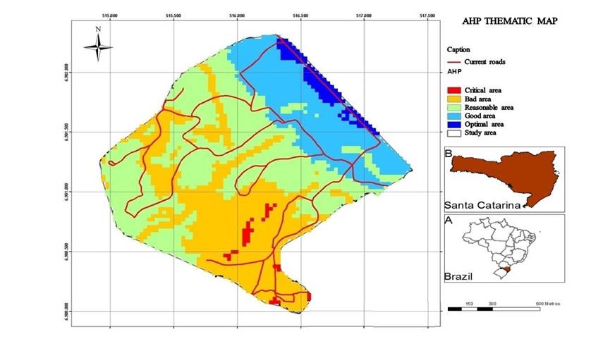
Figure 2 displays the thematic map of suitability classes, derived from the five variables and their scales detailed in Table 1. The most suitable areas for planning forest roads are concentrated in the northern and northeastern regions of the study area. These areas are characterized by low slope (S), high commercial volume (CV), and the presence of planted forests.
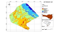
Suitability classes for the construction of forest roads according to the best scenario provided by the AHP analysis.
A comparison between existing roads and the forest road suitability map (as detailed in Table 3) reveals that very few roads are situated in critical areas (Class 1). The table further reveals that 71% of the roads are situated in regions classified as bad or reasonable, while 21% are found in good areas, and only 8% are in the optimal regions. These findings highlight opportunities for improvement in the current forest road network.
Length of the proposed forest roads under the best scenario considering permanent preservation area (PPA), slope (S), slope orientation (SO), commercial volume of timber (CV), and land cover (LC) type.
3.2 Least cost path analysis
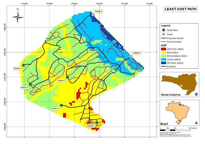
While the AHP method provided a thematic suitability map, we also selected specific start and destination points based on operational knowledge of each forest stand. These points were essential for computing the least-cost path and generating an optimized road layout, since the AHP map alone does not provide sufficient guidance for effective road network design or relocation. Figure 3 presents the existing forest road network alongside the alignment proposed by the least-cost path analysis. The existing network totals 13,455.89 m, resulting in a density of 43.34 m·ha⁻¹. In contrast, the optimized layout spans 12,133.81 m, yielding a density of 39.08 m·ha⁻¹ - a reduction of 1,322.08 m (approximately 10%). A visual comparison of the two networks reveals a clear decrease in horizontal curvature, the elimination of unnecessary dead-end segments, and a prioritization of circuit-based road patterns, all of which contribute to smoother traffic flow and improved efficiency during timber transport operations.
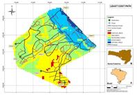
Existing road network (red lines) and the network proposed by the least-cost path tool (black lines).
The information provided by the least-cost path tool is highly valuable for planning a new forest road network. However, in cases involving consolidated roads, redefining new and alternative roads can be extremely costly. Despite this, short-term benefits are anticipated, including increased planted areas and reduced logistic costs. The integration of AHP within the GIS environment enables simultaneous analysis of multiple forest management variables, thereby reducing construction costs and minimizing environmental and social impacts. Furthermore, the least-cost path analysis allows the identification of optical routes based on the suitability classes provided by the AHP method. Given the localized nature of the results, this approach has significant potential for replication in other areas, provided similar datasets are available.
It is also worth noting that many forest companies are adopting airborne LIDAR surveys to generate detailed DTMs. The promising results reported here demonstrate the potential of the AHP approach; however, its reliability may decrease as the number of variables compared grows, which should be considered in future applications and model refinements. However, these inconsistencies can be mitigated by evaluating decisions using the CI and CR. In this study, the adopted scenario with five variables yielded a CI of 0.04 and a CR of 3.9%. As stated by Norizah and Hasmadi (2012), CR values below 10% can be considered acceptable, and the resulting criteria weights are valid for decision-making within a 5-by-5 matrix. Therefore, the AHP result of this study provides a reliable basis for optimizing the forest road network.
This research represents an applied study, executed in collaboration with a local company under a scientific cooperation agreement. The company strategically implemented the study’s findings to enhance its forest road network, capitalizing on the recent harvesting of forest stands illustrated in Figure 1. Ongoing considerations include evaluating the logistics costs associated with both the former and newly proposed road networks, assessing the effectiveness of current road maintenance practices, and establishing robust erosion control monitoring. It is pertinent to note that ecological aspects were purposefully excluded from the scope of this investigation. This decision was based on the avoidance of crossing native forest remnants and refraining from new road construction within Permanent Preservation Areas (PPAs), despite current legislation may authorize such actions in specific physiognomic stages and consolidated zones.
Instead, new roads were preferentially constructed over recently harvested forest stands, allowing for the efficient use of heavy machinery such as bulldozers, backhoe loaders, dump trucks, and motor graders. Following this, strategies were implemented for installing traffic signs, designing culverts, and employing concrete piping for drainage and other structural elements, although these are beyond the scope of this research.
Although various decision-making methods are available, the AHP method was chosen due to its well-established framework, simplicity, and ease of operational implementation, particularly for small forest companies (Kantartzzis 2023). Future studies should explore alternative approaches, such as the Analytical Network Process (ANP), which accounts for interrelations among elements (Saaty & Takizawa, 1986; Satty, 1986).
Other methods of planning forest roads have been proposed. Naderializadeh and Crowe (2018) developed an optimal road location model designed to reduce construction and transportation costs in forest operations. They generated maps using three layers: forest polygons and water bodies, a DEM of the forested landscape, and a graph of potential road vertices and arcs. Their study revealed that using a dense set of candidate roads versus a sparse set resulted in a mean reduction in transportation and construction costs of 34.34% and 6.94%, respectively. Similarly, Heinimann (2017) reviewed traditional and computer-assisted forest road network planning approaches, noting that significant advancements were made with the wider availability of DEMs, which allow surface as a 3D-grid. This aligns our findings, which identified S (derived from DTM) as one of the most critical variables in forest road planning.
Field knowledge from operational staff confirmed that the proposed alignment avoids areas historically associated with operational difficulties and follows the natural terrain in a more efficient manner than the existing network.
4. Conclusions
The study validated the integration of the Analytic Hierarchy Process (AHP) with a Geographic Information System (GIS) to generate suitability maps for constructing of forest roads. Employing AHP analysis with five variables, it was shown that Permanent Preservation Area (PPA) and Slope (S) are the most important variables to consider when planning new forest roads. When comparing the suitability map generated by the AHP with the existing road network in the study area, the study revealed that most of the current roads are not located in the most suitable areas. Specifically, 71% of the existing roads are in regions classified as “bad” or “reasonable”, while only 21% are in good areas and 8% in optimal regions. Using the least-cost path analysis based on the AHP results, the study proposed an optimized route for the road network. The road network proposed by this analysis would result in a 10% reduction in road length and density compared to the existing network. Alternative approaches, such as the Analytical Network Process (ANP), are recommended as directions for future studies.
ACKNOWLEDGEMENT
We thank the company Florestal Gateados for their availability in conducting the study and for providing the data. We also thank Santa Catarina State University and the professors who contributed to the study. The authors also want to acknowledge the Santa Catarina Research Foundation (FAPESC; 4017/2024; FAPESC; 2025TR001477 and 2025TR001812) and the Coordination for the Improvement of Higher Education Personnel (CAPES). MBS and VL thank CNPq (Process #312263/2025-2 and 311221/2025-4).
REFERENCES
-
AKAY, A.E., YILMAZ, B. Use of GIS and AHP for planning the transport of forest products. ISPRS Annals of Photogrammetry, Remote Sensing and Spatial Information Sciences, v.4, p.19-24, out. 2017. DOI: 10.5194/isprs-annals-IV-4WA-19-2017.
» https://doi.org/10.5194/isprs-annals-IV-4WA-19-2017 - AKAY, A.E.; ERDAŞ, O. Estimating Rut Depth During Skidding with a Rubber-Tired Skidder. Turkish Journal of Forestry, v. 8, p. 49-57, 2007.
-
AZARI, M., PAYDAR, A., FEIZIZADEH, B. et al. A GIS-based approach for accident hotspots mapping in mountain roads using seasonal and geometric indicators. Appl Geomat, v. 15, p. 127-139, 2023. DOI: 10.1007/s12518-023-00490-2.
» https://doi.org/10.1007/s12518-023-00490-2 -
BONAMIGO, A.; SCHIMALSKI, M.B.; SOARES, P.R.C.; LIESENBERG, V.; SOUZA, T.R.; BOESING, T.L.S.. Changes to permanent preservation areas on rural properties in the southern plateau of Santa Catarina in accordance with laws nº 4,771 and 12,651. Ciência Rural, v. 47, n. 2, 2017. DOI: 10.1590/0103-8478cr20160489.
» https://doi.org/10.1590/0103-8478cr20160489 -
BRASIL. Lei nº 12.651, de 25 de maio de 2012a. Dispõe sobre a proteção da vegetação nativa. Diário Oficial [da] República Federativa do Brasil, Brasília, DF, 28 maio, 2012. Available on: Available on: http://www.planalto.gov.br/ccivil_03/_ato2011-2014/2012/lei/l12651.htm Accessed: Jan. 20, 2025.
» http://www.planalto.gov.br/ccivil_03/_ato2011-2014/2012/lei/l12651.htm -
BRASIL. Resolução nº 466, de 12 de dezembro de 2012b. Aprova as seguintes diretrizes e normas regulamentadoras de pesquisas envolvendo seres humanos. Diário Oficial [da] República Federativa do Brasil , Brasília, 2012. Available on: Available on: https://www.gov.br/conselho-nacional-de-saude/pt-br/acesso-a-informacao/legislacao/resolucoes/2012/resolucao-no-466.pdf/view Acessed: 20 jan. 2025.
» https://www.gov.br/conselho-nacional-de-saude/pt-br/acesso-a-informacao/legislacao/resolucoes/2012/resolucao-no-466.pdf/view -
ÇALIŞKAN, E., BEDIROĞLU, S., & YILDIRIM, V. Determination forest road routes via GIS-based spatial multi-criterion decision methods. Applied Ecology and Environmental Research, v. 17, p. 759-779, 2019. https://doi.org/10.15666/aeer/1701_759779.
» https://doi.org/https://doi.org/10.15666/aeer/1701_759779 -
CASTRO, M., & De Santos-Berbel, C. Spatial analysis of geometric design consistency and road sight distance. International Journal of Geographical Information Science, v. 29, p. 2061-2074, 2015. DOI: 10.1080/13658816.2015.1037304
» https://doi.org/10.1080/13658816.2015.1037304 - CHANG, K-t. Introduction to Geographic Information Systems McGraw-Hill: New York, 6th Edition. 2012.
-
DURBACH, I. Scenario planning in the Analytic Hierarchy Process. Futures Foresight Sci., v.1, 1:e16, 2019. DOI: https://doi.org/10.1002/ffo2.16.EMBRAPA. National Soil Research Center. Brazilian system of soil classification Rio de Janeiro, Embrapa Solos. 1999.
» https://doi.org/https://doi.org/10.1002/ffo2.16.EMBRAPA -
EPAGRI. Atlas Climatológico do Estado de Santa Catarina Florianópolis, Epagri/Ciram. 2002. Available in: https://ciram.epagri.sc.gov.br/ciram_arquivos/atlasClimatologico/atlasClimatologico.pdf
» https://ciram.epagri.sc.gov.br/ciram_arquivos/atlasClimatologico/atlasClimatologico.pdf -
ESRI, Geodatabase topology rules and topology error fixes. ArcGIS Available from: < Available from: https://desktop.arcgis.com/en/arcmap/latest/manage-data/editing-topology/geodatabase-topology-rules-and-topology-error-fixes.htm >. Accessed on: 31.ago. 2024.
» https://desktop.arcgis.com/en/arcmap/latest/manage-data/editing-topology/geodatabase-topology-rules-and-topology-error-fixes.htm -
GRIGOLATO, S.; PELLEGRINI, M., CAVALLI, R. Temporal analysis of traffic loads on forest road networks. Iforest - Biogeosciences and Forestry, v. 6, n. 5, p. 255-261, 2013. DOI: 10.3832/ifor0773-006. 2013.
» https://doi.org/10.3832/ifor0773-006. 2013 -
GUMUS, S. An Evaluationof Stakeholder Perception Differences in Forest Road Valuation Factors Using the Analytic Hierarchy Process (AHP). Forests, v. 8, n. 5, p. 165, 2017. DOI: 10.3390/f8050165.
» https://doi.org/10.3390/f8050165 - HAYATI, E. et al. Application of Sensitivity Analysis in Forest Road Networks Planning and Assessment. J. Agr. Sci. Tech. v. 15, p. 781-792, 2013.
- HEINIMANN, H.R. Forest Road Network and Transportion Engineering - State and Perspectives. Croat. J. For. Eng., v. 38, p. 155-173, 2017.
-
KADI, F., YILDIRIM, F., SARALIOGLU, E. Risk analysis of forest roads using landslide susceptibility maps and generation of the optimum forest road route: a case study in Macka, Turkey. Geocarto International, v. 36, p. 1612-1629, 2019. DOI:10.1080/10106049.2019.1659424.
» https://doi.org/10.1080/10106049.2019.1659424 -
KANTARTZZIS, A. Implementation of multi-criteria evaluation for mapping the spatial variability of optimal forest road network. International Journal of Sustainable Agricultural Management and Informatics, v. 9, p. 275-293, 2023. DOI: 10.1504/IJSAMI.2023.131908.
» https://doi.org/10.1504/IJSAMI.2023.131908 -
KUCUKER, D. M. Analyzing landslide susceptibility of forest roads by analytical hierarchy process (AHP) in of forest planning unit of Turkiye. Natural Hazards, v. 121, p. 2323-2345. 2025. https://doi.org/10.1007/s11069-024-06882-w.
» https://doi.org/https://doi.org/10.1007/s11069-024-06882-w - KUNWOO, C. et al. Studies on forest road construction in mountain forestStudies on forest road construction in mountain forests (X) - landform transformation of Gujeol forest road. Journal of Research Forests of Kangwon National University, v.20, p. 54-58, 2000.
-
LABELLE, E.R. et al. Strategies to Mitigate the Effects of Soil Physical Disturbances Caused by Forest Machinery: A Comprehensive Review. Curr. Forestry Rep., v. 8, p. 20-37, 2022. DOI: 10.1007/s40725-021-00155-6
» https://doi.org/10.1007/s40725-021-00155-6 - LASCHI, A. et al. A methodological approach exploring modern techniques for planning forest road networks. Croat. J. For. Eng. , v. 37, p. 319-331. 2016.
- LASCHI, A. et al. Forest Road Planning, Construction and Maintenance to Improve Forest Fire Fighting: a Review. Croat. F. For. Eng, v. 40, p. 207-219, 2019.
- MACHADO C.C. Brazilian forestry road classification system (SIBRACEF): Development and relationship with the forestry road transport method. 1989. 188 f. Thesis (Doctorate in Forestry Sciences) - Postgraduate Course in Forestry Engineering, Federal University of Paraná. 1989.
-
MACHADO, C. C.; SILVA, E. Planning environmentally friendly forest roads. In: Proceedings of the 5th Brazilian Symposium on Forest Harvesting and Transport, Porto Seguro, Brazil, v. 1, p. 1-17, 2001. Available from: <(PDF) ENVIRONMENTALLY FRIENDLY FOREST ROAD PLANNING (Available from: researchgate.net )>. Accessed: Dec. 02, 2020.
» researchgate.net - MALINOVSKI, J. R.; PERDONCINI, W. Forest use roads Irati Forest College - GTZ. Irati, 1990.
- MALINOVSKI, R.A. Mathematical model for optimizing log transport operational costs based on road quality. 180 f. Thesis (Doctorate in Forestry Sciences) - Postgraduate Program in Forestry Engineering, Federal University of Paraná. 2010.
- MOHAMMADI SAMANI, K., HOSSEINY, S. A., LOTFALIAN, M., & NAJAFI, A. Planning road network in mountain forests using GIS and Analytic Hierarchical Process (AHP). Caspian Journal of Environmental Sciences, v. 8, p. 151-162. 2010.
-
NADERIALIZADEH, N., CROWE, A. The effect of the density of candidate roads on solutions in tactical forest planning. Canadian Journal of Forest Research, v. 48, p.679-688, 2018. DOI: 10.1139/cjfr-2017-0176.
» https://doi.org/10.1139/cjfr-2017-0176 - NAGHDI, R., MOHAMMADI LIMAEI, S., BABAPOUR, R., & ARIAMANESH, M. Designing of forest road network based on technical and economical considerations using GIS & AHP. International Journal of Applied and Natural Sciences (IJANS), v.1, p. 39-44.2012.
-
MORAIS, P.d.P. et al. Assessment of Forest Road Models in Concession Areas in the Brazilian Amazon. Forests, v. 14, p. 1388, 2023. DOI: https://doi.org/10.3390/f14071388
» https://doi.org/https://doi.org/10.3390/f14071388 - NORIZAH, K.; HASMADI, I.M. Development of Priorities and Classification for Appropriate Allocation of Forest Roads using Analytical Hierarchy Process (AHP) in Peninsular Malaysia. Sains Malásia, v. 41, n. 10, p. 1177-1185, 2012.
-
OLIVEIRA FILHO, P.C. et al. Determination of the optimal transport route with the aid of a geographic information system. Ciência Florestal, v. 15, p. 403-409, 2005. DOI: 10.5902/198050981877.
» https://doi.org/10.5902/198050981877 -
PANDOLFO, C. et al. Climatological atlas of the State of Santa Catarina Florianópolis: EPAGRI, 2002. Available ON: Available ON: https://ciram.epagri.sc.gov.br/index.php/solucoes/climatologia/ Accessed on: 31 ago. 2002.
» https://ciram.epagri.sc.gov.br/index.php/solucoes/climatologia/ -
PARSAKHOO, A. Metric measures for optimizing forest road network alternatives in GIS-based programs. Forest Science and Technology, v. 12, n. 3, p. 153-161, 2016. DOI: 10.1080/21580103.2016.1141718.
» https://doi.org/10.1080/21580103.2016.1141718 - PARSAKHOO, A., LOFTAN. M. HOSSEINI, S. A. Forest roads planning and construction in Iranian forestry. Journal of Civil Engineering and Construction Technology, v.1, p.14-18, 2010.
-
PIAZZA, G. A. Object-oriented and pixel-based classification approaches for classifying tropical successional stages using high-spatial resolution airborne imagery. GIScience & Remote Sensing, v.53, p. 206-226, 2016. DOI: 10.1080/15481603.2015.1130589.
» https://doi.org/10.1080/15481603.2015.1130589 -
PINGEL, T.J. Slope modeling as a contributor to route selection in mountainous areas. Cartography and Geographic Information Science, v.37, p. 137-148, 2010. DOI: 10.1559/152304010791232163.
» https://doi.org/10.1559/152304010791232163 -
SAATY, T.L. Axiomatic foundation of the analytical hierarchy process. Management Science, v. 32, p. 841-855, 1986. DOI:10.1287/mnsc.32.7.841.
» https://doi.org/10.1287/mnsc.32.7.841 -
SAATY, T.L.; TAKIZAWA, M. Dependence and independence: From linear hierarchies to nonlinear networks. European Journal of Operational Research, v. 26, p. 229-237, 1986. DOI: 10.1016/0377-2217(86)90184-0
» https://doi.org/10.1016/0377-2217(86)90184-0 -
SAATY, R.W. The Analytic hierarchy process-what it is and how it is used. Mathematical Modelling, v. 9, p. 161-176, 1987. DOI: 10.1016/0270-0255(87)90473-8
» https://doi.org/10.1016/0270-0255(87)90473-8 -
SAATY, T.L. How to make a decision: The analytic hierarchy process. Eur. J. Oper. Res., v. 48, p. 9-26, 1990. DOI: 10.1016/0377-2217(90)90057-I
» https://doi.org/10.1016/0377-2217(90)90057-I -
SAATY, T. L. The Analytic Hierarchy and Analytic Network Measurement Processes: Applications to Decisions under Risk. European journal of pure and applied mathematics, v. 1, p. 122-196, 2008a. DOI: 10.29020/nybg.ejpam.v1i1.6
» https://doi.org/10.29020/nybg.ejpam.v1i1.6 -
SAATY, T.L. Decision making with the analytic hierarchy process. Int. J. Serv. Sci., v.1, p. 83-98, 2008b. DOI: 10.1504/IJSSci.2008.017590
» https://doi.org/10.1504/IJSSci.2008.017590 - SAMANI, K.M. et al. Planning Road network in mountain forests using GIS and Analytic Hierarchical Process (AHP). Caspian J. Env. Sci., v. 8, p. 151-162, 2010.
- SHIBA, M. Analytic hierarchy process (AHP) based multi attribute benefit structure analysis of road network system in mountainous rural areas of Japan. Journal of Forest Engineering, v. 7, p.14-50, 1995.
-
SILVA, B. G. et al. Pathways affect the structure and composition of vegetation in the Atlantic Forest in southeastern Brazil. Acta Botânica Brasileira, v. 31, n. 1, p. 108-119. 2017. DOI: 10.1590/0102-33062016abb0402.
» https://doi.org/10.1590/0102-33062016abb0402 - SOTHE, C.; SCHIMALSKI, M.B.; LIESENBERG, V.; ALMEIDA, C.M.; SOUZA, C.F.; SOUZA, J.BApplying data mining techniques to the classification of successional forest stages mixed shade tolerantforest environments. Scientia Forestalis, v. 44, p. 863-873, 2016.
-
SOUZA, F.L. et al. Optimal and acceptable density of roads in pine harvesting in the short log and whole tree system. Scientia Forestalis , v. 46, p. 189-198, 2018. DOI: 10.18671/scifor.v46n118.05. 2018.
» https://doi.org/10.18671/scifor.v46n118.05. 2018 - SOUZA, F. L. Multi-criteria analysis for defining the layout of forest roads. 2019. 30p. TCC Federal University of Paraná, Curitiba, 2019.
- STRAKA, T. J. MARTIN, T. A. An Evaluation of Stakeholder Perception Differences in Forest Road Assessment Factors Using the Analytic Hierarchy Process (AHP). Forests, v. 8, p. 165, 2017.
- TRIANTAPHYLLAOU, E.; MANN, S.H. Using the analytic hierarchy process for decision making in engineering applications: Some challenges. International Journal of Industrial Engineering: Applications and Practices, v. 2, p. 35-44, 1995.
The datasets generated during and/or analyzed during the current study are available from the corresponding author on reasonable request.