
 Spatial Lead Distribution in Mangifera indica and Syzygium malaccense in a Medium-Sized City, Colombia
Abstract:
Uncontrolled urban development driven by forced migration has heightened the need for strategies to mitigate food security in Latin America. This study aims to characterize the presence and spatial distribution of lead (Pb) concentrations in fruit-bearing tree species along public roads in Neiva, Colombia, a medium-sized city. A comprehensive census identified Mangifera indica and Syzygium malaccense as the most prevalent species. Fruit samples were collected and analyzed according to FAO standards. Spatial interpolation and Kriging methods were employed to map lead concentrations across the urban landscape. Results revealed detectable levels of lead in all samples, with five samples exceeding the permissible limit of 0.1 mg/kg. The highest concentrations were observed in industrial areas, suggesting significant contamination from vehicular and industrial activities. These findings underscore the importance of urban agroforestry strategies in areas with lower contamination levels and highlight the need for further research to identify safer urban agriculture zones.
Keywords::
Ecosystem Services; Edible landscape; Heavy metal; Sustainability; Urban food forest
Resumo
O desenvolvimento urbano descontrolado e o deslocamento populacional aumentaram a necessidade de desenvolver estratégias que mitiguem a insegurança alimentar na América Latina. Esta pesquisa caracterizou a presença e a distribuição espacial de concentrações de chumbo (Pb) em espécies de árvores frutíferas nas vias públicas de Neiva, Colômbia. Um censo identificou Mangifera indica e Syzygium malaccense como as espécies mais prevalentes. Amostras de frutas foram coletadas e analisadas de acordo com padrões internacionais. Métodos de interpolação espacial e Kriging foram utilizados para mapear as concentrações de chumbo no ambiente urbano. Foram detectados níveis de chumbo em todas as amostras, com cinco delas excedendo o limite permissível de 0,1 mg/kg. As concentrações mais elevadas foram observadas em áreas industriais. Esses achados destacam a importância de estabelecer estratégias de agroflorestação urbana em áreas com baixos níveis de contaminação e indicam a necessidade de futuras pesquisas que zonifiquem a agricultura urbana.
Palavras-chave:
Floresta Urbana de Alimentos; Metal pesado; Paisagem Comestível; Serviços Ecossistêmicos; Sustentabilidade
Resumen
El desarrollo urbano descontrolado y el desplazamiento poblacional, ha incrementado la necesidad de diseñar estrategias que mitiguen la seguridad alimentaria en América Latina. Esta investigación caracterizó la presencia y distribución espacial de concentraciones de plomo (Pb) en especies de árboles frutales en las vías públicas en Neiva, Colombia. Se realizó un censo que identificó a Mangifera indica y Syzygium malaccense como las especies más prevalentes. Se recolectaron y analizaron muestras de frutas según estándares internacionales. Se emplearon métodos de interpolación espacial y Kriging para mapear las concentraciones de plomo en el paisaje urbano. Se encontraron niveles de plomo en todas las muestras, con cinco superando el límite permisible de 0.1 mg/kg. Las mayores concentraciones se observaron en áreas industriales. Estos hallazgos destacan la importancia de establecer estrategias de agroforestería urbana en áreas con bajos niveles de contaminación y se identifica la necesidad de futuras investigaciones que zonifiquen la agricultura urbana.
Palavras clave:
Bosques alimentarios urbanos; Metales pesados; Paisajes comestibles; Servicios Ecosistemicos; Sostenibilidad
Introduction
In urban environments, heavy metals primarily originate from anthropogenic sources. Vehicular traffic, industrial plants, and incinerators release metals into the atmosphere, which are then deposited on the ground and absorbed by plant species (SAWIDIS et al., 2011). The degree of metal absorption depends on various factors, including the specific plant species, type of pollutant, and its concentration (ALAHABADI et al., 2017). Among the most studied metals due to their toxicity and prevalence are mercury (Hg), arsenic (As), and lead (Pb) (ALLOWAY, 2013). Monitoring these contaminants in urban areas is costly and often unreliable, leading to a preference for assessing the response of living organisms, such as trees, which are effective bioindicators of atmospheric pollution (BOQUETE et al., 2014).
Urban food forestry (UFF) has gained significant attention as a strategy to support the Sustainable Development Goals (SDGs), particularly the Zero Hunger initiative. Over the past 20 years, research in this field has grown at a rate of 13.8% (VALDERRAMA et al., 2023), by enhancing urban green spaces and improving air quality (DOUGLAS; IRGA; TORPY, 2019; WARD et al., 2015; ZUPANCIC; WESTMACOTT; BULTHUIS, 2015). Despite its benefits, UFF faces challenges, particularly regarding the risk of heavy metal contamination in urban areas. Plants growing in these environments are exposed to high pollutant loads, which can lead to the bioaccumulation of harmful substances in edible fruits (MEHARG, 2016; SÄUMEL et al., 2012). Despite the growing interest, edible tree-based landscaping remains limited, and no standard guidelines for producing healthy fruits in urban areas are available (GORI; FERRINI; FINI, 2019).
Recent advancements in geostatistics have significantly enhanced environmental contamination monitoring, particularly through the application of kriging for spatial analysis and prediction. Kriging remains a prominent technique, providing optimal linear unbiased predictions for unsampled locations, which is crucial for accurate environmental assessments (OLIVER; WEBSTER, 2014; SRIVASTAVA, 2013). Nonlinear kriging methods, such as lognormal and indicator kriging, are particularly effective for addressing non-Gaussian data trends (ROUHANI, 1996). Geostatistical modeling has also proven instrumental in assessing soil pollution based on atmospheric deposition, allowing for precise predictions of contamination levels with minimal field sampling, thereby reducing costs and improving efficiency (BORKOWSKI; KWIATKOWSKA-MALINA, 2017; HENSHAW et al., 2004). Furthermore, the integration of geographic information systems (GIS) with kriging techniques has refined the accuracy of spatial distribution assessments in urban environments, making it an indispensable tool for characterizing contamination in areas impacted by industrial activities (CHENG et al., 2009; NICKEL et al., 2017; WANG; XIE; LI, 2015).
Similar approaches have been applied in various contexts, such as the use of factorial kriging combined with stepwise regression to identify environmental factors influencing heavy metal distribution in soils in Rizhao, China, where kriging revealed multi-scale variability and aided in environmental assessment (LV et al., 2013). Another study utilized kriging to analyze the spatial dependence of soil properties in brackish marsh areas, providing critical insights for land management and agricultural productivity improvement (SIGUA; HUDNALL, 2008). Additionally, regression-kriging has been applied to enhance the prediction accuracy of soil properties in precision agriculture, integrating spatial correlation from regression residuals to significantly improve soil characterization (YUFENG GE et al., 2007). These examples underscore the versatility of kriging in environmental and agricultural applications, demonstrating its value in predicting and managing contamination.
Considering the growing interest in edible landscapes associated with urban forestry, geostatistics, particularly kriging, holds significant potential for addressing knowledge gaps related to the identification, localization, and prediction of optimal urban cultivation sites. Currently, there is a notable lack of research utilizing this technology to predict and establish potential areas for urban agriculture. For instance, studies in large cities like New York have evaluated production capacities and nutritional properties of various species ‘‘berries and walnut’’ (BUNGE et al., 2019). Meanwhile, investigations in Berlin have determined Pb and Cd content in urban fruits (VON HOFFEN; SÄUMEL, 2014). In Chelyabinsk, research has shown that metals and metalloids in fruits pose no health risk if properly washed (KRUPNOVA et al., 2021). Moreover, studies in intermediate cities in the Congo identified the potential for fruit generation in homes (USENI et al., 2021). Similar research in Seville, Palermo, Al Ain, and Kastamonu has analyzed metal concentrations in various urban fruits, linking contamination levels to specific areas like orange (OLIVA; VALDÉS, 2003), date palm fruits (AHMED; KAUR; HASSAN, 2022), and apple trees (SEVIK et al., 2020). Thus, the application of advanced geostatistical methods can significantly enhance environmental monitoring and decision-making processes in urban agriculture contexts.
In Latin America, medium-sized cities (populations between 50,000 and 1 million) serve as critical connectors between rural and urban areas, representing about 20% of the world’s population(IGLESIAS, 2016). These cities, such as Neiva, Colombia, face unique challenges and opportunities in implementing urban forestry initiatives to be a strategy to bridge the gap between food production and consumption sites (CASTRO et al., 2018). Given that approximately 90% of the population in Latin America and the Caribbean is projected to live in urban areas by 2050, addressing food security through urban agriculture becomes increasingly vital(UNITED NATIONS; DEPARTMENT OF ECONOMIC AND SOCIAL AFFAIRS; POPULATION DIVISION, 2019). This study aims to characterize the presence and spatial distribution of lead concentrations in fruit species along public roads in Neiva to verify if the contaminant levels exceed the permissible limits in food.
1. Materials and Methods
1.1 Selection of Fruits and Sampling Area
The urban area of Neiva, Colombia, was systematically divided into ten zones, each representing different levels of industrial activity and vehicular traffic (figure 1). Zones 6 and 9 were identified as areas with small industrial operations, while the remaining zones were primarily residential with mixed small businesses. Given the lack of a formal inventory of fruit-bearing trees by local authorities, an initial identification of species was conducted based on literature from countries with similar environmental conditions(DOUGLAS; IRGA; TORPY, 2019). The study targeted fruit trees in public spaces such as medians, sidewalks, and parks, particularly those most exposed to direct pollution from vehicular emissions and industrial discharges.

1.2 Sample Collection
Fruit samples were collected using a stratified random sampling method, targeting the two most predominant species, Mangifera indica and Syzygium malaccense, identified in the initial census. This method was chosen to ensure that samples were representative of the different environmental conditions across the study area. The stratification was based on factors such as proximity to industrial zones, traffic density, and the level of urbanization. Each selected fruit was evaluated for ripeness, color, and position on the tree to ensure consistency in the samples. To minimize external contamination, all samples were collected using sterilized gloves and tools, and each fruit was placed in pre-labeled, hermetically sealed polyethylene bags. The bags were immediately stored in portable coolers at a temperature of 4°C to prevent any biochemical changes during transportation. The samples were transported to the laboratory within 4 hours of collection, maintaining the cold chain throughout the process to preserve the integrity of the samples for subsequent analysis.
1.3 Laboratory Analysis
The laboratory analysis adhered to the international protocols established by the Official Analytical Collaboration Association (AOAC) for both sample preparation and the quantification of lead (Pb) concentrations. Initially, each fruit sample was thoroughly washed with deionized water to remove any surface contaminants, including dust and particulate matter. After air-drying, the samples were manually separated into pulp and seeds using sterilized stainless-steel instruments. The pulp was cut into small, uniform pieces and placed in a convection oven at 100°C for 24 hours to ensure complete dehydration. Once dried, the samples were ground into a fine, homogeneous powder using an agate mortar and pestle, ensuring that no metallic contamination occurred during the process. For metal extraction, a microwave-assisted acid digestion was conducted using a mixture of concentrated nitric acid (HNO3) and hydrogen peroxide (H2O2) in a closed-vessel system, as per EPA Method 3052. The digested samples were then analyzed using atomic absorption spectroscopy (AAS) at a wavelength of 217.0 nm. Calibration standards were prepared using certified reference materials, and the detection limit for Pb was set at 3.0 µg/L. Quality control measures included the use of blanks, duplicates, and spiked samples to ensure the accuracy and precision of the measurements
1.4 Statistical Analysis
Descriptive statistics were first employed to summarize the central tendencies and dispersions of the lead (Pb) concentration data across the collected fruit samples. The normality of the Pb concentration distribution was rigorously assessed using the Shapiro-Wilk test, while homogeneity of variances was confirmed through Levene’s and Bartlett’s tests. A two-sample Student’s t-test was performed to compare Pb concentrations between Mangifera indica and Syzygium malaccense, with assumptions of equal variances validated by the preliminary tests.
For spatial analysis, a comprehensive geostatistical approach was adopted. Heat maps were developed to visualize the density of fruit-bearing trees and the spatial distribution of Pb concentrations across Neiva. These heat maps were created using kernel density estimation, which was informed by both the inventory of tree species and official data on urban heat retention. The identification of urban heat islands was critical to understanding the correlation between high-temperature zones and elevated Pb levels. Ordinary kriging was employed for spatial interpolation of Pb concentrations across the study area, providing predictions for unsampled locations. The kriging model utilized a spherical semivariogram model, which was selected based on cross-validation results, to ensure the best fit for the spatial structure of the data. Error estimation maps were also generated to identify areas with significant uncertainty in Pb concentration predictions, guiding future monitoring efforts.
2. Results
2.1 Identification of fruit trees on main roads
During the initial exploratory phase conducted in 2019, a total of 2,025 fruit-bearing trees were identified across Neiva’s main roads. The most prevalent species were Syzygium malaccense with 962 trees (47.5%) and Mangifera indica with 717 trees (35.4%). These species were predominantly located in zones with higher exposure to vehicular traffic and industrial activities, correlating with areas identified as potential hotspots for lead contamination (Table 1).
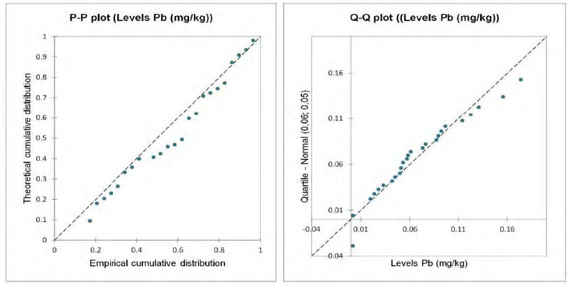
Lead (Pb) levels were detected in all 29 fruit samples analyzed, with 16 samples from Mangifera indica and 13 from Syzygium malaccense. The median Pb concentration for Mangifera indica was 0.075 mg/kg [Interquartile range: 0.093 - 0.052], while Syzygium malaccense exhibited a lower median concentration of 0.024 mg/kg [Interquartile range: 0.051 - 0.002]. These values suggest that Mangifera indica may have a higher tendency to accumulate lead compared to Syzygium malaccense (Figure 2).

The Shapiro-Wilk test indicated no significant deviation from normality for Pb levels (W = 0.941, p = 0.104), validating the use of parametric tests. Levene’s test (F = 0.054, p = 0.818) and Bartlett’s test (χ² = 0.090, p = 0.765) confirmed the homogeneity of variances between the two species. Consequently, the data supports the application of a two-sample t-test for comparing Pb concentrations between Mangifera indica and Syzygium malaccense.
The Student’s t-test revealed a statistically significant difference in lead concentrations between Mangifera indica and Syzygium malaccense (p < 0.05). Mangifera indica displayed a higher mean Pb concentration (0.080 mg/kg ± 0.041) compared to Syzygium malaccense (0.039 mg/kg ± 0.044). These results suggest that Mangifera indica may be more prone to absorbing lead, potentially due to its physiological characteristics and the microenvironments in which it is commonly found(PRASETIA et al., 2018).
The ANOVA results indicated no statistically significant differences in lead concentrations across the different urban zones (F = 0.497, p = 0.738). Despite this, the highest concentrations of lead were consistently found in zones with higher industrial activity, particularly zones 6, 9, and 10. This spatial distribution aligns with previous studies that link elevated Pb levels to localized sources of contamination such as industrial emissions and vehicular traffic(KRUPNOVA et al., 2021; SEVIK et al., 2020). Heat maps created using kriging models further illustrated these patterns, highlighting the areas with the highest contamination risks.
When compared to the international food safety standard CODEX STAN 193-1995, which sets a permissible lead limit of 0.1 mg/kg in food, five samples exceeded this threshold. These included three samples from Syzygium malaccense in zones 2 and 10, with concentrations of 0.131 mg/kg, 0.123 mg/kg, and 0.5095 mg/kg, respectively. Additionally, two samples from Mangifera indica in zones 2, 6, and 9 exhibited concentrations of 0.174 mg/kg, 0.114 mg/kg, and 0.156 mg/kg, respectively. These findings highlight the potential health risks associated with consuming fruits from these areas and underscore the need for continuous environmental monitoring (CODEX ALIMENTARIUS COMMISSION, 1995).
2.2 Environmental geostatistics
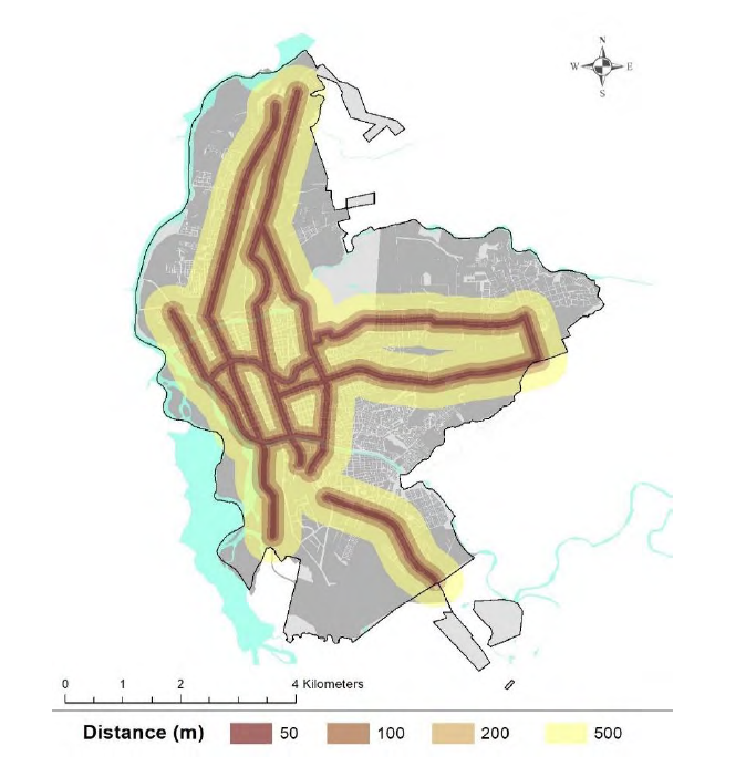
Figure 3 illustrates the distribution of urban heat clusters in Neiva, developed by integrating the inventory of identified fruit tree species with official data sources on heat retention across the city. The heat map reveals that the highest concentrations of urban heat are located in areas with dense industrial activity and heavy vehicular traffic, particularly in the southern zones of the city. These areas, characterized by a lack of green spaces and a prevalence of impervious surfaces, show a significant correlation between reduced vegetation cover and increased heat retention. The identification of these heat clusters is crucial for urban planning, as it highlights the need for targeted interventions to enhance urban greening and reduce heat stress in these vulnerable zones.

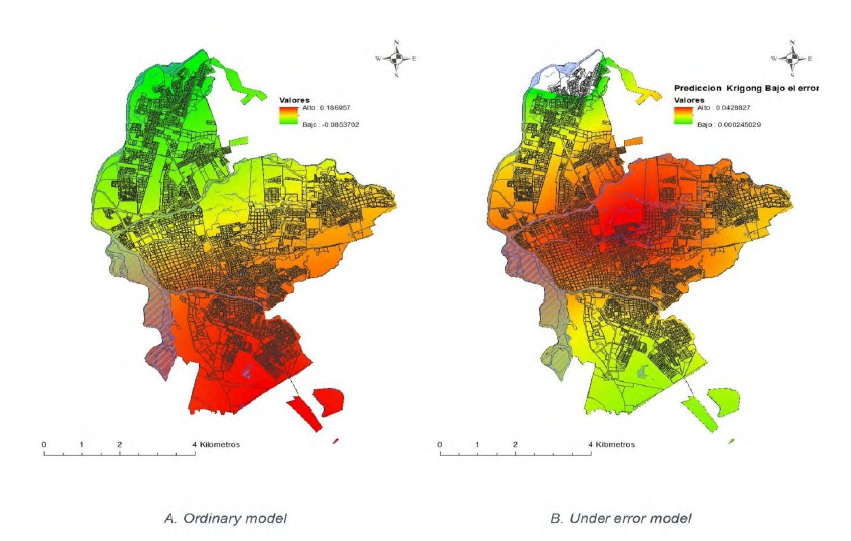
The first image(A) in Figure 4 presents the predicted spatial distribution of lead (Pb) concentrations across Neiva, generated using the ordinary kriging method. This geostatistical approach allows for the estimation of lead levels in unsampled areas by leveraging the spatial correlation of data collected from sampled locations. The map reveals that the highest predicted lead concentrations are concentrated in the southern industrial zones of the city, where intense industrial activity and high traffic volumes are predominant. These findings align with the observed environmental conditions and underscore the influence of local industrial and vehicular emissions on urban lead contamination.
The second image (B), incorporates error estimation into the kriging model, highlighting areas of uncertainty in the predicted lead concentrations. The error map identifies zones with significant prediction variability, particularly in the city center and eastern regions, which may be attributed to inconsistent data or variable sources of contamination, such as fluctuating traffic patterns and mixed land use. These areas marked by higher uncertainty require focused environmental monitoring and more frequent sampling to refine the predictive accuracy of the contamination models. This analysis not only reinforces the necessity for localized monitoring but also aids in identifying critical zones where public health interventions should be prioritized.
3. Discussion
The diversity of fruit tree species identified in Neiva reflects a significant urban effort toward utilizing green spaces for both beautification and food production. The dominance of Mangifera indica and the Syzygium Malaccense indicates these species’ adaptability to the local urban environment, including their resilience to various pollutants and urban stressors(TODOROV; BOGSAN, 2016). However, the presence of lead (Pb) contamination, particularly in Mangifera indica, suggests that despite the benefits of urban agroforestry, there are significant environmental health risks that must be managed. These findings align with previous studies highlighting the potential for heavy metal accumulation in urban fruit trees, particularly in areas with high vehicular and industrial activities (AHMED; KAUR; HASSAN, 2022; SÄUMEL et al., 2012).
The higher concentrations of lead in Mangifera indica compared to Syzygium malaccense may be attributed to several factors, including differences in species-specific physiology and the microenvironments in which these trees grow(ALAHABADI et al., 2017; PRASETIA et al., 2018). Mangifera indica trees are known to have a greater surface area of leaves and bark, which may enhance their ability to absorb and accumulate airborne pollutants (SAWIDIS et al., 2011). This observation is consistent with studies conducted in other urban environments, where evergreen species, particularly those with broad leaves, have shown higher levels of heavy metal accumulation(VITTORI ANTISARI et al., 2015). The significant lead concentrations detected in this study underline the need for targeted strategies to mitigate exposure risks, particularly in areas with high pollutant loads.
The findings indicate that 17% of the analyzed fruit samples had lead concentrations exceeding the permissible established in the CODEX STAN 193-1995 (FAO; WHO, 2019). These exceedances were primarily associated with trees located in areas of high vehicular traffic and industrial activity, corroborating studies that identify traffic emissions and industrial discharges as significant contributors to urban heavy metal contamination (SEVIK et al., 2020; WU et al., 2015). This highlights the need for continuous environmental monitoring and the development of urban agroforestry practices that prioritize food safety. It is also important to consider the potential variability in contamination levels throughout different seasons, as atmospheric conditions and pollutant dispersion can significantly influence the bioaccumulation of heavy metals(LEVIN et al., 2020).
The geostatistical analysis revealed significant spatial variability in lead concentrations across Neiva, with the highest levels observed in the southern industrial zones and areas with dense traffic. These results align with previous research that has demonstrated the localized nature of heavy metal contamination in urban areas(CHENG et al., 2009; WANG; XIE; LI, 2015). The kriging model’s error analysis further identified zones with considerable uncertainty, underscoring the need for targeted environmental monitoring in these areas. These findings suggest that urban planners should implement localized intervention strategies that focus on high-risk zones to effectively manage and mitigate lead exposure in urban agroforestry contexts.
The results of this study have important implications for urban agroforestry and urban planning. The significant levels of lead contamination detected in specific urban areas highlight the potential health risks associated with consuming fruits grown in these environments. Urban planners and policymakers need to consider these findings when developing urban greening initiatives, ensuring that food safety is a priority. Strategies such as regular monitoring, the selection of less susceptible species, and the implementation of buffer zones around high-risk areas can help mitigate the risks associated with heavy metal contamination in urban agroforestry (MCCLINTOCK, 2010; ZUPANCIC; WESTMACOTT; BULTHUIS, 2015).
Conclusions
This study has demonstrated that urban areas in medium-sized cities, such as Neiva, Colombia, have significant potential for food production through urban agroforestry. However, the findings highlight a critical challenge: the presence of lead (Pb) contamination in fruit-bearing trees, particularly Mangifera indica and Syzygium malaccense. Approximately 17% of the analyzed samples exceeded the permissible limits for lead concentration in food, with the highest levels detected in industrial zones and areas with dense vehicular traffic. These results underscore the need for targeted environmental interventions and stricter monitoring to ensure the safety of urban-grown fruits.
The detection of elevated lead levels in certain urban zones raises significant public health concerns. Consuming fruits contaminated with lead poses a risk, particularly for vulnerable populations. As urban agriculture continues to expand, it is essential to implement strategies that minimize exposure to contaminants. This includes selecting tree species that are less prone to absorbing heavy metals, establishing buffer zones between high-risk areas and urban agriculture sites, and conducting regular soil and air quality assessments. These measures are crucial to safeguard the health of urban residents and to ensure the sustainability of urban agroforestry initiatives.
The findings of this study highlight the need for urban planners to incorporate food safety considerations into the development of green spaces. This includes prioritizing areas with low contamination levels for urban agroforestry projects and integrating environmental monitoring into urban planning processes. Future research should focus on exploring the bioaccumulation mechanisms of other contaminants in various urban fruit species, as well as the long-term impacts of urban pollution on food safety. Longitudinal studies are also recommended to monitor changes in contaminant levels over time, which will be essential for developing sustainable urban agriculture practices.
In conclusion, while urban agroforestry offers promising benefits for medium-sized cities, particularly in terms of food security and urban greening, it must be approached with caution. Ensuring that urban-grown food is safe for consumption requires a collaborative effort between urban planners, environmental scientists, and public health officials. By integrating environmental monitoring and risk management into urban agriculture practices, cities can effectively harness the benefits of agroforestry while protecting public health.
Acknowledgments
The authors thank the Complutense University of Madrid and the Manizales University for their support in carrying out this research, the latter specifically through the Business Doctoral program.
References
- AHMED, Z. F. R.; KAUR, N.; HASSAN, F. E. Ornamental Date Palm and Sidr Trees: Fruit Elements Composition and Concerns Regarding Consumption. International Journal of Fruit Science, v. 22, n. 1, p. 17-34, 2022.
- ALAHABADI, A. et al. A comparative study on capability of different tree species in accumulating heavy metals from soil and ambient air. Chemosphere, v. 172, p. 459-467, 2017.
- ALLOWAY, B. J. Sources of Heavy Metals and Metalloids in Soils. Em: [s.l: s.n.]. p. 11-50.
- BOQUETE, M. T. et al. Effect of age on the heavy metal concentration in segments of Pseudoscleropodium purum and the biomonitoring of atmospheric deposition of metals. Atmospheric Environment, v. 86, p. 28-34, 2014.
- BORKOWSKI, A. SZ.; KWIATKOWSKA-MALINA, J. Geostatistical modelling as an assessment tool of soil pollution based on deposition from atmospheric air. Geosciences Journal, v. 21, n. 4, p. 645-653, 1 ago. 2017.
- BUNGE, A. et al. Urban foraging for food security and sovereignty: Quantifying edible forest yield in Syracuse, New York using four common fruit- and nut-producing street tree species. Journal of Urban Ecology, v. 5, n. 1, 2019.
- CASTRO, J. et al. “edible” urban forests as part of inclusive, sustainable cities. Unasylva, v. 69, n. 250, p. 59-65, 2018.
- CHENG, W. et al. Integrating classification and regression tree (CART) with GIS for assessment of heavy metals pollution. Environmental Monitoring and Assessment, v. 158, n. 1-4, p. 419-431, 13 nov. 2009.
-
CODEX ALIMENTARIUS COMMISSION. General standard for contaminants and toxins in food and feed (CXS 193-1995). Roma: [s.n.]. Disponível em: <https://www.fao.org/fao-who-codexalimentarius/codex-texts/list-standards/en/>. Acesso em: 24 ago. 2024.
» https://www.fao.org/fao-who-codexalimentarius/codex-texts/list-standards/en - DOUGLAS, A. N. J.; IRGA, P. J.; TORPY, F. R. Determining broad scale associations between air pollutants and urban forestry: A novel multifaceted methodological approach *. Environmental Pollution, v. 247, p. 474-481, 2019.
-
FAO; WHO. GENERAL STANDARD FOR CONTAMINANTS AND TOXINS IN FOOD AND FEED, CXS 193-1995. [s.l: s.n.]. Disponível em: <http://www.fao.org/fao-who-codexalimentarius/sh-proxy/es/?lnk=1&url=https%25253A%25252F%25>. Acesso em: 11 jul. 2020.
» http://www.fao.org/fao-who-codexalimentarius/sh-proxy/es/?lnk=1&url=https%25253A%25252F%25 - GORI, A.; FERRINI, F.; FINI, A. Growing healthy food under heavy metal pollution load: Overview and major challenges of tree based edible landscapes. Urban Forestry & Urban Greening, v. 38, p. 403-406, fev. 2019.
- HENSHAW, S. L. et al. Geostatistics and GIS: Tools for Characterizing Environmental Contamination. Journal of Medical Systems, v. 28, n. 4, p. 335-348, ago. 2004.
- IGLESIAS, B. M. Intermediary cities in the territorial integration of the Global South. Revista CIDOB d’Afers Internacionals, v. 2016, n. 114, p. 109-132, 2016.
- KRUPNOVA, T. G. et al. Apple trees as a possible monitor and phytoremediator of urban and industrial areas in Chelyabinsk, Russian Federation. Biodiversitas, v. 22, n. 7, p. 2824-2828, 2021.
- LEVIN, R. et al. Lead seasonality in humans, animals, and the natural environment. Environmental Research, v. 180, p. 108797, 2020.
- LV, J. et al. Factorial kriging and stepwise regression approach to identify environmental factors influencing spatial multi-scale variability of heavy metals in soils. Journal of Hazardous Materials, v. 261, p. 387-397, out. 2013.
- MCCLINTOCK, N. Why farm the city? Theorizing urban agriculture through a lens of metabolic rift. Cambridge Journal of Regions, Economy and Society, v. 3, n. 2, p. 191-207, 1 jul. 2010.
- MEHARG, A. A. Perspective: City farming needs monitoring. Nature, v. 531, n. 7594, p. S60-S60, 16 mar. 2016.
- NICKEL, S. et al. Modelling and mapping heavy metal and nitrogen concentrations in moss in 2010 throughout Europe by applying Random Forests models. Atmospheric Environment, v. 156, p. 146-159, maio 2017.
- OLIVA, S. R.; VALDÉS, B. Metal concentrations in Seville orange (Citrus aurantium) fruits from Seville (Spain) and Palermo (Italy). Annales Botanici Fennici, v. 40, n. 5, p. 339-344, 2003.
- OLIVER, M. A.; WEBSTER, R. A tutorial guide to geostatistics: Computing and modelling variograms and kriging. CATENA, v. 113, p. 56-69, fev. 2014.
- PRASETIA, H. et al. Mangifera indica as Bioindicator of Mercury Atmospheric Contamination in an ASGM Area in North Gorontalo Regency, Indonesia. Geosciences, v. 8, n. 1, p. 31, jan. 2018.
- ROUHANI, S. Geostatistical Estimation: Kriging. Em: Geostatistics for Environmental and Geotechnical Applications. [s.l.] ASTM International100 Barr Harbor Drive, PO Box C700, West Conshohocken, PA 19428-2959, 1996. p. 20-31.
- SÄUMEL, I. et al. How healthy is urban horticulture in high traffic areas? Trace metal concentrations in vegetable crops from plantings within inner city neighbourhoods in Berlin, Germany. Environmental Pollution, v. 165, p. 124-132, 2012.
- SAWIDIS, T. et al. Trees as bioindicator of heavy metal pollution in three European cities. Environmental Pollution, v. 159, n. 12, p. 3560-3570, dez. 2011.
- SEVIK, H. et al. Changes in heavy metal accumulation in some edible landscape plants depending on traffic density. Environmental Monitoring and Assessment, v. 192, n. 2, 2020.
- SIGUA, G. C.; HUDNALL, W. H. Kriging analysis of soil properties. Journal of Soils and Sediments, v. 8, n. 3, p. 193-202, 3 jun. 2008.
- SRIVASTAVA, R. M. Geostatistics: A toolkit for data analysis, spatial prediction and risk management in the coal industry. International Journal of Coal Geology, v. 112, p. 2-13, jun. 2013.
- TODOROV, S. D.; BOGSAN, C. S. Tropical Fruits-- From Cultivation to Consumption and Health Benefits : Guava and Mango. New York: Nova Science Publishers, Inc, 2016.
- UNITED NATIONS; DEPARTMENT OF ECONOMIC AND SOCIAL AFFAIRS; POPULATION DIVISION. World Urbanization Prospects 2018: Highlights. New York: UN, 2019.
- USENI, Y. S. et al. Diversity, use and management of household-located fruit trees in two rapidly developing towns in Southeastern D.R. Congo. Urban Forestry and Urban Greening, v. 63, 2021.
- VALDERRAMA, C. FELIPE et al. Análisis de la agroforestería urbana: una revisión sistemática y análisis bibliométrico. Colombia forestal, v. 26, n. 2, p. 77-91, 1 jul. 2023.
- VITTORI ANTISARI, L. et al. Uptake and translocation of metals and nutrients in tomato grown in soil polluted with metal oxide (CeO 2 , Fe 3 O 4 , SnO 2 , TiO 2 ) or metallic (Ag, Co, Ni) engineered nanoparticles. Environmental Science and Pollution Research, v. 22, n. 3, p. 1841-1853, 2015.
- VON HOFFEN, L. P.; SÄUMEL, I. Orchards for edible cities: Cadmium and lead content in nuts, berries, pome and stone fruits harvested within the inner city neighbourhoods in Berlin, Germany. Ecotoxicology and Environmental Safety, v. 101, n. 1, p. 233-239, 2014.
- WANG, Q.; XIE, Z.; LI, F. Using ensemble models to identify and apportion heavy metal pollution sources in agricultural soils on a local scale. Environmental Pollution, v. 206, p. 227-235, nov. 2015.
- WARD, H. C. et al. Effects of urban density on carbon dioxide exchanges: Observations of dense urban, suburban and woodland areas of southern England. Environmental Pollution, v. 198, p. 186-200, 2015.
- WU, S. et al. Levels and health risk assessments of heavy metals in urban soils in Dongguan, China. Journal of Geochemical Exploration, v. 148, p. 71-78, 2015.
- YUFENG GE et al. A Comparison of Regression and Regression-kriging for Soil Characterization Using Remote Sensing Imagery. 2007 Minneapolis, Minnesota, June 17-20, 2007. Anais...St. Joseph, MI: American Society of Agricultural and Biological Engineers, 2007.
- ZUPANCIC, T.; WESTMACOTT, C.; BULTHUIS, M. The impact of green space on heat and air pollution in urban communities: A meta-narrative systematic review. A meta-narrative systematic review, 2015.
-
Data Availability Statement:
The research data are available only upon request.Obs: The datasets related to this article will be made available upon request to the corresponding author. Most of the data used in this research - including identification, census information, sample analyses, and the corresponding results (Figure 1, 3, Table 1) - are available within the article itself. In addition, the data related to geostatistical information will be made available upon formal request to the corresponding author (Figure 4), due to the large volume and size of these files.Upon request, interested researchers may obtain the kriging model along with its configuration parameters and the supplementary information described in the article, for use in further studies.
The research data are available only upon request.
Obs: The datasets related to this article will be made available upon request to the corresponding author. Most of the data used in this research - including identification, census information, sample analyses, and the corresponding results (Figure 1, 3, Table 1) - are available within the article itself. In addition, the data related to geostatistical information will be made available upon formal request to the corresponding author (Figure 4), due to the large volume and size of these files.
Upon request, interested researchers may obtain the kriging model along with its configuration parameters and the supplementary information described in the article, for use in further studies.

 Font: Authors, 2024
 Font: Authors, 2024
 Font: Authors, 2024
 Font: Authors, 2024