 Provenance and sedimentary pathways on the largest inland aeolian system in Brazil: Insights from heavy-mineral analysis in Xique-Xique dune field
Abstract
The Xique Xique aeolian system is the largest Quaternary interior dune field in Brazil, comprising areas on both margins of the São Francisco River. With a sediment volume of more than 600 km³, the origin of this large amount of sand and its possible sources are issues that have drawn the attention of researchers in the last century. We aim to determine whether the dune fields on each side of the river have distinct sources, understand deposition mechanisms, and investigate variations in sedimentary provenance over time. Through a multi-proxy analysis of granulometry, heavy minerals assemblages, and tourmaline and zircon varieties, we investigated the connection between this aeolian system and the river, regarding source areas and sedimentary pathways. The data obtained show more similarities between the dune fields in both margins than differences. Statistical analysis indicates that, on both margins, fluvial terraces acted as primary source of sediments, exhibiting the intrinsic connection among the dunes fields and the river. There are no signs of mineralogy variation over time, only a lack of unstable minerals in the older deposits. The Xique Xique aeolian system appears to be highly influenced by the river past, climate and wind direction.
Key words
Fluvio-aeolian interaction; Heavy minerals; Sedimentary provenance; Sedimentary routing systems
INTRODUCTION
In the last decades, several studies on quaternary fluvio-aeolian systems contributed to a better understanding of the interactions between these two depositional systems (Langford 1989, Al Farraj & Harvey 2004, Nottebaum et al. 2015, Mehl et al. 2018). However, there are few contributions on sedimentary provenance and sedimentary routing systems in these mixed deposits, and heavy minerals (defined by densities higher than 2.9 g/cm³) have proven to be an accurate proxy in such cases (East et al. 2015, Hu & Yang 2016, Wang et al. 2019, Zhang et al. 2020, Garzanti et al. 2022). Sediment transportation is a complex subject, and comprehend these complexities, especially in what way the sedimentary routing system acts modulating the environmental signals from the source area until the final deposition through spatial and temporal scales, is indispensable for a good and real analysis in the sedimentary geology (Allen 2017, Caracciolo 2020, Garzanti et al. 2022), and heavy minerals demonstrated to be a valid and sensitive proxy for this.
The Xique Xique aeolian system is the largest Quaternary continental stabilized dune field in Brazil, dominated by parabolic dunes and paleodunes (Ab’Saber 2006) and situated along the middle portion of the São Francisco River (northeast of Brazil) (Fig. 1a). The close association between this interior dune field, with a large river and close to basement rocks, makes the area an interesting case study for understanding sedimentary routes and fluvio-aeolian interaction.

Location of the Xique Xique aeolian deposits and the study area. A) Subdivisions of the São Francisco River drainage basin (sensu Pereira et al. (2007); B) Location of the Xique Xique dune fields (white polygons; Mescolotti et al. 2023), topographic profiles (white lines), and study area (yellow polygon); C) Topographic profiles of the aeolian system. The base of the dune fields was inferred from the surface of the high-level terrace (Mescolotti et al. 2021). Satellite image: Google Earth Pro font, natural color, 2021; D) Geomorphological map of the Xique Xique fluvio-aeolian system, Bahia (modified from Mescolotti et al. 2021, 2023).
Covering approximately 8.000 km² on the west margin of the river and about 200 km² on the east margin (Fig. 1b), the importance of the Xique Xique aeolian system on the western margin of the São Francisco River, for biological and paleoclimatic studies, is already known (Rodrigues 1996, Oliveira et al. 1999, Barreto et al. 2002, Giannini et al. 2005, Bartorelli et al. 2010, Tripaldi & Zárate 2016, Santos & Latrubesse 2021, Mescolotti et al. 2023). The dune field sustains a varied herpetofauna that demonstrate an elevate degree of endemism and sister species occur on both margins of the River. Therefore, the São Francisco River probably acted as an ecological barrier in the area (Rodrigues 1996). Furthermore, the area is important for reconstructions Quaternary environments and geomorphological history in northeast Brazil, being a quality local to examine the interactions between aeolian and fluvial systems in modern terrains (Mescolotti et al. 2023).
The large extension of the Xique Xique aeolian system is the result of concurrent factors, including large sand supply, high energy winds coming from the east, and the presence of the Serra do Estreito mountain on the west margin of the dune field, which acts as a physical barrier, blocking wind transport and favoring sediment accumulation (Mescolotti et al. 2023). Therefore, as the sand supply is one of the main triggers for activating and stabilizing large dune fields, it is essential comprehend the possible sedimentary pathways, sediments sources, and if or how these sources varied over time. This aeolian system in study is a reasonable local to explore these elements during the Late Quaternary in northeast of Brazil.
In this context, the aim of this study was to understand these aspects in the relationships between the Xique Xique aeolian system and the São Francisco River, applying multi-proxy analyzes of granulometry, heavy minerals assemblages, and tourmaline and zircon varieties. We utilized multivariate statistic on this multi-proxy data in order to expose relevant mineralogical characteristics and to understand how the sediment is supplied to both margins, providing a better comprehension about sediment dispersal pathways, given that the wind system is unidirectional, and dunes and paleodunes occur on both sides of the river. The dynamics between the aeolian system and the fluvial phases of aggradation and degradation were recently analyzed (Mescolotti et al. 2021). In contrast, the stabilized dune field on the east margin was first described and dated by Mescolotti et al. (2021); and detailed sedimentology and mineralogy analysis of dune deposits (on both margins) are still unpublished. Furthermore, we investigated whether the terraces (Mescolotti et al. 2021) serve as temporary sediment storage (long-term sinks, sensu Allen & Heller 2011).
STUDY AREA
Xique Xique aeolian system
Williams (1925) was the first to refer to the dunes and paleodunes located in the middle São Francisco River, suggesting the alluvial plain of the river as source of their sediments. According to the author, the sands would be exposed during dry seasons and transported by the trade winds, generating the dunes. Barreto (1993) proposed that aeolian sedimentation probably occurred in a polycyclic manner, with alternating phases of dune generation and dissection. The author also posit that the dunes are currently in the process of dissection by erosion, their original morphology is being modified in different stages, and that the metasediments of the Santo Onofre Group (reworked by the São Francisco River and its tributaries) were an important source of its sediments. Assuming that the river and its tributaries were the main source of the dune-forming sediments, and comparing the current sand load transported by the river and the estimated volume of aeolian sand found between Pilão Arcado and Barra cities, Barreto & Suguio (1993) interpreted that at least 100 ka were necessary for the river to supply all the sand necessary for the dunes formation.
In recent studies (Mescolotti 2021, Mescolotti et al. 2021, 2023) involving mapping, sedimentary facies analysis, and optically stimulated luminescence dating (OSL), four principal geomorphological domains were characterized and its description is summarized in the next paragraphs (Fig. 1d). The oldest domain comprises the degradational surfaces, topographically higher, forming terraces constituted of older alluvial deposits, exhibiting ages ranging from 87.7±12.7 ka to 39.3±4.3 ka. The domain of aggradational surfaces is confined in an incised valley (limited by the marginal terraces slope) and encompasses ancient meander belts, recording ages from 18.1±1.6 ka to 15.5±1.5 ka, and the modern channel belt. The ancient meander belts act as the floodplain for the modern channel belt.
The third domain is characterized by the aeolian dune field, which extends over a larger area on the west margin of the river, and a smaller one on the east. Dunes of varying dimensions are observed, most of them stabilized by caatinga vegetation, and predominant WNW migration direction. Four geomorphological zones were recognized inside the dune field domain: parabolic megadunes, compound parabolic dunes, aeolian plain, and perched dunes (Mescolotti et al. 2023).
These deposits are composed of unconsolidated, fine- to medium-grained quartzose sands with cross-bedding. Megadunes have well-preserved morphology and are present on both margins of the river, alongside the river in its western margin and on the fluvial plain in the eastern margin. Compound parabolic dunes occur frequently in the area, and cover some parts of the parabolic megadunes. The perched dunes occur only on the west margin, on top of cliffs that form a high, narrow barrier along the margin, and overlap other aeolian forms. The aeolian plains are stabilized aeolian flat surfaces, with sand sheets and deflationary aeolian features such as kilometer-long trailing ridges.
Geochronology of the aeolian deposits, based on luminescence ages, reveal depositional activity since the Middle Pleistocene (±254 ka), with two stabilization phases, the first at approximately 18 ka, and the second after 5 ka, marked by the presence of paleosols with roots intensely cemented by carbonate. No evidence of aeolian deposits after 5.8±2 ka has been found; the dune fields became practically inactive, except for restricted localities near the western margin of the river, where small modern coalescing parabolic dunes occur.
The fourth and last domain comprises a set of alluvial fans, southwest of the dune field. The channels have a typical distributive, ephemeral drainage pattern, reworking the dunes deposits and advancing over the degradational terraces surface.
Climate
Average annual precipitation in this region is lower than 800 mm; winter and spring are the driest seasons (Santos et al. 2013). The winds with higher speeds occur in dry periods (JJA and SON months), reaching up to 11 m/s during winter in the mountainous Gentio do Ouro city) (Fig. 2b). Thus, the climate is semi-arid (Bsh) according to Köppen’s classification (Alvares et al. 2013).

Current regional climatic parameters of the study area. A) Seasonal positions of ITCZ (modified from Carvalho et al. 2016) and SACZ (modified from Wang et al. 2006), and the predominant wind direction. Satellite image: Google Earth Pro font, natural color, 2021; B) Rosette diagram of annual wind directions in the study area (black polygon), between 1994 and 2009 (modified from Santos et al. 2013); C) Geological map of the study area (modified from Souza et al. 2003, Mescolotti et al. 2021, 2023).
The rainiest period is from November to January, with maximum rainfall in December (Kousky & Chu 1978), because of penetration of frontal atmospheric systems - or their remains - at lower latitudes (Kousky 1979). Periodically, these frontal systems act to initiate and organize the tropical convection over eastern Brazil, resulting in the South Atlantic Convergence Zone (SACZ), a band of oriented nebulosity (northwest-southwest) extending from the Amazon region to the subtropical Atlantic Ocean (Kousky & Cavalcanti 1988). In the northern portion of the Bahia State, precipitation reaches a second maximum between February and April, consequence of the southwards shifts of the Intertropical Convergence Zone (ITCZ; Kousky & Chu 1978) during this interval (Fig. 2a).
Geological context
In the northwest of Bahia State, the rocks of the São Francisco Craton (Almeida, 1977) constitute the basement of the drainage basin of the São Francisco River, and most of the surrounding relief (Fig. 2c). Migmatitic orthogneisses occurs east and northeast of Ibotirama city and represents the basement rocks of the São Francisco Craton (Paramirim Complex, Jardim de Sá et al. 1976) in the region (Loureiro et al. 2009). The Espinhaço Supergroup (Inda & Barbosa 1978) is represented in the area by the Paraguaçu and Chapada Diamantina groups in the eastern region, and by the Santo Onofre/Oliveira dos Brejinhos Group that makes up the Serra do Espinhaço mountain range. The Paraguaçu Group has low deformation and metamorphism grades, of greenschist facies (Guimarães 2005). The metamorphism on the rocks of the Chapada Diamantina Group also reached, at most, the greenschist facies (Schobbenhaus et al. 1984).
The Santo Onofre/Oliveira dos Brejinhos Group (Schobbenhaus 1972) encompasses almost all the exposed volcanic and sedimentary rocks in the northern Espinhaço. The Santo Onofre Group (as defined by Schobbenhaus 1993), is slightly deformed, and is covered by limestones of the Bambuí Group (Schobbenhaus 1996) to the west of the São Francisco River. The Serra do Estreito corresponds to a linear quartizic outcrop (Rodrigues 1996, Alcântara 2016), and near Ibotirama city, sandstones and siltstones have been reported (Uhlein & Pedreira 1989). These rocks endured metamorphism from the greenschist facies to the beginning of the amphibolite facies, under conditions of intermediate pressure (Jardim de Sá 1978).
MATERIALS AND METHODS
Sampling
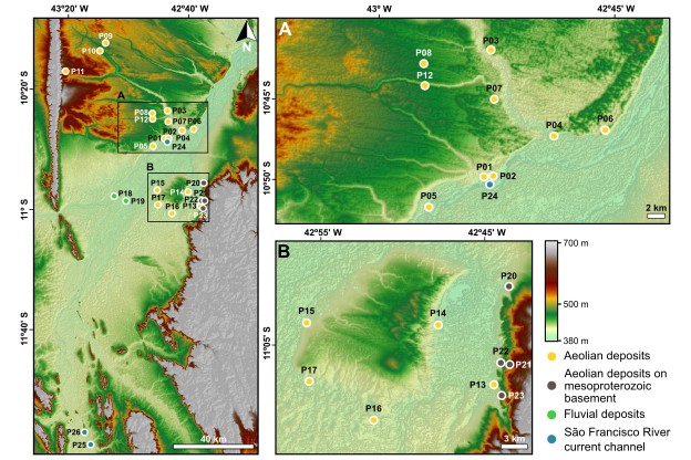
For this study, we collected samples from 26 different sites; granulometric analysis was performed on all sampled sites (comprising 102 samples), while heavy minerals analysis was performed on 23 sites (comprising 25 samples). The most sites were of aeolian deposits (17 sites), located on both margins of the São Francisco River, in order to cover the different geomorphological zones: 1) parabolic megadunes (MD); 2) compound parabolic dunes (CD); 3) aeolian plain (AP); 4) perched dunes (PD); 5) undifferentiated (UN), that group aeolian deposits which could not be associated with the adopted classification (sensu Mescolotti et al. 2023). In addition to different aeolian geomorphologies, samples with different ages were also chosen (previously dated by Mescolotti et al. 2023), to verify if there were changes in the sedimentary source over time
We also sampled two sites on the fluvial terraces (FD) and three on the active river channel (SFC) to verify the signature of these deposits. Mesoproterozoic basement sediment contribution was examined by contrasting analyzes of four samples of undifferentiated aeolian deposits occurring immediately above the rocks of the Chapada Diamantina Group (AB) against the other samples (Table I, Fig. 3).
Sampling location, depth, age and analyzes performed. MD = megadunes; CD = compound dunes; PD = perched dunes; AP = aeolian plain; UN = undifferentiated aeolian deposits; AB = aeolian deposits on mesoproterozoic basement; FD = older fluvial deposits; SFC = São Francisco River active channel; HM = heavy mineral analysis; G = granulometric analysis. (1) From Mescolotti et al. (2021, 2023).

Particle size analysis
Particle size analysis was performed by laser diffraction in the Mastersizer 2000, with Hydro 2000MU coupled. The samples were analyzed in a solution of 800 ml of deionized water and three drops of sodium hexametaphosphate (10%), to avoid agglutination of fine sediments.
We collected samples every 20 cm (base to top) from seven vertical sections (P01, 02, 07, 08, 09, 14 and 15), previously described by Mescolotti et al. (2023), totaling 83 samples. Our sampling criteria was aimed to verify if there are vertical variations in the particle size of the aeolian deposits. From the remaining 19 sites, single samples were collected and analyzed, resulting in 102 samples.
Heavy minerals analysis
Heavy minerals analysis was carried out in samples from 23 sites (Table 01), and in two particle sizes (very fine and fine sand), to verify influence of hydraulic selection (Garzanti & Andò 2019). Each sample was weighed, and the proportions of the very fine and fine sand fractions relative to the total sediment were determined, as well as the proportions of heavy minerals within these fractions. The heavy minerals were separated using heavy liquid (bromoform - CHBr3, ~2.9 g/cm³ density) and permanent mounts were assembled using Canada balsam mounting medium (refraction index of 1.54). We identify and quantify the minerals with aid of a petrographic microscope, through point-counting of 300 translucid grains from the total assemblage (Mange & Maurer 1992). The results were recalculated to 100% and mineral abundances were presented in percentages. Those lower than 1% were considered trace minerals.
The RZi index (rutile and zircon), derived from the formula 100 x rutile count / (total rutile plus zir con), was used to evidence possible changes in the sedimentary provenance, and the TZi index (tourmaline and zircon), derived from the formula 100 x tourmaline count / (total tourmaline plus zir con), was used as an indicator of hydraulic controls on deposition (Morton & Hallsworth 1994). These indexes were obtained from independent counting of 200 grains from each sample.
High-resolution Heavy Minerals Analysis (HRHMA), as proposed by Mange & Wright (2007), was performed for tourmaline and zircon, with independent counting of 100 grains. Tourmaline grains were subdivided in four categories based on morphology (habit and roundness) (T1 to T4) (Fig. 11a). Zircon grains were also subdivided in four categories based on the same criteria (Z1 to Z4) (Fig. 11b).
For statistical analysis, the workflow proposed by Verhaegen et al. (2018) was applied. First, the logarithmic transformation of the compositional data was performed, followed by classical multivariate statistical methods, such as cluster analysis and principal component analysis (PCA). For data visualization and interpretation, a logarithmic ratio graph was generated from the variables obtained in the PCA results.
RESULTS
Particle size analysis
In terms of grain size, aeolian deposits in the study area are predominantly constituted by medium sands, moderately sorted. The distribution pattern is mainly symmetric, skewed by a less frequent presence of fine sediments (clay and silt) tail (Figs. 4 and 5). On the west margin, deposits are mostly of medium sands, with occasional fine sand, moderately sorted. On the east margin, medium, poorly sorted sands dominate. In most vertical sections analyzed (with exception of the sites P01, P09 and P14), no significant vertical variations in grain size were observed (Fig. 6). On the east margin, there is a predominance of medium sand with no significant grain size variation. The aeolian deposits over the mesoproterozoic basement (AB) are mostly composed of poorly sorted, medium sands.

Box and dots plots of the main granulometric parameters analyzed. When sample size (N) is less than 5, individual values are inserted. N aeolian deposits on the west margin: MD = 2; CD = 3; PD = 2; EP = 2; UN = 5. N aeolian deposits on the east margin: MD = 1; CD = 1; UN = 3; EB= 4. N other deposits: FD = 2; SFC = 3.

Grain size distribution charts. MD = megadunes; CD = compound dunes; PD = perched dunes; AP = aeolian plain; UN = undifferentiated aeolian deposits; AB = aeolian deposits on mesoproterozoic basement; FD = older fluvial deposits; SFC = São Francisco River active channel.

In the active channel of the São Francisco River (SFC), moderately sorted, medium sands predominate, however, close to Ibotirama city (P25 and 26), the general grain size is coarser than the one from the adjacent western margin dune field (P24) (Figs. 4 and 5). Old fluvial deposits (FD) are composed of poorly sorted, medium sands, and fine, moderately sorted sands. Low-level terraces and old meander belt, at P01 and P14, (sensu Mescolotti et al. 2021) accumulated 8 to 33% of fine sediments (clay and silt), while aeolian deposits have less than 1% of fine fractions (Fig. 6).
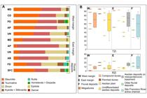
Heavy minerals identified in the study area, and TZi and RZi indices values. A) Proportion of heavy minerals. MD = megadunes; CD = compound dunes; PD = perched dunes; AP = aeolian plain; UN = undifferentiated aeolian deposits; AB = aeolian deposits on mesoproterozoic basement; FD = older fluvial deposits; SFC = São Francisco River active channel; B) Box and dots plots of frequencies of RZi and TZi indices. When sample size (N) is less than 5, individual values are inserted. N west margin: MD = 2; CD = 3; PD = 2; EP = 2; UN = 5. N east margin: MD = 1; CD = 1; UN = 3; EB: 4. N other deposits: FD = 2; SFC = 3.
Heavy minerals
The proportion of heavy minerals exhibits low variability in the aeolian deposits; however, the values increase in the São Francisco active channel near the Ibotirama city (Table 02). The non-micaceous, transparent heavy minerals identified were, in order of abundance: staurolite, tourmaline, zircon, kyanite, sillimanite, rutile, hornblende, epidote, diopside, and garnet. In the aeolian deposits of the west margin, the most abundant heavy mineral is staurolite (~42%), and greater mineralogical diversity (7 species) occurs in the compound (CD) and perched (PD) dunes (Fig. 8a). Significant amounts of hornblende, diopside, and epidote (>1%) are only observed in these dunes.

On the east margin, the most abundant heavy mineral is tourmaline (~50%), followed by zircon. Similarly, to the west margin, the amounts of hornblende, diopside and epidote are low, being hornblende and diopside only observed in megadune (MD) and diopside in the aeolian plain (AP). The aeolian deposits over the mesoproterozoic basement (AB) have the lowest mineralogical diversity among all the analyzed sites, with only tourmaline, zircon, staurolite, kyanite and rutile occurring with more than 1% of abundance.
Aeolian deposits of both margins are therefore similar; the main difference lies in the proportion of the three most abundant heavy minerals (staurolite, tourmaline and zircon). Meanwhile, staurolite is the main mineral in the São Francisco active channel (SFC). The fluvial sediments, old and active, have high mineralogical diversity (8 species), with the notable presence of garnet (Fig. 8a). In addition, several staurolite grains present dissolution features, and other minerals are corroded (such as hornblende and diopside).
The RZi and TZi indices values are very similar across the analyzed deposits (Fig. 8b). In the aeolian deposits on both margins, the RZi index presents similar average values, reaching the highest values in the older fluvial deposits and in the São Francisco active channel (RZi = 16 and 17, respectively). As for the TZi index, the aeolian deposits also present similar average values, and the older fluvial deposits have the lowest average (TZi = 48).
Three groups can be discerned through Cluster analysis (A, B and C; Fig. 8). Mainly the aeolian deposits on the mesoproterozoic basement and the dune field of the east margin form group A, comprising mainly samples of very fine-grained sand. The second group (B) is composed by fine-grained sand samples from the dune field in the west margin. Group C also includes samples from the aeolian deposits in the west margin, as well as from the older fluvial deposits and from the São Francisco active channel, and contains proportional amounts of very fine and fine-grained sand (Fig. 5). Groups B and C show more similarities between each other than with group A (east margin aeolian features).
Principal component analysis shows an opposite pattern for ultrastable heavy minerals (positive PC1) compared to other minerals (negative PC1), such as unstable HM and metamorphic minerals. Most of the deposits on the west margin and of the São Francisco River are concentrated in the negative PC1 and PC2 region (Fig. 9), and most of the deposits on the east margin, including the aeolian deposits on the mesoproterozoic basement, occur in the positive PC1 region.

Graph of PCA and weight of total mineralogy variables. Di = diopside; Ep = epidote; Gr = garnet; Hb = hornblende; Ky = kyanite; Rt = rutile; Sil = sillimanite; St = staurolite; Tur = tourmaline; Zr = zircon.
Based on PCA vectors (Fig. 9), abundance and frequency of staurolite, tourmaline, and zircon were selected to make log-ratio plots (Fig. 10). Three distinct groups can be observed: I) samples from the aeolian deposits of the east margin and from above the mesoproterozoic basement; II) samples from the west margin, the older fluvial deposits, and the São Francisco active channel; III) samples from the fluvial deposits (older and active channel).

Biplot of logarithmic heavy-mineral ratios. Staurolite, zircon, and tourmaline were selected based on PCA (Fig. 9).
Tourmaline and Zircon Varieties Analysis
Regarding tourmaline morphology, the moderately- to well-rounded anhedral variety (T1; Fig. 11a) is the most common, except in the aeolian deposits over the mesoproterozoic basement, where anhedral subangular to angular (T2) are dominant. Comparison between the aeolian deposits of the west and east margins shows that the T2 variety occurs more frequently on the east margin, and the more rounded T1 variety is ubiquitous on the west margin. Euhedral tourmalines (T4) were not observed in the parabolic megadune on the east margin (Fig. 11c).
The analysis of zircon varieties showed that the anhedral, moderately- to well-rounded grains are the most abundant (Z1; Fig. 11b), except in the compound dune of the east margin (P14) and in the aeolian deposits on mesoproterozoic basement, where anhedral, subangular to angular zircons predominate (Z2) (Fig. 11d).

High-resolution Heavy Minerals Analysis. A) Categories of tourmaline morphologies. T1 = anhedral moderately- to well-rounded; T2 = anhedral subangular to angular; T3 = subhedral; T4 = euhedral. B) Categories of zircon morphologies. Z1 = anhedral moderately- to well-rounded; Z2 = anhedral subangular to angular; Z3 = subhedral; Z4 = euhedral; C) Frequencies of tourmaline morphology. T1 = anhedral moderately- to well-rounded; T2 = anhedral subangular to angular; T3 = subhedral; T4 = euhedral; D) Frequencies of zircon morphology. Z1 = anhedral moderately- to well-rounded; Z2 = anhedral subangular to angular; Z3 = subhedral; Z4 = euhedral. MD = megadunes; CD = compound dunes; PD = perched dunes; AP = aeolian plain; UN = undifferentiated aeolian deposits; AB = aeolian deposits on mesoproterozoic basement; FD = older fluvial deposits; SFC = São Francisco River active channel.
DISCUSSION
Sedimentary sources of dunes and paleodunes
Contrasting provenance signals were expected for the aeolian samples from each margin due to: 1) prevailing E-W and SE-NW wind directions during Quaternary; 2) proximity between the east dune field and the mesoproterozoic basement, composed mainly of Chapada Diamantina Group rocks; and 3) the São Francisco River being considered, by Barreto & Suguio (1993), as the only source of sediments for the aeolian deposits on the west side margin.
Heavy mineral assemblage from the São Francisco River active channel, with its predominance of staurolite, tourmaline, and zircon, reflects the composition of source rocks from the drainage basin (Fig. 12), such as the crystalline terrains of the São Francisco Craton basement, the Bambuí Group, and the Cenozoic sedimentary cover (Bizzi et al. 2003). Of these terrains, the one with the greatest regional areal occurrence is the Paramirim Complex. Hydrothermal veins of tourmaline and quartz, and kyanite tabular crystals have been reported in the rocks of this Complex and in its surroundings (Loureiro et al. 2008). Medium-grade metamorphic rocks from the Santo Onofre/Oliveira dos Brejinhos Group (Jardim de Sá 1978) that occurs in the region of Oliveira dos Brejinhos city and to the south (along the Paramirim deformation corridor, sensu Alckmin et al. 1993), are expected to be the source of typical metamorphic minerals, such as staurolite, kyanite, and sillimanite. Unstable minerals (hornblende and diopside) are abundant on mafic rock intrusions in the Espinhaço Supergroup and its basement (Schobbenhaus 1996). Epidote, zircon, rutile, and tourmaline are some of the most common heavy minerals found in eluvial/colluvial gravels in the Gentio do Ouro area (Carvalho 1985).

The mineralogy of the fluvial terraces (older fluvial deposits) is similar to that of the active channel. Thus, fluvial terraces likely acted as temporary storage during aggradation phases (Mescolotti et al. 2021) and it is not possible to differentiate these sources through heavy mineral analysis. Aeolian activity phases are associated with phases of fluvial aggradation and high sediment supply (Mescolotti et al. 2023). Heavy mineral assemblage of the aeolian deposits on the west margin is very similar to those of the fluvial sediments and deposits, reinforcing the assumption that the São Francisco River is the main sediment source for these deposits. Younger aeolian deposits (Mescolotti et al. 2023), such as compound and perched dunes, have more varied mineralogy, with unstable minerals. The older aeolian deposits from the west margin, such as megadunes and undifferentiated aeolian deposits, show heavy mineral assemblages that lack unstable minerals, and staurolite and tourmaline occurs in the same proportions of the younger deposits, while zircon exhibit some variation that appears to be random. In addition, RZi index does not show considerable variations, which indicates that the sedimentary sources probably did not change over time (at least since 253.8±19.0 ka). Despite the relative homogeneity of heavy mineral assemblages of all analyzed deposits, with predominance of ultrastable (tourmaline and zircon) and stable (staurolite) mineral species (indication of high mineralogical maturity of these sediments), aeolian deposits over the mesoproterozoic basement have lower mineralogical diversity, and a contrasting proportion of most abundant minerals (Fig. 7). Additionally, on the west margin, the Serra do Estreito, trough the Icatu River (which initiates on the bottom of the mountain range), is also a probably source for the sediments. This geomorphological feature is composed by pure and micaceous quartzites, microscopically formed by fine to medium quartz grains and fine muscovite grains, and is included in the Santo Onofre Group, that endured metamorphism from the greenschist facies until the commencement of the amphibolite facies (Jardim de Sá 1978, Schobbenhaus 1996, Alcântara 2016). The Icatu River is a local tributary of the São Francisco River that cuts aeolian deposits of 7.6 ± 0.7 to 5.2 ± 1.4 ka (Mescolotti et al. 2021), being an important potential source for the sediments on this margin, since begins in the Serra do Estreito foothills (Figs. 1d and 2c), and acts transporting sediments from this ridge, from the terraces that occur on its margins, and from the dunes and paleodunes.
The adjacent rocks of the Paraguaçu and Chapada Diamantina groups show low-grade metamorphism, reaching a maximum of greenschist facies, with primary sedimentary structures still preserved (Schobbenhaus et al. 1984). The metasedimentary character of the source area is evidenced by the presence of staurolite, kyanite and sillimanite in the heavy mineral assemblages. Analysis of heavy minerals and varieties of tourmaline and zircons show that it is possible to establish a relationship between this dune field and the undifferentiated aeolian deposits that occur over rocks of the Paraguaçu and Chapada Diamantina groups. Furthermore, the remarkable presence of anhedral subangular to angular tourmaline and zircon varieties in this dune field suggests that the distance traveled by the sediments between the source area and the depositional setting was not long.
The box plots showing frequencies of morphology varieties of zircon highlight the separation between samples of undifferentiated aeolian deposits over mesoproterozoic basement and those of the São Francisco active channel. While in the former anhedral subangular to angular zircons (Z2) predominate, in the river channel most zircons are anhedral and moderately- to well-rounded (Z1). The grains transported as bed load in the river for long distances, underwent erosion and rounding due to abrasion, while anhedral subangular to angular grains preserved in the aeolian deposits onto mesoproterozoic basement can be understood as a result of the short distance between the source area and the deposition. Occurrence of anhedral moderately- to well-rounded varieties in the latter is significant (between 26 and 42% of occurrence frequency), and can be ascribed to the metasedimentary character of its source area (Chapada Diamantina Group).
Paleodunes on both river margins show more similarities than differences, regarding granulometry and heavy mineral data. The results of granulometric analysis demonstrated that the deposits are largely made of medium sand, and some of them present a fine sediments tail (predominantly silt, but also clay), resulting from post-depositional processes. The deposits are, in most cases, moderate to poorly sorted, with slightly positive skewness.
On the east margin, deposits are more poorly sorted than those on the west margin. This can be explained by the sediment source contributions of each margin: on the west margin, the São Francisco River is the main supplier, as ascertained by Barreto & Suguio (1993) and Barreto (1996), and therefore its sediments have undergone fluvial transport and consequently suffered rounding and sorting. On the east margin, the poorly sorted sediments can be understood due to the proximity between the dune field and the mesoproterozoic basement (one of the sources of these sediments). As the grains are transported over short distances, there is not enough time and space for sediment sorting. Deflationary deposits in the Itaparica lake are also contributors to the poor sorting of these sediments (Figs. 13 and 15). Morphology varieties of tourmaline and zircon, with the predominance of more anhedral subangular to angular varieties, also support this hypothesis.
Sedimentary routing system
The São Francisco River has been considered by Barreto & Suguio (1993) as the only sediment source for the aeolian deposits on the west margin. The river has an average discharge of 2.500 m³/s, and, in the period between 1986 and 1999, the average daily suspended sediments at the Morpará station (located south of the Xique Xique aeolian system) was estimated at 36.7 Ktons/day (Lima et al. 2001). In terms of bed load, about 90% are medium sand, but there is some lateral variability, with the presence of coarse sediments in the regions close to the margins (Cidreira 2014), and the values of bed load vary between 400 to 4.5 Ktons/day (PLANVASF 1986).
Considering that the area of the dune field on the west margin is approximately 7.700 km² (ca. 77 km wide and 100 km long) and its average thickness is 70 m (Diniz & Lima 2008), the estimated volume of sand contained in the aeolian system is ca. 539x109 m³. Thus, assuming that the São Francisco River is the only source of sediments, and taking into account only its bed load (and that it would be constant through time), construction of the western margin paleodune field would require 1.1 Ma. This is a very optimistic reconstruction, that considers that the entire river bed load would be made available to the aeolian system. Although the calculations are hugely approximate, this rules out the hypothesis that the sediments were transported directly from the river to the dune field, since this paleodune field on the east margin has a markedly shorter time span, with oldest recorded aeolian activity from at least the Middle Pleistocene (253.8 ± 19.0 ka, Mescolotti et al. 2023).
The fluvial terraces (high and low-level, Mescolotti et al. 2021) seem to have acted as source for the sediments on both margins (Fig. 13). These terraces acted as storage for fluvial sediments (long-term sinks, sensu Allen & Heller 2011) and, in conditions of drier climate and lower flow of the São Francisco River, can be an important sedimentary source. Analogous terraces were registered on the margins of the Icatu River (Mescolotti et al. 2021). Mescolotti et al. (2021, 2023) correlated periods of aeolian activity with phases of fluvial aggradation (Fig. 14); OSL ages from ~60-18 ka and ~16-5 ka of these aeolian deposits are synchronous with the low-level terrace deposits. The onset of megadunes deposition occurred during an incision event, with lower sediment availability from the river (Mescolotti et al. 2021), so the fluvial terraces possibly provided most of the sediments for the generation of these aeolian features. The development of compound dunes started later (~15 ka), during a high sediment supply phase which is partially contemporary with the younger meander belt. So, the main periods of aeolian activity would be related not only to the arid climate, but also to periods of fluvial aggradation and high sediment supply (Mescolotti et al. 2023). Therefore, the stabilization event (~5 ka) seems to be related to low sedimentary input during fluvial incision period (Mescolotti et al. 2023).

Schematic model of the sedimentary route system for the Xique Xique aeolian system (geomorphological map modified from Mescolotti et al. 2023).

Schematic model of geomorphological and sedimentary evolution of the Xique Xique aeolian system region during the late Quaternary (modified from Mescolotti et al. 2021).
The undifferentiated aeolian deposits on the east margin are younger (oldest recorded age of 55.6 ± 4.1 ka) than the west margin deposits (oldest age of 253.8 ± 19.0 ka) (Mescolotti et al. 2023). The oldest deposit from the west margin (P05) has low mineralogical diversity, with a predominance of ultrastable and stable minerals, while the other deposits have more diverse mineralogy, and moderately unstable and unstable species. On the east margin, ultrastable heavy minerals (tourmaline and zircon) are prevalent in the assemblage, with very small quantities of unstable minerals on younger deposits. The enrichment in ultrastable and stable minerals in P05 indicates a longer time under post-depositional processes.
Statistical analysis of heavy minerals and grain size data demonstrates that the aeolian deposits of both margins have more similarities than differences. One hypothesis is that the fluvial terraces and the rocks of the Chapada Diamantina and Paraguaçu groups acted as sedimentary sources. Another possible explanation is that the Itaparica Lake and its southern region are deflationary zones that would have supplied sediments to the west dune field, considering the regional wind pattern. Annual satellite images from 2016 to 2020 demonstrate that the lake goes through periods of flood and drought, and during dry periods, sediments are available for aeolian transport (Fig. 15). In addition, the similarities can also be attributed to the contribution of the fluvial terraces, which provided a large part of the sediments necessary for the construction of the aeolian system, through wind reworking.

Wet and dry periods of the Itaparica Lake. Satellite image: Google Earth Pro font, natural color, 2016, 2017, 2018, 2019 and 2020.
The differences between the aeolian deposits from each margin can be attributed to the presence of the mesoproterozoic basement (Paraguaçu and Chapada Diamantina groups) to the eastern of the dune field on east margin. Due to the mineralogical similarities between the aeolian deposits of this field and those on top of the mesoproterozoic basement, as well as the morphological varieties of tourmaline and zircon, we considered that the basement acted as an important sedimentary source for the dune field on this margin. The presence of staurolite grains with dissolution features and other corroded minerals (such as hornblende and diopside) indicates that the sediments underwent chemical weathering and diagenesis during their temporary storage on the terraces. However, the time elapsed between temporary storage on the terraces and wind transport was not long, since moderately unstable and unstable heavy minerals are present (diopside, sillimanite, kyanite and hornblende).
CONCLUSIONS
The Xique Xique aeolian system is a geomorphological feature that has been known since the last century, and since the early days, the significant volume of wind deposits in this important sedimentary field has drawn attention. Based on heavy minerals, granulometric and varieties analyses we had the means to make inferences about the sedimentary provenance and the sedimentary routing system in the Xique Xique aeolian system, as well to verify the influence of the São Francisco River in these dune fields. The use of heavy minerals as indicators of sedimentary provenance in the aeolian system proved to be an effective tool, since it shows that the dune fields sediments in both margins of the São Francisco River have more similarities than differences (despite the geographic barrier imposed by the river).
The results shows that the dunes fields are largely influenced by the river history, climate and the wind direction, once we considered that the fluvial terraces acted as the main source of sediments (being a long-term sink) and, depending on the climate conditions, provided large amounts of sediment to the aeolian system.
Along the west margin, compositional and textural characteristics remain relatively constant as the distance from the active channel increased. This apparent uniformity, along with the grain-size data (no consistent vertical or spatial trends), suggests that the fluvial input is reworked and homogenized by aeolian processes once introduced into the dune field. Similarities between the samples from the active river channel and those from the dune field on the west margin indicate that, on this margin, the São Francisco River, as well as the Icatu River, may have acted directly as a sedimentary source. Although the hypothesis that the sediments were solely supplied by the river to the wind system has been ruled out, its subordinate sediment contribution is still plausible. The almost homogeneous presence of moderately- to well-rounded tourmaline and zircon grains in these aeolian deposits supports this hypothesis, as the rounding reflects long-distance transport prior deposition.
On the east margin, the mineralogical assemblages, morphological varieties analysis and the presence of poorly sorted sediments indicate that, besides rivers terraces, the mesoproterozoic basement acted as an important sediment source for this margin. This interpretation is corroborated by the physical proximity between this dune field and the basement, and the wind direction.
This, in addition to this difference in sources between the dunes on the east and west margins, with our analyses on Xique Xique aeolian deposits of different ages, we interpret that the sedimentary sources probably did not change significantly during the Late Quaternary.
Acknowledgements
The financial support was provided by the Conselho Nacional de Desenvolvimento Científico e Tecnológico (CNPq, grant # 406582/2023-8). MLA is a research fellow of the CNPq (grant #310955/2021-1). CCFG is a research fellow of the CNPq (grant #3304620/2022-0).
References
- AB’SABER A. 2006. O paleodeserto de Xique-Xique. Est Av 20: 301-308.
- ALCÂNTARA DCBG. 2016. Estratigrafia, tectônica e geocronologia U-Pb (LA-ICP-MS) em zircão detrítico dos Grupos Rio Preto e Santo Onofre, Faixa Rio Preto e norte do Corredor Paramirim – Bahia e Piauí/Brasil. Universidade Federal de Minas Gerais, Instituto de Geociências.
-
AL FARRAJ A & HARVEY AM. 2004. Late Quaternary interactions between aeolian and fluvial processes: a case study in the northern UAE. J Arid Environ 56 (2): 235-248. https://doi.org/10.1016/S0140-1963(03)00054-5.
» https://doi.org/10.1016/S0140-1963(03)00054-5 - ALCKMIN FF, NEVES BBB & ALVES JAC. 1993. Arcabouço tectônico do Cráton São Francisco: uma revisão. In: Misi A & Dominguez JML (Eds), O Cráton São Francisco. SBG, Salvador, p. 45-62.
-
ALLEN PA. 2017. Sediment routing system. The fate of sediments from source to sink. Cambridge University Press, Cambridge, 407 p. https://doi.org/10.1017/9781316135754
» https://doi.org/10.1017/9781316135754 - ALLEN PA & HELLER PL. 2011. Dispersal and preservation of tectonically generated alluvial gravels in sedimentary basins. In: Busby C & Azor A (Eds), Tectonics of sedimentary basins: recent advances. Wiley-Blackwell, Oxford, p. 11-130. https://doi.org/10.1002/9781444347166.ch6.
- ALMEIDA FF. 1977. O Cráton São Francisco. Rev Bras Geociênc 7(4): 348-367.
-
ALVARES CA, STAPE JL, SENTELHAS PC, GONÇALVES JLM & SPAROVEK G. 2013. Köppen’s climate classification map for Brazil. Meteorol Z 22 (6): 711-728. https://doi.org/https://doi.org/10.1127/0941-2948/2013/0507.
» https://doi.org/10.1127/0941-2948/2013/0507 - BARRETO AMF. 1993. Estudo morfológico e sedimentológicos da porção norte do mar de areia fóssil do médio Rio São Francisco, Bahia. Universidade de São Paulo, Instituto de Geociências.
- BARRETO AMF & SUGUIO K. 1993. Considerações sobre a idade e a paleogeografia das paleodunas do médio Rio São Francisco, Bahia. In: Congresso da Associação Brasileira de Estudos Quaternários 4, São Paulo. Boletim de resumos expandidos, p. 11.
- BARRETO AMF, SUGUIO K, OLIVEIRA PE & TATUMI SH. 2002. Campos de Dunas Inativas do Médio Rio São Francisco, BA: Marcante registro de ambiente desértico do Quaternário brasileiro. Sítios Geológicos e Paleontológicos do Brasil 56: 223-231.
- BARTORELLI A, ASSINE ML, PIRES NETO A & AB’SABER A. 2010. Dunas do Jalapão: uma paisagem insólita no interior do Brasil. In: Modenesi-Gauttieri MC et al. (Eds), A obra de Aziz Nacib Ab’Saber. Beca-BALL edições, São Paulo, p. 569-582.
- BIZZI LA, SCHOBBENHAUS C, VIDOTTI RM & GONÇALVES JH. 2003. Geologia, tectônica e recursos minerais do Brasil. CPRM - Serviço Geológico do Brasil, Brasília, 692 p.
-
CARACCIOLO L. 2020. Sediment generation and sediment routing systems from a quantitative provenance analysis perspective: review, application and future development. Earth-Sci Rev 209: 103226. https://doi.org/10.1016/j.earscirev.2020.103226.
» https://doi.org/10.1016/j.earscirev.2020.103226 - CARVALHO LM. 1985. Projeto Gentio do Ouro: relatório final de pesquisa, 201 p.
-
CARVALHO AM, ELLIS JT, LAMOTHE M & PARENTE L. 2016. Using wind direction and shoreline morphology to model sand dune mobilization. J Coast Res 32(5): 1005-1015. https://doi.org/10.2112/JCOASTRES-D-14-00258.1
» https://doi.org/10.2112/JCOASTRES-D-14-00258.1 - CIDREIRA MAS. 2014. Efeito do fundo móvel em medições acústicas no trecho sub médio do rio São Francisco. Universidade Federal da Bahia, Escola Politécnica.
- DINIZ JAO & LIMA JB. 2008. O aquífero de dunas na região do Médio São Francisco – BA. Águas Subterrâneas.
-
EAST AE, CLIFT PD, CARTER A, ALIZAI A & VANLANINGHAM S. 2015. Fluvial-eolian interactions in sediment routing and sedimentary signal buffering: an example from the Indus Basin and Thar Desert. J Sediment Res 85(6): 715-728. https://doi.org/10.2110/jsr.2015.42.
» https://doi.org/10.2110/jsr.2015.42 -
GARZANTI E & ANDÒ S. 2019. Heavy minerals for junior woodchucks. Minerals 9: 1-25. https://doi.org/10.3390/min9030148.
» https://doi.org/10.3390/min9030148 -
GARZANTI E, PASTORE G, STONE A, VAINER S, VERMEESCH P & RESENTINI A. 2022. Provenance of Kalahari Sand: paleoweathering and recycling in a linked fluvial-aeolian system. Earth-Sci Rev 224: 103867. https://doi.org/10.1016/j.earscirev.2021.103867.
» https://doi.org/10.1016/j.earscirev.2021.103867 - GIANNINI PCF, ASSINE ML, BARBOSA LM, BARRETO AMF, CARVALHO AM, CLAUDINO-SALES V, MAIA LP, MARTINHO CT, PEULVAST JP & SAWAKUCHI AO. 2005. Dunas e paleodunas eólicas costeiras e continentais. In: Souza CRG et al. (Eds), Quaternário do Brasil. Holos, Ribeirão Preto, p. 235-257.
- GUIMARÃES JT. 2005. Projeto Ibitiara-Rio de Contas: estado da Bahia, 193 p.
-
HU F & YANG X. 2016. Geochemical and geomorphological evidence for the provenance of aeolian deposits in the Badain Jaran Desert, northwestern China. Quat Sci Rev 131: 179-192. https://doi.org/10.1016/j.quascirev.2015.10.039.
» https://doi.org/10.1016/j.quascirev.2015.10.039 - INDA HAV & BARBOSA JF. 1978. Texto explicativo para o Mapa Geológico do Estado da Bahia, escala 1:1.000.000, 137 p.
- JARDIM DE SÁ EF, BARTELS RL, BRITO NEVES BB & MCREATH I. 1976. Geocronologia e modelo tectonomagmático da Chapada Diamantina e Espinhaço Setentrional. In: Congresso Brasileiro de Geologia 29, Ouro Preto. Anais, p. 205-227.
- JARDIM DE SÁ EF. 1978. Geologia da Chapada Diamantina e Faixa Santo Onofre, Bahia, e geoquímica do vulcanismo ácido associado. Universidade Federal da Bahia, Instituto de Geociências.
- KOUSKY VE. 1979. Frontal influences on northeast Brazil. Mon Weather Rev 107(9): 1140-1153.
- KOUSKY VE & CHU PS. 1978. Fluctuations in annual rainfall for northeast Brazil. J Meteorol Soc Jpn 56(5): 457-465.
- KOUSKY VE & CAVALCANTI IFA. 1988. Pentad outgoing longwave radiation climatology for the South America sector. Rev Bras Meteorol 3: 217-231.
- LANGFORD RP. 1989. Fluvial-aeolian interactions: Part I, modern systems. Sedimentology 36 (6): 1023-1035.
- LIMA JEFW, SANTOS PMC, CHAVES AGM & SCILEWSKI LR. 2001. Diagnóstico do fluxo de sedimentos em suspensão na Bacia do rio São Francisco, 99 p.
- LOUREIRO HSC ET AL. 2008. Projeto Barra - Oliveira dos Brejinhos, Estado da Bahia, 183 p.
- LOUREIRO HSC, BAHIENSE IC, DAS NEVES JP, GUIMARÃES JT, TEIXEIRA LR, DOS SANTOS RA & DE MELO RC. 2009. Geologia e recursos minerais da parte norte do Corredor de Deformação Paramirim (Projeto Barra - Oliveira dos Brejinhos), 126 p.
- MANGE MA & MAURER HFW. 1992. Heavy minerals in colour. Chapman and Hall, London, 147 p.
- MANGE MA & WRIGHT DT. 2007. High-resolution heavy mineral analysis (HRHMA): A brief summary. In: Mange M & Wright DT (Eds), Heavy minerals in use. Developments in Sedimentology 58. Elsevier, Amsterdam, p. 433-436. https://doi.org/10.1016/S0070-4571(07)58016-7.
-
MEHL A, TRIPALDI A & ZÁRATE M. 2018. Late Quaternary aeolian and fluvial-aeolian deposits from southwestern Pampas of Argentina, southern South America. Palaeogeogr Palaeoclimatol Paleoecol 511: 280-297. https://doi.org/10.1016/j.palaeo.2018.08.014.
» https://doi.org/10.1016/j.palaeo.2018.08.014 - MESCOLOTTI PC. 2021. Planície fluvial e campo de dunas eólicas do médio rio São Francisco: cronologia de depósitos e sucessão de eventos geológicos durante o Quaternário no Brasil. Universidade Estadual Paulista, Instituto de Geociências e Ciências Exatas.
-
MESCOLOTTI PC, PUPIM FN, LADEIRA FSB, SAWAKUCHI AO, CATHARINA AS & ASSINE ML. 2021. Fluvial aggradation and incision in the Brazilian tropical semi-arid: climate-controlled landscape evolution of the São Francisco River. Quat Sci Rev 263: 106977. https://doi.org/10.1016/j.quascirev.2021.106977.
» https://doi.org/10.1016/j.quascirev.2021.106977 -
MESCOLOTTI PC, GIANNINI PCF, PUPIM FN, SAWAKUCHI AO, LADEIRA FSB & ASSINE ML. 2023. The largest Quaternary inland eolian system in Brazil: eolian landforms and activation/stabilization phases of the Xique-Xique dune field. Geomorphology 420: 108516. https://doi.org/10.1016/j.geomorph.2022.108516.
» https://doi.org/10.1016/j.geomorph.2022.108516 - MORTON AC & HALLSWORTH CR. 1994. Identifying provenance-specific features of detrital heavy minerals assemblages in sandstones. Sediment Geol 90: 241-256.
-
NOTTEBAUM V, LEHMKUHL F, STAUCH G, LU H & YI S. 2015. Late Quaternary aeolian sand deposition sustained by fluvial reworking and sediment supply in the Hexi Corridor - an example from northern Chinese drylands. Geomorphology 250: 113-127. https://doi.org/10.1016/j.geomorph.2015.08.014.
» https://doi.org/10.1016/j.geomorph.2015.08.014 -
OLIVEIRA PE, BARRETO AMF & SUGUIO K. 1999. Late Pleistocene/Holocene climatic and vegetacional history of the Brazilian caatinga: the fossil dunes of the middle São Francisco River. Palaeogeogr Palaeoclimatol Palaeoecol 152: 319-337. https://doi.org/10.1016/S0031-0182(99)00061-9.
» https://doi.org/10.1016/S0031-0182(99)00061-9 - PLANVASF – PLANO DIRETOR PARA O DESENVOLVIMENTO INTEGRADO DO VALE DO SÃO FRANCISCO. 1986. Diagnóstico sedimentológico na Bacia do São Francisco, 92 p.
- PEREIRA SB, PRUSKI FF, SILVA DD & RAMOS MM. 2007. Estudo do comportamento hidrológico do Rio São Francisco e seus principais afluentes. Rev Bras Eng Agríc Ambient 11(6): 615-622.
- RODRIGUES MT. 1996. Lizards, snakes and amphisbaenians from the quaternary sand dunes of the middle Rio São Francisco, Bahia, Brazil. J Herpetol 30(4): 513-523.
-
SANTOS AÁB ET AL. 2013. Atlas eólico da Bahia. Camargo Schubert, Salvador, 96 p. Available at: https://www.ba.gov.br/seplan/sites/site-seplan/files/migracao_2024/arquivos/wp-content/uploads/atlaseolicobahia2013.pdf
» https://www.ba.gov.br/seplan/sites/site-seplan/files/migracao_2024/arquivos/wp-content/uploads/atlaseolicobahia2013.pdf -
SANTOS LA & LATRUBESSE EM. 2021. Aeolian mobility in the Middle São Francisco Dune Field, Northeast Brazil, as a response to caatinga’s droughts and land-use changes. Geomorphology 393: 107940. https://doi.org/10.1016/j.geomorph.2021.107940.
» https://doi.org/10.1016/j.geomorph.2021.107940 - SCHOBBENHAUS CF. 1972. Relatório geral sobre a geologia da região setentrional da Serra do Espinhaço - Bahia Central, 91 p.
- SCHOBBENHAUS CF. 1993. O Proterozoico Médio no Brasil com ênfase à região centro-leste: uma revisão. Albert-Ludwigs- Universitàt Freiburg im Breisgau, Geowissenschaftliche Fakultät.
- SCHOBBENHAUS CF. 1996. As tafrogêneses superpostas Espinhaço e Santo Onofre, Estado da Bahia: revisão e novas propostas. Rev Bras Geociênc 26(4): 265-276.
- SCHOBBENHAUS CF, ALMEIDA CAMPOS D, DERZE GR & ASMUS NE. 1984. Geologia do Brasil. Texto explicativo do mapa geológico do Brasil e da área oceânica adjacente incluindo depósitos minerais, escala 1:2.500.000, 501 p.
- SOUZA JD ET AL. 2003. Mapa geológico do Estado da Bahia – Escala 1:1.000.000.
-
TRIPALDI A & ZÁRATE MA. 2016. A review of Late Quaternary inland dune systems of South America east of the Andes. Quat Int 410: 96-110. https://doi.org/10.1016/j.quaint.2014.06.069.
» https://doi.org/10.1016/j.quaint.2014.06.069 - UHLEIN A & PEDREIRA AJ. 1989. Considerações sobre a geologia estrutural, tectônica e fácies sedimentares do Espinhaço setentrional e Chapada Diamantina (BA). In: Simpósio de Geologia de Minas Gerais 5, Belo Horizonte, Anais, p. 180-183.
-
VERHAEGEN J, WELTJE GJ & MUNSTERMAN D. 2018. Workflow for analysis of compositional data in sedimentary petrology: provenance changes in sedimentary basins from spatio-temporal variation in heavy-mineral assemblages. Geol Mag 156(7): 1111-1130. https://doi.org/10.1017/S0016756818000584.
» https://doi.org/10.1017/S0016756818000584 -
WANG X, AULER AS, EDWARDS RL, CHENG H, ITO E & SOLHEID M. 2006. Interhemispheric anti-phasing of rainfall during the last glacial period. Quat Sci Rev 25: 3391-3403. https://doi.org/10.1016/j.quascirev.2006.02.009.
» https://doi.org/10.1016/j.quascirev.2006.02.009 -
WANG Z, WU Y, TAN L, FU T, WEN Y & LI D. 2019. Provenance studies of aeolian sand in Mu Us Desert based on heavy-minerals analysis. Aeolian Res 40: 15-22. https://doi.org/10.1016/j.aeolia.2019.05.003.
» https://doi.org/10.1016/j.aeolia.2019.05.003 - WILLIAMS HE. 1925. Notas geológicas e econômicas sobre o Vale do rio São Francisco. Boletim do Serviço Geológico e Mineralógico 12, 56 p.
-
ZHANG C, LI Z, CHEN Q, DONG S, YU X & YU Q. 2020. Provenance of eolian sands in the Ulan Buh Desert, northwestern China, revealed by heavy minerals assemblages. Catena 193: 104624. https://doi.org/10.1016/j.catena.2020.104624.
» https://doi.org/10.1016/j.catena.2020.104624
Edited by
-
Handling editor
Claudio Gaucher
The data supporting the findings of this study are available from the corresponding author upon reasonable request.