 A literature review about the deployment of accelerometers as non-seismic soil landslide tilting sensors
Abstract
Monitoring is an element of landslide early warning systems. Fukuzono’s method, based on displacement and velocity monitoring, is one of the most popular methods for slope time of failure (TOF) prediction. This critical literature review aimed to systematically analyze the state-of-the-art accelerometers used for slope monitoring and TOF prediction. Two peer-review online article platforms were used to build a database of 50 articles. Time history analysis showed that from 2014 onwards the interest in accelerometers has increased and using them as tilt sensors has become a well-accepted approach for geotechnical monitoring. However, special attention must be paid to calibration and noise reducing of low-cost sensors. Also, the installation setup may influence measurements. Alert thresholds and TOF prediction methods based on tilting rates for sensors buried at shallow depths have been proposed and few real validated cases are reported. These predictions attempt to find a simple relation between TOF and slope tilting rate, similar as Fukuzono’s method. Relations between tilting rate and surface displacement is an aspect that remains unclear. In order to clarify those aspects, more real slope cases should be reported. A more established use of accelerometers is as a chain of sensors buried in a borehole, similar to a permanent inclinometer. In these cases, accelerometer data are interpreted as displacement, in a more traditional way.
Keywords:
Geotechnical monitoring; Landslide early warning system; Time-of-failure prediction; Tilt angle
1. Introduction
Landslide forecasting is one of the key elements of Landslides Early Warning Systems (LEWS), which, in turn, are powerful tools for disaster risk reduction (United Nations Office for Disaster Risk Reduction, 2023). According to Intrieri et al. (2019), landslide forecasting comprises the prediction of the slope failure in spatial or temporal terms. The temporal prediction aims at determining the time-of-failure (TOF) and can be performed in global/regional or slope scales, depending on the monitored parameters. LEWS based on rainfall monitoring, as presented by Stähli et al. (2015), Piciullo et al. (2018), Pecoraro et al. (2019) and Guzzetti et al. (2020), work well to evaluate the likelihood of potential landslide in large areas (global/regional scales) but they are not effective to predict failure of an individual slope (Xie et al., 2020b). Slope-scale predictions are based on geotechnical monitoring related to displacement and its derivatives: velocity and acceleration (Intrieri et al., 2019).
One of the most used TOF prediction methods is the inverse velocity method, developed by Fukuzono (1985), which is a simple graphical approach to estimate TOF. It is based on the variation of the inverse velocity (1/v) along time. Extensometers, inclinometers, global positioning system (GPS) or robotic total station and interferometric techniques, such as ground-based interferometric synthetic aperture radar (GB-InSar) and light detection and ranging (LiDar), have been successfully used for displacement monitoring and landslide TOF forecasting with the inverse of velocity method (Federico et al., 2019; Loew et al., 2016; Ju et al., 2020; Zhang et al., 2020a).
However, the price of an entire monitoring system with most of those techniques/instruments is high and can be unacceptable for wide-scale application. Additionally, instruments such as extensometers require long cable connections, which constitute an inconvenient for installation and maintenance, increasing the cost even more (Uchimura et al., 2015; Qiao et al., 2020). A field of expertise where slope monitoring and landslide forecasting is needed is civil protection. However, available budgets in this sector are usually smaller than in the mining industry. Therefore, when it comes to risk-management strategies for civil protection, monitoring systems may represent an unaffordable cost and developing low-cost monitoring solutions is urgent.
The advances in Internet of Things (IoT) and wireless sensor network, data transmission and real-time monitoring enhanced cost-effective solutions for landslide monitoring, with reliable results (Ooi et al., 2014; Xie et al., 2019; Abraham et al., 2020a; Wang et al., 2022a). Moreover, the development of microelectronic technique made it possible to manufacture new low-cost sensors using micro electromechanical systems (MEMS) technology. MEMS sensors have the additional advantages of being smaller and lighter, as compared to traditional geotechnical monitoring systems. In this sense, using MEMS accelerometers stands out as a powerful solution for low-cost LEWS. According to Uchimura et al. (2010, 2015) and Sheikh et al. (2021) installation and maintenance of those sensors are easier than extensometers, for example, which results in lower costs. Additionally, the use of low-cost sensor networks allows installation of more sensors for effective slope monitoring (Abraham et al., 2020b).
Araújo et al. (2023) pointed out that originally digital instruments or the digitalization of traditional instruments have been the main tools for improvement of slope monitoring methods in recent years. MEMS Accelerometers show great potential to be used in LEWS. However, there is no recent work in the literature that systematically explains the application of accelerometers for slope monitoring as well as the advantages and limitations of the technique. This paper aims to fill this gap.
Accelerometers have been used for many purposes over the last 20 years: for structural health monitoring (Fukao et al., 2016; Xiao et al., 2016; Chen et al., 2021), for seismicity monitoring (Coccia et al., 2010; Wasowski et al., 2011; Tu et al., 2013; Del Gaudio et al., 2014, 2019) and for geotechnical monitoring, such as rockslides, rock falls and debris flows monitoring (Enet et al., 2003; Xu et al., 2011; Harding et al., 2014; Hu et al., 2018; Feng & Zhuang, 2021). In this paper we focused on the use of accelerometers for non-seismic soil landslide monitoring. In this type of use, measured acceleration is interpreted as tilt or inclination and these sensors are sometimes called “tilt sensors” or “tiltmeters”.
We present a critical literature review aiming at assessing the state of art of using accelerometers to detect soil landslide impending failure signals in non-seismic situations. The literature reviewed is limited to slides in soil, which involve clay and silt rotational and planar slides, gravel, sand and debris slides and clay and silt compound slides, as defined by Hungr et al. (2014). The term “landslide” used in this paper refers to these types of movement. The focus was placed on answering the following research questions: how have accelerometers been recently deployed in the laboratory and in field for slope monitoring, how has the data acquired by these sensors been interpreted in terms of slope stability and where are these new techniques being used?
2. Construction of the literature database
Articles were searched in two peer-reviewed online article platforms to build the literature database: Web of Science (Clarivate Analytics) and Scopus. Seven keywords were chosen and divided in three categories to perform the search: sensor type (“Accelerometer”, “Tilt sensor”, “Tiltmeter”), object of study (“Landslide”, “Slope”) and final purpose (“Monitoring”, “Early warning”). No time period constraints were used in the search.
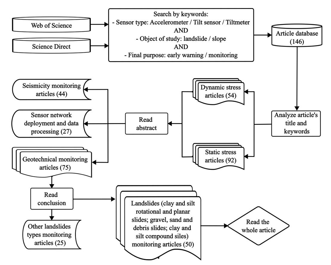
All possible combinations of one word of each category using Boolean criterion “AND” were applied to “title”, “abstract” and “keywords” of the publications in the search engines of the platforms and a preliminary database of 142 complete articles was obtained. The analytic procedure shown in Figure 1 was followed to filter the article database.

Flowchart of the methodology followed to build the database. Numbers in bracket correspond to the quantity of articles in each group.
The first step was to analyze the article’s title and keywords in order to make a preliminary division of our database to define the stress condition in which sensors were used. Dynamic stress articles group gathers articles in which sensor devices were used to monitor high and sudden frequency accelerations, as in high seismicity environments, whereas static stress articles assemble articles in which those sensors were used in low frequency and long-term vibrations context.
By reading all article´s abstracts it was possible to classify them in three groups:
-
Seismicity monitoring articles: in this group, sensors were used to monitor seismicity, in a similar way to seismometers. These 44 articles are typically related to landslides triggered by earthquakes. Sensors were not used to monitor soil movement but seismic activity or buildings structural integrity;
-
Sensor network deployment and data processing: refers to the 27 articles that are focused on network architecture and processing procedure and mathematical procedures for data analysis;
-
Geotechnical monitoring articles: this group gathers 75 articles which describe situations in which sensors are used as slope instrumentation to monitor soil kinematics.
The conclusions of all 75 geotechnical monitoring articles were read in order to analyze how accelerometers are being used for geotechnical monitoring purposes. After this step the 25 articles that described other landslide types monitoring cases, such as debris flows, earth flows, rock falls or submarine landslides, were excluded. The remaining 50 articles were classified as landslide monitoring articles and are the object of this paper. All cases in which sensors were used to monitor up to 1m soil depth were considered surface monitoring in this literature review. This includes experimental and real working conditions.
3. Literature analysis
3.1 Temporal and geographical analysis
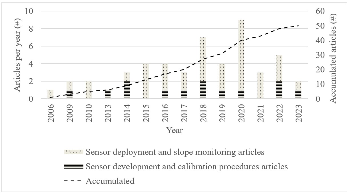
Details of the 50 articles analyzed in detail in this paper are presented in Otero et al. (2024). Of the 50 articles, 14 were published at conferences and 36 were published in peer-reviewed journals. They spread in a 17-year period: from 2006 to 2023, as presented in Figure 2.

Temporal distribution of the articles in the final database. Vertical bars show number of articles published each year. Dashed line shows accumulated articles during time series.
Regarding the quantity of articles published per year, between 2006 and 2013 the literature production concerning accelerometers for landslide monitoring remained under two articles per year. In fact, in 2007, 2008, 2011 and 2012 no articles regarding this issue were published. From 2014 to 2022, the rate increased to more than three articles per year (second period). 2018 and 2020 are the years with the highest numbers of publications (7 and 9, respectively).
Between 2006 and 2020, around 30% of the articles published were related to sensor development whereas 70% to sensor deployment and landslide monitoring. After 2020, 20% of the articles were related to sensor development and 80% to sensor deployment and landslide monitoring.
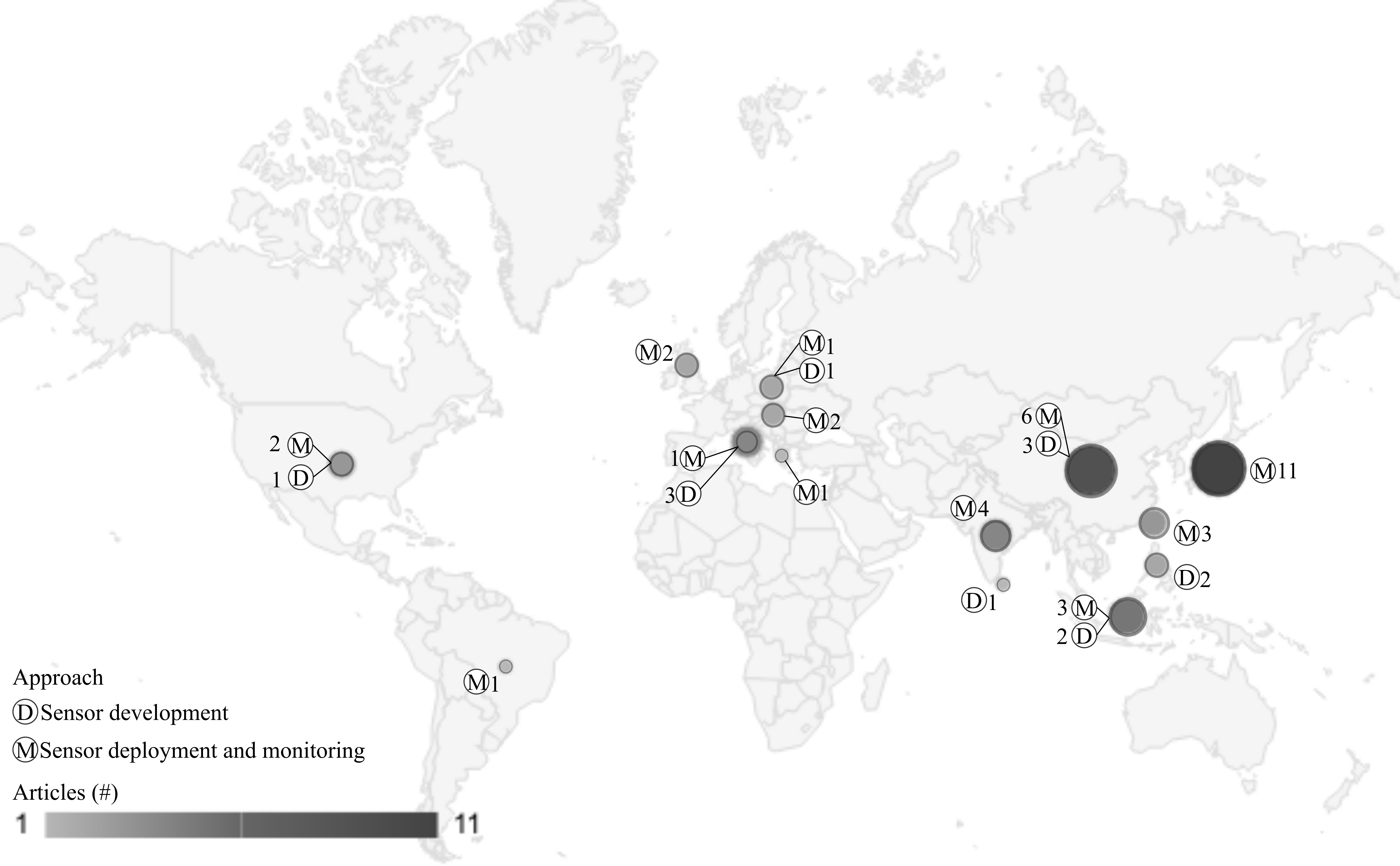
Figure 3 shows the geographical distribution for each approach, based on the first author’s affiliation. The research was done in four continents and 14 countries. Most of the articles (35) come from Asia followed by Europe (12), North America (3) and South America (1). Our research did not come up with articles from Africa and Oceania.
Geographical distribution of 47 articles of database. Capital letter refers to the main article approach and numbers beside them, to articles quantity regarding each approach. (D) prototype development and calibration procedures and (M) sensor deployment and landslide monitoring.
Considering the 14 countries where research was made, Japan has the largest number of articles (11) followed by China (9), Indonesia (5), India (4) and Taiwan (3). Those five countries make up almost 70% of the database (32 articles). This denotes that there is a stronger technical interest in Asian countries in using accelerometers for landslide monitoring than in Europe and in America.
According to their main objective regarding landslide monitoring, these 50 articles were divided in two categories: sensor deployment and slope monitoring and prototype development and calibration procedures. Both categories are discussed following.
3.2 Sensor deployment and slope monitoring
This category gathers 37 articles. They were thoroughly and completely analyzed in terms of working scale, installation setup, data acquisition and transmission, associated sensors and time of failure prediction or alert thresholds definition.
3.2.1 Working condition and scale
Articles were divided in terms of working conditions: real or experimental. In case of experimental conditions, two situations were identified: reduced scale experiments in flumes and full scales experiments. Table 1 presents details of working conditions and scale.
Summary of working conditions and scale, installation setup, acquisition frequency, measured parameter and associated sensors in each reference.
In experimental conditions, Ooi et al. (2014), Habil et al. (2016), Atmajati et al. (2017), Giri et al. (2018), Krokidis et al. (2018), Xie et al. (2019), Chen & Zhang (2021), Giri et al. (2022) and Otero et al. (2022) worked with laboratory flumes with dimensions ranging from 0.60 × 0.20 × 0.10 m to 2.00 × 1.49 × 0.50 m (length, width and height/depth, respectively). Uchimura et al. (2010), Feng et al. (2020a), Xie et al. (2020a, b), and Qiao et al. (2020) worked with real scale slope models in laboratory or in the field. In experimental conditions landslides were triggered by simulating natural conditions, such as rainfall infiltration or water table elevation.
In real working conditions, natural or built slopes were monitored under natural weather conditions, like in Chelli et al. (2006), Újvári et al. (2009), García et al. (2010), Wang et al. (2015, 2022a, b), Mentes (2015), Uhlemann et al. (2016), Jeng & Sue (2016), Dikshit et al. (2018), Artha & Julian (2018), Bednarczyk (2018), Dikshit & Satyam (2019a, b), Abraham et al. (2020a, b), Sheikh et al. (2020, 2021) and Putra et al. (2021),
In papers such as Uchimura et al. (2015), Towhata et al. (2015), Wang et al. (2017) and Xie et al. (2020a, b) the authors worked firstly in experimental conditions and then they validated their results in natural slopes that showed signs of impending failure.
3.2.2 Installation setup
Accelerometers were used to monitor surface or subsurface movements. Surface monitoring was more common than subsurface monitoring (29 articles against 5 articles of available data), as presented in Table 1. Some research groups attach the sensor to rods or install them into tubes, while other groups placed directly over the surface or embedded the sensor directly in the soil at shallow depths (less than 0.3 m), as presented in Table 2.
In reduced models, accelerometers were simply leaned over the surface soil, as in Giri et al. (2018, 2022), Feng et al. (2020a) and Chen et al. (2021), or embedded into the soil up to 30cm depth. Feng et al. (2020b), Xie et al. (2020a, b) and Otero et al. (2022) embedded sensors directly into the soil at shallow depth (from 3 cm to 20 cm). Habil et al. (2016) and Atmajati et al. (2017) embedded sensors at 20 cm and 30 cm respectively using Polyvinyl Chloride (PVC) pipes. Uchimura et al. (2010) and Qiao et al. (2020) attached sensors at the top of up to 30cm length rods.
In real scale models and in natural slopes the most common way to deploy the sensors is using steel rods. Some examples of this type of deployment can be found in Uchimura et al. (2015), Wang et al. (2017, 2022b), Dikshit & Satyam (2019b) and Xie et al. (2020a, b). Measuring devices are attached at the top of the rod that is inserted into the soil at 50 cm to 150 cm depth. Hence, if the soil experiences some movement, the rods move together, and this is measured by the devices installed at the top of the rod.
In the cases of subsurface monitoring, sensors are deployed in boreholes in real slope conditions. Újvári et al. (2009), García et al. (2010) and Mentes (2015) installed sensors at 3m depth with PVC pipes filled with granular soil, in order for the sensor to be strongly coupled to the ground.
Uhlemann et al. (2016) and Bednarczyk (2018) also deployed sensors in subsurface conditions, similarly to inclinometers. Uhlemann et al. (2016) deployed a commercial solution, developed by Abdoun et al. (2006, 2007), called “Shape acceleration array (SAA)” at 2.5 m depth and Bednarczyk (2018) used strings of rigid segments attached to each other, up to 16 m depths. Each segment contains one measuring device and the distance between them is 50 cm. Strings and SAA were installed inside PVC flexible pipes.
Segalini et al. (2014, 2015, 2019) deployed a system called Modular Underground Monitoring System (MUMS) that consists in an acceleration sensor chain up to 111 m. These papers were not retrieved in the literature search, because this group does not use the terms “Accelerometer”, “Tilt sensor” and “Tiltmeter” in their articles, but the MUMS are clearly an array of accelerometers deployed in subsurface conditions, similarly to inclinometers. For this reason, the papers produced by this group are discussed in this paper.
3.2.3 Data acquisition and transmission
Data acquisition rate was available in 23 articles (Table 1). The most common acquisition frequency used is 1 per ten minutes. This acquisition frequency was first reported by Uchimura et al. (2010) and the other works that used the same frequency are from the same research group (for example, in Towhata et al., 2015; Wang et al., 2015, 2022b; Xie et al., 2019) or are works based on Uchimura et al. (2010) tilting monitoring proposal, as in Dikshit & Satyam (2019a, b) and Putra et al. (2021).
In researches developed exclusively in experimental conditions frequency rates reported are: 1/60 Hz (every ten minutes) (Uchimura et al., 2010; Qiao et al., 2020), 1 Hz (Xie et al., 2020b), 30 Hz (Giri et al., 2022), 2500 Hz (Feng et al., 2020b), 4000 Hz (Otero et al., 2022) and 8000 Hz (Krokidis et al., 2018) whereas in real slope monitoring conditions frequency rates reported are 1 Hz, 1 per minute (García et al., 2010), 1 per ten minutes Hz (Uchimura et al., 2015; Towhata et al., 2015; Wang et al., 2015; Dikshit & Satyam, 2019a, b; Abraham et al., 2020a, b; Sheikh et al., 2020; Xie et al., 2020b; Putra et al., 2021), 1 per hour (Újvári et al., 2009; Mentes, 2015; Uhlemann et al., 2016), 1 per 6 hours (Bednarczyk, 2018) and 2 readings per day (Chelli et al., 2006). We hypothesize that higher acquisition rate is used in experimental conditions probably because in these conditions there are no constraints regarding power supply and data storage.
The highest acquisition rates were used in experiments that aimed to find a frequency signature for landslides and micro-cracks development (Krokidis et al., 2018; Feng et al., 2020a). In those papers data were analyzed in frequency domain, similar to Feng et al. (2020b), although they do not present acquisition rate information in this last work. For the other cases, data were analyzed in time domain, which means acceleration or tilting variation along time. Otero et al. (2022) also used high acquisition rates in order to verify if there were any impulsive signals during failure (that were not found in their experiments with laboratory flumes).
Regarding data transmission, two ways are reported in the literature: wire connected directly to a data logger or via wireless transmission. In this last case, the sensor is connected to a microcontroller equipped with a communication interface which sends data to a gateway via wireless connection. 28 articles showed information regarding this topic: in 10 cases data were transmitted with wires to a datalogger and in 18, via wireless transmission. Data transmission with wires is more common in experimental conditions in laboratory whilst in real conditions wireless transmission is more frequent.
3.2.4 Measured parameter
Most of the analyzed papers focused on measuring rotational movements (tilting angles): Chelli et al. (2006), Újvári et al. (2009), García et al. (2010), Uchimura et al. (2010, 2015), Ooi et al. (2014), Towhata et al. (2015), Mentes (2015), Uhlemann et al. (2016), Jeng & Sue (2016), Atmajati et al. (2017), Wang et al. (2015, 2017, 2022a, b), Dikshit et al. (2018), Artha & Julian (2018), Bednarczyk (2018), Xie et al. (2019, 2020a, b), Dikshit & Satyam (2019a, b), Abraham et al. (2020a, b), Sheikh et al. (2020, 2021), Qiao et al. (2020), Chen & Zhang (2021) and Putra et al. (2021).
One concerning issue regarding tilting monitoring is the relation between surface displacement and tilt variation. Uchimura et al. (2010) were the first to highlight that tilting angles may not necessarily imply in surface displacement, but it was only with Xie et al. (2019) that further studies were performed to investigate the relationship between displacement and tilting angle of slope surface in shallow landslides.
Xie et al. (2019) identified a linear relationship in reduced model laboratory experiments between tilting angle and surface displacement. Their findings indicated that tilting behavior could in fact be used in a similar way to slope surface displacement as an indication of shallow landslides. Similar results were found by Xie et al. (2020a) for rotational movements. However, those authors worked only in laboratory conditions.
Wang et al. (2022a) acknowledge that there are still few reported cases on the relationship between landslide behavior and tilting angle. Sheikh et al. (2021) suggest that there is a need for a newly developed time failure prediction model based on tilting behavior for global application. In this sense, future research should be focused on exploring the methodology under different natural slope types and weather conditions.
In the other 8 cases, the measured parameter is acceleration which can be analyzed in terms of time domain (Ooi et al., 2014; Habil et al., 2016; Giri et al., 2018, 2022; Otero et al., 2022) or frequency domain (Krokidis et al., 2018; Feng et al., 2020a, b).
The variation was analyzed in time domain in each sensor axis in order to investigate movement kinematics by Ooi et al. (2014), Habil et al. (2016) and Giri et al. (2018, 2022). Otero et al. (2022) show results in terms of linear acceleration and also tilting estimated from acceleration. Krokidis et al. (2018) attempted to find an acceleration frequency spectrum signature of micro cracks developed before failure and Feng et al. (2020a, b) analyzed the acceleration frequency spectrum to identify a landslide frequency signature.
Segalini et al. (2014, 2015, 2019), Uhlemann et al. (2016) and Bednarczyk (2018) interpreted accelerometers data in terms of displacement, as they used a sequence of sensors in a vertical array, and the result is similar to those acquired from inclinometers.
3.2.5 Aim of sensor deployment
As understanding landslide kinematics is essential to predict future landslides and to establish alert thresholds, in 17 articles, sensors were used to monitor the movement while it was happening in order to qualify the slope deformation: Chelli et al. (2006), Újvári et al. (2009), García et al. (2010), Ooi et al. (2014), Mentes (2015), Habil et al. (2016), Uhlemann et al. (2016), Jeng & Sue (2016), Giri et al. (2018, 2022), Bednarczyk (2018), Xie et al. (2019), Feng et al. (2020a, b), Qiao et al. (2020), Chen & Zhang (2021) and Putra et al. (2021). In some cases, the main objective of the research was to build a geological model or to perform back analysis of previous ruptures or to understand triggers that reactivated movements (Chelli et al., 2006; García et al., 2010; Mentes, 2015; Uhlemann et al., 2016; Bednarczyk, 2018; Putra et al., 2021).
In the other 20 articles, sensors were used for purposes related to LEWS and slope monitoring during impending failure in order to identify pre-failure signals: Uchimura et al. (2010), Uchimura et al. (2015), Towhata et al. (2015), Wang et al. (2015, 2017, 2022a, b), Atmajati et al. (2017) Dikshit et al. (2018). Krokidis et al. (2018), Artha & Julian (2018), Dikshit & Satyam (2019a, b), Abraham et al. (2020a, b), Xie et al. (2020a, b), Sheikh et al. (2020, 2021) and Otero et al. (2022). Hence, research was focused on studying sensors signals before landslides happened. Some articles defined alert thresholds and a few proposed mathematical solutions to forecast TOF based on tilting behavior, as discussed in section 3.2.6.
3.2.6 Time of failure prediction or thresholds definition based on tilting angles
These TOF prediction methods are based on the readings of individual sensors. Uchimura et al. (2010) noticed that 30 minutes before failure the surface showed abnormal tilting behavior that could be used to define thresholds. However, the authors did not propose alert thresholds for early landslide warning systems based on soil tilting monitoring.
Based on that first work, Uchimura et al. (2015) published another article with two tilting rates alert levels, which are precaution (0.01º/hour) and warning (0.1º/hour). Alert thresholds were tested in laboratory reduced model conditions and, after that, validated in real slope conditions. Towhata et al. (2015) used alert threshold value of 0.1º/hour for evacuation and they validated the accelerometers results with extensometers readings in real scale conditions. Alert thresholds proposed by Uchimura et al. (2015) were also reported in Wang et al. (2017, 2022b), Dikshit et al. (2018) and Putra et al. (2021). Dikshit & Satyam (2019a, b) suggested a third alert level at 1º/hour in their case study in the Darjeeling Himalayas. Abraham et al. (2020a) defined alert levels at 0.03º/hour and 0.1º/hour for their case study and they used tilt sensors together with rainfall thresholds in order to achieve a more robust LEWS. Table 3 summarizes tilting rates thresholds suggested in the literature together with experimental conditions, installation setup and sensor depth.
Xie et al. (2020b) pointed out that although tilt measurements were successfully used to establish alert thresholds, as previously elucidated, there was a lack of knowledge regarding failure prediction methods. Therefore, they established a mathematical relation to estimate time of failure based on tilting rate. The method is based on a linear relation between reciprocal tilting rate and time during acceleration stage before failure, similar to the method proposed by Fukuzono (1985) and commonly used for TOF prediction. This method was optimized by Wang et al. (2022a), who validated it in a real case study in China.
In a similar way, Sheikh et al. (2020) used the alert thresholds defined by Uchimura et al. (2015) and additionally they proposed a method for TOF prediction based on tilting behavior. The authors proposed three regression formulas for time-prediction based on ground water table change, tilting rate, rainfall intensity and cumulative rainfall. No information about validation of the method in real conditions is presented.
3.2.7 Time of failure prediction or thresholds definition based on displacements in inclinometers
As stated before, some research groups report the use of a chain of accelerometers inside a borehole to act as a permanent inclinometer. Most of them report the interpretation of the data collected in terms of failure surface depth definition, which is the most common use for inclinometers.
Segalini et al. (2019) report the use of Fukuzono’s inverse of velocity method using displacements calculated from these inclinometers. Authors were able to successfully forecast the slope failure and to activate alert procedures. Another paper published by this group (Valletta et al 2023) proposes a statistical treatment of the observed displacement velocities in order to establish an alert threshold.
3.2.8 Associated sensors
According to Uhlemann et al. (2016) no single technique or monitoring device can provide complete landslide information. Hence, a combination of different techniques should always be employed. For non-seismic landslides, the primary parameters of interest are those related to deformation and pore-water pressure. Information related to those parameters makes it possible to understand movement rate and magnitude and changes in effective stress which, in the end, directly influence slope stability. Table 1 presents associated sensors used in each reference.
In laboratory experimental conditions where landslide simulation tests were performed with flumes, Ooi et al. (2014) worked with pore pressure transducers, Habil et al. (2016), Atmajati et al. (2017), Feng et al. (2020a) and Chen & Zhang (2021) used soil moisture sensors and Uchimura et al. (2010) used volumetric water content sensors. In this type of experiment, cameras for digital image correlation are the most common technique used to monitor soil deformations (Giri et al., 2018, 2022; Xie et al., 2019, 2020a; Otero et al., 2022). No other sensors for soil deformation were reported in laboratory experimental conditions. Feng et al. (2020b) used microphones together with accelerometers to measure acoustic signals generated by water flow and landslides. Chen & Zhang (2021) used shear wave sensors to establish a relationship between shear wave velocity and tilt variation.
In real scale conditions and considering parameters associated with effective stress monitoring, volumetric water content is the most common parameter measured in association with tilting angles, as in Uchimura et al. (2015), Towhata et al. (2015), Wang et al. (2015, 2017, 2022b), Dikshit et al. (2018), Dikshit & Satyam (2019a, b) and Abraham et al. (2020a, b). Piezometers and water level wells are also commonly used (Chelli et al., 2006; García et al., 2010; Uhlemann et al., 2016; Jeng & Sue, 2016; Bednarczyk, 2018; Sheikh et al., 2020, 2021; Putra et al., 2021; Wang et al., 2022b).
Many authors deployed rainfall gauges in their study areas, such as Chelli et al. (2006), Jeng & Sue (2016), Artha & Julian (2018) and Sheikh et al. (2020, 2021). Other authors used rainfall data from nearby weather stations, as Újvári et al. (2009), García et al. (2010) and Bednarczyk (2018).
In fact, Abraham et al. (2020a) suggest that data from tilt sensors should always be correlated with rainfall and soil moisture data before arriving at any conclusion because they identified abrupt changes in tilting data time series data that were not always related to slope failure.
Regarding soil deformation monitoring, traditional inclinometers are the most used devices (Chelli et al., 2006; Uhlemann et al., 2016; Jeng & Sue, 2016; Wang et al., 2017, 2022b; Artha & Julian, 2018; Bednarczyk, 2018). Other devices used for this purpose are extensometers (Chelli et al., 2006; Uchimura et al., 2015; Xie et al., 2020a), pipe strain gauges (Sheikh et al., 2020, 2021), global position satellite (GPS) techniques (Újvári et al., 2009; Uhlemann et al., 2016), jointmeter (Chelli et al., 2006), active waveguides with acoustic emission (Uhlemann et al., 2016) and crack gauges (Jeng & Sue, 2016).
Magnetometers are reported in Segalini et al. (2011, 2014, 2015), Segalini & Carini (2013), Uchimura et al. (2015) and Giri et al. (2018, 2022). According to these authors, this sensor can be used to identify the direction towards which the slope is tilting. However, none of the articles presents data regarding the direction of the movement based on data provided by magnetometers.
3.3 Prototype development and calibration procedures
This category gathers 13 articles that do not deal directly with slope monitoring: 8 articles focus on developing prototypes in laboratory conditions and 5 others are related to calibration procedures.
3.3.1 Prototype development
Eight articles are related to prototype development (de Dios et al., 2009; Marciano et al., 2014; Liu & Lei, 2014; Alimuddin et al., 2017; Zhang et al., 2018; Wielandt et al., 2022; Coppola et al., 2022; Freddi et al., 2023).
Five of them present a vertical solution to monitor landslides (de Dios et al., 2009; Marciano et al., 2014; Zhang et al., 2018; Wielandt et al., 2022; Freddi et al., 2023). In terms of deployment, the solution is very similar to inclinometers, with the advantage of working with wireless data transmission, allowing to increase temporal reading resolution when compared to traditional inclinometers. Columns proposed by de Dios et al. (2009), Marciano et al. (2014) and Zhang et al. (2018) consist of 50 to 100 cm sensor segments and each segment is connected to the other with flexible joints. de Dios et al. (2009) and Marciano et al. (2014) solutions measure acceleration, and they also attached soil-water content sensors to the device, whilst Zhang et al. (2018) solution measures displacements. Wielandt et al. (2022) developed a flexible probe with tri-axial accelerometers that measure deformation. Freddi et al. (2023) present a solution similar to in-place inclinometers based on MEMS accelerometer that can reach up to 2 m depth.
Another solution that stands out is the Modular Underground Monitoring System (MUMS) developed by Segalini et al. (2011) that measures underground displacements based on acceleration sensors. MUMS are quite similar to devices developed by de Dios et al. (2009), Marciano et al. (2014), Zhang et al. (2018), Wielandt et al. (2022) and Freddi et al. (2023). Other sensors, such as pore pressure cells, extensiometer, load cell, among others, can be accommodated in the system. Sensor nodes are connected to each other along a single cable. Distance between nodes and chain length are defined according to the case. The system was validated in laboratory conditions (Segalini et al., 2011; Segalini & Carini, 2013) and successfully deployed in real slopes (Segalini et al., 2014, 2015, 2019) with lengths up to 111 m.
On the other hand, Zhang et al. (2020b) and Coppola et al. (2022) present different types of solutions. Zhang et al. (2020b) proposed a solution where sensors are placed into a pipe made of spiral steel wire hose. The pipe needs to be buried throughout the unstable slope body to deform together with it. The sensors measure acceleration and, after a mathematical procedure, displacement along the pipe is calculated. The solution was successfully tested in real unstable slope conditions.
Coppola et al. (2022) developed a device named “tension-inclinometer”. The device combines a conventional tensiometer with an accelerometer placed at the top of the tensiometer. The tensiometer measures pore-water pressure range from -85 kPa to 100 kPa and reaches up to 2 m depth. The accelerometer measures inclination with an accuracy of 0.05°. The device was successfully tested in flume experiments.
3.3.2 Calibration procedures
When considering the use of low-cost sensors for landslide monitoring, Cina et al. (2019) highlight the need to perform calibration procedures to improve accelerometers accuracy and remove bias. According to the authors, systematic errors affect the sensors’ performance characteristics. Additionally, Cmielewski et al. (2013) emphasize that it is also fundamental to check sensor stability and repeatability. Hence, Cmielewski et al. (2013) and Cina et al. (2019) present calibration procedures that were used in laboratory conditions. Cina et al. (2019) reported that their proposal improves sensor accuracy by one order of magnitude.
Concerning sensor readings verification, Salam et al. (2016) developed a tilt calibrator to test accelerometers readings. It consists of a tilt motor that provides inclination while accelerometers measure tilt variation.
Another important aspect regarding sensor calibration is related to signal noises. Weerasinghe et al. (2018) point out that even when sensors are at rest readings can be noisy and unstable in long term. The authors used Kalman filters to remove noise components and suggest that only after filtration data can be used for further calculation.
The other 43 articles of the database do not mention any concerns about accuracy, bias, sensor stability, readings repeatability, sensor readings verification or concern with signal noises. Although this issue has not been the main focus of the majority of our database, it is a relevant aspect to be considered when using accelerometers.
4. Discussion and perspectives
Our literature review shows that using accelerometers for landslide monitoring has become more frequent over the last two decades. Uchimura et al. (2010) can be considered the pioneering article on the subject and it is the basis of other works published after it, which in many cases involve definition of alert thresholds based on tilting rate with success (Uchimura et al., 2015; Towhata et al., 2015; Wang et al., 2017, 2022a, b; Dikshit et al., 2018; Dikshit & Satyam, 2019a, b; Abraham et al., 2020a; Xie et al., 2020a; Sheikh et al., 2020, 2021).
Accelerometers are millimetric devices and, as pointed out by Otero et al (2022), they are capable of detecting rotations at particle scale and adding value to traditional geotechnical monitoring, which is usually based on macroscopic measurements. However, one aspect that needs to be highlighted is that all the threshold values reported so far are based on the signals provided by accelerometers attached to a rod and then embedded in the soil. In other words, the values proposed so far are based on macroscopic movements/behavior of the slope and there is still room for research concerning the use of these instruments to monitor microscopic scale movements.
One challenge related to using accelerometers for slope monitoring is that the relation between acceleration or tilt angle and displacement is not very clear. Some authors have already proposed mathematical relations with good results. However, users should know that this relation may need detailed analysis site by site. Tilt angle readings can also be influenced by the installation setup (surface, shallow rod or deep rod).
Regarding landslide early detection based on accelerometers, authors have made efforts to develop TOF predictions since 2020 (Sheikh et al., 2020; Xie et al., 2020b; Wang et al., 2022a). A few successful cases were reported in the literature in very recent years, that show the great potential of establish thresholds based on slope tilt rate.
These predictions attempt to find a simple relation between slope tilting rate and time and are similar to Fukuzono’s method. The authors succeed with their proposals in their study cases. However, Zhang et al. (2020a) made a critical review of 50 soil or rock landslides cases and found out that in 30 of them the difference between TOF predicted with Fukuzono’s method calculated from slope displacement and real TOF was more than one day, ranging from 1.26 day to 86.24 days. Factors such as measurement errors and environmental noise contributed to that difference, that may directly affect the reliability of the system. Unsuccessful cases of TOF predictions based on slope tilting are expected to be reported in technical literature in the future.
Another important aspect is the development of low-cost monitoring systems. Asia is the continent with the highest number of landslides reports and fatalities. India, the Philippines, China, Nepal and Indonesia have the highest numbers of reports. (Kirschbaum et al., 2015). In fact, most of the papers that highlight that accelerometers have lower costs than traditional geotechnical monitoring techniques come from Asian countries (de Dios et al., 2009; Uchimura et al., 2010; Ooi et al., 2014; Wang et al., 2017, 2022a; Dikshit et al., 2018; Xie et al., 2019; Abraham et al., 2020a; Sheikh et al., 2021). This explains the investments in the development of new technologies in these countries. Developing low-cost monitoring systems is also particularly interesting for low-income countries, where the cost of a traditional monitoring geotechnical system can be unaffordable.
Accelerometers also take advantage from wireless data transmission technologies that reduce the need of long wires. This results in easier and less expensive deployment and sensor maintenance, which in the end contributes to lower costs. Nevertheless, special attention must be paid to calibrate low-cost accelerometers and reduce noise and sensor bias.
Finally, it is highly recommended to associate other types of sensors with accelerometers in order to develop more robust systems, because changes in monitoring acceleration data may not be always related to slope failure. In non-seismic rainfall triggered landslides, the most common associated sensors are soil moisture sensors and rainfall gauges. Those types of sensors are used because water directly influences slope stability.
5. Conclusions
Since 2006 efforts have been made to develop new geotechnical monitoring techniques based on accelerometers.
From 2015 onwards, tilting alert levels and TOF prediction methods based on accelerometers readings have been proposed and validated by many authors, in laboratories and in real conditions. Research groups from Asia are leading this effort. Nevertheless, the literature review revealed that, unlike existing proposals based on displacement monitoring with various sensors, alert levels and TOF prediction based on tilt angles are still immature. Aspects related to sensor installation and the relation between slope displacement and measured tilt still need to be investigated. More successful and unsuccessful real-scale cases need to be reported, so that these aspects can be clarified. Moreover, even though sensors were always placed at shallow depths. Different research groups use different installation procedures, and their results are not necessarily comparable.
As interpreting accelerometers measurements in terms of tilt angles is a growing, but still developing area of expertise for slope monitoring, accelerometers should always be associated to other sensors, such as soil moisture sensors and rainfall gauges. The use of less expensive sensors is appealing, but low-cost tilting sensors require individual calibration, and the installation mode should be carefully analyzed in order to acquire data effectively. Moreover, for low-cost sensors aspects such as calibration, stability and repeatability are of special concern and are seldom addressed in the literature.
A more established use of accelerometers is as a chain of sensors installed in boreholes. Using accelerometer chains is more advantageous than traditional inclinometers because they are remotely operated and read outs can be made in a few minutes. In this kind of deployment sensor data is interpreted in terms of displacement and the results are commonly used to detect the depth of the failure surface. The use of Fukuzono’s method with displacement estimated from data collected in this way is reported in technical literature.
List of symbols and abbreviations
1/v Inverse velocity
CAPES Coordination of Higher Education Personnel Improvement
CNPq National Council for Scientific and Technological Development
D Prototype development and calibration procedures
FAPESP São Paulo Research Foundation
GB-InSar Ground-based interferometric synthetic aperture radar
GDP Gross domestic product
GPS Global positioning system
IoT Internet of things
LEWS Landslide Early warning system
Li-Dar Light detection and ranging
M Sensor deployment and landslide monitoring
MEMS Micro electro mechanical systems
MUMS Modular Underground Monitoring System
NM Not mentioned
PVC Polyvinyl Chloride
SAA Shape acceleration array
TOF Time-of-failure
UNDRR United Nations Office for Disaster Risk Reduction
Data availability
Data generated and analyzed in the course of the current study are available in Otero et al. 2024
Acknowledgements
This work was supported by the Coordination of Higher Education Personnel Improvement – CAPES, the São Paulo Research Foundation – FAPESP (grants numbers: 2017/50343-2, 2018/15869-6 and 2019/16458-2) and the National Council for Scientific and Technological Development – CNPq (grant number 405565/2021-6). The authors would also like to thank the reviewers for their valuable comments.
-
Discussion open until August 31, 2025.
-
Declaration of use of generative artificial intelligence
This work was prepared without the assistance of Generative Artificial Intelligence (GenAI).
References
- Abdoun, T., Danisch, D., & Bennett, V. (2006). Advanced sensing for real-time monitoring of geotechnical systems. Site Characterization and Modeling, 29(2), 192-195.
-
Abdoun, T., Bennett, V., Danisch, L., Shantz, T., & Jang, D. (2007). Field installation details of a wireless shape-acceleration array system for geotechnical applications. In Proceedings of the SPIE Smart Structures and Materials + Nondestructive Evaluation and Health Monitoring (Vol. 6529), San Diego, CA, USA. http://doi.org/10.1117/12.714413
» http://doi.org/10.1117/12.714413 -
Abraham, M.T., Satyam, N., Bulzinetti, M.A., Pradhan, B., Pham, B.T., & Segoni, S. (2020a). Using field-based monitoring to enhance the performance of rainfall thresholds for landslide warning. Water, 12(12), 3453. http://doi.org/10.3390/w12123453
» http://doi.org/10.3390/w12123453 -
Abraham, M.T., Satyam, N., Pradhan, B., & Alamri, A.M. (2020b). IoT-based geotechnical monitoring of unstable slopes for landslide early warning in the Darjeeling Himalayas. Sensors, 20(9), 2611. PMid:32375265. http://doi.org/10.3390/s20092611
» http://doi.org/10.3390/s20092611 -
Alimuddin, S.F., Parinduri, I.H., Abdullah, R., Firmansyah, T., & Syarif, M.S. (2017). Accelerometer sensor applications early warning system train accidents due to landslide at laboratory scale. IOP Conference Series: Materials Science and Engineering, 180, 012152. http://doi.org/10.1088/1757-899X/180/1/012152
» http://doi.org/10.1088/1757-899X/180/1/012152 -
Araújo, G.R.M.B., Corsi, A.C., Macedo, E.S., & Futai, M.M. (2023). Application of digital Technologies in landslide prediction, mapping and monitoring. Soils and Rocks, 46(4), e2023005823. http://doi.org/10.28927/SR.2023.005823
» http://doi.org/10.28927/SR.2023.005823 -
Artha, Y., & Julian, E.S. (2018). Landslide early warning system prototype with GIS analysis indicate by soil movement and rainfall. IOP Conference Series: Materials Science and Engineering, 106, 012012. http://doi.org/10.1088/1755-1315/106/1/012012
» http://doi.org/10.1088/1755-1315/106/1/012012 -
Atmajati, E.D., Yuliza, E., Habil, H., Sadisun, I.A., Munir, M.M., & Khairurrijal. (2017). A simple landslide model at a laboratory scale. AIP Conference Proceedings, 1857, 060002. http://doi.org/10.1063/1.4987085
» http://doi.org/10.1063/1.4987085 -
Bednarczyk, Z. (2018). Identification of flysch landslide triggers using conventional and ‘nearly real-time’ monitoring methods: an example from the Carpathian Mountains, Poland. Engineering Geology, 244, 41-56. http://doi.org/10.1016/j.enggeo.2018.07.012
» http://doi.org/10.1016/j.enggeo.2018.07.012 -
Chelli, A., Mandrone, G., & Truffelli, G. (2006). Field investigations and monitoring as tools for modelling the Rossena castle landslide (Northern Appennines, Italy). Landslides, 3(3), 252-259. http://doi.org/10.1007/s10346-006-0046-z
» http://doi.org/10.1007/s10346-006-0046-z -
Chen, Z., Rickenmann, D., Zhang, Y., & He, S. (2021). Effects of obstacle’s curvature on shock dynamics of gravity-driven granular flows impacting a circular cylinder. Engineering Geology, 293, 106343. http://doi.org/10.1016/j.enggeo.2021.106343
» http://doi.org/10.1016/j.enggeo.2021.106343 -
Chen, Y.L., & Zhang, H.W. (2021). An innovative flume test to determine the relationship between shear wave velocity, water content, and tilting deformation of the soil slope surface. Arabian Journal of Geosciences, 14(10), 829. http://doi.org/10.1007/s12517-021-07117-z
» http://doi.org/10.1007/s12517-021-07117-z -
Cina, A., Manzino, A.M., & Bendea, I.H. (2019). Improving GNSS landslide monitoring with the use of low-cost MEMS accelerometers. Applied Sciences, 9(23), 5075. http://doi.org/10.3390/app9235075
» http://doi.org/10.3390/app9235075 -
Cmielewski, B., Kontny, B., & Cmielewski, K. (2013). Use of low-cost MEMS technology in early warning system against landslide threats. Acta Geodynamica et Geomaterialia, 4(172), 485-490. http://doi.org/10.13168/AGG.2013.0049
» http://doi.org/10.13168/AGG.2013.0049 -
Coccia, S., Del Gaudio, V., Venisti, N., & Wasowski, J. (2010). Application of Refraction Microtremor (ReMi) technique for determination of 1-D shear wave velocity in a landslide area. Journal of Applied Geophysics, 71(2-3), 71-89. http://doi.org/10.1016/j.jappgeo.2010.05.001
» http://doi.org/10.1016/j.jappgeo.2010.05.001 -
Coppola, L., Reder, A., Tarantino, A., Mannara, G., & Pagano, L. (2022). Pre-failure suction-induced deformation to inform early warning of shallow landslides: proof of concept at slope model scale. Engineering Geology, 309, 106834. http://doi.org/10.1016/j.enggeo.2022.106834
» http://doi.org/10.1016/j.enggeo.2022.106834 -
de Dios, R.J.C., Enriquez, J., Victorino, F.G., Mendoza, E.A., Talampas, M.C., & Marciano, J.J. (2009). Design, development, and evaluation of a tilt and soil moisture sensor network for slope monitoring applications. In Proceedings of the TENCON 2009 - 2009 IEEE Region 10 Conference (pp. 1-6), Singapore. New York: IEEE. http://doi.org/10.1109/TENCON.2009.5395926
» http://doi.org/10.1109/TENCON.2009.5395926 -
Del Gaudio, V., Muscillo, S., & Wasowski, J. (2014). What we can learn about slope response to earthquakes from ambient noise analysis: an overview. Engineering Geology, 182, 182-200. http://doi.org/10.1016/j.enggeo.2014.05.010
» http://doi.org/10.1016/j.enggeo.2014.05.010 -
Del Gaudio, V., Zhao, B., Luo, Y., Wang, Y., & Wasowski, J. (2019). Seismic response of steep slopes inferred from ambient noise and accelerometer recordings: the case of Dadu river valley, China. Engineering Geology, 259, 105197. http://doi.org/10.1016/j.enggeo.2019.105197
» http://doi.org/10.1016/j.enggeo.2019.105197 -
Dikshit, A., Satyam, N., & Towhata, I. (2018). Early warning system using tilt sensors in Chibo, Kalimpong, Darjeeling Himalayas, India. Natural Hazards, 94(2), 727-741. http://doi.org/10.1007/s11069-018-3417-6
» http://doi.org/10.1007/s11069-018-3417-6 - Dikshit, A., & Satyam, N. (2019a). Monitoring of Unstable Slopes with Low Cost Sensor Network in Chibo, Kalimpong, Darjeeling Himalayas, India. In N.P. López-Acosta, E. Martínez-Hernández, A. L. Espinosa-Santiago, J. A. Mendoza-Promotor & A. Ossa López (Eds.), Geotechnical engineering in the XXI century: lessons learned and future challenges (pp. 1710-1715). Amsterdam: IOS Press.
-
Dikshit, A., & Satyam, N. (2019b). Probabilistic rainfall thresholds in Chibo, India: estimation and validation using monitoring system. Journal of Mountain Science, 16(4), 870-883. http://doi.org/10.1007/s11629-018-5189-6
» http://doi.org/10.1007/s11629-018-5189-6 - Enet, F., Grilli, S.T., & Watts, P. (2003). Laboratory experiments for tsunamis generated by underwater landslides: Comparison with numerical modeling. In Proceedings of the Thirteenth (2003) International Offshore and Polar Engineering Conference (pp. 372-379), Honolulu, Hawaii, USA. International Society of Offshore and Polar Engineering.
-
Federico, A., Popescu, M., Elia, G., Fidelibus, C., Interno, G., & Murianni, A. (2019). Prediction of time to slope failure: a general framework. Environmental Earth Sciences, 66(1), 245-256. http://doi.org/10.1007/s12665-011-1231-5
» http://doi.org/10.1007/s12665-011-1231-5 -
Feng, Z.Y., Huang, H.Y., & Chen, S.C. (2020a). Analysis of the characteristics of seismic and acoustic signals produced by a dam failure and slope erosion test. Landslides, 17(7), 1605-1618. http://doi.org/10.1007/s10346-020-01390-x
» http://doi.org/10.1007/s10346-020-01390-x -
Feng, Z.Y., Hsu, C.M., & Chen, S.H. (2020b). Discussion on the characteristics of seismic signals due to riverbank landslides from laboratory tests. Water, 12(1), 83. http://doi.org/10.3390/w12010083
» http://doi.org/10.3390/w12010083 -
Feng, Z.Y., & Zhuang, R.C. (2021). Characteristics of seismic and acoustic signals of rock falls: an experimental study. Landslides, 18(11), 3695-3706. http://doi.org/10.1007/s10346-021-01748-9
» http://doi.org/10.1007/s10346-021-01748-9 -
Freddi, F., Mingazzi, L., Pozzi, E., & Aresi, N. (2023). Laboratory assessment of an in-place inclinometer chain for structural and geotechnical monitoring. Sensors, 23(20), 8379. PMid:37896473. http://doi.org/10.3390/s23208379
» http://doi.org/10.3390/s23208379 -
Fukao, Y., Sugioka, H., Ito, A., Shiobara, H., Paros, J.M., & Furue, R. (2016). Sensing of upslope passages of frontal bores across the trench slope break of the Japan Trench. Journal of Geophysical Research. Oceans, 121(5), 3422-3434. http://doi.org/10.1002/2015JC011432
» http://doi.org/10.1002/2015JC011432 -
Fukuzono, T. (1985). A new method for predicting the failure time of a slope failure. Nihon Jisuberi Gakkaishi, 2, 8-13. http://doi.org/10.3313/jls1964.22.2_8
» http://doi.org/10.3313/jls1964.22.2_8 -
García, A., Hördt, A., & Fabian, M. (2010). Landslide monitoring with high resolution tilt measurements at the Dollendorfer Hardt landslide, Germany. Geomorphology, 120(1-2), 16-25. http://doi.org/10.1016/j.geomorph.2009.09.011
» http://doi.org/10.1016/j.geomorph.2009.09.011 -
Giri, P., Ng, K., & Phillips, W. (2018). Laboratory simulation to understand translational soil slides and establish movement criteria using wireless IMU sensors. Landslides, 15(12), 2437-2447. http://doi.org/10.1007/s10346-018-1055-4
» http://doi.org/10.1007/s10346-018-1055-4 -
Giri, P., Ng, K., & Phillips, W. (2022). Monitoring soil slide-flow using wireless sensor network-inertial measurement unit system. Geotechnical and Geological Engineering, 40(1), 367-381. http://doi.org/10.1007/s10706-021-01905-w
» http://doi.org/10.1007/s10706-021-01905-w -
Guzzetti, F., Gariano, S.L., Peruccacci, S., Brunetti, M.T., Marchesini, I., Rossi, M., & Melillo, M. (2020). Geographical landslide early warning systems. Earth-Science Reviews, 200, 102973. https://doi.org/10.1016/j.earscirev.2019.102973
» https://doi.org/10.1016/j.earscirev.2019.102973 -
Habil, H., Yuliza, E., Munir, M.M., & Irsyam, M., & Khairurrijal. (2016). Instrumentation system design and laboratory scale simulation of landslide disaster mitigation. Journal of Physics: Conference Series, 739, 012056. http://doi.org/10.1088/1742-6596/739/1/012056
» http://doi.org/10.1088/1742-6596/739/1/012056 -
Harding, M.J., Fussell, B.K., Gullison, M.A., Benoît, J., & de Alba, P.A. (2014). Design and Testing of a Debris Flow ‘Smart Rock’. Geotechnical Testing Journal, 37(5), 20130172. http://doi.org/10.1520/GTJ20130172
» http://doi.org/10.1520/GTJ20130172 -
Hu, W., Hicher, P.Y., Scaringi, G., Xu, Q., Van Asch, T.W.J., & Wang, G. (2018). Seismic precursor to instability induced by internal erosion in loose granular slopes. Geotechnique, 68(11), 989-1001. http://doi.org/10.1680/jgeot.17.P.079
» http://doi.org/10.1680/jgeot.17.P.079 -
Hungr, O., Leroueil, S., & Picarelli, L. (2014). The Varnes classification of landslide types, an update. Landslides, 11(2), 167-194. http://doi.org/10.1007/s10346-013-0436-y
» http://doi.org/10.1007/s10346-013-0436-y -
Intrieri, E., Carlà, T., & Gigli, G. (2019). Forecasting the time of failure of landslides at slope-scale: a literature review. Earth-Science Reviews, 193, 333-349. http://doi.org/10.1016/j.earscirev.2019.03.019
» http://doi.org/10.1016/j.earscirev.2019.03.019 -
Jeng, C.J., & Sue, D.Z. (2016). Characteristics of ground motion and threshold values for colluvium slope displacement induced by heavy rainfall: a case study in northern Taiwan. Natural Hazards and Earth System Sciences, 16(6), 1309-1325. http://doi.org/10.5194/nhess-16-1309-2016
» http://doi.org/10.5194/nhess-16-1309-2016 -
Ju, N., Huang, J., He, C., Van Asch, T.W.J., Huang, R., Fan, X., Xu, Q., Xiao, Y., & Wang, J. (2020). Landslide early warning, case studies from Southwest China. Engineering Geology, 279, 105917. http://doi.org/10.1016/j.enggeo.2020.105917
» http://doi.org/10.1016/j.enggeo.2020.105917 -
Kirschbaum, D., Stanley, T., & Zhou, Y. (2015). Spatial and temporal analysis of a global landslide catalog. Geomorphology, 249, 4-15. http://doi.org/10.1016/j.geomorph.2015.03.016
» http://doi.org/10.1016/j.geomorph.2015.03.016 -
Krokidis, S.G., Marmarokopos, K., & Avlonitis, M. (2018). Investigation of Possible Landslide Precursor Activity in a Small-Scale Laboratory Experiment. International Journal of Applied Geospatial Research, 9(4), 74-86. http://doi.org/10.4018/IJAGR.2018100105
» http://doi.org/10.4018/IJAGR.2018100105 -
Liu, L., & Lei, Y. (2014). A bioinspired tilt sensor model with adaptative gain and enhanced sensitivity. Mathematical Problems in Engineering, 2014, 957850. https://doi.org/10.1155/2014/957850
» https://doi.org/10.1155/2014/957850 -
Loew, S., Gschwind, S., Gischig, V., Keller-Signer, A., & Valenti, G. (2016). Monitoring and early warning of the 2012 Preonzo catastrophic rockslope failure. Landslides, 14(1), 141-154. http://doi.org/10.1007/s10346-016-0701-y
» http://doi.org/10.1007/s10346-016-0701-y -
Marciano, J.S., Hilario, C.G., Zabanal, M.A.B., Mendoza, E.V., Gumiran, B.L., Flores, B.F., Peña, M.O., & Razon, K.H. (2014). Monitoring system for deep-seated landslides using locally-developed tilt and moisture sensors: system improvements and experiences from real world deployment. In Proceedings of the IEEE Global Humanitarian Technology Conference (GHTC 2014) (pp. 263-270), San Jose, New York: IEEE. http://doi.org/10.1109/GHTC.2014.6970291
» http://doi.org/10.1109/GHTC.2014.6970291 -
Mentes, G. (2015). Investigation of dynamic and kinematic landslide processes by borehole tiltmeters and extensometers. Procedia Earth And Planetary Science, 15, 421-427. http://doi.org/10.1016/j.proeps.2015.08.025
» http://doi.org/10.1016/j.proeps.2015.08.025 -
Ooi, G.L., Wang, Y.H., Tan, P.S., So, C.F., Leung, M.L., Li, X., & Lok, K.H. (2014). An instrumented flume to characterize the initiation features of flow landslides. Geotechnical Testing Journal, 37(5), 20130158. http://doi.org/10.1520/GTJ20130158
» http://doi.org/10.1520/GTJ20130158 -
Otero, M.D., Abreu, A.E.S., Askarinejad, A., Guimarães, M.P.P., Macedo, E.S., Corsi, A.C., & Almeida, R.Z.H. (2022). Use of low-cost accelerometers for landslide monitoring. Soils and Rocks, 45(3), 1-10. http://doi.org/10.28927/SR.2022.078621
» http://doi.org/10.28927/SR.2022.078621 -
Otero, M.D., Abreu, A.E.S., Almeida, R.Z.H., Corsi, A.C., & Macedo, E.S. (2024). Replication data for: a literature review about the deployment of accelerometers as non-seismic soil landslide tilting sensors. Campinas: Unicamp. Retrieved in April 23, 2023, from https://redu.unicamp.br/dataset.xhtml?persistentId=doi:10.25824/redu/PQDXKG
» https://redu.unicamp.br/dataset.xhtml?persistentId=doi:10.25824/redu/PQDXKG -
Pecoraro, G., Calvello, M., & Piciullo, L. (2019). Monitoring strategies for local landslide early warning systems. Landslides, 16(2), 213-231. http://doi.org/10.1007/s10346-018-1068-z
» http://doi.org/10.1007/s10346-018-1068-z -
Piciullo, L., Calvello, M., & Cepeda, J.M. (2018). Territorial early warning systems for rainfall-induced landslides. Earth-Science Reviews, 179, 228-247. http://doi.org/10.1016/j.earscirev.2018.02.013
» http://doi.org/10.1016/j.earscirev.2018.02.013 -
Putra, A.D., Toda, H., Hafidz, A., Matsuba, K., Kimikado, Y., Takahashi, Y., Tsuzuki, S., Kinoshita, N., & Yasuhara, H. (2021). Development of slope deformation monitoring system based on tilt sensors with low-power wide area network technology and its application. Journal Of Civil Structural Health Monitoring, 11(4), 1037-1053. http://doi.org/10.1007/s13349-021-00494-9
» http://doi.org/10.1007/s13349-021-00494-9 -
Qiao, S., Feng, C., Yu, P., Tan, J., Uchimura, T., Wang, L., Tang, J., Shen, Q., & Xie, J. (2020). Investigation on surface tilting in the failure process of shallow landslides. Sensors, 20(9), 2662. PMid:32384811. http://doi.org/10.3390/s20092662
» http://doi.org/10.3390/s20092662 -
Salam, R., Islamy, M.R.F., Munir, M.M., Latief, H., & Irsyam, M., & Khairurrijal. (2016). A simple accelerometer calibrator. Journal of Physics: Conference Series, 739, 012099. http://doi.org/10.1088/1742-6596/739/1/012099
» http://doi.org/10.1088/1742-6596/739/1/012099 - Segalini, A., Carini, C., & Cristalli, L. (2011). Monitoring underground landslide displacement: a new MUMS based device. In Slope Stability 2011: Proceedings of the International Symposium on Rock Slope Stability in Open Pit Mining and Civil Engineering, Vancouver, Canada. Canadian Rock Mechanics Association.
-
Segalini, A., & Carini, C. (2013). Underground landslide displacement monitoring: a new MMES based decive. In C. Margottini, P. Canuti & K. Sassa (Eds.), Landslide science and practice. Berlin: Springer. http://doi.org/10.1007/978-3-642-31445-2_11
» http://doi.org/10.1007/978-3-642-31445-2_11 -
Segalini, A., Chiapponi, L., Pastarini, B., & Carini, C. (2014). Automated inclinometer monitoring based on micro electro-mechanical system technology: applications and verifications. In K. Sassa, P. Canuti & Y. Yin (Eds.), Landslide science for a safer geoenvironment. Cham: Springer. http://doi.org/10.1007/978-3-319-05050-8_92
» http://doi.org/10.1007/978-3-319-05050-8_92 -
Segalini, A., Chiapponi, L., & Pastarini, B. (2015). Application of Modular Underground Monitoring System (MUMS) to landslides monitoring: evaluation and new insights. In G. Lollino, D. Giordan, G.B. Crosta, J. Corominas, R. Azzam, J. Wasowski & N. Sciarra (Eds.), Engineering geology for society and territory (Vol. 2). Cham: Springer. http://doi.org/10.1007/978-3-319-09057-3_10
» http://doi.org/10.1007/978-3-319-09057-3_10 -
Segalini, A., Carri, A., Valletta, A., & Martino, M. (2019). Innovative monitoring tolos and early warning systems for risk management: a case study. Geosciences, 9(2), 62. http://doi.org/10.3390/geosciences9020062
» http://doi.org/10.3390/geosciences9020062 -
Sheikh, M.R., Nakata, Y., Shitano, M., & Kaneko, M. (2020). Unstable slope monitoring and early warning by multi-point tilting sensor and pipe strain gauge. Lecture Notes In Civil Engineering, 62, 1225-1232. http://doi.org/10.1007/978-981-15-2184-3_161
» http://doi.org/10.1007/978-981-15-2184-3_161 -
Sheikh, M.R., Nakata, Y., Shitano, M., & Kaneko, M. (2021). Rainfall-induced unstable slope monitoring and early warning through tilt sensors. Soil and Foundation, 61(4), 1033-1053. http://doi.org/10.1016/j.sandf.2021.05.010
» http://doi.org/10.1016/j.sandf.2021.05.010 -
Stähli, M., Sättele, M., Huggel, C., Mcardell, B.W., Lehmann, P., Van Herwijnen, A., Berne, A., Schleiss, M., Ferrari, A., Kos, A., Or, D., & Springman, S.M. (2015). Monitoring and prediction in early warning systems for rapid mass movements. Natural Hazards and Earth System Sciences, 15(4), 905-917. http://doi.org/10.5194/nhess-15-905-2015
» http://doi.org/10.5194/nhess-15-905-2015 -
Towhata, I., Uchimura, T., Seko, I., & Wang, L. (2015). Monitoring of unstable slopes by MEMS tilting sensors and its application to early warning. IOP Conference Series: Materials Science and Engineering, 26, 012049. http://doi.org/10.1088/1755-1315/26/1/012049
» http://doi.org/10.1088/1755-1315/26/1/012049 -
Tu, R., Wang, R., Ge, M., Walter, T.R., Ramatschi, M., Milkereit, C., Bindi, D., & Dahm, T. (2013). Cost-effective monitoring of ground motion related to earthquakes, landslides, or volcanic activity by joint use of a single-frequency GPS and a MEMS accelerometer. Geophysical Research Letters, 40(15), 3825-3829. http://doi.org/10.1002/grl.50653
» http://doi.org/10.1002/grl.50653 -
Uchimura, T., Towhata, I., Anh, T.T.L., Fukuda, J., Bautista, C.J.B., Wang, L., Seko, I., Uchida, T., Matsuoka, A., Ito, Y., Onda, Y., Iwagami, S., Kim, M.S., & Sakai, N. (2010). Simple monitoring method for precaution of landslides watching tilting and water contents on slopes surface. Landslides, 7(3), 351-357. http://doi.org/10.1007/s10346-009-0178-z
» http://doi.org/10.1007/s10346-009-0178-z -
Uchimura, T., Towhata, I., Wang, L., Nishie, S., Yamaguchi, H., Seko, I., & Qiao, J. (2015). Precaution and early warning of surface failure of slopes using tilt sensors. Soil and Foundation, 55(5), 1086-1099. http://doi.org/10.1016/j.sandf.2015.09.010
» http://doi.org/10.1016/j.sandf.2015.09.010 -
Uhlemann, S., Smith, A., Chambers, J., Dixon, N., Dijkstra, T., Haslam, E., Meldrum, P., & Merritt, A. (2016). Assessment of ground-based monitoring techniques applied to landslide investigations. Geomorphology, 253, 438-451. http://doi.org/10.1016/j.geomorph.2015.10.027
» http://doi.org/10.1016/j.geomorph.2015.10.027 -
Újvári, G., Mentes, G., Bányai, L., Kraft, J., Gyimóthy, A., & Kovács, J. (2009). Evolution of a bank failure along the River Danube at Dunaszekcső, Hungary. Geomorphology, 109(3-4), 197-209. http://doi.org/10.1016/j.geomorph.2009.03.002
» http://doi.org/10.1016/j.geomorph.2009.03.002 -
United Nations Office for Disaster Risk Reduction – UNDRR. (2023). Terminology. Retrieved in April 23, 2023, from https://www.undrr.org/terminology
» https://www.undrr.org/terminology -
Valletta, A., Carri, A., & Segalini, A. (2023). Alert threshold assessment on equivalent displacements for the identification of potentially critical landslide events. Natural Hazards, 115(2), 1549-1570. http://doi.org/10.1007/s11069-022-05606-2
» http://doi.org/10.1007/s11069-022-05606-2 - Wang, L., Nishie, S., Seko, I., Uchimura, T., Towhata, I., & Qiao, J. (2015). Case histories of slope failure and landslide disaster prevention by using a low-cost tilt sensor monitoring system. In G. Lollino (Ed.), Engineering geology for society and territory (Vol. 2, pp. 631-635). Cham: Springer.
-
Wang, L., Nishie, S., Seko, I., Uchimura, T., Towhata, I., Su, L., & Tao, S. (2017). An early warning system of unstable slopes by multi-point MEMS tilting sensors and water contents. In Proceedings of the 4th World Landslide Forum. Advancing Culture of Living With Landslides (pp. 147-154), Slovenia. New York: Springer. http://doi.org/10.1007/978-3-319-53487-9_16
» http://doi.org/10.1007/978-3-319-53487-9_16 -
Wang, H., Zhong, P., Xiu, D., Zhong, Y., Peng, D., & Xu, Q. (2022a). Monitoring tilting angle of the slope surface to predict loess fall landslide: an on-site evidence from Heifangtai loess fall landslide in Gansu province, China. Landslides, 19(3), 719-729. http://doi.org/10.1007/s10346-021-01727-0
» http://doi.org/10.1007/s10346-021-01727-0 -
Wang, L., Seko, I., Fukuhara, M., Towhata, I., Uchimura, T., & Tao, S. (2022b). Risk evaluation and warning threshold of unstable slope using tilting sensor array. Natural Hazards, 114(1), 127-156. http://doi.org/10.1007/s11069-022-05383-y
» http://doi.org/10.1007/s11069-022-05383-y -
Wasowski, J., Keefer, D.K., & Lee, C.T. (2011). Toward the next generation of research on earthquake-induced landslides: current issues and future challenges. Engineering Geology, 122(1-2), 1-8. http://doi.org/10.1016/j.enggeo.2011.06.001
» http://doi.org/10.1016/j.enggeo.2011.06.001 -
Weerasinghe, R.M., Buddika, D., & Chandima, R.M. (2018). IMU based real time underground soil movement detection system: an illustrative investigation. In Proceedings of the IEEE International Conference on Industrial Engineering and Engineering Management (IEEM) (pp. 1016-1020), Bangkok. New York: IEEE. http://doi.org/10.1109/IEEM.2018.8607491
» http://doi.org/10.1109/IEEM.2018.8607491 -
Wielandt, S., Uhlemann, S., Fiolleau, S., & Dafflon, B. (2022). Low-power, flexible sensor arrays with solderless board-to-board connectors for monitoring soil deformation and temperature. Sensors, 22(7), 2814. PMid:35408428. http://doi.org/10.3390/s22072814
» http://doi.org/10.3390/s22072814 -
Xiao, F., Chen, G., Hulsey, J.L., Dolan, J.D., & Dong, Y. (2016). Ambient loading and modal parameters for the Chulitna River Bridge. Advances in Structural Engineering, 19(4), 660-670. http://doi.org/10.1177/1369433216630045
» http://doi.org/10.1177/1369433216630045 -
Xie, J., Uchimura, T., Chen, P., Liu, J., Xie, C., & Shen, Q. (2019). A relationship between displacement and tilting angle of the slope surface in shallow landslides. Landslides, 16(6), 1243-1251. http://doi.org/10.1007/s10346-019-01135-5
» http://doi.org/10.1007/s10346-019-01135-5 -
Xie, J., Uchimura, T., Wang, G., Selvarajah, H., Maqsood, Z., Shen, Q., Mei, G., & Qiao, S. (2020a). Predicting the sliding behavior of rotational landslides based on the tilting measurement of the slope surface. Engineering Geology, 269, 105554. http://doi.org/10.1016/j.enggeo.2020.105554
» http://doi.org/10.1016/j.enggeo.2020.105554 -
Xie, J., Uchimura, T., Wang, G., Shen, Q., Maqsood, Z., Xie, C., Liu, J., Lei, W., Tao, S., Chen, P., Dong, H., Mei, G., & Qiao, S. (2020b). A new prediction method for the occurrence of landslides based on the time history of tilting of the slope surface. Landslides, 17(2), 301-312. http://doi.org/10.1007/s10346-019-01283-8
» http://doi.org/10.1007/s10346-019-01283-8 -
Xu, N.W., Tang, C.A., Li, L.C., Zhou, Z., Sha, C., Liang, Z.Z., & Yang, J.Y. (2011). Microseismic monitoring and stability analysis of the left bank slope in Jinping first stage hydropower station in southwestern China. International Journal of Rock Mechanics and Mining Sciences, 48(6), 950-963. http://doi.org/10.1016/j.ijrmms.2011.06.009
» http://doi.org/10.1016/j.ijrmms.2011.06.009 -
Zhang, Y., Tang, H., Li, C., Lu, G., Cai, Y., Zhang, J., & Tan, F. (2018). Design and testing of a flexible inclinometer probe for model tests of landslide deep displacement measurement. Sensors, 18(1), 224. PMid:29342902. http://doi.org/10.3390/s18010224
» http://doi.org/10.3390/s18010224 -
Zhang, J., Wang, Z.P., Zhang, G.D., & Xue, Y.D. (2020a). Probabilistic prediction of slope failure time. Engineering Geology, 271, 105586. http://doi.org/10.1016/j.enggeo.2020.105586
» http://doi.org/10.1016/j.enggeo.2020.105586 -
Zhang, Y.T.H., Lu, G., Wang, Y.S., Li, C., Zhang, J., An, P., & Shen, P. (2020b). Design and testing of inertial system for landslide displacement distribution measurement. Sensors, 20(24), 7154. PMid:33327398. http://doi.org/10.3390/s20247154
» http://doi.org/10.3390/s20247154
Edited by
-
Editor:
Renato P. Cunha https://orcid.org/0000-0002-2264-9711
Data citations
Otero, M.D., Abreu, A.E.S., Almeida, R.Z.H., Corsi, A.C., & Macedo, E.S. (2024). Replication data for: a literature review about the deployment of accelerometers as non-seismic soil landslide tilting sensors. Campinas: Unicamp. Retrieved in April 23, 2023, from https://redu.unicamp.br/dataset.xhtml?persistentId=doi:10.25824/redu/PQDXKG