GIS, GPS AND REMOTE SENSING APPLICATION TO INVESTIGATE AGRICULTURAL POTENTIAL IN CHOLISTAN
ABSTRACT:
Agriculture plays the most important part in the economy of our country from macro perspective, while an equally important part in our social setup from a micro perspective. The ecological system of Cholistan desert is highly delicate and has gone under tremendous changes brought upon by physical and mainly by human interventions. The rapid development and integration of spatial technologies such as Geographic Information System, Global Positioning System, and Remote Sensing, have created many new tools for professionals, but have also widened the “digital divide”, leaving many with little understanding of the technology and potential applications. Remote sensing can provide valuable, timely and even predicted information about environment as an important basis for sustainable development. Geographic Information System can provide effective tools for decision makers. The uses of GIS, GPS, and RS technologies, either individually or in combination, span a broad range of applications and degrees of complexity. It facilitates cooperative approaches and with the integration of GIS, there will be a whole new framework for organizations and society to work together and make decisions. However, an integrated GIS based database management system handles this highly significant task to make our country more prosper among Nations.
Keywords:
Cholistan; GIS; Genetic resources; Leptadenia pyrotechnica; Remote sensing
INTRODUCTION
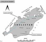
Cholistan (figure 1) is an extension of the Great Indian Desert, which includes the Thar Desert in Sindh province of Pakistan and the Rajasthan Desert in India, covering an area of 26,330 Km2, it lies within Southeast quadrant of Punjab province between 27o42' and 29o45' North latitude and 69o52' and 73o05' East longitude (Ahmad, 2005). The area was once green and prosperous, where cultivation was practiced. The source of irrigation was Hakra River (Akbar et al., 1996). With the drying up of the river, the area became desert through desertification processes and only few grazing lands were left.
PLANT GENETIC RESOURCES
Cholistan (table 1) is rich in vegetation resources, the projective aspect helps in soil binding, wind breakers and shelters belt establishment, while the inhabitants use productive aspect for themselves and their animals (Arshad and Rao, 1994).
The most common vegetation used as supplement of cereals are Cenchrus ciliaris, Cenchrus biflorus and Cenchrus prieurii. These grasses are very widely found and distributed in Cholistan. During the famine and drought years, the seeds of these grasses are grounded in flour and used as a supplement (Arshad et al., 1999).
The grains of Panicum antidotale, Panicum turgidum (Rao et al., 1989; Rao and Arshad, 1991; Arshad and Rao, 1994) are also consumed as food during the famine years. Panicum antidotale and Panicum turgidum are very drought resistant and found on the high sand dunes and perpetuated by their hardy rhizomes and seeds. They also protect themselves from overgrazing because of their hard and unpalatable stubble. The seeds of both species are ground and mixed with other cereals.
Indigofera argentea is a wild legume and mostly found during the monsoon on the top of very high sand dunes of Greater Cholistan. During the drought years, the seeds of this herbage are also ground and mixed with other cereals.
In Cholistan, a number of plants are used as vegetables. Capparis decidua locally called, ‘Karir’ is important perennial shrub, leafless, much branched and evergreen plant used as vegetables frequently.
Prosopis cineraria locally called, ‘Jandi’ is an excellent survivor of Cholistan desert. Camels, cows, goats and other animals browse it and give flowers and fruits during the month of March to May. The young green pods are cooked as vegetables in addition to fresh and preserved forms. The yellowish mature pods are sweetish in taste and are eaten directly.
Calligonum polygonoides locally called, ‘Phog’ is an abundantly growing plant species on the sand dunes. The flower buds of this plant locally called as ‘Phugusi’ are cooked in fresh form and also dried in sunlight for its later use. Caralluma edulis, locally known as ‘Settu or Pippu’ grown abundantly in the spiny bushes of Prosopis cineraria and Capparis decidua after monsoon rainfall. It is a very delicious vegetable of the season and people cook it directly. The inhabitants use the fruits of Capparis decidua, Zizyphus spina christi and Salvadora oleoides.
There are seeds of many indigenous species, which posses considerably a high percentage of oil. Citrulus colocynthis is a perennial trailing herb with fruit of sandy tract, containing 15 percent of pulp, 23 percent rind and 62 percent seeds (Sen, 1982). The seeds contain 21 percent of non-edible oil, whose paling is always brown in colour and very bitter in taste. Under natural conditions 50-80 creepers per hectare are recorded bearing 8 to 50 fruits per creeper. The oil obtained from this plant is used in the soap industry. It has high medical value for joint pains in human and stomach ailment in animals (Arshad et al., 1987).
Salvadora eleoides locally known as ‘Jal’ is evergreen, its small trees grow in habitats having medium to fine textured soil. The fruit of this plant is edible and liked very much by the local inhabitants. There are numerous aromatic plants in Cholistan, which contain essential oils having strong dour aromatic. The essential oils can be removed from the plant tissues and can be used in the perfumery and soap industries. The common species are Cymbopogon jwarancusa, Cymbopogon marttinni and Cyperus rotundus (Arshad and Rao, 1993).
The important plant species used as wind breakers and shelters belt are Prosopis juliflora (Valyati Kiker), Tamarix aphylla (Frash), Prosopis cineraria (Jandi) and Acacia nilotica (Kiker).
DEVELOPMENT OF UNDER-UTILIZED INDUSTRIAL AND MEDICINAL PLANTS
There are many desert plants in Cholistan, which are under-utilized, but have significant industrial and medicinal values. Similarly the new desert plant such as Simmondsia chinensis and Agave sp. should be tried here. Simmondsia chinensis is a drought resistant plant. It contains 45 to 55 percent lubricating oil known as liquid wax and is used in pharmaceutical industry. The Agave sp. produces 5-7% fibre which can be used for cordage, twine, carpet base etc. Development of such under-utilized plants and their marketing should be undertaken with the objective of providing alternative sources of income to the people of Cholistan. For instance, many new industrial processes can stimulate the need for a large supply of plant products like lubricating oils, waxes, pharmaceuticals etc. Some of these plants of economic value and their uses are given below (Arshad et al., 1987; Rao et al., 1989; Arshad and Rao, 1993):
a) Fibre plants
-
Leptadenia pyrotechnica (Khip),
-
Crotolaria burhia (Chag),
-
Agave sp.
-
Calotropis procera: Its stem contains 4-5% fine fibre
b) Oilseed (non-edible)
-
Citrullus colocynthis (Tumba): Contains 20% oil
-
Citrullus lanatus (Matera): Contains 20-30% oil
-
Simmondsia chinensis (Jojoba): Its seeds contain 45 to 55% lubricating oil
-
Salvadora oleoides (Jal)
-
Salvadora persica (Jal): Oil seed plant
-
Azadirachta indica (Neem)
-
Pongamia pinnatea (Pit papri)
-
Balanites aegyptiaca (Hingota)
c) Gums
Genus Acacia is the main source of gum in arid zones.
-
Acacia senegal: Produces gum
-
Acacia nilotica
-
Acacia leucophloea: Produces brown gum
-
Acacia cupressiformis: Produces red gum tears
-
Acacia tortilis
-
Prosopis juliflora: Produces black gum tears
d) Herbal plants
Some of the un-exploited desert flora of important medicinal value is given:
-
Cymbopogon jwarancusa (Khavi),
-
Cassia augustifolia (Senna),
-
Plantago ovata (Isabgol),
-
Datura innoxia (Datura),
-
Tribulus terrestris (Bakkari),
-
Commiphora wightii (Gugal),
-
Boswellia serrate (Salarn),
-
Solanum nigrum (Mako),
-
Cucurbita foetidissima (Buffalo gourd).
e) Pharmaceuticals
The following chemicals can be isolated from different desert flora. Isolation of such products of economic value should be taken up.
-
Diosgenin from Balanites roxburgii,
-
Scopolamine from Datura innoxia,
-
Cineole from Eucalyptus viridis,
-
Candelilla wax from Euphorbia antisyphilitica,
-
Essential oil from the leaves of Cymbopogon martinii,
-
Crude soda from Haloxylon recurvum.
f) Miscellaneous plants
-
Parthenium orgentaus (Guayule): All parts of the shrub contain rubber-like substance.
Soft wood species like Ailanthus excelsa and Moringo oleifera, if grown in Cholistan, can be used for feed the matchstick and paper industry. Similarly, some of the perennial desert grasses such as Panicum antidotale (Gramna), Saccharum munja (Munja), Heteropogon contortus have potential of being used in the paper industry (Arshad and Rao, 1994).
NATIVE PLANTS AS A SOURCE OF FOOD DURING FAMINE
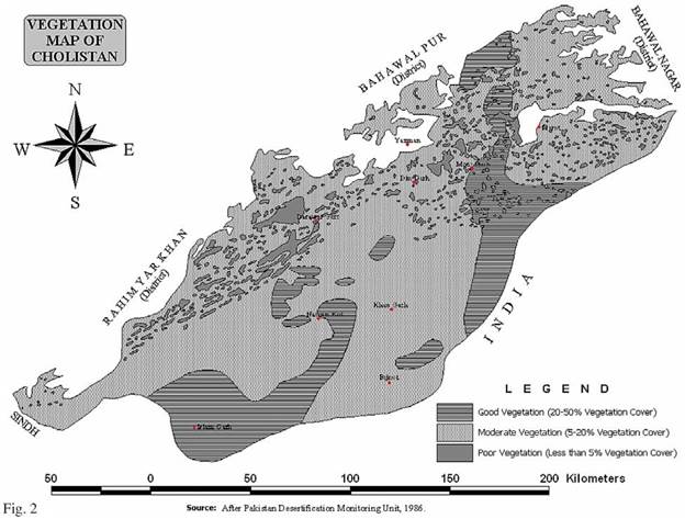
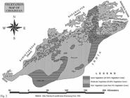
Desert dwellers, especially the nomadic communities of desert tracts, partially depend on natural vegetation (figure 2) and wild life species for their food during prolonged droughts and famines. They collect fruits, seeds, leafy material and roots of the native plants for consumption. Under extreme famine conditions even the bark of a hardy plant like Prosopis cineraria may be consumed. Experience of generations has taught them well how to survive under the harsh desert environment. Some of these native famine food plants are mentioned as under:
a) Wild fruits
Fruits of many native plants may be eaten raw, while those of others can be dried and preserved for future use, such as Zizyphus nummularia (Jangli beri), Cordia myxa (Lasoora), Cordia gharaf (Lasoori), Capparis decidua (Karir), Prosopis cineraria (Khejri), Salvadora oleoides (Pilu), Opuntia sp. (Thor), Azadirachta indica (Neem), Fiscus religiosa (Peepal), Fiscus bengalensis (Bargad), Acacia senegal (Kumat), Cucumis callosus (Kachra), Cucumis lanatus (Matera), etc.
b) Seeds
Seeds of some grasses like Cenchrus ciliaris (Dhaman), Cenchrus setigerus (Anjan or Damni), Cenchrus biflorus (Bhurat), Lasiurus sindicus (Sewan), Panicum antidotale (Gramna), Panicum turgidum (Murat) and Eleusine compressa (Tantia) can be collected and used with bajra grain as a suitable mixture. Seeds of creepers namely Citrullus colocynthis (Tumba), Citrullus lanatus (Matera) and those of a few legumes like Indigofera and Acacia species can also be consumed in different ways.
c) Leafy material
Leaves of herbs such as Achyranthus aspera, Gisekia Pharnacoides, Lencus aspera, Boerhavia diffusa and Boerhavia verticillata can be used after boiling.
d) Roots
The root tubers and rhizomes of desert plants are used during famines. Young roots of Butea monosperma (Dhak), Bombax cieba (Semal), Seropigia tuberosa (Khudala) are roasted and eaten raw. Swollen roots of Asparagus racemosus are also used. Rhizomes of Cyperus sp. (Motha) can be used after boiling under severe famine conditions.
KHIP - SILVER FIBRE OF CHOLISTAN DESERT
‘Khip’, Leptadenia pyrotechnica is an evergreen herb plant. In winter, the plant turns pale and dry, in rainy season again turns green. It requires sandy soil to grow. At the initial stage, its root growth is very quick and deeper probably more than its stem growth and depends on the type of soil. Its seed has silky coma, therefore are carried to a considerable distance by the wind. The healthy plant normally occupies 100 to 150 square feet of land. Its normal height is five to eight feet and we can take benefit preferably after two years of its plantation. ‘Khip’ plant belongs to xerophytic class and is a perennial plant. Every year new sprouts shoot up which have comparatively less wood and thicker bark, which bear fibre. The plantation of ‘Khip’ will not only changes the economy of the local people but also even changes the climatic conditions. The brackish water of Cholistan would be helpful in the growth of the plants because it does not spoil faster (Laghari, 1991). Its plantation season is launching of the monsoon and starts flowering in February. It bears pod full of seeds with silky coma. The seeds are matured in April and can be used for oil extracting. The stem of the plant after taking out fibre can be utilized in paper industry for making hard wood. ‘Khip’ is also used in pharmaceutical industry and ash of ‘Khip’ is used for removing kidney stones. ‘Khip’ is also used as fodder for camels and goats.
JOJOBA - AN ECONOMIC OILSEED PLANT
Besides, the fossil-fuel crisis and its scarcity, arid plants can be replaced as a source of raw material of petroleum and oil products in future. Many arid plants, such as jojoba, Atriplex spp. and local habitats like ‘pilu’, ‘khip’, ‘beri’, ‘khar’ etc. grow well on marginal dry and light textured soils and brackish water of drylands can be used for irrigation purposes. Jojoba is known as valuable specie of arid lands, its seeds contain 45 to 55 percent lubricating oil. Jojoba oil is used in cosmetics, pharmaceuticals and lubricant industries (Butt et al., 1991). The life of Jojoba plant is expected ranging from 100-150 years can tolerate and adjust with different adverse environments, i.e. extreme temperature, drought, salinity and frost except water logging.
GIS APPLICATION FOR ESTIMATION OF POTENTIAL AGRICULTURE
The use of spatial data for drylands resource management and planning has been recognized worldwide. However, the spatial data will be less useful if they are not transformable into information, which can be analyzed and interpreted in a systematic and quick ways. Hence there is a requirement to transfer and keep spatial data related to agriculture in a standard computer format preferably in a GIS environment (Khali, 2001). A GIS is an integrated resource data base system that has the capability to store, edit and process digital data; and that supports development planning and policy analysis (Aronoff, 1995). The use of GIS for evaluating the potential of drylands is becoming very important in which immense accumulation of data is unavoidable (Khali, 2001). The Ministry of Environment, Government of Pakistan has set up Environmental Monitoring System (EMS) combining NOAA AVHRR data with high resolution Landsat TM data (FAO, 1997) and ground observations with an objective to develop an operational GIS for more effective planning, management, conservation and sustainable development of resources (Alias, 2001).
GPS APPLICATION TO INVESTIGATE AGRICULTURAL COMPARTMENT
Global Positioning System (GPS) is a highly accurate satellite based radio navigation system providing three-dimensional positioning, velocity and time information. In order to achieve GPS co-ordinate readings, the GPS unit transmitter must detect a minimum of four satellites and the more satellites detected by the transmitter, the more accurate the readings tend to be. Better accuracy can also be achieved if differential GPS (DGPS) is used (Khali et al, 2001; Spencer et al, 2003). The idea behind the DGPS is to correct bias errors at one location with measured bias errors at a known position. A reference receiver, or base station, computes corrections for each satellite signal. Some of the potential and useful GPS applications in drylands resources include tree location mapping, potential agricultural compartment boundary survey, ground truth activities and resources inventory (Khali, 2001).
GPS FOR TREE MAPPING
Using GPS as a tool to map tree location is becoming very important (Zarchan, 1996). Tree mapping utilizes both qualitative and quantitative data collection techniques in order to create a database containing the spatial location and attributable information of the trees (Khali et al, 2001; Kennedy, 2002). Pakistan Forest Institute (PFI) has successfully developed tree location information and other tree biophysical information including species, diameter at breast height, height and tree conditions were also recorded for ecological rehabilitation in drylands of Pakistan. These information were combined in a GIS database and specific computer programming was done to develop Environmental Monitoring System (FAO, 1997).
A preliminary study was carried out to test the suitability of GPS for mapping (Spencer et al, 2003). A DGPS technique involving the use of two GPS; a stationary based station receiver left at known reference location and a “rover” receiver used in the field to map the tree location was used to locate the tree position. The tree location information was transferred into agricultural compartment map in a GIS database system (Khali et al, 2001). The study indicates that DGPS can be used to determine tree position in the natural agricultural environment.
REMOTE SENSING APPLICATION FOR MONITORING OF AGRICULTURE
Space technology, through satellite remote sensing, has found a very valuable application in drylands resource management not only for resource surveys, but also for studying the role of agriculture in maintaining ecological balances and elucidating their impact on global climate (Rao, 1990). Satellite remote sensing contributed to the various aspects of drylands resource management, such as land use or land cover mapping and monitoring changes (Hussin, 2000), evaluation of ecosystem, estimation of biomass, carbon flux and productivity, and the feasibility of developing an integrated information system. Remote sensing systems collect information about objects without coming into physical contact with it; in earth observation the most important medium to transmit this information is electromagnetic radiation in the optical and microwave region. Major advantages result from its synoptic nature, comprehensive spatial information and objective, repetitive coverage. While remote sensing has initially been used primarily for resource mapping and inventory it turns out that monitoring and predictive modelling is becoming more important and successful. Remote-sensing systems, and in particular Earth observation satellites, provide significant contributions to detecting deforestation, land degradation, land cover assessment and monitoring, particularly by providing methodological pathways for scaling up the results of field investigations and by supplying the spatial information needed for regional-scale analyses.
Besides airborne systems for individual surveys on local to regional scale, several geostationary and polar-orbiting satellites (e.g., METEOSAT/GOES, NOAA-AVHRR, Landsat, SPOT-HRV and VEGETATION, IKONOS) are available which operate in the reflective and emissive domain and can be used for regional to global assessments. As continuity for most operational remote sensing systems seems guaranteed they can be used for continuous environmental monitoring but also for retrospective studies on environmental change that has occurred in the past. In the future, one can expect that remote sensing systems with increased spectral resolution as well as active or passive microwave sensors may further increase application perspectives (Rao et al, 1991).
It is widely agreed that land degradation in arid, semi-arid and dry sub-humid ecosystems is not necessarily driven by climatological variables but frequently triggered by processes which result from adverse human impact on these fragile ecosystems. The productivity of drylands systems largely depends on surface properties which, as they control water availability, the spontaneous emergence and development of new plants and dust production during wind storms, might dominate climatic variables. Our ability to draw concise conclusions with respect to land resources and environmental change will thus depend on the capability to assess not only vegetation conditions (i.e., cover, structure, biomass) but also specific surface characteristics (i.e., parent material and soil substrate, including mineralogical and biologic crusting) from remote sensing data. Resource assessments and continuous monitoring of environmental parameters are complementary issues to be observed for a sustainable management of drylands ecosystems (Alias, 2001). It seems obvious that the identification of degraded areas in the sense of environmental inventories provides the fundamental basis for better understanding the processes of deforestation and land degradation in their spatial context. It is essential to monitor both, namely soil conditions and the disturbance regime of plant communities over time, including their successional recovery. The integrated interpretation of the satellite-derived information layers, available climatic records and results from detailed field studies may provide new perspectives to understand environmental change in arid ecosystems.
CONCLUSION
The analysis of Cholistan desert resources help us to know that the desert tract is full of plant resources, which have not been exploited on a large scale or commercial basis, because of their low output, sparse distribution and very poor management. For the overall development of the desert, it is an urgent need that the existing plant resources should be exploited on sound scientific lines using modern technologies.
Because of a traditionally limited approach to dryland management, development, and assessment, current dryland initiatives fail to build the support necessary to effectively accomplish their objectives. On the other hand, an ecosystem approach to drylands monitoring and assessment holds great promise for generating enthusiasm, precisely because of its more comprehensive, forward-looking focus.
ACKNOWLEDGEMENTS
The author wishes to thank Dr. Mohammad Arshad, Cholistan Institute of Desert Studies, Islamia University Bahawalpur, for providing technical assistance during the field study of Cholistan desert and valuable comments on a draft-version of this paper.
REFERENCES
- Ahmad, Farooq (2005), “ Historical and archaeological perspectives of soil degradation in Cholistan”, Journal Geographic, Issue No. 10, pp. 31-35.
- Akbar, G., Khan, T. N., and Arshad, M. (1996), “Cholistan desert, Pakistan”, Rangelands, Vol. 18(4), pp.124-128.
- Alias, A. M. (2001), “Application of remote sensing and GIS by Forestry Department, Peninsular Malaysia - Current Status”, Paper presented at the seminar “Teknologi Remote Sensing dan GIS dalam Aplikasi Perhutanan” Kuala Lumpur, 31 July 2001. pp.10
- Aronoff, S. (1995), “Geographic Information Systems: A Management Perspective”, WDL Publications, Ottawa, Canada.
- Arshad, M., and Rao, Altaf-ur-Rehman (1993), “Plant genetic resources of Cholistan desert and their utilization”, Cholistan Institute of Desert Studies, Islamia University Bahawalpur, Pakistan.
- Arshad, M., M. S., Chaudhry and Akram, M. (1987), “Important indigenous and exotic trees, shrubs and grasses and their utilization in Cholistan desert”, Cholistan Institute of Desert Studies, Islamia University Bahawalpur, Pakistan.
- Arshad, M., Rao, Altaf-ur-Rehman (1994), “Flora of Cholistan desert”, Cholistan Institute of Desert Studies, Islamia University Bahawalpur, Pakistan.
- Arshad, M., Rao, Altaf-ur-Rehman, Akbar, G., and Khan, M.A. (1999), “Floral wealth and its adaptation in degraded Cholistan”, Proceedings of an International Conference on Desertification and Soil Degradation, 11-15 November 1999, Moscow, pp.195-199.
- Butt, M. Anwar, Akram, M., Abdullah, M. (1991), “Jojoba - an economic oilseed plant for deserts with special reference to Cholistan”, Proceedings of seminar “People’s participation in the management of resources in arid lands”, Cholistan Institute of Desert Studies, Islamia University Bahawalpur, Pakistan, pp.72-78.
-
FAO (1997), “FAO activities: Forestry and Fisheries applications. http://www.fao.org/WAICENT/FAOINFO/SUSTDEV/EIdirect/EIre0025.htm, Food and Agriculture Organization of the United Nations, Rome.
» http://www.fao.org/WAICENT/FAOINFO/SUSTDEV/EIdirect/EIre0025.htm - Hussin, Y. A. (2000), “State of The Art: remote sensing application for sustainable management of forests”, Proceedings of the 20th ACRS Conference, pp.6.
- Kennedy, Michael (2002), “The Global Positioning System and GIS: An Introduction” 2nd Edition, Taylor & Francis, New York.
- Khali Aziz, H. (2001), “Remote sensing, GIS and GPS as a tool to support precision forestry practices in Malaysia”, Proceedings of the 22nd Asian Conference on Remote Sensing, 5-9 November 2001, Singapore.
- Khali Aziz, H., Ibrahim, S., and Norizan, A. P. (2001), “Tree mapping using Differential Global Positioning System (DGPS) - A step towards precision forestry”, Paper presented at the seminar “Teknologi Remote Sensing dan GIS dalam Aplikasi Perhutanan”, Kuala Lumpur, July 31, 2001. pp.10
- Laghari, Sardar Najmud Din Khan (1991), “Khip - silver fibre of Cholistan desert”, Proceedings of seminar “People’s participation in the management of resources in arid lands”, Cholistan Institute of Desert Studies, Islamia University Bahawalpur, Pakistan, pp. 24-29.
- Rao, Altaf-ur-Rehman, Arshad, M. (1991), “Perennial grasses of Cholistan desert and their distribution”, Proceedings of seminar “People’s participation in the management of resources in arid lands”, Cholistan Institute of Desert Studies, Islamia University Bahawalpur, Pakistan, pp.6-11.
- Rao, Altaf-ur-Rehman, Arshad, M., and Mohammad, Shafiq (1989), “Perennial grasses germplasm of Cholistan desert and its phytosociology”, Cholistan Institute of Desert Studies, Islamia University Bahawalpur, Pakistan.
- Rao, D. P., Gautam, N. C., Karale, R. L. and Baldev, Sahai (1991), “IRS IAApplication for Land use/Land Cover Mapping in India”, Current Science Vol. 61 (3, 4) Remote Sensing for National Development, India.
- Rao, U. R. (1990), “Space and forest management”, Proceedings of the 41st IAF Congress, Dresden, Germany. 1990.
- Sen, D. N. (1982), “Environment and plant life in Indian desert”, Geobios International, Jodhpur, India.
- Spencer, J; Frizzelle, B. J; Page, P. H., and Vogler, J. B. (2003), “Global Positioning System: A field guide for the social sciences”, Blackwell Publishing Ltd
- Zarchan, Paul (1996), “Global Positioning System: Theory and Application”, Volume I, American Institute of Aeronautics and Astronautics, Inc., Washington D.C.