
 Influence of Land Use and Land Cover on the Water Cycle in Ouro Preto, MG: Contributions to Water Resource Management
Abstract
Water is an essential element for life, and its territorial management is crucial to ensure universal access while maintaining both quality and quantity. Poorly planned landscape interventions intensify problems such as erosion, siltation, flooding, landslides, and potable water scarcity. Among the key processes for water resource management, surface runoff and infiltration stand out, both directly influenced by land use and land cover (LULC) changes. This study aimed to evaluate the impacts of LULC modifications between 2002 and 2022 on surface runoff and infiltration rates in the municipality of Ouro Preto, Minas Gerais, Brazil. Runoff coefficients were first estimated based on slope maps, soil classes, and LULC for 2002 and 2022. Subsequently, runoff maps were generated by multiplying these coefficients by average precipitation. Infiltration maps were then derived using the water balance method, subtracting runoff and evapotranspiration. Geoprocessing was conducted in a GIS environment using remote sensing data within the QGIS platform. Results indicate an increase in surface runoff and a decrease in infiltration, especially in the western, northern, and central portions of the municipality. This is concerning, as the lowest infiltration rates coincide with high-potential aquifers, threatening their recharge. Furthermore, the increase in runoff exacerbates erosion risks, particularly in the central region, where soils are highly susceptible to gully formation.
Keywords:
Hydrological Modeling; Geographic Information System; Water Balance; Surface Runoff; Aquifer Recharge
Resumo
A água é um elemento essencial à vida e a sua gestão nos territórios é necessária para garantir que seja universalmente acessível e para manter a sua qualidade e quantidade. Intervenções mal planejadas na paisagem intensificam problemas relacionados à erosão, assoreamento, enchentes, deslizamentos e escassez de água potável. Entre os processos essenciais para a gestão dos recursos hídricos destaca-se o escoamento superficial e a infiltração, que são influenciados diretamente pelas modificações no uso e cobertura da terra. Dessa forma, o objetivo do presente estudo foi analisar os efeitos das mudanças no uso e cobertura da terra ocorridas entre 2002 e 2022 sobre as taxas de escoamento superficial e de infiltração no município de Ouro Preto, MG. Inicialmente, foi estimado o coeficiente de escoamento com base nos mapas de declividade, classes de solo e uso e cobertura da terra de 2002 e 2022. Posteriormente, foi elaborado o mapa de escoamento multiplicando o coeficiente pela precipitação média anual. Finalmente, foi elaborado o mapa de infiltração utilizando o cálculo do saldo de água, subtraindo o escoamento e a evapotranspiração. O geoprocessamento foi feito em plataforma SIG com dados de sensoriamento remoto utilizando o software QGIS. Os resultados indicam aumento da taxa de escoamento superficial e diminuição da infiltração, principalmente na porção oeste, norte e central do município. Situação preocupante considerando que as menores taxas de infiltração estão sobre aquíferos de grande potencial, prejudicando a sua recarga. O aumento das taxas de escoamento intensifica os problemas de erosão, situação especialmente alarmante na região central, onde o solo é propício para a ocorrência de voçorocas.
Palavras-chave:
Modelagem Hidrológica; Sistema de Informação Geográfica; Balanço Hídrico; Escoamento Superficial; Recarga de Aquíferos
INTRODUCTION
Despite the abundant availability of water resources in Brazil, their management is inefficient and conflictual (Peixoto et al., 2021). Much of this water is used in the production of commodities such as iron ore, which in 2021 led national exports, exceeding US$ 44.6 billion, of which US$ 18.2 billion came from Minas Gerais (Ministério da Economia, 2022). In the Quadrilátero Ferrífero (QF - Iron Quadrangle), the main iron ore producing region in Minas Gerais, water management is complex, and the conflict with mining aggravates the situation, since the geological formations that house the main deposits also contain aquifers that are fundamental to regional water security (Souza, 2021; Miguel; Campos, 2024). In this context, the municipality of Ouro Preto, located in the southeastern portion of the QF, faces a complex dilemma in attempting to reconcile urban expansion and mining activity with the conservation of its water resources.
Changes in land use and land cover affect the hydrological cycle, modifying flow patterns and soil hydraulic properties, which impact runoff and infiltration rates (Mahmoud; Alazba, 2015; Savary et al., 2009; Yang et al., 2021). These hydrological processes are crucial because they influence erosion and siltation rates, agricultural productivity (Quinton; Catt, 2006), the occurrence of floods (Wheater; Evans, 2009), the conservation of groundwater reserves, and the flow of watercourses (Jukić; Denić-Jukić, 2009). Thus, analyses that estimate the effects of changes in land use and land cover on surface runoff and infiltration rates are fundamental to water resource management (Delgado et al., 2020; Frey et al., 2021).
Several numerical methods and models have been developed to estimate surface runoff and infiltration (Scanlon et al., 2002). The high demand for spatial data and processing time has led to the development of simplified tables and formulas, widely used in regions with scarce data or in large-scale analyses, which estimate the runoff coefficient based on slope, soil permeability, and land use and cover (D’Alberto; Lucianetti, 2019). Other models integrate the water balance based on surface runoff, precipitation, and evapotranspiration data to estimate infiltration (Costa et al., 2019; Galvão et al., 2018). These models now incorporate remote sensing data and processing in Geographic Information Systems (GIS), given the wide availability of spatial, spectral, radiometric, and temporal data (Thakur et al., 2016).
However, despite the existence of several hydrological modeling studies, there is a significant gap in the literature regarding the analysis of long historical series in the Quadrilátero Ferrífero, with a specific focus on the municipal scale. This approach is essential, as it is at the municipal level that many land use decisions are made. Thus, this article aimed to analyze how changes in land use and land cover between 2002 and 2022 affected surface runoff and infiltration rates in the municipality of Ouro Preto, MG. The hypothesis raised is that the removal of native vegetation cover in favor of urban expansion and mining areas has resulted in a significant increase in surface runoff and a consequent reduction in infiltration capacity, compromising local water resilience. The results aim to provide technical support for more efficient and sustainable water resource management in the region.
MATERIALS AND METHODS
Characterization of the study area
Ouro Preto is located in the extreme southeast of the Quadrilátero Ferrífero and the São Francisco Craton (Almeida, 1977). It covers an area of 1,245 km² comprising 13 districts and approximately 75,000 inhabitants, with the urban area representing 1.5% of the territory (18.8 km²) in 2022 (Souza et al., 2020; IBGE, 2022). It is located in a transition region between the Atlantic Forest and Cerrado biomes, where seasonal forests and rupestrian grasslands predominate (Messias et al., 2015). According to the Köppen and Geiger classification, the climate is Cwb (subtropical highland), with dry winters and a rainy season from November to March (Nimer, 1989).
The municipality has complex geology, composed of four main lithostratigraphic complexes: the Bação Metamorphic Complex, with Archean granite-gneiss basement; the Rio das Velhas Supergroup, an Archean volcanic-sedimentary sequence of the “greenstone belt” type; the Minas Supergroup and the Itacolomi Group, Paleo- and Mesoproterozoic metasedimentary sequences (Ruchkys, 2007; Varajão et al., 2009). In the south, the following units were mapped: Metamorphic and Metaultramorphic Units, Monsenhor Isidro Body, and Alto Maranhão Suite (Figure 1).

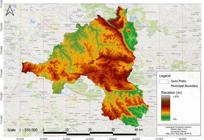
This lithological complexity is reflected in a rugged terrain, with altitudes ranging from 666 to 1,898 meters (Figure 2). The elevated areas are composed of itabirites and quartzites from the Minas Supergroup and the Itacolomi Group; the intermediate regions consist mainly of schists, phyllites, and friable quartzites from the Minas and Rio das Velhas supergroups; and the lower regions consist of gneisses (Varajão et al., 2009).
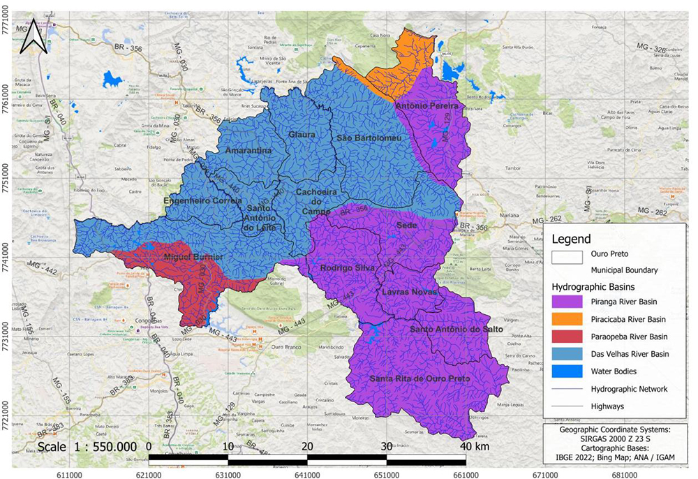
The territory is drained by two large basins, the São Francisco River basin-which covers the Das Velhas River and Paraopeba River basins-and the Doce River basin-which covers the Piranga River and Piracicaba River basins (Figure 3). The regional geological and geomorphological heterogeneity favors the occurrence of soils with significant variation in depth, texture, and structure, which were grouped into six classes on the soil map of Minas Gerais: Red-Yellow Latosol, Red Latosol, Red Argisol, Litholic Neosol, Haplic Cambisol, and Rock Outcrop (UFV et al., 2010).

Input data and modeling methodology
Surface runoff was calculated by multiplying the average annual rainfall by a runoff coefficient, estimated using map algebra based on the integration of data on slope, soil permeability, and land use. Infiltration was obtained using the water balance equation (Rushbrook; Pugh, 1999), deducting surface runoff and evapotranspiration from total precipitation.
Surface runoff coefficient
Various methods for calculating surface runoff based on geomorphological, pedological, and land use and land cover data were organized into a reference matrix (Table 1). The coefficients proposed by Kenessey (1930) and Barazzuoli et al., (1989) were used because they cover higher slope ranges that are more appropriate for the mountainous terrain of the region, and by Liu (2004), which covers the soil textures found in the area. To define the coefficients in urban areas, the parameters of ASCE and WPCF (1986) and Rahaman (2021) were adopted.
Soil permeability map
The six soil classes mapped by UFV et al., (2010) (Figure 4A) were reclassified according to permeability (Figure 4B). In the absence of primary hydraulic conductivity data, a database was created with soil samples obtained from regional research (Andrade et al., 2012; Costa et al., 2014; Bonna, 2011; Vale, 2013; Souza, 2013). These samples were plotted on the triangular diagram of texture classes (Lemos; Santos, 1996) to determine the predominant texture of each soil class. Following Liu's methodology (2004), predominantly sandy loam soils were considered to be highly permeable; sandy clay loam soils were considered to be moderately permeable; and clay soils were considered to be low permeability. The rocky outcrops were classified as having very low permeability due to the frequent occurrence of rock fragments and lateritic layers in mosaics near Neosols and rocky fields (Messias et al., 2013). This classification valued the greater permeability of Neosols and Cambisols and, consequently, of higher elevation areas, which are home to a significant portion of the springs.

A - Soils in the municipality of Ouro Preto, MG. B - Soil permeability map of the municipality of Ouro Preto, MG
Slope map by digital elevation model
The slope map (Figure 5A) was derived from the SRTM V3 Digital Elevation Model (30 m resolution), subsequently reclassified into four intervals according to Barazzuoli et al., (1989): flat (<3.5%); slightly sloped (3.5%-10%); sloping (10%-35%); and very steep (>35%) (Figure 5B).

A - Slope angle (%) of the municipality of Ouro Preto, MG. B - Slope angle classes in the municipality of Ouro Preto, MG
Land use and land cover map for 2002 and 2022
Data from MapBiomas Collection 7 (Landsat 5, 30 m) were used for the years 2002 and 2022. The original classes were regrouped into five categories according to surface runoff capacity (Liu, 2004): Forest/Savanna/Forestry (very low runoff); Pasture/Grassland (low runoff); Agriculture (medium runoff); Bare Land/Mining (high runoff); and Urbanized Area (very high runoff) (Figure 6).
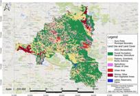
Land use and land cover classes according to surface runoff capacity in the municipality of Ouro Preto, MG, in 2022
Precipitation map
The precipitation map used the historical series from the Climate Hazards Group InfraRed Precipitation with Station data (CHIRPS), which integrates satellite images (0.05º) with data from weather stations (Funk et al., 2015). The annual average of the time series (2002 to 2022) was calculated, followed by resampling to 30 m, a procedure necessary to avoid the loss of geomorphological and urban detail and enable map algebra (Figure 7).

Actual evapotranspiration map
Evapotranspiration was estimated using the MOD16A2GF Version 6.1 (Penman-Monteith) model, which combines meteorological reanalysis data with remote sensing, integrating soil evaporation and canopy transpiration (Running et al., 2021). The model was selected because it provides greater spatial detail (500 m) and better land use distinction compared to FLDAS (Silva et al., 2021). The average evapotranspiration of the time series (2002 to 2022) was obtained, with subsequent resampling to 30 m (Figure 8).

Runoff and infiltration map
Soil permeability layers, slope, and land use and land cover were combined according to Table 1 to determine the surface runoff coefficient for each pixel. This coefficient was multiplied by the average annual precipitation, generating surface runoff maps (mm/year) for the 2002 and 2022 scenarios.
Infiltration was estimated by adapting the water balance equation of Rushbrook and Pugh (1999):
-
Where:
- I = infiltrated volume (including moisture stored in the soil and percolated water)
- P = precipitated volume
- ET = evapotranspired volume
- R = surface runoff volume
Limitations of the Method
It should be noted that the model adopts simplifications necessary for the regional scale analyzed. It was decided to consider infiltration as a whole, including water stored in the soil and percolated water, due to soil heterogeneity and the lack of specialized data on the hydraulic characteristics of local soils, a gap that also required the generalization of permeability classes based on secondary data. Another limitation lies in the absence of field validation, which is not feasible due to the lack of historical hydrographs in the micro-basins and operational restrictions on in situ measurement campaigns. The model therefore proposes a simplified representation of reality to predict territorial management impacts, indicating spatial trends rather than absolute hydrological values.
RESULTS AND DISCUSSION
The integrated analysis of land use changes and their hydrological impacts between 2002 and 2022 demonstrates significant quantitative impacts on the water cycle in Ouro Preto.
Land Use and Land Cover
Data from MapBiomas (2002-2022) show a significant transformation in the landscape of Ouro Preto (Souza et al., 2020). Noteworthy is the reduction in native forest cover, a considerable part of which has probably been converted to eucalyptus monocultures, as indicated by the significant 255% increase in forestry areas (Table 2). The 40% expansion in intensive anthropogenic use classes (mining and urban) directly affects the local water balance. These changes do not occur uniformly, but are concentrated in areas of economic pressure: the northwestern mining axis (Antônio Pereira/Miguel Burnier) and the central urbanization axis around the BR-356 highway (Cachoeira do Campo/Amarantina). This dynamic confirms the pressure of extractive activities and population density on the territory, promoting the sealing of potential recharge areas.
Surface Runoff
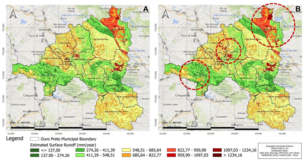
The increase in surface runoff rates validates the initial hypothesis of this study, that the change in land cover resulted in an increase in surface runoff between 2002 and 2022 (Figure 9). The maps highlight critical areas: in the northern and western portions (Antônio Pereira and Miguel Burnier), where increased runoff is directly associated with soil exposure due to mining; in the central portion (Cachoeira do Campo and Amarantina), the main factor is urbanization. The estimated surface runoff values are high compared to other studies (Mahmoud; Alazba, 2015; Tilahun; Merkel, 2009), probably due to the mostly sloping terrain and high precipitation rates. Although the 30 m resolution and the absence of in situ calibration impose limitations on the accuracy of the estimated values, the upward trend is clear and indicates the risk of intensification of erosion and gully formation processes, phenomena that are already recurrent due to the characteristics of the soil in the region (Bonna, 2011; Pedrosa, 2013).

A - Surface runoff in the municipality of Ouro Preto, MG, in mm/year in 2002, and B - in 2022
Infiltration
The reduction in estimated infiltration (Figure 10) exposes a latent socioeconomic and environmental conflict in the Quadrilátero Ferrífero: the geological formations of greatest mineral interest coincide with the main underground water reserves (Souza, 2021). The northern area, where infiltration was particularly low, is home to important aquifers in the municipality: the Itabira Group, which, especially in the Cauê Formation, has high storage capacity and conductivity (Mourão, 2007); the Piracicaba and Sabará Groups, which have high porosity, permeability, and storage coefficient; and the Itacolomi Group, formed by fractured aquifers that normally have high transmissivity coefficients (Ferreira; Bacellar, 2010). A similar situation regarding aquifer potential occurs in the western part of the municipality, where there was also a notable reduction in the infiltration rate (Figure 11). Other areas with low to medium infiltration include the central-eastern portion, located mainly on rocks from the Piracicaba and Sabará Groups, an important catchment area for the city's water supply.

A - Estimated infiltration in the municipality of Ouro Preto, MG, in mm/year in 2002, and B - in 2022
The difference in total infiltration between 2002 and 2022 indicates that, annually, approximately 1.23 billion liters of water no longer infiltrated the system, instead becoming surface runoff. The areas with the greatest loss of infiltration are clearly shown in Figure 11. This result corroborates the hypothesis of compromised recharge, aligning with the findings of Barbedo et al., (2022) on the decrease in water storage in Minas Gerais between 2003 and 2020.
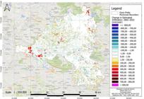
Difference in estimated infiltration rate between 2002 and 2022 for the municipality of Ouro Preto, MG, in mm/year
This decrease in groundwater recharge, combined with the lowering of the water table and the removal of water-storing lithological formations (to deepen mining pits), as well as population growth and increased water demand, compromises the resilience of aquifers. If current trends of urban expansion and mining over recharge areas persist, a scenario of increasing water insecurity is projected, affecting springs and watercourses essential to the Doce and Velhas river basins and, consequently, municipal supply and water availability in the Belo Horizonte Metropolitan Region.
FINAL REMARKS
This study demonstrates that land use and land cover changes in Ouro Preto between 2002 and 2022 resulted in measurable hydrological impacts, specifically increased surface runoff and reduced infiltration capacity. These changes intensify environmental degradation by increasing water erosion, silting of water bodies, and decreasing aquifer recharge, which directly weakens the base flow of springs.
Spatial analysis has shown that infiltration reduction occurs critically in areas of high hydrogeological suitability (itabiritic and quartzitic aquifers), signaling a compromise to local water security if current occupation trends continue. The scientific contribution of this work lies in the application of an accessible methodological approach to municipal water management, even in areas with low data availability, and in the analysis of a long historical series (20 years) in the Quadrilátero Ferrífero. This demonstrates the applicability of hydrological models in GIS for the diagnosis of complex basins, even in the face of limitations such as the use of secondary data and the absence of in situ calibration. However, it should be noted that more accurate estimates depend on future research that maps the hydraulic characteristics of regional soils (texture, depth, saturation capacity) and performs field calibration of runoff coefficients for different soil classes, slopes, and land uses.
It can be concluded that the integration of hydrological variables into land management is essential for water security in Ouro Preto. It is recommended that the maps generated in this study be used to support the revision of the Master Plan and the Land Use and Occupancy Law, guiding water resource management with priority given to the conservation of remaining recharge areas, in order to ensure resilience in the face of future economic and climatic pressures.
ACKNOWLEDGEMENTS
The authors would like to thank Raquel Rossini for her excellence and support in the English translation of this manuscript.
DATA AVAILABILITY
The data that support the findings of this study can be mad
References
-
ALMEIDA, F. F. M. de. O Cráton de São Francisco. Revista Brasileira de Geociências, v. 7, p. 349-364, 1977. https://doi.org/10.25249/0375-7536.1977349364
» https://doi.org/10.25249/0375-7536.1977349364 -
ASCE - AMERICAN SOCIETY OF CIVIL ENGINEERS; WPCF - WATER POLLUTION CONTROL FEDERATION. Design and construction of sanitary and storm sewers. New York: American Society of Civil Engineers, p. 1 - 332, 1986 (Reimpressão de 1969). Disponível em: https://ahmadsana.tripod.com/Courses/project1/sewer-specs.pdf Acesso em: 4, fev. 2026.
» https://ahmadsana.tripod.com/Courses/project1/sewer-specs.pdf -
ANDRADE, L. N.; LEITE, M. G. P.; BACELLAR, L. A. P. Composição mineralógica e geoquímica dos solos do Parque Estadual do Itacolomi - Ouro Preto/MG. Quaternary and Environmental Geosciences, v. 3, 2012. https://doi.org/10.5380/abequa.v3i1-2.16838
» https://doi.org/10.5380/abequa.v3i1-2.16838 -
BARAZZUOLI, P.; IZZO, S.; MENICORI, P.; MICHELUCCINI, M.; SALLEOLINI, M. A new practical aid to regional hydrogeologic planning: the runoff coefficient map. Environmental Management, v. 13, n. 5, p. 613-622, 1989. https://doi.org/10.1007/bf01874967
» https://doi.org/10.1007/bf01874967 -
BARBEDO, R.; FLEISCHMANN A. S.; SIQUEIRA, V.; BRÊDA, J. P.; MATTE, G.; LAIPELT, L.; AMORIM, A.; ARAÚJO, A. A.; FUCKNER, M.; MELLER, A.; FAN, F. M.; COLLISCHONN, W.; RUHOFF, A.; PAIVA, C. D. de. Water storage variability across Brazil. Revista Brasileira de Recursos Hídricos, v. 27, e32, 2022. https://doi.org/10.1590/2318-0331.272220220077
» https://doi.org/10.1590/2318-0331.272220220077 -
BARFIELD, B. J.; WARNER, R. C.; HAAN, C. T. Applied Hydrology and Sedimentology for Disturbed Areas. Oklahoma Technical Press, Stillwater, Oklahoma, p. 12-49, 1983. Disponível em: https://semspub.epa.gov/work/05/224351.pdf Acesso em: 4, fev.2026.
» https://semspub.epa.gov/work/05/224351.pdf -
BONNA, J. L. Mapeamento pedológico e de suscetibilidade erosiva no Alto Córrego Prata (Ouro Preto-MG). 2011. Dissertação (Mestrado em Geografia) - Universidade Federal de Minas Gerais, Belo Horizonte, 2011. Disponível em: http://hdl.handle.net/1843/MPBB-8RBKKX Acesso em: 4, fev. 2026.
» http://hdl.handle.net/1843/MPBB-8RBKKX -
COSTA, A. M. da; SALIS, H. H. C. de; VIANA, J. H. M.; LEAL PACHECO, F. A. Groundwater recharge potential for sustainable water use in urban areas of the Jequitiba River Basin, Brazil. Sustainability, v. 11, n. 10, p. 2955, 2019. https://doi.org/10.3390/su11102955
» https://doi.org/10.3390/su11102955 -
COSTA, S. Â. D.; KER, J. C.; SIMÕES, D. F. F.; FONTES, M. P. F.; FABRIS, J. D.; ANDRADE, F. V. Pedogênese e classificação de latossolos desenvolvidos de itabiritos no Quadrilátero Ferrífero, MG. Revista Brasileira de Ciência do Solo, v. 38, n. 2, p. 359-371, 2014. https://doi.org/10.1590/S0100-06832014000200001
» https://doi.org/10.1590/S0100-06832014000200001 -
CPRM - SERVIÇO GEOLÓGICO DO BRASIL; CODEMIG. Mapas geológico e de recursos minerais do estado de Minas Gerais. Belo Horizonte: CPRM, 2014. Escala 1:1.000.000. Disponível em: https://rigeo.sgb.gov.br/handle/doc/20786 Acesso em: 4, fev. 2026.
» https://rigeo.sgb.gov.br/handle/doc/20786 -
D’ALBERTO, L.; LUCIANETTI, G. Misinterpretation of the Kenessey method for the determination of the runoff coefficient: a review. Hydrological Sciences Journal, 2019. https://doi.org/10.1080/02626667.2019.1578965
» https://doi.org/10.1080/02626667.2019.1578965 -
DELGADO, M. I.; CAROL, E. S.; CASCO, M. A. Land-use changes in the periurban interface: Hydrologic consequences on a flatland-watershed scale. Science of The Total Environment, v. 722, 2020. https://doi.org/10.1016/J.SCITOTENV.2020.137836
» https://doi.org/10.1016/J.SCITOTENV.2020.137836 -
FARR, T. G.; ROSEN, P.A.; CARO, E.; CRIPPEN, R.; DUREN, R.; HENSLEY, S.; KOBRICK, M.; PALLER, M.; RODRIGUEZ, E.; ROTH, L.; SEAL, D.; SHAFFER, S.; SHIMADA, J.; UMLAND, J.; WERNER, M.; OSKIN, M.; BURBANK, D.; ALSDORF, D. The shuttle radar topography mission. Reviews of Geophysics, v. 45, n. 2, 2007. https://doi.org/10.1029/2005RG000183
» https://doi.org/10.1029/2005RG000183 -
FENN, D. G.; HANLEY, K. J.; DEGEARE, T. V. Use of the water balance method for predicting leachate generation from solid waste disposal sites. US Environmental Protection Agency, Report No. EPA/530/SW168, 1975. Disponível em: https://nepis.epa.gov/Exe/ZyPURL.cgi?Dockey=9100OH2M.txt Acesso em: 4, fev. 2026.
» https://nepis.epa.gov/Exe/ZyPURL.cgi?Dockey=9100OH2M.txt -
FERREIRA, Q. C. G.; BACELLAR, L. A. P. Avaliação preliminar das condições hidrogeológicas na área do município de Ouro Preto, MG. Geonomos, v. 18, p. 13-21, 2010. https://doi.org/10.18285/geonomos.v18i1.63
» https://doi.org/10.18285/geonomos.v18i1.63 -
FREY, S. K.; MILLER, K.; KHADER, O.; TAYLOR, A.; MORRISON, D.; XU, X.; BERG, S. J.; HWANG, H. T.; SUDICKY, E. A.; LAPEN, D. R. Evaluating landscape influences on hydrologic behavior with a fully-integrated groundwater-surface water model. Journal of Hydrology, v. 602, n. 126758, 2021. https://doi.org/10.1016/j.jhydrol.2021.126758
» https://doi.org/10.1016/j.jhydrol.2021.126758 -
FUNK, C.; PETERSON, P.; LANDSFELD, M.; PEDREROS, D.; VERDIN, J.; SHUKLA, S.; HUSAK, G.; ROWLAND, J.; HARRISON, L.; HOELL, A.; MICHAELSEN, J. The climate hazards infrared precipitation with stations: a new environmental record for monitoring extremes. Scientific Data, v. 2, n. 150066, 2015. https://doi.org/10.1038/sdata.2015.66
» https://doi.org/10.1038/sdata.2015.66 -
GALVÃO, P.; HIRATA, R.; CONICELLI, B. Estimating groundwater recharge using GIS-based distributed water balance model in an environmental protection area in the city of Sete Lagoas (MG), Brazil. Environmental Earth Sciences, v. 77, n. 10, 2018. https://doi.org/10.1007/s12665-018-7579-z
» https://doi.org/10.1007/s12665-018-7579-z -
IBGE. Censo Demográfico 2022: Ouro Preto (MG). Instituto Brasileiro de Geografia e Estatística, 2022. Disponível em: https://cidades.ibge.gov.br/brasil/mg/ouro-pret o. Acesso em: 4, fev. 2026.
» https://cidades.ibge.gov.br/brasil/mg/ouro-pret -
IGAM - INSTITUTO MINEIRO DE GESTÃO DAS ÁGUAS. Mapa de Circunscrições Hidrográficas de Minas Gerais - 2023. Belo Horizonte: Igam, 2023. Escala: 1:100.000. Disponível em: http://www.repositorioigam.meioambiente.mg.gov.br/jspui/handle/123456789/4468 Acesso em 4, fev. 2026..
» http://www.repositorioigam.meioambiente.mg.gov.br/jspui/handle/123456789/4468 -
JUKIĆ, D.; DENIĆ-JUKIĆ, V. Groundwater balance estimation in karst by using a conceptual rainfall-runoff model. Journal of Hydrology , v. 373, n. 3-4, p. 302-315, 2009. https://doi.org/10.1016/j.jhydrol.2009.04.035
» https://doi.org/10.1016/j.jhydrol.2009.04.035 -
KENESSEY, B. Lefolyási tényezők és retenciók. Hidrológiaitanulmány [Flow factors and retention. Hydrological study]. Vízügyi Közlemények, v. 12, n. 1, p. 55-76, 1930. Disponível em: https://adtplus.arcanum.hu/en/collection/VizugyiKozlemenyek /. Acesso em: 4, fev. 2026.
» https://adtplus.arcanum.hu/en/collection/VizugyiKozlemenyek -
LEMOS, R. C. DE; SANTOS, R. D. DOS. Manual de descrição e coleta de solo no campo. Campinas: Sociedade Brasileira de Ciência do Solo; Rio de Janeiro: EMBRAPA-CNPS, 1996. Disponível em: http://www.infoteca.cnptia.embrapa.br/infoteca/handle/doc/330369 Acesso em: 4, fev. 2026.
» http://www.infoteca.cnptia.embrapa.br/infoteca/handle/doc/330369 - LIU, Y. Development and application of a GIS-based hydrological model for flood prediction and watershed management. 2004. PhD Thesis. Vrije Universiteit Brussel, Brussels, 2004.
-
MAHMOUD, S. H.; ALAZBA, A.A. Hydrological Response to Land Cover Changes and Human Activities in Arid Regions Using a Geographic Information System and Remote Sensing. PLoSONE, v. 10, n. 4, e0125805, 2015. https://doi.org/10.1371/journal.pone.0125805
» https://doi.org/10.1371/journal.pone.0125805 -
MESSIAS, M. C. T. B.; LEITE, M. G.P.; MEIRA NETO, J.A.A.; KOZOVITS, A.R.; TAVARES, R. Soil-Vegetation Relationship in Quartzitic and Ferruginous Brazilian Rocky Outcrops. Folia Geobotanica, v. 48, n. 4, p. 509-521, 2013. https://doi.org/10.1007/s12224-013-9154-4
» https://doi.org/10.1007/s12224-013-9154-4 -
MESSIAS, M. C. T. B.; MENEGATTO, M. F.; PRADO, A. C. C.; SANTOS, B. R.; GUIMARÃES, M. F. M. Uso popular de plantas medicinais e perfil socioeconômico dos usuários: um estudo em área urbana em Ouro Preto, MG, Brasil. Revista Brasileira de Plantas Medicinais, v. 17, n. 1, p. 76-104, 2015. https://doi.org/10.1590/1983-084X/12_139
» https://doi.org/10.1590/1983-084X/12_139 -
MIGUEL, R.; CAMPOS, J. E. G. Relações entre Mineração e Recursos Hídricos Subterrâneos: O Caso da Mina Capão Xavier, Quadrilátero Ferrífero, MG. Águas Subterrâneas, v. 38, n. 1, 2024. https://doi.org/10.14295/ras.v38i1.30219
» https://doi.org/10.14295/ras.v38i1.30219 -
MINISTÉRIO DA ECONOMIA. Exportações Gerais. Comex Stat. Base de Dados. Brasília: Ministério da Economia. 2021-2022. Disponível em: http://comexstat.mdic.gov.br/pt/home Acesso em: 4, fev. 2026.
» http://comexstat.mdic.gov.br/pt/home -
MOURÃO, M. A. A. Caracterização hidrogeológica do Aqüífero Cauê, Quadrilátero Ferrífero, MG. 2007. Tese (Doutorado em Saneamento, Meio Ambiente e Recursos Hídricos). Escola de Engenharia, Universidade Federal de Minas Gerais, Belo Horizonte, 2007. Disponível em: http://hdl.handle.net/1843/ENGD-7AJNZE Acesso em: 4, fev. 2026.
» http://hdl.handle.net/1843/ENGD-7AJNZE - NIMER, E. Climatologia do Brasil. 2. ed. Rio de Janeiro: IBGE, 1989. 421 p.
-
PEDROSA, M. A. F. Avaliação de susceptibilidade a movimentos de massa e erosão no município de Ouro Preto/MG em escala regional. 2013. 167 f. Dissertação (Mestrado em Geotecnia) - Escola de Minas, Universidade Federal de Ouro Preto, Ouro Preto, 2013. Disponível em: http://www.repositorio.ufop.br/handle/123456789/10628 Acesso em: 4, fev. 2026.
» http://www.repositorio.ufop.br/handle/123456789/10628 -
PEIXOTO, F. DA S.; SOARES, J. A.; RIBEIRO, V.S. Conflicts over water in Brazil. Sociedade & Natureza, v. 34, n. 1, 2021. https://doi.org/10.14393/SN-v34-2022-59410
» https://doi.org/10.14393/SN-v34-2022-59410 -
QUINTON, J. N.; CATT, J.A. The effects of minimal tillage and contour cultivation on surface runoff, soil loss and crop yield in the long-term Woburn Erosion Reference Experiment on sandy soil at Woburn, England. Soil Use and Management, v. 20, n. 3, p. 343-349, 2006. https://doi.org/10.1111/j.1475-2743.2004.tb00379.x
» https://doi.org/10.1111/j.1475-2743.2004.tb00379.x -
RAHAMAN, Z. A. Runoff coefficient (C value) evaluation and generation using rainfall simulator: a case study in urban areas in Penang, Malaysia. Arabian Journal of Geosciences. v. 14, n. 2168, 2021. https://doi.org/10.1007/s12517-021-08575-1
» https://doi.org/10.1007/s12517-021-08575-1 -
RUCHKYS, Ú. A. Patrimônio geológico e geoconservação no Quadrilátero Ferrífero, Minas Gerais: potencial para a criação de um geoparque da UNESCO. 2007. 211 f. Tese (Doutorado em Geociências) - Instituto de Geociências, Universidade Federal de Minas Gerais, Belo Horizonte, 2007. Disponível em: http://hdl.handle.net/1843/MPBB-76LHEJ Acesso em: 4, fev. 2026.
» http://hdl.handle.net/1843/MPBB-76LHEJ -
RUNNING, S.; MU, Q.; ZHAO, M.; MORENO, A. MODIS/Terra Net Evapotranspiration Gap-Filled 8-Day L4 Global 500m SIN Grid V061 [Data set]. NASA Land Processes Distributed Active Archive Center, 2021. https://doi.org/10.5067/MODIS/MOD16A2GF.061
» https://doi.org/10.5067/MODIS/MOD16A2GF.061 -
RUSHBROOK, P.; PUGH, M. Solid Waste Landfills in Middle- and Lower-Income Countries: A Technical Guide to Planning, Design, and Operation. World Bank technical paper, n. 426, 1999. https://doi.org/10.1596/0-8213-4457-9
» https://doi.org/10.1596/0-8213-4457-9 -
SAVARY, S.; ROUSSEAU, A. N.; QUILBE, R. Assessing the effects of historical land cover changes on runoff and low flows using remote sensing and hydrological modeling. Journal of Hydrologic Engineering, v. 14, n. 6, p. 575-587, 2009. https://doi.org/10.1061/(ASCE)HE.1943-5584.0000024
» https://doi.org/10.1061/(ASCE)HE.1943-5584.0000024 -
SCANLON, B. R.; HEALY, R. W.; COOK, P. G. Choosing appropriate techniques for quantifying groundwater recharge. Hydrogeology Journal, v. 10, n. 1, p. 18-39, 2002. https://doi.org/10.1007/s10040-001-0176-2
» https://doi.org/10.1007/s10040-001-0176-2 -
SILVA, C. DE O. F.; MAGNONI, P.H.J.; MANZIONE, R.L. Orbital Remote Sensing For Evapotranspiration Modeling: Theoretical Overview and Applications In Cloud Computing. Revista Brasileira de Engenharia de Biossistemas, v. 15, n. 3, p. 425-468, 2021. https://doi.org/10.18011/bioeng2021v15n3p425-468
» https://doi.org/10.18011/bioeng2021v15n3p425-468 -
SOUZA, C. M., JR. ; SHIMBO, J.; ROSA, M.R.; PARENTE, L.L.; ALENCAR, A.; RUDORFF, B.F.T.; HASENACK, H.; MATSUMOTO, M.; FERREIRA, L.; SOUZA-FILHO, P.W.M.; de OLIVEIRA, S.W.; ROCHA, W.F.; FONSECA, A.V.; MARQUES, C.B.; DINIZ, C.G.; COSTA, D.; MONTEIRO, D.; ROSA, E.R.; VÉLEZ-MARTIN, E.; WEBER, E.J.; LENTI, F.E.B.; PATERNOST, F.F.; PAREYN, F.G.C.; SIQUEIRA, J. V.; VIERA, J. L.; FERREIRA NETO, L.C.; SARAIVA, M.M.; SALES, M.H.; SALGADO, M.P.G.; VASCONCELOS, R.; GALANO, S.; MESQUITA, V.V.; AZEVEDO, T. Reconstructing Three Decades of Land Use and Land Cover Changes in Brazilian Biomes with Landsat Archive and Earth Engine. Remote Sensing, v. 12, 2735, 2020. https://doi.org/10.3390/rs12172735
» https://doi.org/10.3390/rs12172735 -
SOUZA, E. Digital soil mapping and modeling of water recharge in Rio Doce Basin, State of Minas Gerais. 2013. Tese (Doutorado em Fertilidade do solo e nutrição de plantas; Gênese, Morfologia e Classificação, Mineralogia, Química,) - Universidade Federal de Viçosa, Viçosa, 2013. Disponível em: http://locus.ufv.br/handle/123456789/1642 Acesso em: 4, fev. 2026.
» http://locus.ufv.br/handle/123456789/1642 -
SOUZA, L. de A. Do Quadrilátero Ferrífero ao Quadrilátero Aquífero: territorialidades conflitantes na produção de um espaço social extensivo à Região Metropolitana de Belo Horizonte-MG. GEOUSP Espaço e Tempo (Online), v. 25, n. 3, p. 168-189, 2021. https://doi.org/10.11606/issn.2179-0892.geousp.2021.188865
» https://doi.org/10.11606/issn.2179-0892.geousp.2021.188865 -
THAKUR, J. K.; SINGH, S.K.; EKANTHALU, V.S. Integrating remote sensing, geographic information systems and global positioning system techniques with hydrological modeling. Applied Water Science, v. 7, n. 4, p. 1595-1608, 2016. https://doi.org/10.1007/s13201-016-0384-5
» https://doi.org/10.1007/s13201-016-0384-5 -
TILAHUN, K.; MERKEL, B. J. Estimation of groundwater recharge using a GIS-based distributed water balance model in Dire Dawa, Ethiopia. Hydrogeology Journal , v. 17, n. 6, p. 1443-1457, 2009. https://doi.org/10.1007/s10040-009-0455-x
» https://doi.org/10.1007/s10040-009-0455-x -
UFV (Universidade Federal de Viçosa); CETEC (Fundação Centro Tecnológico de Minas Gerais); UFLA (Universidade Federal de Lavras); FEAM (Fundação Estadual do Meio Ambiente). Mapa de solos do Estado de Minas Gerais: legenda expandida. Belo Horizonte: Fundação Estadual do Meio Ambiente, 2010. Disponível em: https://drive.google.com/file/d/1_ZkX59wE8ud3eL7l0-xh6SpokWr-7-4R/view Acesso em: 4, fev. 2026.
» https://drive.google.com/file/d/1_ZkX59wE8ud3eL7l0-xh6SpokWr-7-4R/view - VALE, P. N. C. Solo e topografia como condicionantes da distribuição da vegetação em fitofisionomias campestre e florestal em contato direto na serra da Brígida, Ouro Preto, MG. 2013. Dissertação (Mestrado em Evolução Crustal e Recursos Naturais) - Universidade Federal de Ouro Preto, Ouro Preto, 2013.
-
VARAJÃO, C. A. C.; SALGADO, A. A. R.; VARAJÃO, A. F. D. C.; BRAUCHER, R.; COLIN, F.; NALINI-JR., H.A. Estudo da evolução da paisagem do quadrilátero ferrífero (Minas Gerais, Brasil) por meio da mensuração das taxas de erosão (10be) e da pedogênese. Revista Brasileira de Ciência do Solo, v. 33, n. 5, p. 1409-1425, 2009. https://doi.org/10.1590/S0100-06832009000500032
» https://doi.org/10.1590/S0100-06832009000500032 -
WESTERHOFF, R. S. Using uncertainty of Penman and Penman-Monteith methods in combined satellite and ground-based evapotranspiration estimates. Remote Sensing of Environment, v. 169, p. 102-112, 2015. https://doi.org/10.1016/j.rse.2015.07.021
» https://doi.org/10.1016/j.rse.2015.07.021 -
WHEATER, H.; EVANS, E. Land use, water management and future flood risk. Land Use Policy, v. 26, p. S251-S264, 2009. https://doi.org/10.1016/j.landusepol.2009.08.019
» https://doi.org/10.1016/j.landusepol.2009.08.019 -
YANG, W.; JIN, F.; SI, Y.; LI, Z. Runoff change controlled by combined effects of multiple environmental factors in a headwater catchment with cold and arid climate in northwest China. Science of The Total Environment , v. 756, 2021. https://doi.org/10.1016/J.SCITOTENV.2020.143995
» https://doi.org/10.1016/J.SCITOTENV.2020.143995
-
FUNDING SOURCE
This study was supported by the Coordenação de Aperfeiçoamento de Pessoal de Nível Superior - Brasil (CAPES - Brazilian Federal Agency for Support and Evaluation of Graduate Education), Funding Code 001, and by the Conselho Nacional de Desenvolvimento Científico e Tecnológico (CNPq - National Council for Scientific and Technological Development), through research grants to Paulo de Tarso A. Castro.
-
OPEN ACCESS
This is an Open Access article distributed under the terms of the Creative Commons Attribution License, which permits unrestricted use, distribution, and reproduction in any medium, provided the original work is properly cited.
-
ASSOCIATE EDITOR
Silvio Carlos Rodrigues. https://orcid.org/0000-0002-5376-1773

 Source:
  Source: SRTM (
 Source:
  Source:
  Source: SRTM (
 Source: MapBiomas (
 Source: CHIRPS (
 Source:
  Source: The authors (2025).
 Source: The authors (2025).
 Source: The authors (2025).