
 Do Rainfall and Water Discharge Control the Suspended Sediments Concentration in Cratonic Basins?
Abstract
This study analyzed the relationship between Suspended Sediment Concentration (SSC), rainfall, and water discharge in four large basins that drain entirely cratonic areas: Negro, Branco, and Tapajós, in the Amazon basin, and Congo, in Central Africa. We analyzed 1,323 samples of suspended sediment concentration (SSC) combined with precipitation and discharge data. A combination of statistical correlation parameters, time lag analysis, and hysteresis evaluation were calculated to identify the main controls on the SSC of cratonic rivers. Results indicate strong heterogeneity in sediment dynamics among the rivers. The Branco River displayed linear relationships between SSC and hydrological variables, moderate clockwise hysteresis and no lag, confirming a hydrologically reactive system with rapid sediment mobilization. In contrast, the Negro and Tapajós Rivers showed low linear correlations and moderate to high lag values, suggesting non-linear sediment responses associated with dilution, storage and geomorphological controls. However, the Negro River exhibited moderate anticlockwise hysteresis (HI = −0.20), negative lag values and low partial correlation, suggesting delayed sediment response, floodplain storage and dilution during high flows. The Congo River exhibited strong partial correlation with rainfall but lacked hysteresis and presented long lag values (−8 to −10 months), indicating that SSC responds predominantly at interannual climatic scales rather than to annual discharge cycles. Geological differences among basins proved crucial: rivers draining deeply weathered cratonic areas (Negro, Tapajós and Congo) showed dissipated sediment signals, whereas the Branco River, partially draining erodible Quaternary deposits, exhibited strong hydrological coupling. By combining multiple approaches, the study provides a framework for understanding sediment transport in cratonic rivers and contributes to sediment budgeting, climate-change assessments and geomorphological modeling in tropical basins.
Keywords:
Congo River Basin; Tapajós River Basin; Negro River Basin
INTRODUCTION
The main drivers of erosion and sediment transport in rivers can be grouped into hydro-meteorological factors, physical characteristics of the basin, and anthropogenic influences. Rainfall is widely recognized as one of the primary forces initiating soil erosion and driving sediment transport in fluvial systems (García-Ruiz et al., 2015). In large river systems, however, hydrodynamics-such as discharge magnitude and flow velocity-also exert a strong influence on sediment mobilization, redistribution, and deposition. For instance, in the Amazon River, sediment transport processes can reshape the landscape within a few years and result in the erosion of substantial sediment volumes annually (Bandeira et al., 2018; Armijos et al., 2020).
Among the physical characteristics of a basin, land slope is consistently cited as a critical factor controlling erosion rates, typically exhibiting a positive relationship with sediment yield (García-Ruiz et al., 2015). Similarly, land use and land cover, especially deforestation and agriculture, significantly influence erosion processes by altering infiltration rates and increasing surface runoff, particularly in disturbed or managed environments (Haddadchi et al., 2021; Safdar et al., 2024). Anthropogenic alterations, such as dams and reservoirs, act as both regulators and disruptors of natural sediment transport regimes. These structures tend to trap sediment and reduce upstream flow velocities, leading to sedimentation within the reservoir and a decreased sediment load downstream (Lyu et al., 2020; Ghosh et al., 2023).
The transport and deposition of suspended sediments play a pivotal role in shaping river valleys, developing floodplains, and sustaining ecological and biogeochemical functions in aquatic systems (Achite et al., 2016; Vercruysse et al., 2017). Sediment dynamics also contribute to nutrient fluxes, which can enhance soil fertility in floodplains and support both natural and agricultural vegetation (Queiroz et al., 2018; Wohl, 2021). Moreover, major rivers are essential in the export of water and sediment to the oceans, influencing coastal dynamics, the marine nutrient budget, and the broader global hydrological and climatic systems (Harding et al., 2011; Li et al., 2024).
In the Amazon Basin, especially in rivers with Andean sources (e.g., the Amazon and Madeira rivers), the suspended sediment regime shows a well-defined relationship with hydrometeorological variables. Armijos et al. (2020) observed that fine suspended sediments (silt and clay) tend to correlate with rainfall events, while coarse sediments (e.g., sand) are more strongly linked to discharge peaks. These patterns reflect the high erosivity and geological youth of the Andean headwaters. In contrast, cratonic rivers, which drain ancient and tectonically stable regions composed predominantly of Precambrian rocks, remain poorly studied in terms of sediment dynamics. The sediment yield in these basins is considerably lower, and the interaction between precipitation, discharge, and SSC is not yet well understood (Queiroz; Marinho, 2024).
This knowledge gap is particularly relevant given that cratonic rivers dominate large portions of tropical South America and Central Africa. Their unique geological setting, characterized by intense weathering, deep lateritic soils, and low topographic gradients, suggests that conventional assumptions regarding sediment response to rainfall or flow magnitude may not apply. Consequently, this study aims to evaluate the correlations between SSC, rainfall, and water discharge in selected large cratonic rivers, thereby contributing to a better understanding of sediment dynamics in geologically stable tropical environments.
MATERIALS AND METHODS
Study Area
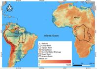
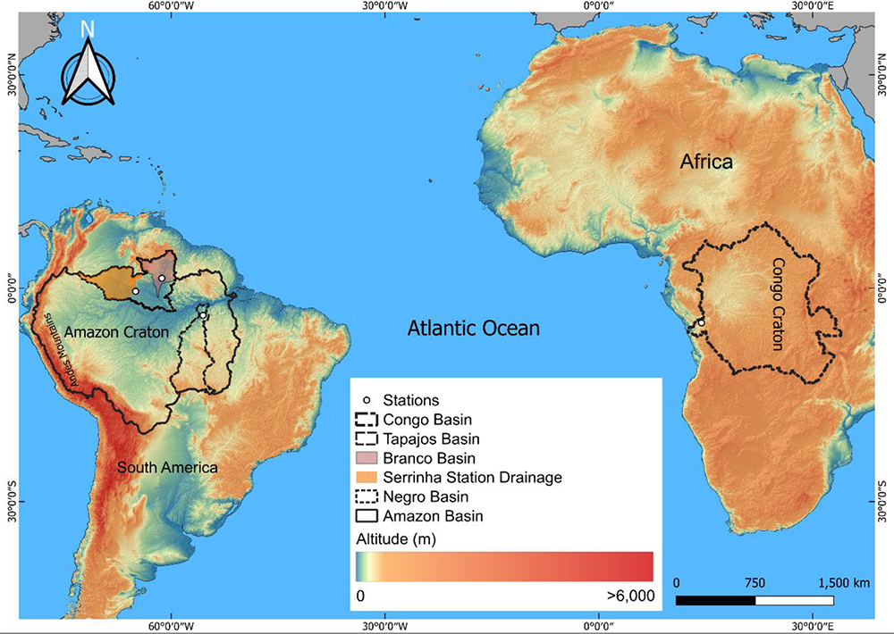
This article analyses the Negro, Branco and Tapajós Rivers basins, which are part of the Amazon basin, located in the Amazon Craton, and the Congo river basin, which drains the Congo Craton in Central Africa (Figure 1). The Negro River basin has an area of 700,000 km2 and its main channel has a water discharge of approximately 35,000 m3·s-1. The Negro River has a low suspended sediment concentration (SSC) (5.12 mg·L-1), suspended sediment discharge of 5.76×10⁶ ton·year-1 and sediment production of 8 ton·km-2·year-1 (Marinho et al., 2022). The Branco River basin has an area of approximately 197,000 km2 and its main channel flows into the Negro River, with a water discharge of 3,306 m3·s-1. The Negro and Branco Rivers basins drain the Guiana crystalline shield and sedimentary basins (Amazonas and Solimões) (Latrubesse; Stevaux, 2015).
The Tapajós River basin has an area of approximately 490,000 km2 and its main channel has a water discharge of ~13,000 m3·s-1. The Tapajós River has a suspended sediment discharge of approximately 6×10⁶ ton·year-1 and a sediment production of 12.2 ton·km-2·year-1 (Stevaux; Latrubesse, 2017). The basin drains the crystalline shield of Brazil and the lowlands of the Amazon basin (sedimentary basin) (Latrubesse et al., 2005).
The Congo River basin is the second largest in the world, behind the Amazon basin, with an area of 3,700,000 km2 and its main river is also the second largest in the world with a water discharge of approximately 41,000 m3·s-1. The Congo River has a suspended sediment discharge of 33.76×10⁶ ton·year-1 and a sediment production of 9.62 ton·km-2·year-1 (Queiroz; Marinho, 2024). The river, in its upper reaches, drains a Precambrian basement (Congo Shield) (Wit et al., 2015), in its centrals area (lowlands) it drains Cenozoic, Neogene and Quaternary sediments (Queiroz; Marinho, 2024).
SSC, Water Discharge and Rainfall data
The water discharge (Q) and SSC data were provided by the SO-HYBAM project (https://hybam.obs-mip.fr/), which is an observatory specializing in monitoring rivers and water resources. The observatory has been monitoring suspended SSC in Brazil since 1995 and in Africa since 2005. SO-HYBAM's SSC collection protocol is based on the recommendations of the UNEP GEMS/water Programme (Chapman, 1992), with surface collections every 10 days. For this work, the stations of Serrinha (Negro River), Caracaraí (Branco River), Itaituba (Tapajós River) and Brazzaville (Congo River) were used, totaling 1,323 samples (Table 1).
CHIRPS data (Climate Hazards Group InfraRed Precipitation with Station data) provides daily and monthly precipitation estimates on a global scale, with a spatial resolution of 0.05 degrees. This data is especially valuable for monitoring and understanding climate variability and precipitation patterns, especially in regions with a low density of conventional stations (Marinho; Rivera, 2021). CHIRPS combines satellite data, information from meteorological stations and climate models, allowing for continuous coverage since 1981 (Funk et al., 2015).
These data showed good results for quantifying rainfall in the Congo (Queiroz; Marinho, 2024) and Negro (Marinho; Rivera, 2021) rivers basins, despite underestimating the rainiest months (Cavalcanti et al., 2020). There is no validation with conventional rain gauge stations for CHIRPS data in the Tapajós River basin, but general data from the Amazon basin and studies located in the upper reaches of the basin indicate that the dataset is suitable for quantifying rainfall (Cavalcanti et al., 2020; Uliana et al., 2024).
Statistical Analyze
Statistical tests were applied to understand the relationship between SSC-rainfall and SSC-Water Discharge. For the calculations, the daily data were converted into monthly data to allow comparison between the different rivers analyzed. The coefficient of determination (R2) was used to calculate the proportion of the variation in the dependent variable that is explained by the independent variable; this coefficient varies from 0 to 1. Pearson's linear correlation (r) was used to identify linear relationships between hydro-sedimentological variables. However, considering that tropical rivers may exhibit delayed responses and nonlinear relationships (Filizola; Guyot, 2009), Kendall's correlation (τ) was also applied, based on the consistency of order between the data. This approach is more robust for detecting monotonic patterns, especially in the presence of hysteresis, time lag, and extreme values. These tests calculate the direction and strength of a relationship between two variables; the result can range from -1 (inversely proportional correlation) to 1 (directly proportional correlation).
In addition, the partial correlation of the data was calculated, which is a statistical measure that quantifies the relationship between two variables, eliminating the effect of one or more control variables (Equation 1). Unlike simple correlation, which measures the total association between two variables, partial correlation isolates the indirect influence mediated by a third variable, making it possible to analyze the direct relationship between the variables of interest.
rXY is the Pearson correlation between X and Y; rXZ is the correlation between X and Z; rYZ is the correlation between Y and Z; rXY⋅Z is the partial correlation between X and Y, controlling Z. To determine whether there is statistical significance between the r, Kendall, and partial correlation data, the t-test was calculated with a significance level of 0.05.
To analyze the dynamic relationship between suspended sediment concentration (SSC) and water discharge/rainfall, the hysteresis index proposed by Zuecco et al. (2016) was applied. The time series were organized into annual cycles and normalized to standardize the data and enable comparison between rivers with different regimes (Equation 2):
Where u(t) can represent SSC, water discharge, and normalized rainfall. The method divides the independent variable axis (Q or rainfall) into n equidistant intervals. For each interval, the areas under the rising (Ar[i,j]) and falling (Af[i,j]) branches of the SSC-Q (or SSC-rainfall) curve are calculated (Equation 3):
The mean hysteresis index is obtained from the average of the integral differences throughout the entire cycle.
RESULTS
Monthly and annual analysis of SSC, Water Discharge, and Rainfall
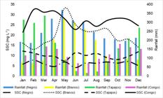
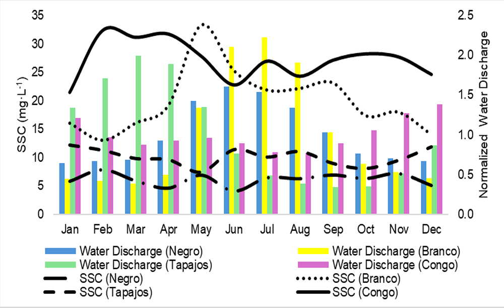
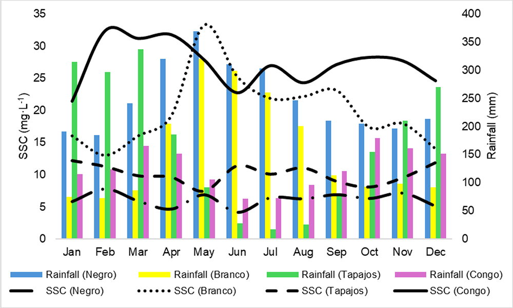
In the Serrinha station in the middle Negro River, the mean annual water discharge is 16,971 m3·s-1, with the highest values in June (27,243 m3·s-1) and the lowest in January (10,937 m3·s-1) (Figure 2). The low water period in the middle Negro River is from August to January, and the high-water period is between February and July. The mean annual SSC is 6.12 mg·L-1, with maximum concentrations in November (7.83 mg·L-1), the low water period, and minimum concentrations in June (4.13 mg·L-1), the high-water period. The annual rainfall for the area drained by the Serrinha station is 2.989 mm·year1, with monthly maximums in May (368.57 mm) and minimums in February (184.80 mm) (Figure 3).
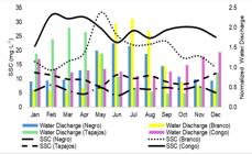
In the Branco River, the annual mean water discharge is 3,168 m3·s-1, with the highest values in July (7,056 m3·s-1) and the lowest in March (1,234 m3·s-1). The period of high water in the river is from April to August, and the period of low water is between September and March (Figure 2). The mean SSC of the Branco River at the Caracaraí station is 19.95 mg·L-1, around 226% higher than at Serrinha, characterizing the Branco River as the main tributary of the Negro River in the SSC. The highest concentrations occur in May (33.27 mg·L-1), the period of high water, and the lowest in February (13.05 mg·L-1), the period of low water. The annual rainfall for the Branco River basin is 1.914 mm·year-1, with the highest monthly values in May (319.77 mm) and the lowest in February (72.82 mm), the same months as the SSC's maximum and minimum values (Figure 3).
The mean annual water discharge of the Tapajós River is 11,387 m3·s-1, with the highest values in March (22,699 m3·s-1) and the lowest in September (3,935 m3·s-1). The high-water period runs from December to May and the low water period from June to November (Figure 2). In the Itaituba station, the river has a mean SSC of 10.11 mg·L-1, with maximum concentrations in January (12.15 mg·L-1) and minimum concentrations in May (7.47 mg·L-1), both during the high-water period. The annual rainfall of the Tapajós River basin is 2,010 mm·year-1, with maximum monthly values in March (337.31 mm) and minimum in July (16.65 mm) (Figure 3).
The mean annual water discharge of the Congo River at Brazzaville station is 41,268 m3·s-1, with the highest values in December (56,959 m3·s-1) and the lowest in August (31,827 m3·s-1). The period of high water in the basin runs from September to December, and the period of low water runs from January to August. However, unlike the other basins analyzed, the Congo River shows a rise in water level in May and a fall again in June (Figure 2). The mean annual SSC is 27.20 mg·L-1, with the highest concentrations in February (32.40 mg·L-1) and the lowest in January (21.44 mg·L-1), both during low water. Annual rainfall is 1.514 mm·year-1, with maximum monthly values in October (178.98 mm) and minimum in June (71.99 mm) (Figure 3).
Statistical analysis of the correlation between SSC and Water Discharge/Rainfall
The coefficients of determination between SSC and the variables of water discharge and rainfall for the Negro, Tapajós and Congo rivers were insignificant, indicating that the variance of the data of the dependent variable (SSC) is not explained by changes in the independent variable (water discharge and rainfall). For the Branco River, the R2 was moderate for rainfall and low for water discharge. It can be seen that the SSC of the Negro, Tapajós and Congo rivers does not show a clear annual pattern during the hydrological year, unlike the Branco River which shows a clear identifiable pattern throughout the hydrological year.
In terms of Pearson's linear correlation, the Tapajós showed an insignificant directly proportional correlation. In the Negro River, the correlation was inversely proportional and insignificant for water discharge and low for rainfall. On the Congo River, the correlation between SSC and water discharge was insignificant and inversely proportional, and with rainfall it was low and directly proportional. In the Branco River, the correlation with water discharge was moderate and with rainfall it was strong. The results for the Pearson and Kendall coefficients are not statistically significant at the 5% level (0.05), indicating that there is no clear statistical correlation between the data. The exception is the Branco River, which has a p-value of less than 0.05, showing that these variables are correlated. These data indicate that, except for the Branco River, none of the rivers analyzed present statistical data validating that SSC is controlled by water discharge or rainfall (Table 2).
The partial correlation for the Negro River is negative (-0.33) between SSC and rainfall when the effect of flow is isolated, suggesting that increased rainfall is associated with a slight reduction in SSC in this environment. When we isolate the effect of rainfall, the relationship between SSC and flow becomes insignificant (0.11), indicating that flow has no relevant influence on sediment transport in this system. The Tapajós River shows a low positive correlation (0.29) between SSC and rainfall, and no significant relationship with flow (-0.11).
The Branco River shows a markedly different pattern, with a strong positive correlation (0.73) between SSC and rainfall after controlling for flow. The absence of a significant relationship between SSC and flow when rainfall is isolated (-0.08) reinforces that rainfall is the dominant factor in the sediment dynamics of this river. The Congo River has complex dynamics: while rainfall shows a strong positive correlation (0.72) with SSC, flow shows an intense negative relationship (-0.64) when we isolate the effect of rainfall (Table 3), these results differ from the coefficient of determination, Pearson's linear correlation and Kendall's coefficient.
Analysis of hysteresis between SSC x Water Discharge/Rainfall in cratonic rivers
The integrated analysis between time lag (cross-correlation) and hysteresis index (HI) allowed us to analyze the nonlinear relationship between SSC and water discharge/rainfall. The results for the Negro River show a dampened and delayed behavior, with a lag of -3 months in relation to precipitation and -4 months in relation to water discharge. The negative and moderate HI value (h = -0.20) indicates counterclockwise hysteresis, reflecting a pattern of delayed SSC response, with a predominance of storage and dilution throughout the river regime. The Tapajós and Congo rivers did not show clear hysteresis, indicating an absence of control of both rainfall and water discharge. The Branco River showed the opposite behavior to the other rivers. The positive and moderate HI in the SSC×Q relationship characterizes clockwise hysteresis, indicating a system with direct hydrological control over SSC. The relationship between SSC and rainfall showed low counterclockwise hysteresis, suggesting some control of rainfall on SSC, but less than water discharge (Table 4).
DISCUSSION
Analysis of the relationship between SSC and Water Discharge/Rainfall
It was observed that in cratonic basins such as the Negro, Tapajós and Congo rivers there is no clear correlation between SSC x Rainfall and Water Discharge. Furthermore, it can be seen that in the Congo and Negro rivers there are inversely proportional correlations. These channels drain ancient Precambrian rocks that have been highly weathered, so neither rainfall nor water discharge has the capacity to erode these rocks enough to control the annual hydro-sedimentary dynamics of these rivers (Queiroz; Marinho, 2024). Although increased rainfall is directly related to increased soil erosion (García-Ruiz et al., 2015), the Negro River, which has the highest annual rainfall (2,989 mm·year-1), has the lowest mean SSC (6.12 mg·L-1) among the basins analyzed.
The results of the partial correlation analysis reveal important differences in the hydro-meteorological control over suspended sediment concentration (SSC) between the rivers analyzed. In the Branco River, a high partial correlation was observed between SSC and rainfall (r = 0.73), even with discharge control, which suggests a direct and significant control of precipitation over sediment production and transport. This behavior is in line with the younger and more unstable nature of the Branco basin, which has a greater slope, less developed soils and greater sensitivity to intense rainfall events. On the other hand, the correlation between SSC and discharge in this same river, controlling for rainfall, was practically zero (r = -0.08), reinforcing the dominant role of rainfall as an erosive agent and sediment mobilizer.
A different pattern can be observed in the Tapajós and Negro rivers. In the Tapajós, both the partial correlation between SSC and rainfall (r = 0.29) and between SSC and discharge (r = -0.11) were low and insignificant. In the Negro River, the results indicate a low negative correlation between SSC and rainfall (r = -0.33) and an insignificant one between SSC and discharge (r = 0.11). This indicates a system with low sensitivity to hydrological variations, possibly due to the geological stability, low slope and strong geomorphological and structural control of the basin (Queiroz et al., 2024a).
The case of the Congo River stands out for having a strong positive partial correlation between SSC and rainfall (r = 0.72), but a strong negative correlation between SSC and discharge (r = -0.64). This result may indicate that, although rainfall plays an important role in the mobilization of material, high flow volumes may be associated with the dilution of suspended sediment or the remobilization of finer sediments, which requires further investigation.
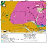
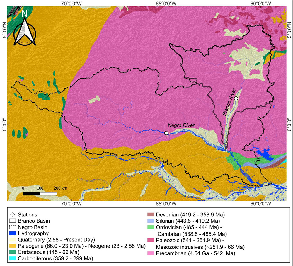
However, in rivers draining orogenic belts, there is a good correlation between these variables, with an R2 of 0.79 and an r of 0.89 between SSC and rainfall for the Madeira and Amazon rivers (Queiroz; Marinho, 2024). These rivers also carry a relatively higher SSC than the cratonic rivers. The Branco River also shows a good correlation of SSC with rainfall and water discharge, despite not draining the Andes like the Amazon and Madeira rivers. The difference between this basin and the Negro, Tapajós and Congo river basins, which drain ancient rocks in their upper reaches, is that the upper reaches of the Branco River drain an area of 29,000 km2 of Quaternary sediments (Figure 4). These more recent sediments are more favorable to weathering processes. Therefore, together with the slope, rainfall and water discharge have a greater capacity for erosion than in other cratonic basins.
According to Rivera et al., (2019) and Armijos et al., (2020) rainfall and water discharge in the Amazon basin can be used to directly estimate sediment discharge and the flow of fine suspended sediments. In addition, rainfall in Andean basins can increase the volume of groundwater, diluting the SSC (Rivera et al., 2019). In this work, we have not investigated the relationship between rainfall and groundwater dynamics and how it can influence the dilution of SSC in cratonic basins.
In cratonic basins such as the Negro, Tapajós and Congo basins, there are no clear correlations between rainfall-SSC and water discharge-SSC, making it impossible to estimate sediment discharge and fine suspended sediment flux using rainfall. However, in the Branco River basin, this relationship can be made since a strong relationship was observed between rainfall and SSC, due to the basin draining recent Quaternary sediments in its upper reaches. It should be noted that this study did not investigate the relationship between bed load (sand) and rainfall. Bed sediments are predominant in the Branco, Negro and Congo rivers (Stevaux; Latrubesse, 2017). It is therefore necessary to understand the relationship between bed sediments, rainfall and water discharge in these cratonic basins.
Analysis of Hysteresis in SSC Control by Water Discharge and Rainfall
The Branco River shows a clear pattern of hysteresis with moderate clockwise loop between SSC and water discharge, indicating that SSC dynamics are predominantly controlled by water discharge, with rapid sediment mobilization during river pulses. The low counterclockwise figure-eight hysteresis between SSC and rainfall indicates that the pattern is essentially a combination of clockwise and counterclockwise hysteresis cycles (Jing et al., 2025). The hysteresis data converge with the statistical analysis (r, Kendall, R2, and Partial Correlation), which points to a certain control of hydroclimatic variables in SSC.
However, analysis of the HI of the Negro River indicates counterclockwise hysteresis with control of water discharge in SSC, differing from direct statistical analysis. Some studies, such as Marinho et al., (2020) and Marinho et al. (2022), point out that there is an inversely proportional correlation between water discharge and SSC in the Negro River. This occurs due to the dilution of sediments that occurs during the high-water period, so the counterclockwise hysteresis observed may be the result of the dilution process and not directly from a control of discharge in the erosive processes of the Negro River. The Tapajós and Congo rivers do not show clear hysteresis loops in the SSC-water discharge-rainfall relationship, reinforcing the hypothesis that these variables do not control SSC in these rivers.
In addition, climate change tends to play a key role in increasing sediment transport (Li et al., 2024). In the Amazon basin, for instance, extreme hydrological events are becoming more frequent (Satyamurty et al., 2013; Maciel et al., 2022, 2024; Coulet et al., 2025; Queiroz et al., 2025), which may elevate suspended sediment concentrations (SSC) in the fluvial system. Queiroz et al., (2024b) reported increased SSC during extreme hydrological years in the Demini River basin, a tributary of the Negro River, although it is still uncertain whether this pattern is also reproduced in the main channel.
From a process-based perspective, increases in water discharge have also been linked to morphological channel adjustments (Leenman et al., 2025). Such dynamics are likely occurring in the Branco River, where SSC is at least partially controlled by discharge, as supported by both the positive lag between SSC and Q and the clockwise hysteresis pattern observed in the SSC-Q relation. This indicates that the sediment load responds rapidly to hydrological forcing and that high flows enhance sediment mobilization, pointing to a hydrologically reactive system.
In contrast, the Negro River exhibits moderate anti-clockwise hysteresis and high temporal lag, suggesting sediment storage, dilution, and delayed exportation along the hydrological cycle. Therefore, the relationship between discharge and SSC cannot be assumed as linear or instantaneous in low-energy blackwater systems. Under climate change projections, the interplay between hydrological extremes, hysteretic responses, and geomorphological feedbacks becomes increasingly relevant, particularly for assessing long-term sediment budgets and modeling future scenarios in the Amazon basin.
CONCLUSION
This work aimed to analyze whether the SSC is controlled by rainfall and water discharge in the Negro, Branco, Tapajós and Congo rivers. The results show that in large cratonic basins such as the Negro, Tapajós and Congo rivers, SSC is not significantly controlled by rainfall or water discharge, probably due to the ancient geological nature, Precambrian rocks that have been highly weathered over time, especially in the upper reaches of these basins.
It should be noted that, in the Congo River, the partial correlation between SSC and water discharge/rainfall showed moderate to high values, indicating that these parameters influence SSC, although not necessarily directly. On the other hand, the hysteresis analysis applied to the Negro River revealed a moderate HI in the SSC × water discharge relationship, evidencing a delayed and non-linear response of sediment transport in relation to the hydrological pulse, which may be directly linked to the dilution effect of the river.
The exception was the Branco River, which shows a significant correlation between SSC and rainfall and water discharge, which suggests that the lithology of the basin, specifically the presence of more recent Quaternary sediments, which are more erodible, may influence the response of SSC to hydrometeorological variables.
ACKNOWLEDGMENT
We would like to thank the Coordenação de Aperfeiçoamento de Pessoal de Nível Superior (CAPES) (Coordination for the Improvement of Higher Education Personnel) for granting us a Doctoral Scholarship and the anonymous reviewers who provided valuable suggestions to improve the manuscript.
Data availability
The data that support the findings of this study can be made available, upon reasonable request, from the corresponding author [Matheus Silveira de Queiroz].
REFERENCES
-
ACHITE, M.; OUILLON, S. Recent changes in climate, hydrology and sediment load in the Wadi Abd, Algeria (1970‐2010). Hydrology and Earth System Sciences, v. 20, n.4, p. 1355-1372, 2016. https://doi.org/10.5194/hess‐20‐1355‐2016
» https://doi.org/10.5194/hess‐20‐1355‐2016 -
ARMIJOS, E.; CRAVE, A. ; ESPINOZA, J.C. ; FILIZOLA, N. P.; ESPINOZA-VILLAR, R.; AYES, I.; FONSECA, P.; FRAIZY, P.; GUTIERREZ, O.; VAUCHEL, P.; CAMENEN, B.; MARTIINEZ, J.M.; SANTOS, A.; SANTINI, W.; COCHONNEAU, G.; GUYOT, J. L. Rainfall control on Amazon sediment flux: synthesis from 20 years of monitoring. Environmental Research Communications, v. 2, 2020. https://doi.org/10.1088/2515-7620/ab9003
» https://doi.org/10.1088/2515-7620/ab9003 -
BANDEIRA, I.C.N.; ADAMY, A.; ANDRETTA, E.R.; CONCEIÇÃO, R.A.C.; ANDRADE, M.M.N. Terras Caídas: Fluvial erosion or distinct phenomenon in the Amazon? Environmental Earth Sciences, v. 77, 2018. https://doi.org/10.1007/s12665-018-7405-7
» https://doi.org/10.1007/s12665-018-7405-7 -
CAVALCANTI, R. B. L.; FERRERIO, D. B. S.; PONTES, P. R. M.; TADESCHI, R. G.; COSTA, C. P. W.; SOUZA, E. B. Evaluation of extreme rainfall indices from CHIRPS precipitation estimates over the Brazilian Amazonia. Atmospheric Research, v. 28, n. 104879, 2020. https://doi.org/10.1016/j.atmosres.2020.104879
» https://doi.org/10.1016/j.atmosres.2020.104879 -
CHAPMAN, D. Water Quality Assessments-A Guide to Use of Biota, Sediments and Water in Environmental Monitoring. Second Edition. 1992, London, 651p. https://doi.org/10.4324/9780203476710
» https://doi.org/10.4324/9780203476710 -
COULET, P.; DURAND, F.; FASSONI-ANDRANDE, A.; KHAN, J.; TESTUT, L.; TOUBLANC, F.; SANTOS, L. G.; MOREIRA, D. M. Assessment of the hydrodynamical signature of the record-breaking 2021 flood along the Amazon estuary. Ocean Modelling, v. 196, p. 1-15, 2025. https://doi.org/10.1016/j.ocemod.2025.102536
» https://doi.org/10.1016/j.ocemod.2025.102536 -
FILIZOLA, N.; GUYOT, J. L. Suspended Sediment Yield in the Amazon Basin: an Assessment Using Brazilian National Data Set. Hydrological Processes, v. 23, n. 22, 32073215, 2009. https://doi.org/10.1002/hyp.7394
» https://doi.org/10.1002/hyp.7394 -
FUNK, C.; PETERSON, P.; LANDSFELD, M.; PEDREROS, D.; VERDIN, J.; SHUKLA, S.; HUSAK, G.; ROWLAND, J.; HARRISON, L.; HOELL, A.; MICHAELSEN, J. The climate hazards infrared precipitation with stations-a new environmental record for monitoring extremes. Scientific Data, v. 2, p. 150066, 2015. https://doi.org/10.1038/sdata.2015.66
» https://doi.org/10.1038/sdata.2015.66 -
GARCÍA-RUIZ, J.M.; BEGUERÍA, S.; NADAL-ROMERO, E.; GONZÁLEZ-HIDALGO, J. C.; LANA-RENAULT, N.; SANJUÁN, Y. A meta-analysis of soil erosion rates across the world. Geomorphology, v. 239, p. 160-173, 2015. https://doi.org/10.1016/j.geomorph.2015.03.008
» https://doi.org/10.1016/j.geomorph.2015.03.008 -
GHOSH, K.; MUNOZ‐ARRIOLA, F. Hysteresis and streamflow‐sediment relations across the pre‐to‐post dam construction continuum in a highly regulated transboundary Himalayan River basin. Journal of Hydrology, v. 624, n. 129885, 2023. https://doi.org/10.1016/j.jhydrol.2023.129885
» https://doi.org/10.1016/j.jhydrol.2023.129885 -
HADDADCHI, A.; HICKS, M. Interpreting event‐based suspended sediment concentration and flow hysteresis patterns. Journal of Soils and Sediments, v. 21, n. 1, p. 592-612, 2021. https://doi.org/10.1007/s11368‐020‐02777‐y
» https://doi.org/10.1007/s11368‐020‐02777‐y -
HARDING, R.; BEST, M.; BLYTH, E.; HAGEMANN, S.; KABAT, P.; TALLAKSEN, L.M.; WARNAARS, T.; WIBERG, D.; WEEDON, G.P.; VAN LANEN, H.; LUDWIG, F.; HADDELAND, I. WATCH: current knowledge of the terrestrial global water cycle. Journal of Hydrometeorology, v. 12, p. 1149-1156, 2011. https://doi.org/10.1175/JHM-D-11-024.1
» https://doi.org/10.1175/JHM-D-11-024.1 -
JING, T.; ZENG, Y.; FANG, N.; DAI, W.; SHI, Z. A Review of Suspended Sediment Hysteresis. Water Resources Research, v. 61, 2025. https://doi.org/10.1029/2024WR037216
» https://doi.org/10.1029/2024WR037216 -
LATRUBESSE, E.M.; STEVAUX, J.C.; SINHA, R. Tropical Rivers. Geomorphology, v. 70, p.187-206, 2005. https://doi.org/10.1016/j.geomorph.2005.02.005
» https://doi.org/10.1016/j.geomorph.2005.02.005 -
LATRUBESSE, E. M.; STEVAUX, J. C. The Anavilhanas and Mariuá Archipelagos: Fluvial Wonders from the Negro River, Amazon Basin. In: Vieira, B. C.; Salgado, A. A. R.; Santos, L.J.C. (Eds.), Landscapes and Landforms of Brazil, Springer, Dordrecht, p.157-169, 2015. https://doi.org/10.1007/978-94-017-8023-0_14
» https://doi.org/10.1007/978-94-017-8023-0_14 -
LEENMAN, A.; GREENBERG, E.; MOULDS, S.; WORTMANN, M.; SLATER, L.; GANTI, V. Accelerated River mobility linked to water discharge variability. Geophysical Research Letters, v. 52, 2025, https://doi.org/10.1029/2024GL112899
» https://doi.org/10.1029/2024GL112899 -
LI, L.; NI, J.; CHANG, F.; YUE, Y.; FROLOVA, N.; MAGRITSKY, D.; BORTHWICK, A.G.L.; CIAIS, P.; WANG, Y.; ZHENG, C.; WALLING, D.E. Global trends in water and sediment fluxes of the world’s large rivers. Science Bulletin, v. 65, p. 62-69, 2024. https://doi.org/10.1016/j.scib.2019.09.012
» https://doi.org/10.1016/j.scib.2019.09.012 -
LYU, Y.; FAGHERAZZI, S.; ZHENG, S.; TAN, G.; SHU, C. Enhanced hysteresis of suspended sediment transport in response to upstream damming: An example of the middle Yangtze River downstream of the Three Gorges Dam. Earth Surface Processes and Landforms, v. 45, n. 8, p. 1846-1859, 2020. https://doi.org/10.1002/esp.4850
» https://doi.org/10.1002/esp.4850 -
MACIEL, D.A.; LOUSADA, F.; FASSONI-ANDRADE, A.; QUEVEDO, R.P.; BARBOSA, C.F.; PAULE-BONNET, M.; NOVO, E.M.L.M. Sentinel-1 data reveals unprecedented reduction of open water extent due to 2023-2024 drought in the central Amazon basin. Environmental Research Letters, v. 19, 2024. https://doi.org/10.1088/1748-9326/ad8a71
» https://doi.org/10.1088/1748-9326/ad8a71 -
MACIEL, J.S.C.; ALVES, L.G.S.; OLIVEIRA, B.F.; SENNA, R.C.; ALBUQUERQUE, V.S. What Happened in 2021? Analyzing the Biggest Negro River Flood in Manaus, Brazil. WIT Transactions on The Built Environment v. 208, p. 3-14, 2022. https://doi.org/10.2495/FRIAR220011
» https://doi.org/10.2495/FRIAR220011 -
MARINHO, R.R.; FILIZOLA, N.P.; CREMON, É.H. Analysis of Suspended Sediment in the Anavilhanas Archipelago, Rio Negro, Amazon Basin. Water, v. 12, n. 1073, 2020. https://doi.org/10.3390/w12041073
» https://doi.org/10.3390/w12041073 -
MARINHO, R. R.; FILIZOLA, N. P.; MARTINEZ, J.M.; HARMEL, T. Suspended sediment transport estimation in Negro River (Amazon Basin) using MSI/Sentinel-2 data. Revista Brasileira de Geomorfologia, v. 23, 2022. https://doi.org/10.20502/rbg.v23i1.2076
» https://doi.org/10.20502/rbg.v23i1.2076 -
MARINHO, R. R.; RIVERA, I. A. A Precipitação Estimada por Satélite na Bacia do Rio Negro, Noroeste Amazônico (1981-2017). RAEGA - O Espaço Geográfico em Análise, v. 50, p. 44-61, 2021. https://doi.org/10.5380/raega.v50i0.67426
» https://doi.org/10.5380/raega.v50i0.67426 -
QUEIROZ, M. S.; MARINHO, R. R.; CARVALHO, J. A. L.; SILVA, C. F. The geomorphological landscape of the Mariuá Archipelago: An anabranching megacomplex system in the Negro River, Amazon Basin (Brazil). Geomorphology, v. 490, 2025. https://doi.org/10.1016/j.geomorph.2025.110023
» https://doi.org/10.1016/j.geomorph.2025.110023 -
QUEIROZ, M. S.; MARINHO, R. R.; ALVES, N. S.; RODRIGUES, C. Arquipélago de Anavilhanas: Uma revisão das suas formas, processos e origem. Revista Geonorte, v. 15, 2024a. https://doi.org/10.21170/geonorte.2024.V.15.N.48.166.198
» https://doi.org/10.21170/geonorte.2024.V.15.N.48.166.198 - QUEIROZ, M. S.; SOARES, A. P. A.; TOMAZ-NETO, A. G. Comunidades rurais ribeirinhas e as águas do rio Solimões no município de Iranduba - Amazonas. Revista Brasileira de Meio Ambiente, v. 4, p.108-119, 2018.
-
QUEIROZ, M. S.; MARINHO, R. R. Congo River: Analysis of Suspended Sediment Flux in a Multichannel Megasystem in Central Africa. RAEGA - O Espaço Geográfico em Análise , v. 61, p. 153-172, 2024. https://doi.org/10.5380/raega.v61i1.96047
» https://doi.org/10.5380/raega.v61i1.96047 -
QUEIROZ, M. S.; MARINHO, R. R.; SEVERO, E. B. Fluxo de Sedimento em Suspensão do Rio Demini, Noroeste Amazônico. Revista Contexto Geográfico v. 9, 2024b. https://doi.org/10.28998/contegeo.9i.20.17662
» https://doi.org/10.28998/contegeo.9i.20.17662 -
RIVERA, I.; CALLAU-PODUJE, A.C.; MOLINA-CARPIO, J.; AYALA, J.M.; ARMIJOS-CARDENAS, E.; ESPINOZA-VILLAR, R.; ESPINOZA, J.C.; GUTIERREZ-CORI, O.; FILIZOLA, N. On the Relationship between Suspended Sediment Concentration, Rainfall Variability and Groundwater: An Empirical and Probabilistic Analysis for the Andean Beni River, Bolivia (2003-2016). Water, v. 11, p. 2497, 2019. https://doi.org/10.3390/w11122497
» https://doi.org/10.3390/w11122497 -
SAFDAR, R.; TAHIR, S.; SHAHBAZ, M. Urbanization and suspended sediment transport dynamics: A comparative study of watersheds with different land uses. Water, v. 4, n. 1, p. 334-344, 2024. https://doi.org/10.1021/acsestwater.3c00328
» https://doi.org/10.1021/acsestwater.3c00328 -
SATYAMURTY, P.; COSTA, C. P. W.; MANZI, A. O.; CANDIDO, L. A. A quick look at the 2012 record flood in the Amazon Basin. Geophysical Research Letters , v. 40, p. 1396-1401, 2013. https://doi.org/10.1002/grl.50245
» https://doi.org/10.1002/grl.50245 -
SCHENK, C. J.; VIGER, R.; ANDERSON, C. P. South America Geologic Map (geo6ag). U.S. Geological Survey data release, 1999. https://doi.org/10.5066/P9A3OJ9B
» https://doi.org/10.5066/P9A3OJ9B - STEVAUX, J. C.; LATRUBESSE, E. Geomorfologia Fluvial. Oficina de Textos: São Paulo, 2017.
-
ULIANA, E. M.; SOUSA, M. F.; ARAUJO, J. A.; AIRES, U. R. V.; SILVA, D. D.; ZANUZO, M. R.; CRUZ, I. F. Validação e análise espaço-temporal de dados de precipitação obtidos por sensoriamento remoto CHIRPS para o estado de Mato Grosso, Brasil. Revista Brasileira de Climatologia, v. 35, n. 20, p. 630-654, 2024. https://doi.org/10.55761/abclima.v35i20.18858
» https://doi.org/10.55761/abclima.v35i20.18858 -
VERCRUYSSE, K.; GRABOWSKI, R. C.; RICKSON, R. J. Suspended sediment transport dynamics in rivers: Multi‐scale drivers of temporal variation. Earth‐Science Reviews, v. 166, p. 38-52, 2017. https://doi.org/10.1016/j.earscirev.2016.12.016
» https://doi.org/10.1016/j.earscirev.2016.12.016 -
WIT, M. J.; LINOL, B. Precambrian Basement of the Congo Basin and Its Flanking Terrains. In: Wit, M.; Guillocheau, F.; Wit, M. (Eds.). Geology and Resource Potential of the Congo Basin. Regional Geology Reviews, Springer, Berlin, Heidelberg, 2015. https://doi.org/10.1007/978-3-642-29482-2_2
» https://doi.org/10.1007/978-3-642-29482-2_2 -
WOHL, E. An integrative conceptualization of floodplain storage. Reviews of Geophysics, v. 59, n. 2, 2021. https://doi.org/10.1029/2020RG000724
» https://doi.org/10.1029/2020RG000724 -
ZUECCO, G.; PENNA D.; BORGA, M.; VAN-MEERVELD, H.J. A versatile index to characterize hysteresis between hydrological variables at the runoff event timescale. Hydrological Processes , v. 30, n. 9, p. 1449-1466, 2016. https://doi.org/10.1002/hyp.10681
» https://doi.org/10.1002/hyp.10681
-
ASSOCIATE EDITOR:
Silvio Carlos Rodrigues - 0000-0002-5376-1773

 Source: The author (2025).
 Source: The author (2025)
 Source: The author (2025).
 Source: