 Oceanographic features in the vicinity of Japaratuba Canyon, Sergipe, Brazil
ABSTRACT
This study presents an initial assessment of the hydrographic characteristics in the region of the Japaratuba Canyon on the continental shelf of Sergipe, Brazil. An oceanographic campaign was conducted, during which two high spatial resolution transects were made on the north and south sides of the canyon, along with a transverse transect. The results indicate that the hydrographic features are similar to those found on the continental shelf of Pernambuco, with the dominant water mass being Tropical Water. However, it differs in having a much greater influence from Coastal Water, as a result of the dispersion of the São Francisco River plume to the south and from small rivers that discharge into the northern portion of the continental shelf of the state of Sergipe. The near bottom turbidity and chlorophyll were relatively higher in the southern section, what can be an indication that the presence of the canyon can produce a localized upwelling effect, with the canyon playing a role in allowing the approach of water from the top of the nearest permanent thermocline to the coast.
Keywords:
Hydrography; Continental shelf; Upwelling
RESUMO
Este estudo apresenta uma avaliação inicial das características hidrográficas na região do Cânion do Rio Japaratuba, este cânion fica na plataforma continental de Sergipe, Brasil. Foi realizado uma campanha oceanográfica, durante a campanha oceanográfica foram realizados dois transectos de alta resolução espacial nos lados norte e sul do cânion, juntamente com um transecto transversal. Os resultados indicam que as características hidrográficas são semelhantes às encontradas na plataforma continental de Pernambuco, com a massa de água dominante sendo a Água Tropical. No entanto, difere por ter apresentado uma influência maior da Água Costeira, resultado da dispersão da pluma do Rio São Francisco e de pequenos Rios que desaguam na porção norte da plataforma continental do estado de Sergipe, em direção sul. A turbidez e a clorofila próximo ao fundo, foram relativamente mais altas na seção sul, o que pode ser uma indicação de que a presença do cânion pode produzir um efeito de ressurgência localizado, desempenhando um papel no soerguimento da água do topo da termoclina permanente, para uma região mais próxima da costa.
Palavras-chave:
Hidrografia; Plataforma continental; Ressurgência
INTRODUCTION
The continental shelf along Brazil exhibits varying width, ranging from narrow stretches of a few kilometers, such as in the state of Bahia, to relatively wide expanses of up to hundreds of kilometers, as seen in the state of Amazonas, with an average slope of 1:1000. The shelf break depth varies between 40 and 60 meters in the northeast region and 150 to 200 meters in the southern region (Schmiegelow, 2004). It covers an area of 5 x 10⁶ km2 and is tectonically stable, experiencing no significant movements or volcanic activity (Fontes et al., 2017; Coutinho, 1996).
Off the coast of the State of Sergipe (PCS), the shelf has an average width of 33 kilometers (Fontes et al., 2017) and features two submarine canyons: the São Francisco Canyon to the north, on the border with the state of Alagoas, and the Japaratuba Canyon in the central region (Figure 1). The Japaratuba Canyon was initially described by Summerhayes et al. (1976) and Fontes et al. (2017), and it stands out geologically, with the presence of muddy deposits and their association with shrimp fishing using trawl nets. The narrowest points on the state’s continental shelf are found at the beginning of these two emerged canyons, where the shelf has a width of 9 and 11.5 kilometers, respectively (Carneiro & Arguelho, 2018).

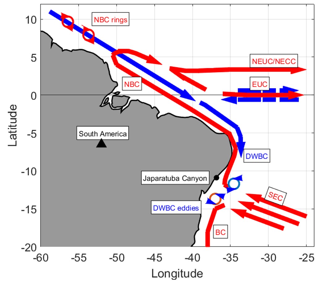
Circulation at the western edge of the tropical Atlantic (modified from Dengler et al., 2004). The red lines represent surface currents, and the blue lines represent subsurface currents. The highlighted currents indicate the South Equatorial Current (SEC), the North Brazil Undercurrent (NBU), the North Brazil Current (NBC), the Equatorial Undercurrent (EUC), Brazil Current (BC), the North Equatorial Counter Current (NECC), and the Deep Western Boundary Current (DWBC).
Given the relatively narrow nature of the continental shelf, its hydrodynamics and water properties are influenced by interactions with mesoscale oceanic processes (Schettini et al., 2017). The circulation of the western Atlantic Ocean is schematically represented in Figure 1. According to Stramma & Peterson (1990), the bifurcation of the South Equatorial Current (SEC) occurs between latitudes 11 and 15° south, forming the Brazil Current, which flows southward along most of the Brazilian coast, and the central branch of the SEC forming the North Brazil Current (Schott et al., 2005; Luko et al., 2021). This places the continental shelf of Sergipe in the area of influence of the southern branch of the South Equatorial Current, resulting in the presence of warm and more saline waters.
The interactions between meso-scale currents on the continental slope with geomorphologic features such as a submarine canyon crossing the shallower continental shelf can result in complex hydrodynamic patterns. One is the generation Lee Waves, which can potentially result in upwelling on downstream of the canyon (Kampf, 2012). The main goal of this article it to report the results of a field experiment designed to assess the effect of the presence of a submarine canyon, the Japaratuba Canyon, on the shelf water properties.
STUDY AREA
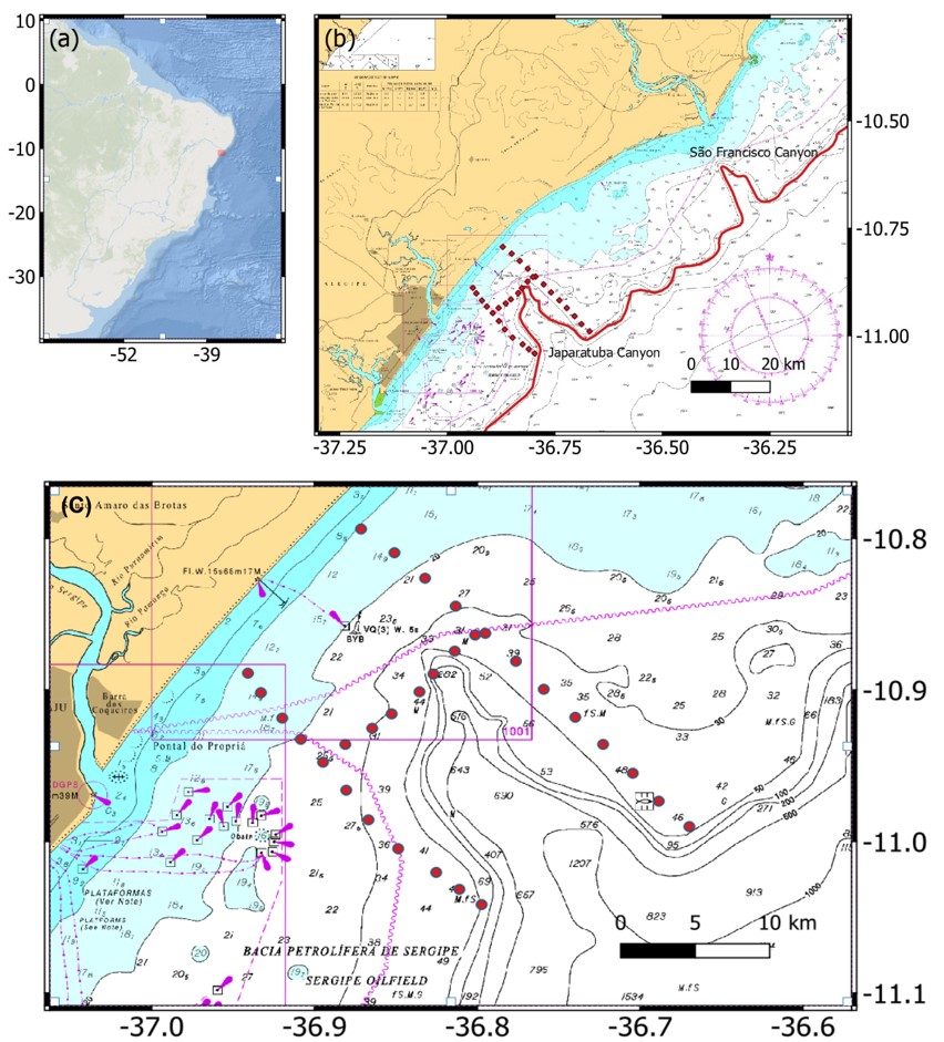
The Japaratuba Canyon is located in the central region of the Sergipe Continental Shelf (PCS), in front of the city of Pirambu in the state of Sergipe. It stretches approximately 18 kilometers (Figure 2) with a slope gradient of 75:1000 over a distance of 9.6 kilometers in the southeast direction at 145°. The depth at the center of the canyon is 725 meters (Nautical chart DHN 1001).
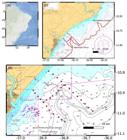
(a) Location of the study area in the context of South America, (b) excerpt from the nautical chart No. 22300 of the Brazilian Navy showing the northern platform of Sergipe and indicating the 200 m bathymetric line, and (c) a detailed view of the Japaratuba Canyon with the location of sampling stations.
The state of Sergipe has a population of 2.2 x 10⁶ people (IBGE). The climate is tropical, and the average precipitation in the capital, Aracaju, located on the coastline, was 1013 mm between September 2022 and May 2023. The average temperature was 26.6°C, with an average wind speed of 5.86 m/s and a mean wind direction of 108.6° (INMET). The wettest and driest months in Aracaju are May and November, respectively (Carneiro & Arguelho, 2018). The tides are semi-diurnal, can vary from 0.5 to 2.4 meters under spring and neap tide conditions.
The hydrographic characteristics of the continental shelf off the coasts of Alagoas and Sergipe were previously described by Parente et al. (2021). The temperature ranges between 25.4 and 28.4°C in May, and between 24.4 and 26.6°C in November. Salinity values range from 35.4 to 37.3 g/kg in May and from 28.9 to 37.2 g/kg in November. Currents in continental shelf are primarily determined by the wind regime, which on the Brazil northeast region the winds predominantly comes more weak from the northeast and east in the summer and strong comes from the south and southeast in the winter, resulting in shelf currents flowing southward in the winter and northeward in the summer, with intensities reaching up to 0.85 m/s. Similar patterns have been reported by Domingues et al. (2017) and Schettini et al. (2017) for the austral summer on the continental shelf of the state of Pernambuco.
The circulation in the area of the Japaratuba Canyon was investigated by Giovannino et al. (2019) using numerical modeling. This study indicated that currents in the canyon flow towards the continent when the winds come from the north or northeast, suggesting the possibility of upwelling of deep water from the top of the thermocline. There are no direct observations of currents, but artisanal fishermen report that during certain periods of the year, surface nets are carried towards the ocean in the coastal region of the canyon, suggesting complex patterns of hydrodynamic interaction.
MATERIAL AND METHODS
Hydrographic data were collected during an oceanographic expedition to investigate the Japaratuba Canyon region (Figure 1). The route taken aimed to collect data around the canyon both to the north and to the south, as well as along the inner boundary. The oceanographic campaign took place on May 27, 2023, during which vertical CTD profiles were recorded at 31 stations. The depth of the coastal profiles was 12 meters, reaching up to 75 meters in the central part of the canyon. The total campaign route covered 108 kilometers of navigation, and the results were analyzed using three transects: northern (TN), southern (TS), and central (TC). The sampling points were approximately 2.8 kilometers apart.
A JFE-Advantech CTD (Conductivity Temperature and Depth) profiler, model Rinko-Profiler, was used for data collection. It had a data acquisition rate of 10 Hz, with a temperature resolution of 0.001°C and a conductivity resolution of 0.001 ms/cm. This CTD also recorded data on chlorophyll, turbidity, and dissolved oxygen. The data underwent consistency analysis to eliminate spurious data and were analyzed based on property distributions in the sections and temperature-salinity (TS) diagrams. Data processing was carried out using Python via Jupyter Notebooks. The CTD data were processed to consider only the downcast profile, and the near surface (0.5 m) and near bottom (0.5 m) data were discarded. The chlorophyll data from the CTD is derived from fluorescence probe, which is a surrogate for this variable (Silva & Garcia, 2021). The turbidity is derived from an optical backscatter probe, which has proven reliable as surrogate of suspended particulate matter in coastal waters (Boss et al., 2009).
Additional wind data were obtained from the ERA5 hourly dataset (Hersbach et al., 2018). Data for the surrounding area of the study were used, with longitude boundaries of -37.5 and -35.5 West and latitude boundaries of -12.0 and -10.0 South for the month of May 2023 to characterize the wind field during the cruise. For climatology, a time series from 2010 to the present was used for the coordinate point with longitude -36.75 and latitude -11.
Ekman transport (Pond & Pickard, 1983) for the cartesian meridional and zonal components and were calculated based on the wind data from the ERA5, by
where and are the meridional and zonal wind shear stress, given by
where is the air density (~ 1.15 kg/m3 at 28 °C and 1015 hPa), is a non-dimensional drag coefficient (1.4 x 10⁻³), is the wind magnitude (m/s), and and are the meridional and zonal wind components (m/s). is the Coriolis parameter (), being the Earth´s angular velocity (7.3 x 10⁻⁵ rad/s) and the latitude (11° south). is the water density (1025 kg/m3). is the Ekman Layer, or the water depth influenced by the wind, given by
where is the vertical eddy coefficient. We used an = 0.01 m/s2.
RESULTS
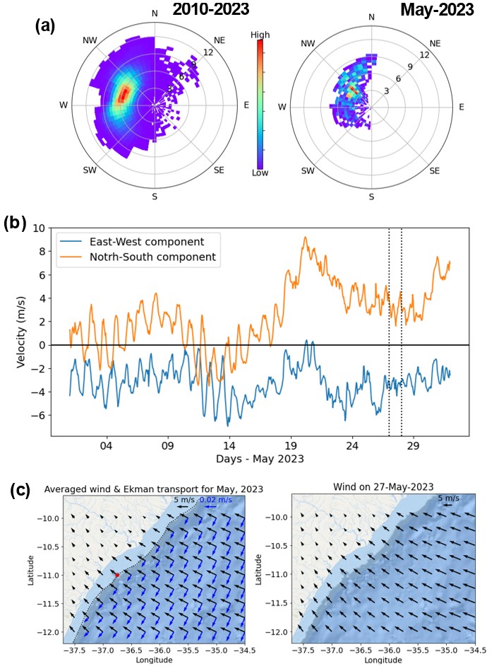
Figure 3a presents the climatological wind pattern and the wind pattern during May 2023. Given that the wind regime in the tropical South Atlantic is dominated by the semi-permanent pressure center, the region is locally dominated by easterly winds throughout the year, with greater variability in the north-south component. Conditions for May 2023 reflect this overall pattern, with the east-west component of the wind always being negative (westward), while the north-south component showed more variability and reversed direction (Figure 3b). Considering the regional physiographic situation, the wind acts almost perpendicular to the coastline (Figure 3c).
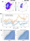
(a) Polar frequency distributions of wind climatology (2010-2023) and for May 2023; (b) Time series of the east-west and north-south wind components for the study area (red dot in (c)); Regional distribution of wind direction and intensity for the average wind (black arrows) Ekman Transport (blue arrows) in May, 2023, and wind for May 27, 2023.
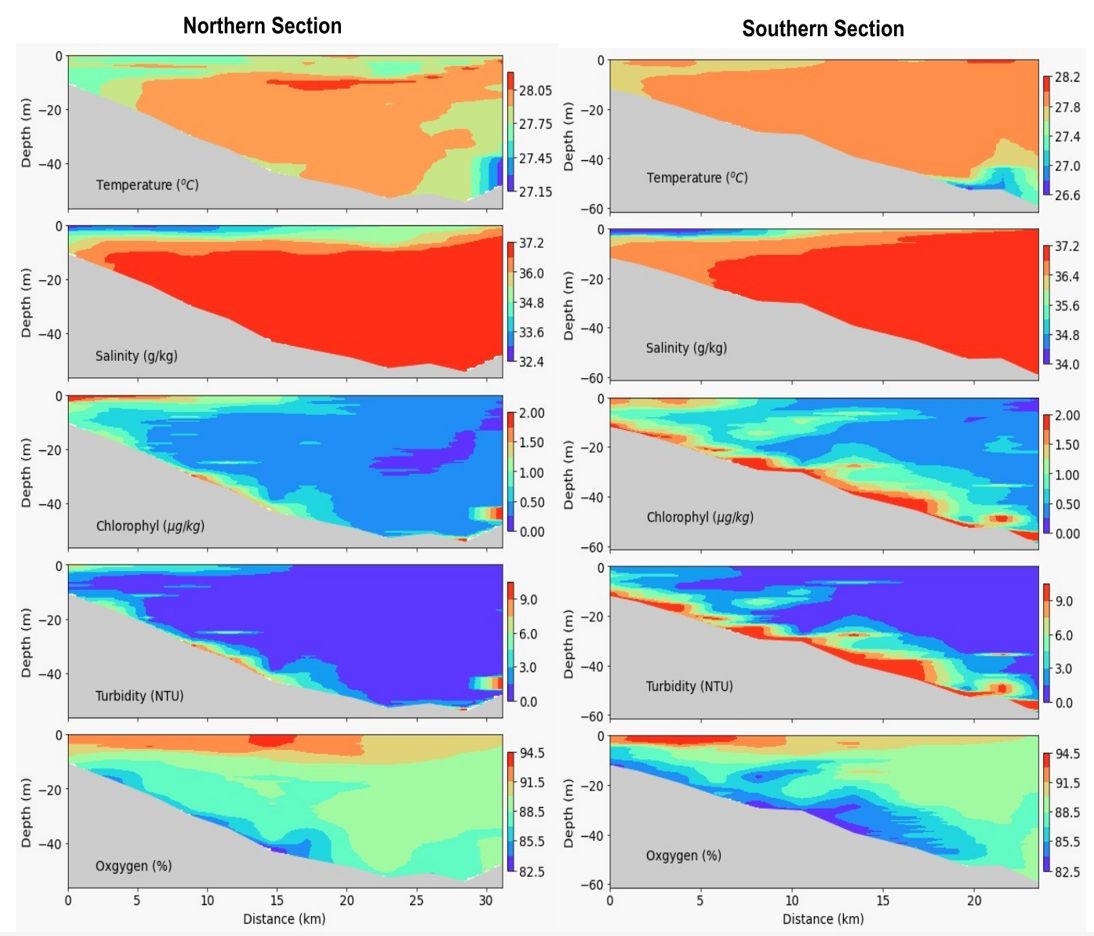
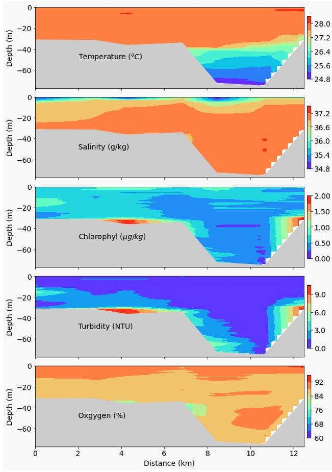
Figure 4 depict the distributions of temperature, salinity, chlorophyll, turbidity, and dissolved oxygen in the sections located to the north and south of the canyon, extending to the shelf break. The northern section covers 31 kilometers with 12 stations, while the southern section covers 24 kilometers with 11 stations. The temperature distribution showed a small range of variation, about 1°C in the northern section (27.1 to 28.1°C), and slightly larger in the southern section, about 1.5°C (26.6 to 28.2°C; figure 6). In both sections, the lowest temperatures were observed on the outer part of the shelf in the deeper regions. Salinity in both sections was predominantly high, with a value of approximately 37.2 g/kg (Tropical Water, TW), with a well-defined shallow layer (approximately 10 meters) of Coastal Water (CW) with minimum salinity values of 34 g/kg at the surface, extending up to about 7 kilometers. In the northern section, the CW layer extends to nearly the outer portion of the section, while in the southern section, it is more restricted to the central part.
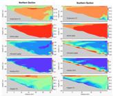
Distributions of temperature, salinity, chlorophyll, turbidity, and dissolved oxygen in the northern and southern sections of the canyon.
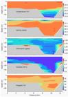
Distributions of temperature, salinity, chlorophyll, turbidity, and dissolved oxygen in the central section of the canyon.
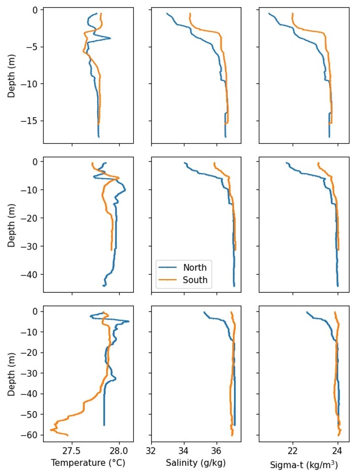
Figure 5 presents vertical profiles of salinity, temperature, and density anomaly for positions near the coast, mid-shelf, and the shelf break regions of the northern and southern sections. The presence of CW is more pronounced in all profiles of the northern section, while it appears more visibly in the coastal and mid-shelf stations of the southern section. Temperature exhibits complex patterns near the surface in both sections, but the most notable feature is the more pronounced decrease in temperature in the southern section near the shelf break.
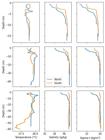
Vertical profiles of temperature (left), salinity (middle) and density anomaly (right) in the inner (top), middle (middle) and outer (bottom) shelf at the north (blue) and south (orange) sections.
Chlorophyll values reached 3 µg/kg, which can be considered relatively high for regions dominated by oligotrophic water masses. In both sections (Figure 4), the spatial distribution of chlorophyll showed higher values in the surface layer and closer to the coast, associated with lower salinity waters likely associated with the plume of São Francisco River. It is also noticeable higher near bottom chlorophyll and turbidity in the southern section when compared with the northern one. Dissolved oxygen distributions in both sections showed saturated conditions (>80%) with vertical gradients. There seems to be a relationship between higher oxygen saturation in the surface layer related to the CW. The lowest oxygen saturation values in both sections were associated with regions of higher chlorophyll and turbidity values near the seabed.
Figure 6 shows the water property distributions across the central section, approximately 12 kilometers from the coast. The northern part of this section covered the innermost part of the canyon, with depths ranging from 30 to 70 meters. It is in this region that the lowest temperatures (around 24°C) and more pronounced stratification from 40 meters were recorded.
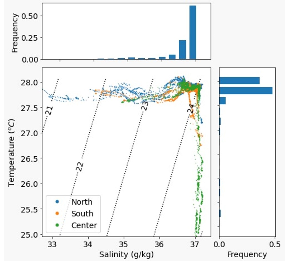
Figure 7 presents the TS (temperature-salinity) diagram for the data from the three sections. The temperature data shows a mode between 27.8 and 28°C, and the salinity mode is 37 g/kg, indicating the dominance of Tropical Water (TW). Coastal Water (CW) occurs as a result of the dilution of TW by freshwater input. Also, the presence of salty and colder waters occurs, indicating the presence of waters from the top of the permanent thermocline, which already characterizes the South Atlantic Central Water (SACW).
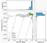
Temperature-salinity diagram indicating the observations in north (blue), south (orange) and central (green) sections. The frequency of salinity and temperature are in blue colorbar graphycs, salinity on the top and temperature in the left.
DISCUSSION
Wind is the primary agent responsible for subtidal circulation in most continental shelves, mainly for the along shore component (Mooers, 1976; Bowden, 1983; Simpson & Sharples, 2012), and in the present case, it applies to regional comparison through direct observations made on the Pernambuco and Bahia continental shelves to the north and south, respectively (Domingues et al., 2017; Schettini et al., 2017; Thévenin et al., 2019). According Parente 2021, the wind in the Sergipe-Alagoas Continental Shelf, present a preferential direction from east and east-southeast, where wind was the primary driver of the subtidal circulation in the region, their results showed a correlation of 0.75 between wind and currents on the continental shelf. In deeper regions, this wind pattern will, with winds coming from the east, induce southward transport through the Ekman mechanism, which in the Southern Hemisphere can rotate up to 90° to the left . This assumption is supported by observations of water properties, especially for the presence of diluted CW on the top layer which is most likely caused by the São Francisco freshwater flow and other small rivers of the region.
Considering (1) the extent of the CW occurrence, (2) the gradient across the sections at the surface, and (3) the wind condition, the CW is directly related to the southward dispersion of the São Francisco River freshwater plume (Paiva & Schettini, 2021). The mean flow of the current on the Sergipe –Alagoas continental shelf is to the southward, parallel to the coast (Parente et al., 2021). On the Pernambuco shelf, there is a dominance of TW with temperature values above 26°C and salinity above 36 g/kg in both winter and summer (Domingues et al., 2017; Schettini et al., 2017), which are very similar to the observations below the CW in the Sergipe shelf. This, along with the presence of the São Francisco River’s CW plume, reinforce the hypothesis of a southward current pattern.
The relatively higher chlorophyll and turbidity values along the bottom layer of the transect to the south of the canyon (Figure 4) suggests a differential hydrodynamic regime compared with the transect to the north of the canyon. The presence of the canyon appear to play a role in facilitating the penetration of deeper and nutrient-rich waters closer to the coast, acting as a channel and possibly a ramp. This is particularly relevant since the sections are only 10 km apart each other and were sampled in matters of hours, so the results give a nearly synoptic snapshot of the variables distributions. It is possible that in some seasons of the year with favorable conditions, the uplift of deeper water masses along the canyon culminates in the upwelling of upper layer of the permanent thermocline (South Atlantic Central Water, SACW), which is richer in nutrients than the TW, and when brought to the surface of the continental shelf, could play a role in primary productivity (Regaudie-De-Gioux et al., 2017).
Along the entire southern section, elevated chlorophyll and turbidity values near the seabed are also observed, which is not the case in the northern section. This differential pattern suggest that there is an also differential hydrodynamic regime between both sides of the canyon. Considering the southward current, the increase in chlorophyll and turbidity to the south suggeststhe occurrence of upwelling induced by the presence of the canyon (Kampf, 2012). Turbidity distributions show patterns very similar to chlorophyll, suggesting that the particles causing turbidity are phytoplankton themselves.
The lowest salinity values in the surface layer near the coast, extending about 10 km along the transects, are also associated with higher chlorophyll values. This association is explained by the input of nutrients from continental sources and their conversion into primary production (e.g., Lohrenz et al., 1999; Schettini et al., 2011). The extent of the CW offshore suggests a significant input of freshwater, and it certainly indicates the input of freshwater and nutrients from the São Francisco River (Medeiros et al., 2011).
CONCLUSIONS
This study presents a high-resolution assessment on the thermohaline characteristics of continental shelf in the vicinity of the Japaratuba Canyon. The water masses were dominated by the presence of Tropical Water (TW), however with is a greater presence of Coastal Water (CW) due to the dispersion of the São Francisco River plume to the south. At the deeper regions the water temperature decreased, indicating the presence of South Atlantic Central Water (SACW). The latter is directly associated with deeper areas of the canyon.
Higher values of chlorophyll and turbidity were recorded at the southern side of the canyon, as well smaller values bottom temperature at the outer shelf. This pattern suggests some sort of interaction between currents and the seafloor, likely due to the upwelling of deeper water masses. The presence of the São Francisco river plume also was related with higher values of chlorophyll.
ACKNOWLEDGEMENTS
The authors would like to thank the crew of the research vessel for their support during field activities. Additionally, we extend our appreciation to the Brazilian National Science Council (CNPq, #316037/2021-4).
REFERENCES
-
Boss, E., Taylor, L., Gilbert, S., Gundersen, K., Hawley, N., Janzen, C., Johengen, T., Purcell, H., Robertson, C., Schar, D. W. H., Smith, G. J., & Tamburri, M. N. (2009). Comparison of inherent optical properties as a surrogate for particular matter concentration in coastal waters. Limnology and Oceanography, Methods, http://dx.doi.org/10.4319/lom.2009.7.803
» http://dx.doi.org/10.4319/lom.2009.7.803 - Bowden, K. F. (1983). Physical oceanography of coastal waters New York: Ellis Horwood.
- Carneiro, M. E. R., & Arguelho, M. L. P. M. (2018). Plataforma continental de Sergipe e alagoas: geoquímica Seddimentar e Comunidade Bêntica São Cristóvão: Editora UFS.
- Coutinho, P. N. (1996). Recursos vivos marinhos do Brasil. Brasília, DF: Ministério do Meio Ambiente, dos Recursos Renováveis e da Amazônia Legal. (Programa REVIZEE).
- Domingues, E. C., Schettini, C. A. F., Truccolo, E. C., & Oliveira, J. C. O. (2017). Hydrography and current on the Pernambuco Continental Shelf. Brazilian Journal of Water Resources, 22, e43.
- Dengler, M., Schott, F. A., Eden, C., Brandt, P., Fischer, J., & Zantopp, R. J. (2004). Break-up of the Atlantic deep western boundary current into eddies at 8 degrees S. Nature, 432, 1018-1020.
- Fontes, L. C. S., Kowsmann, R. O., & Bernabéu, A. P. (2017). Geologia e geomorfologia da bacia de Sergipe-Alagoas São Cristóvão: Editora UFS.
- Giovannino, S. R. D., Dottori, M., & Martins, R. P. (2019). The northe Brazil Undercurrent and te wind driven hydrodynamics in Japaratuba Submarine canyon, Brazil. Brazilian Journal of Oceanography, 67, e19221.
- Hersbach, H., Bell, B., Berrisford, P., Biavati, G., Horányi, A., Muñoz Sabater, J., Nicolas, J., Peubey, C., Radu, R., Rozum, I., Schepers, D., Simmons, A., Soci, C., Dee, D., & Thépaut, J.-N. (2018). ERA5 hourly data on single levels from 1940 to present. Copernicus Climate Change Service (C3S). Climate Data Store, 10, 1024381. http://dx.doi.org/10.24381/cds.adbb2d47.
- Kampf, J. (2012). Lee effects of localized upwelling in a shelf-break canyon. Continental Shelf Research, 42(1), 78-88.
- Lohrenz, S. E., Fahnenstiel, G. L., Redalje, D. G., Lang, G. A., Dagg, M. J., Whiteledge, T. E., & Dortch, Q. (1999). Nutrients, irradiance, and mixing as factors regulating primary production in coastal waters impacted by the Mississippi River plume. Continental Shelf Research, 19(9), 1113-1141.
- Luko, C. D., Silveira, I. C. A., Simões-Sousa, L. T., Araújo, J. M., & Tandon, A. (2021). Revisiting the Atantic South Equatorial Current. Journal of Geophysical Research. Oceans, 124(7)
-
Medeiros, P. R. P., Knoppers, B. A., Cavalcante, G. H., & De Souza, W. F. L. (2011). Changes in nutrient loads (N, P and Si) in the São Francisco estuary after the construction of dams. Brazilian Archives of Biology and Technology, 54, 387-397. http://dx.doi.org/10.1590/S1516-89132011000200022
» http://dx.doi.org/10.1590/S1516-89132011000200022 - Mooers, C. N. K. (1976). Introduction to the physical oceanography and fluid dynamics of continental margins. In D. J. Stanley & D. J. P. Swift (Eds.), Marine sediment transport and environmental management (pp. 7-21). New York, John Wiley and Sons.
- Paiva, B. P., & Schettini, C. A. F. (2021). Circulation and transport processes in a tidally forced salt-wedge estuary: the São Francisco river estuary, Northeast Brazil. Regional Studies in Marine Science, 41, 101602.
- Parente, F. T. F., Dottori, M., Martins, R. P., Castro, B. M. F., & Sasaki, D. K. (2021). Wind stress forcing in a narrow tropical western boundary continental shelf: northeastern Brazil. Regional Studies in Marine Science, 48, 102028.
- Pond, S., & Pickard, G. L. (1983). Introductory Dynamical Oceanography (2nd ed.). New York: Elsevier.
- Regaudie-De-Gioux, A., Castagna, A., Ferreira, A., Abbrecht, M., Braga, E. S., & Ciotti, A. M. (2017). Influence of mixed upwelled Waters on metabolic balance in a subtropical coastal ecosystem: São Sebastião Channel, southern Brazi. Marine Ecology Progress Series, 573, 61-72.
- Schettini, C. A. F., Domingues, E. C., Truccolo, E. C., Oliveira Filho, J. C., & Mazzini, P. L. F. (2017). Seasonal variability of water masses and currents at the eastern Brazilian continental shelf (7.5 – 9°). Regional Studies in Marine Science, 16, 131-144.
- Schettini, C. A. F., Parente, L. M., & Truccolo, E. C. (2011). Analysis of sea level variability on the costal zone of Fortaleza, Ceará State. Labomar Arquivos de Ciências do Mar, 44(1), 27-32.
- Schmiegelow, J. M. M. (2004). O planeta azul: uma introdução às ciências marinhas Rio de Janeiro: Editora Interferência.
- Schott, F. A., Dengler, M., Zantopp, R., Stramma, L., Fischer, J., & Brandt, P. (2005). The shallow and deep western boundary circulation of the South Atlantic at 5°– 11°S. Journal of Physical Oceanography, 35, 2031-2053.
- Silva, G. S. D. M., & Garcia, C. A. E. (2021). Evaluation of ocean chlorophyll-a remote sensing algorithms using in situ fluorescence data in Southern Brazilian Coastal Waters. Ocean and Coastal Research, 69, e21012.
- Simpson, J. H., & Sharples, J. (2012). Introduction to the physical and biological oceanography of shelf seas. Cambridge: Cambridge University Press.
- Stramma, L., & Peterson, R. G. (1990). The South Atlantic Current. Journal of Physical Oceanography, 20, 846-859.
- Summerhayes, C. P., Fainstein, R., & Ellis, J. P. (1976). Continental margin off Sergipe and Alagoas, Northeastern Brazil: a reconnaissance Geophysical Study of Morphology and Structure. Marine Geology, 20, 345-361.
- Thévenin, M. R., Pereira, J., & Lessa, G. C. (2019). Shelf-break upwelling on a very narrow continental shelf adjacent to a western boundary current formation zone. Journal of Marine Systems, 194, 52-65.
Edited by
-
Editor-in-Chief: Adilson PinheiroAssociated Editor: Iran Eduardo Lima Neto