 850 hPa Geopotential Height Link with Iraqi Precipitation and Temperature
Abstract
The study examines the connection between the geopotential height (Z850 hPa) and the temperature (°C) and precipitation (mm) in Iraq. The observation data for climatological parameters that are currently available from the Iraqi meteorological organization are used. The temporal analysis of precipitation had a homogeneous data with a single mean for the period but temperatures throughout the research period exhibit a fluctuating tendency, with most stations showing a rising trend after 1993. The northern mountain area of Iraq has the highest amounts of precipitation, while the southern portion of the country records the lowest amounts. The distribution of temperature is characterized in reverse by the precipitation pattern. A correlation map is used for investigating the link between Z850 hPa and the two Iraqi climatological factors. According to the research, cold air descending from the Polar Regions is the primary mechanism responsible for bringing cold air mass over the Iraqi region during winter precipitation. Iraq receives precipitation in the springtime mostly due to the advection of moist air from the Mediterranean Sea and North Africa. Additionally, during summer and autumn, the hot air advection from India and eastern Africa through the Arabian Peninsula is associated with Iraqi temperature patterns.
Keywards
homogeneity; climate variability; ENSO; correlation map
Resumo
O estudo examina a conexão entre a altura geopotencial (Z850 hPa) e a temperatura (°C) e precipitação (mm) no Iraque. São utilizados os dados de observação dos parâmetros climatológicos atualmente disponíveis na organização meteorológica iraquiana. A análise temporal da precipitação apresentou dados homogêneos com uma única média para o período, mas as temperaturas ao longo do período de pesquisa apresentam uma tendência flutuante, com a maioria das estações mostrando uma tendência crescente após 1993. A área montanhosa do norte do Iraque tem as maiores quantidades de precipitação, enquanto a porção sul do país regista os valores mais baixos. A distribuição de temperatura apresentou padrão de precipitação inverso. Um mapa de correlação foi usado para investigar a ligação entre Z850 hPa e fatores climatológicos iraquianos. O ar frio que desce das regiões polares é o principal mecanismo responsável por trazer massa de ar frio sobre a região iraquiana durante as precipitações de inverno. O Iraque recebe precipitação na primavera devido à advecção de ar úmido do Mar Mediterrâneo e do Norte da áfrica. Além disso, durante o verão e o outono, a advecção de ar quente da índia e da áfrica Oriental através da Península Arábica está associada aos padrões de temperatura do Iraque.
Palavras-chave
homogeneidade; variabilidade climática; ENSO; mapa de correlação
1. Introduction
Studying the homogeneity of climatological parameters such as precipitation and temperature is crucial in the field of climate change research. The geopotential height of 850 hPa, positioned approximately 1.5 km above sea level, indicates less of orographic influence on climate at this altitude. Consequently, the 850 hPa level is utilized to examine air masses and determine the location of cold and warm fronts.
(Zhang et al., 2005) Investigated the homogeneity of mean daily precipitation and temperature across 15 countries in the Middle East Region during the time period 1950-2003. The study revealed a spatially coherent trend in temperature. In a separate study, (Stephenson et al., 2013) examined mean temperature extremes in the Caribbean region, finding 14 shifts in both temperature and precipitation. Moreover (Alsarmi and Washington, 2011) conducted a study on climate change in the Arabian Peninsula, which identified several points of change around the mid-1997, attributed to the influence of El Niño.
Several studies have investigated the correlation between the geopotential height field and climatological parameters (Maier, 2015). The 850 hPa geopotential field notably affects air temperature during heat waves, resulting in increased temperatures across the Arabian Peninsula and the Iraqi region (Nasrallah et al., 2004).
In the geopotential height at 500 hPa, the formation of a high-pressure ridge extending from northeastern Africa to the center of the Arabian Desert results in the movement of a hot and dry air mass over the Arabian Peninsula, particularly south of the Iraq region. This leads to an increase in surface temperature (Nasrallah et al., 2004).
According to a study conducted by (Al-Khalidi et al., 2016), it was found that the Rossby wave and jet stream bands play crucial roles in connecting Iraqi precipitation and temperature patterns to the El- Niño Southern Oscillation (ENSO) and Atlantic Multidecadal Oscillation. These connections are observed in the geopotential height fields at 500 hPa and 200 hPa, respectively.
In another study conducted by (Al-Khalidi et al., 2017), a significant relationship was identified between Iraqi precipitation and temperature and the North Atlantic Oscillation (NAO). This relationship was found to be mediated by the Rossby wave and zonal wind bands at mid-atmosphere (500 hPa) and upper atmosphere (200 hPa). Recent studies examining the 200 hPa maps have revealed the northward shift structure of the jet stream, which plays a crucial role in drawing hot air masses from the Arabian Desert and Africa towards the southern borders of Iraq, bordering Kuwait and Turkey (Nasrallah et al., 1990).
The role of the confluence of the polar and subtropical jet stream fronts in surface cyclogenesis is identified over the subtropical area, extending beyond the North Africa region (Whitney, 1977; Uccellini and Kocin, 1987). The Mediterranean climate is characterized by cold-wet seasons that occur during winter time (Zangvil and Drulan, 1990), and these conditions intensify throughout the cold season (Sahsamanoglou, 1990; Sarroni et al., 1996).
Several studies (Hasanean, 2003; Almazroui et al., 2005; Alamodi et al., 2008) have identified a link between the jet stream and temperature and precipitation patterns in Saudi Arabia Kingdom. These studies found that the center of the jet stream plays a significant role in winter conditions. During summer, the northward pattern of the subtropical jet stream is crucial for transporting hot air masses over the Arabian Peninsula and eastern Africa, extending through the Iraqi area to southern Turkey.
This study examines the relationship between precipitation and temperature anomalies in Iraq and the geopotential 850 hPa field. It also aims to characterize these two climatological parameters in Iraq.
2. Iraqi Climatological Characteristics
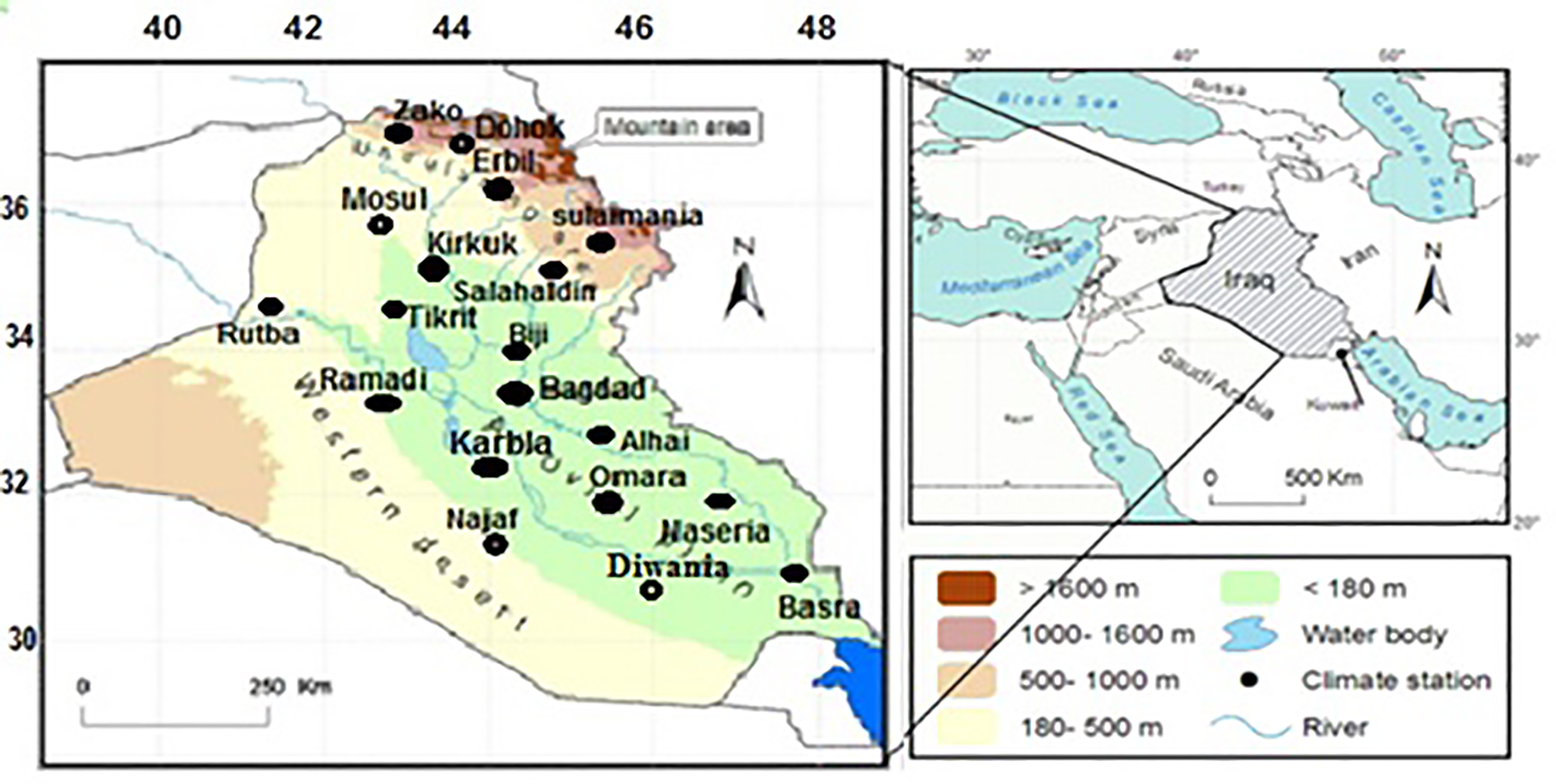
Iraq is a country located in southwestern Asia. While the central and southern regions are characterized by a plain region running from the middle to the south, the northern and northeastern regions are covered with mountains. A desert dominates the western area (Fig. 1). Low annual precipitation of 100 to 200 mm occurs in the central and southern parts of Iraq. In the northern region of Iraq, precipitation increases and averages approximately 1000 mm annually. Most of the year's rainfall, or around 90% of it, falls between November and March, the other months between April and October are dry, especially the warmest ones in the summer (Al-Falahi, 2008). The annual mean extreme maximum temperature of Iraq reached 49 °C especially in the central and southern regions, the annual mean minimum of temperature is below 8.5 °C. In the winter, the northern and northeastern parts see minimum temperatures around freezing, while the alluvial plains of southern Iraq experience minimum temperatures between 4 °C and 5 °C. Minimum temperatures in the summer range from 22.2 °C to 29 °C (Salar, 2013).
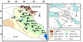
A map of Iraq's geography with weather stations (Shuttle Radar Topography Mission (SRTM), at resolution 90 m)).
3. Data and Methodology
The available observations data for temperature and precipitation have been provided by the Iraqi meteorological organization for the winter and spring periods (1981-2010), which correspond to Iraq's rainy seasons. Therefore, only these two precipitation seasons will be presented for all 18 stations shown in Fig. 1 except Rutba. The temperature data were collected from 8 stations (Mosul, Kirkuk, Baghdad, Rutba, Alhai, Diwania, Naseria, and Basra) across all seasons during the time period of 1971-2010.
To assess the homogeneity, which refers to a well-known statistical technique to identify the trend in the time series and recognize if there are index to climate change or its only small variations influence on the climatological parameters of the data at a 95% confidence level, the Pettitt's Test in the XLSTAT software was employed to detect the point of change. This test is the non-parametric rank test that can reveal the break point (month or year) at continuous data; the null hypothesis of this test is that data are independent and randomly distributed. This means that data follow the same distribution (Pettitt, 1979). The principal component analysis method was utilized to extract the principal components (PCs) of the two climatological parameters, which were then examined for their correlation with 850 hPa geopotential field. The geopotential height monthly data was extracted from the 20th-century reanalysis V2 (Compo et al., 2011), with a resolution of 1x1 degree. A correlation map was constructed to highlight the relationship between the Iraqi climatological parameters and the geopotential 850 hPa.
4. Results
4.1. Iraqi precipitation homogeneity
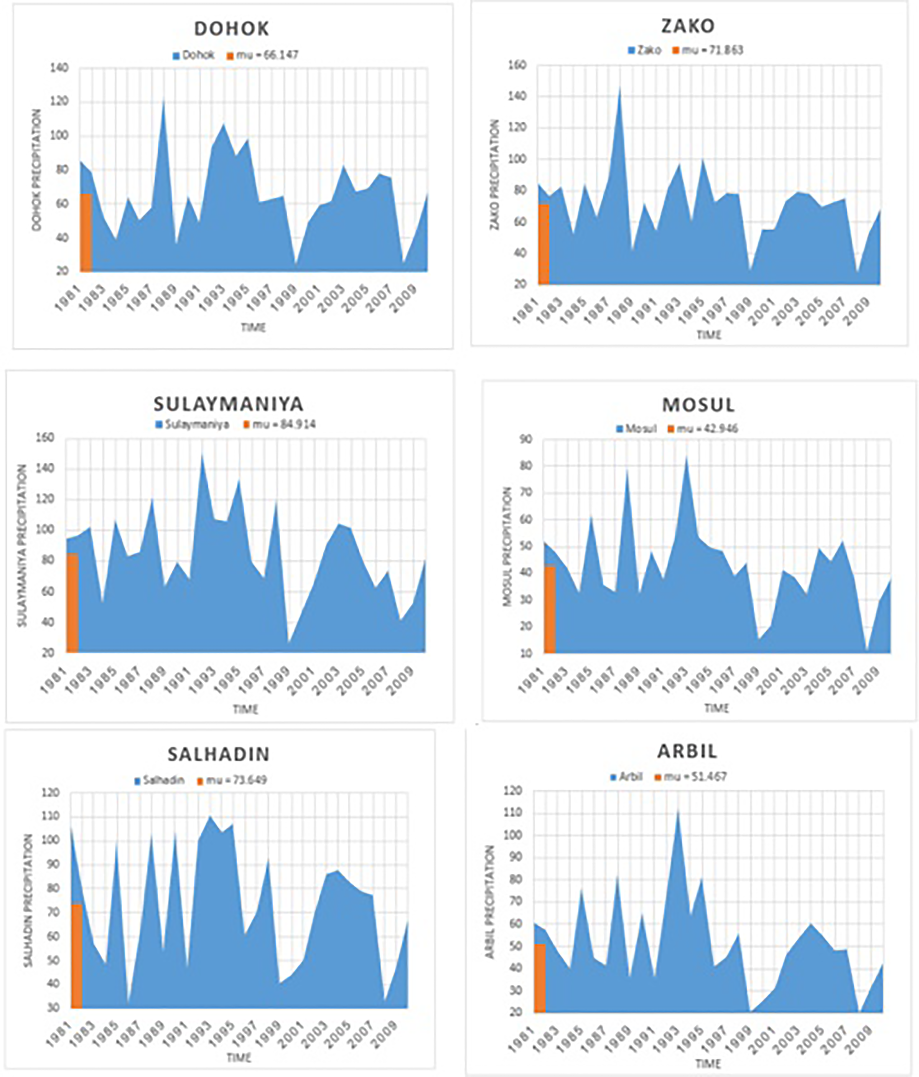
The homogeneity of annual precipitation in Iraq was investigated. The study focused on 18 stations and analyzed data from the period 1981-2010. To simplify the analysis, the precipitation stations were divided into three groups (every 6 stations) based on their location: north, middle, and south. The north mountain stations (Fig. 2) exhibited consistent mean values over the study period, indicating homogeneity. However, the Zako station in the northeastern region of Iraq recorded the highest annual precipitation of 1255 mm in 1992, which was the year with the most rainfall among the northern stations. Nonetheless, this station also had a higher standard deviation (221.6) compared to the other stations. Conversely, the lowest precipitation value of 97.2 mm was observed at the Mosul station (Table 1). Most of the northern stations experienced three distinct time periods of precipitation (1983-1988, 1990-1998, and 2000-2008), indicating a frequency of precipitation roughly every eight years. However, there were very few rain showers in the years 1999 and 2009.
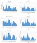
the homogeneity of the Iraq precipitation (north stations) for the 1981-2010 time period, mu1 refer to the mean of the precipitation.
statistical parameter of the Iraqi precipitation of 18 stations for the 1981-2010 time period.
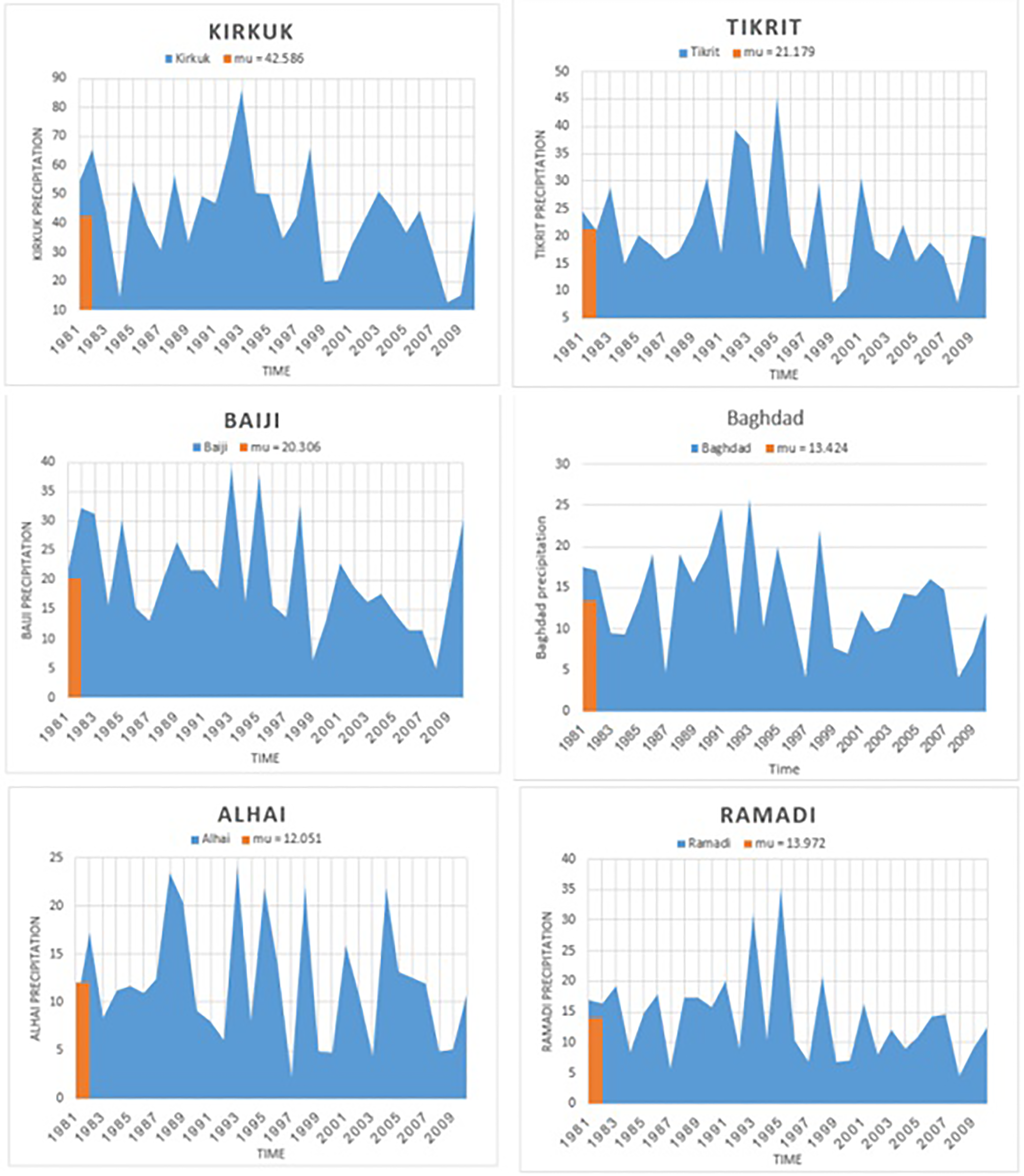
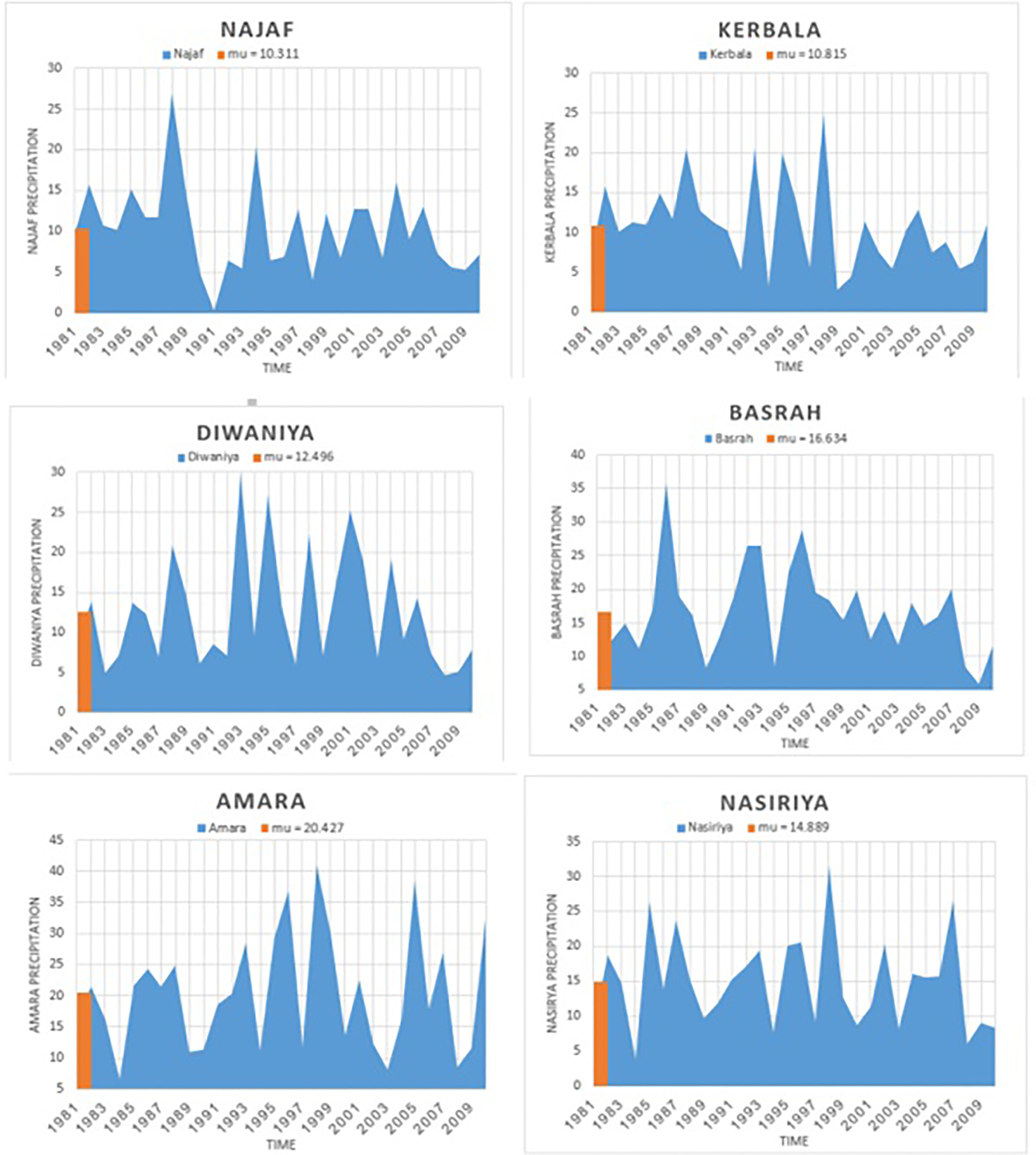
The middle stations (Fig. 3) also exhibited homogeneity. The three stations located above Baghdad (Kirkuk, Baiji, Tikrit) showed a similar pattern of minimum precipitation years and periodicity as the northern stations, with lower average rainfall. Among them, Kirkuk recorded the maximum precipitation value of 694.1 mm. On the other hand, the other three middle stations had different patterns and frequencies compared to the aforementioned three stations. The minimum precipitation values were recorded in 1997 and 2008, with the lowest value of 19.6 mm at the Alhai station, located south of Baghdad. Similarly, the south stations (Fig. 4) displayed homogeneity, but with lower precipitation compared to the previous stations. The minimum precipitation of 2.4 mm was recorded at the Najaf station in 1991, whereas the Omara station recorded a value of 331.4 mm in 1998, which was considered one of the years with the highest precipitation for the south stations.
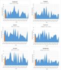
the homogeneity of the Iraq precipitation (middle stations) for the 1981-2010 time period, mu1 refer to the mean of the precipitation.
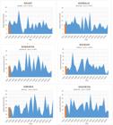
the homogeneity of the Iraq precipitation (south stations) for the 1981-2010 time period, mu1 refer to the mean of the precipitation.
In summary, the annual precipitation in Iraq was found to be homogeneous. However, the specific characteristics varied due to the orography and different climate patterns observed throughout the study period.
4.2. Iraqi temperature homogeneity
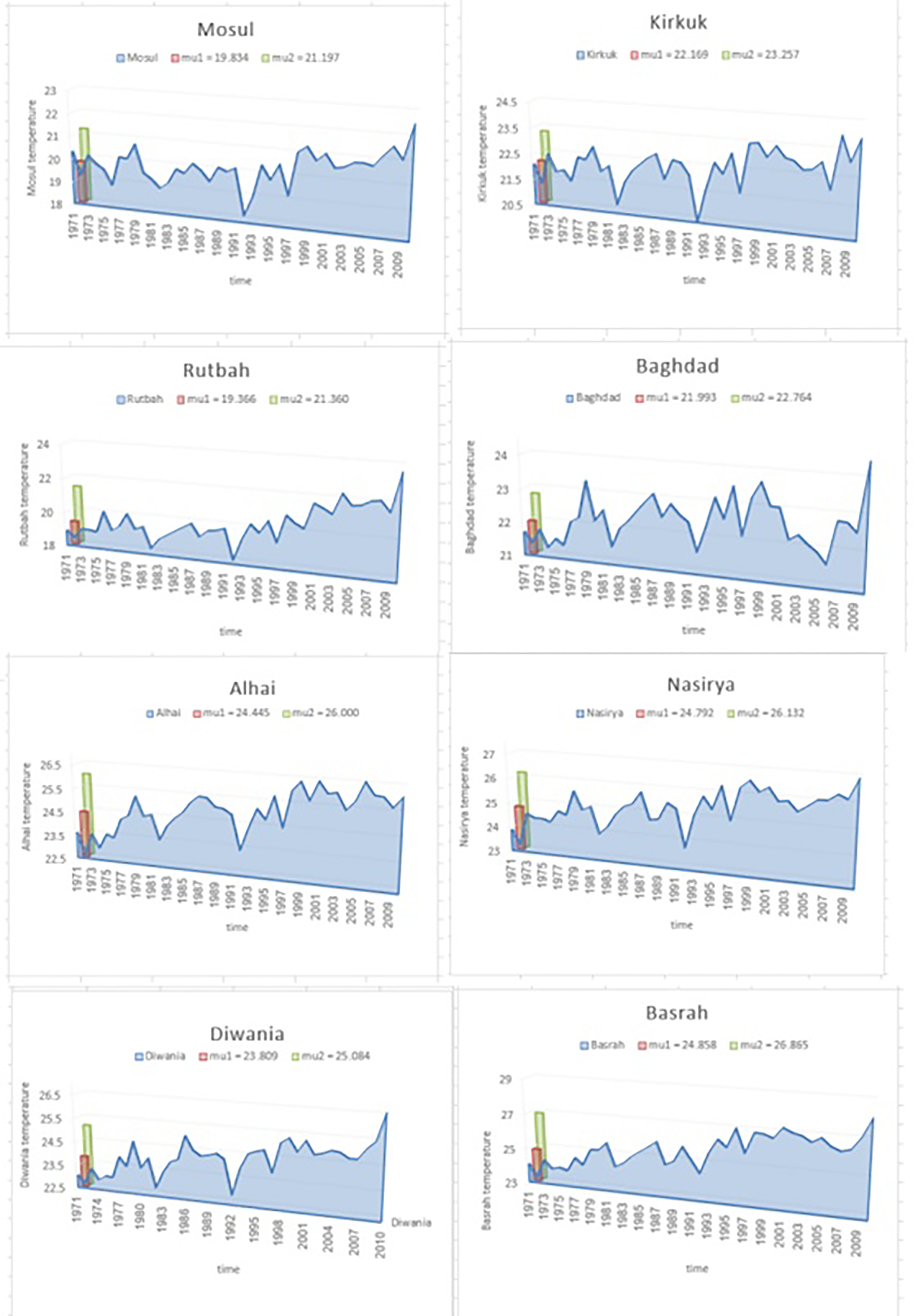
The homogeneity of annual temperatures in Iraq was also investigated. The study identified temperature characteristics at eight stations for the time period between 1971 and 2010. The results showed that the Iraqi temperature exhibited heterogeneity over the course of the study (Fig. 5). There were two distinct regimes observed, each with its own mean temperature (mu) over the time period, this value reflects the magnitude of the shift or difference between two segments of the time series, before and after the potential change point. The higher the value of Ut, which refers to a test statistic at time (t) that is used to detect a change point in the data series), if the maximum value of ∣U∣ is statistically significant, the test rejects the null hypothesis of homogeneity and identifies a change point in the data, the more significant the difference between these two periods, the more pronounced shift in the climate data. The annual temperature varied, with the highest value recorded at the Basrah station (28.2 °C) and the lowest value recorded at Mosul (18.3 °C). Additionally, the standard deviation of temperature values was higher at the Rutba station, indicating greater variation from the mean (Table 2). Both Mosul and Kirkuk stations exhibited a similar change point of variation, with the shift occurring for the 1997-2010 time period, the values of Mu1 (the temperature mean of the first period) are 19.8 °C and 22.169 °C and for the shift point are 21.197 °C and 23.257 °C for the two stations respectively as in (Fig. 5), differ across these two periods, giving insight into whether climate patterns have shifted over time as in (Fig. 5). Moreover, Basrah, Nasryia, and Rutbah stations exhibited a second trend regime starting after 1993-2010, while Baghdad and Alhai stations had different time periods compared to the other station (Table 3). The minimum temperatures were recorded in the years 1982 and 1992, which also experienced significant precipitation at the same stations.
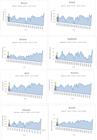
the homogeneity of the Iraq temperature (8 stations) for the 1971-2010 time period, mu1 refer to the temperature mean for the first period, mu2 refer to the temperature mean for the second period.
4.3. Relationship between Iraqi winter and spring precipitation with geopotential height Z850 hPa
We examine the relationship between the PCs of winter and spring precipitation in Iraq and the geopotential height at Z850 hPa. Our objective is to investigate the impact of Z850 hPa on Iraqi precipitation during the winter and spring seasons from 1981 to 2010.
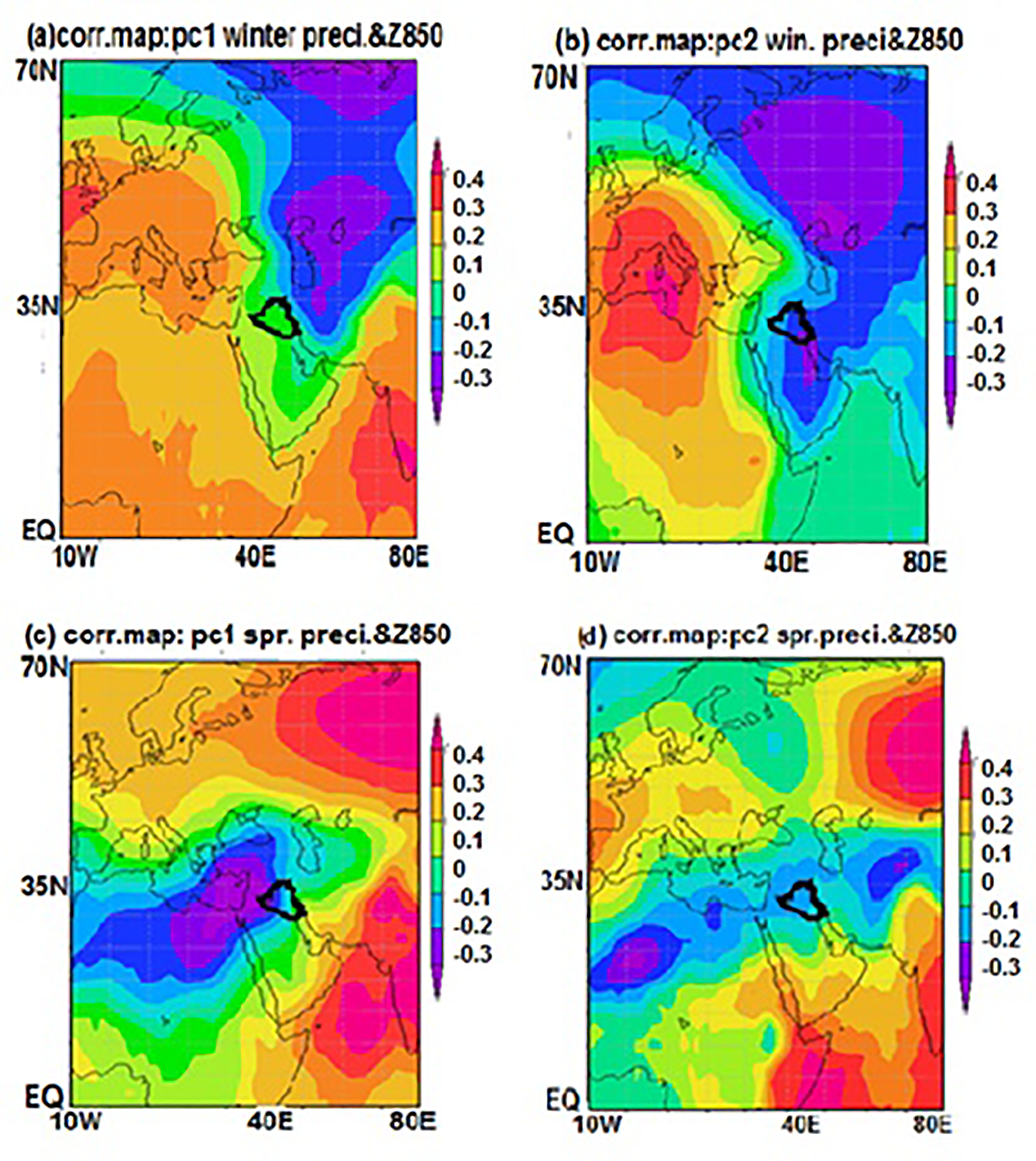
The first PC of winter precipitation in Iraq is connected to the presence of a low-pressure system associated with the polar cold air mass. This air mass descends from the polar region through Turkey and Iran, reaching the Iraqi area due to the northern wind's air advection. Consequently, the cold air covers the Iraqi region (Fig. 6a). Similarly, the second PC of winter precipitation exhibits a similar pattern, where the polar air mass brings cold air over Iraq (Fig. 6b).
Conversely, the first PC of spring precipitation in Iraq is linked to a low-pressure system centered over the Mediterranean Sea and North Africa. This system brings moist air to the Iraqi area through the air advection caused by the southeastern wind (Fig. 6c). Moreover, the correlation map of the second PC with Z850 hPa reveals a low-pressure band structure centered over North Africa and the Mediterranean Sea. This band is responsible for transporting moist air over the Iraqi region through the southeastern wind (Fig. 6d). In summary, the dominant factor influencing winter precipitation in Iraq is the polar low-pressure system, while the Mediterranean Sea and North Africa low-pressure band significantly influence spring precipitation.
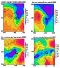
correlation maps: (a, and c) PC1, (b, and d) PC2 of winter and spring precipitation with Z850 hPa for the 1981-2010 time period. Black contour line marks the Iraqi border.
4.4. Link between Iraqi winter and spring temperature anomalies and geopotential height Z850 hPa
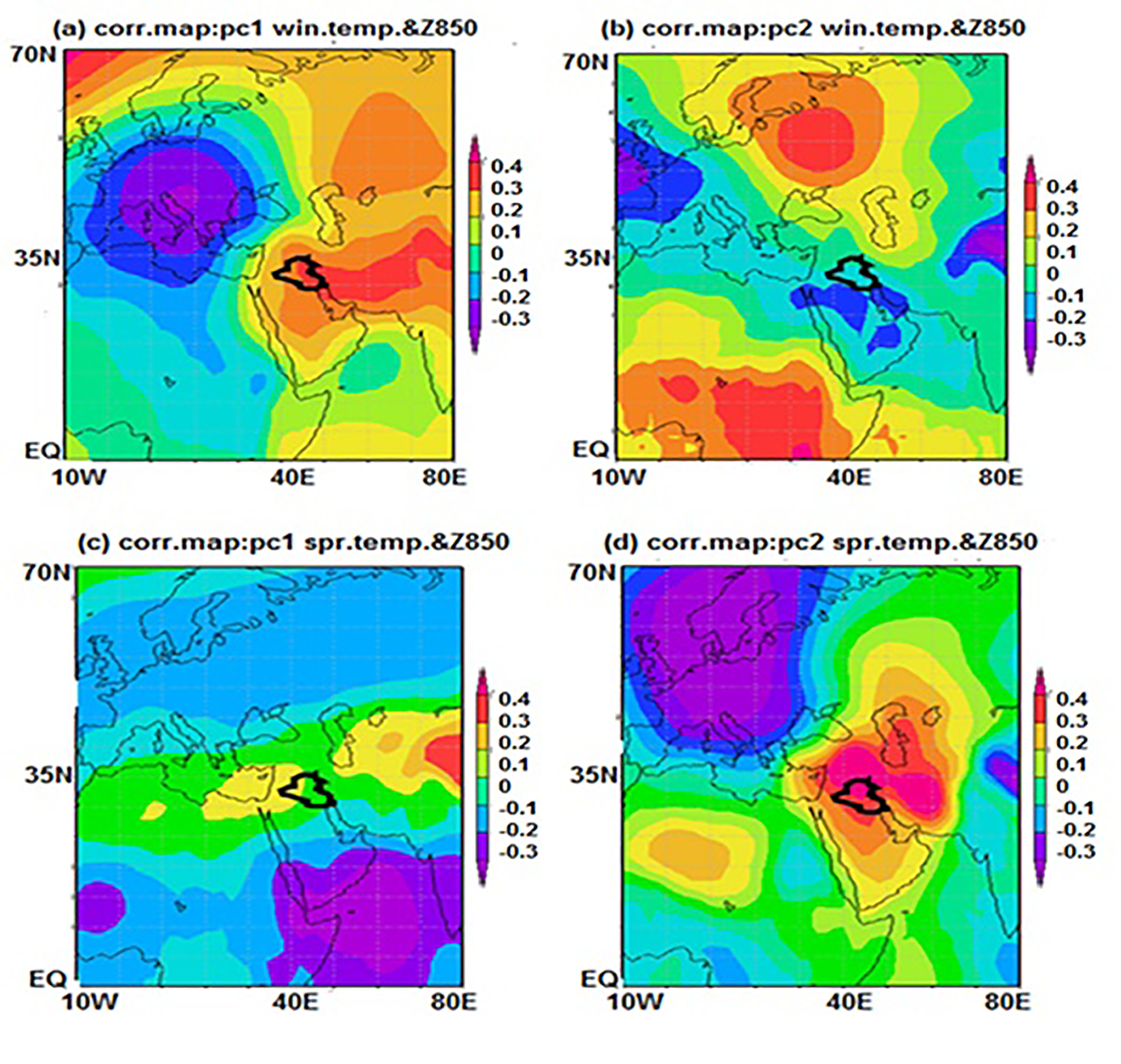
To investigate the relationship between Iraqi temperature anomalies and geopotential height Z850 hPa, we correlated the principal components (PCs) of Iraqi winter and spring temperatures with Z850 hPa for the 1971-2010 period. The correlation map of PC1 winter temperature with Z850 reveals a gradient pressure over the Middle East region, associated with warm air from the Arabian Peninsula and cold air from a low-pressure system centered over Europe (Fig.7a). Additionally, the second PC corresponds to a low-pressure system that brings cold air from Europe via the Mediterranean region to Iraq, carried by northeastern winds (Fig. 7b). In spring, PC1 of Iraqi temperature is linked to high pressure over North Africa and the Mediterranean Sea, resulting in warm, moist air flowing over Iraq from the east (Fig. 7c). Furthermore, the correlation map of the second PC of spring temperature corresponds to a high-pressure system centered over the Iraqi region, associated with warm air from the Arabian Peninsula and carried by southeastern winds (Fig. 7d). In summary, Iraqi winter and spring temperature anomalies are associated with the Mediterranean low-pressure mode and the high-pressure structure over the Arabian Peninsula.
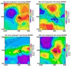
correlation maps: (a, and c) PC1, (b, and d) PC2 of winter and spring temperature with Z850 hPa for the 1971-2010 time period. Black contour line marks the Iraqi border.
4.5. Link between Iraqi summer and autumn temperature anomalies with geopotential height Z850 hPa
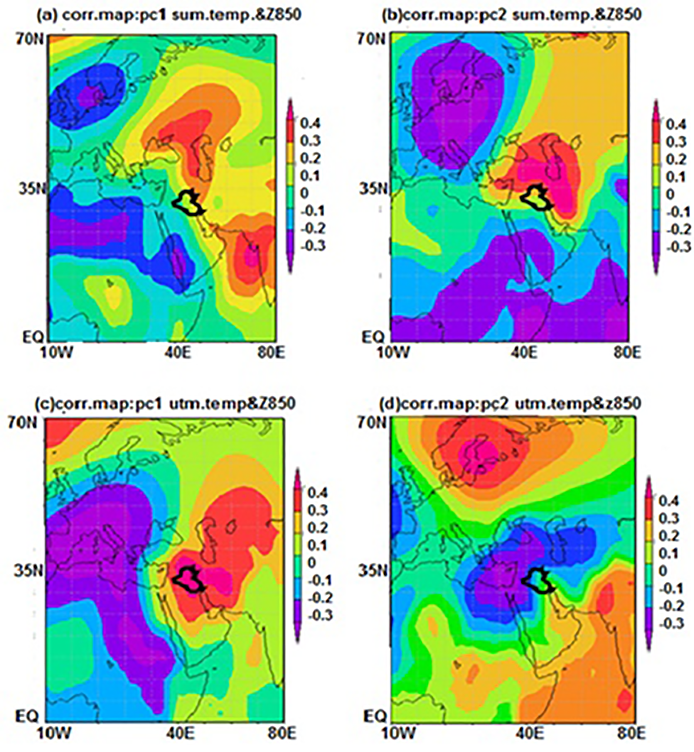
To investigate the relationship between Iraqi summer and autumn temperatures and geopotential height, we performed correlation analyses using the principal components (PCs) of temperature anomalies for the respective seasons and Z850 hPa data from the time period of 1971-2010. The correlation map for the first PC of summer temperature and Z850 shows a pressure gradient centered over the Iraqi region. This gradient results from the advection of southwestern wind carrying hot air masses originating from India and eastern Africa, which leads to the transportation of hot air over the Arabian Peninsula and Iraqi region through the southeastern wind advection (Fig. 8a). Similarly, the correlation map for the second PC of summer temperature and Z850 indicates the presence of a high-pressure system of hot air mass over the Iraqi region, which results in the transportation of hot air over Iraq through the southwestern wind (Fig. 8b).
Moreover, we found a connection between autumn temperature anomalies and Z850 hPa. The correlation map for the first PC of autumn temperature anomalies and Z850 reveals a high-pressure system of hot air mass centered over the Iraqi area, which causes the transportation of hot air through the southwestern wind (Fig. 8c). On the other hand, the correlation map for the second PC exhibits a different pressure system, with a low-pressure center over the Mediterranean region and Red Sea. This configuration leads to the advection of moist air over Iraq through the southeastern wind, contributing to wet conditions (Fig. 8d).
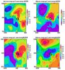
correlation maps: (a, and c) PC1, (b, and d) PC2 of summer and autumn temperature with Z850 hPa for the 1971-2010 time period. Black contour line marks the Iraqi border.
5. Conclusion and Discussion
The results of the study contribute to our understanding of the homogeneity of Iraqi precipitation and temperature, as well as the influence of geopotential height at 850 hPa on climate variations in Iraq. The main findings are as follows:
-
1-
Iraqi precipitation shows consistent patterns over time, while temperature data from the eight stations exhibit a noticeable shift after 1993 and 1997.
-
2-
Winter precipitation in Iraq is influenced by polar cold air, while the advection of moist air from the Mediterranean Sea and North Africa plays a key role in spring precipitation, specifically associated with geopotential height at 850 hPa (Z850 hPa).
-
3-
Winter temperature in Iraq is influenced by the pressure gradient system in the region, with warm air advection from North Africa and the Mediterranean being the controlling factor in springtime.
-
4-
Summer and autumn temperatures in Iraq are influenced by the advection of hot air from India and eastern Africa through the Arabian Peninsula to the Iraqi region.
Additionally, a significant change in Iraqi temperature is observed after 1993 and 1997, possibly indicating an influence from El Niño years. This aligns with similar findings by (Alsarmi and Washington, 2011) on climate change in the Arabian Peninsula, where multiple change points were identified after mid-1997 due to the El Niño pattern effect.
The study reveals that Iraqi precipitation and temperature are affected by the region's altitude and are associated with various climate patterns. (Alkhalidi et al., 2016) Found that the Empirical Orthogonal Functions (EOFs) of Iraqi temperature and precipitation are influenced by large-scale modes and the area's orography. Furthermore, Iraqi precipitation anomalies are associated with polar cold air and moisture-laden air from the Mediterranean Sea and North Africa at Z850 hPa. A similar study by (Alkhalidi et al., 2017) examined Iraqi precipitation in relation to surface pressure and identified a link to North Atlantic Oscillation (NAO) patterns, which affect the Iraqi region through the advection of water vapor from North Africa. In the case of Iraqi summer and autumn temperatures, they are connected to the advection of hot air from India and Africa through the Arabian Peninsula to Iraq. This aligns with the findings of (Alkhalidi et al., 2017), who identified a link between surface pressure over the Indian Ocean and Iraqi temperature, as warm air is transported over the Indian Ocean and Africa before reaching Iraq through the Arabian Peninsula.
Acknowledgments
We are grateful and grateful to the College of Science at the University of Diyala, We would like to thank Iraq meteorological organization to provide the required data to researchers.
References
- ALAMODI, A.O.; MASHAT, A.S.; ABDEL BASSET, H.M. On the Relation Between Atmospheric Pressure Systems and Rainfall Prediction Over the Kingdom of Saudi Arabia Jeddah: King Abdelaziz University press, Kingdom of Saudi Arabia, 2008.
- AL-FALAHI, A.A. Middle East Water and Livelihoods Initiative Aleppo: International Center for Agricultural Research in the Dry Areas, v. 7, n. 9, p.7-9, 2008.
- ALKHALIDI, J.; DIMA, M.; STEFAN, S. Large-scale modes impact on Iraqi climate variability. Theoretical and Applied Climatology, v. 124, n. 1-2, p. 1-12, 2016.
- ALKHALIDI, J.; DIMA, M.; VAIDEANU, P.; STEFAN, S. North Atlantic and Indian Ocean sectors link with Iraqi climate. Atmosphere, v. 8, n. 12, p. 235-247, 2017.
- ALMAZROUI, M.A.; AL KHALAF, A.K.; ABDEL BASSET, H.M.; HASANEAN, H.M. Detecting Climate Change Signals in Saudi Arabia Using Surface Temperature. Jeddah: King Abdelaziz University press, Kingdom of Saudi Arabia, 2009.
- ALSARMI, S.; WASHINGTON, R. Recent observed climate change over the Arabian Peninsula. Journal of Geophysical Research, v. 116, n. D11109, 2011.
- COMPO, G.P.; WHITAKER, J.S.; SARDESHMUKH, P.D.; MATSUI, N.; ALLAN, R.J.; et al. The Twentieth Century reanalysis project. Journal of the Royal Meteorological Society, v. 137, n. 654, p. 1-28, Jan, 2011.
- HASANEAN, H. Teleconnection between global climatic events, atmospheric circulation change and stream flow over the River Nile. Journal of Meteorology, v. 28, n. 279, p. 161-177, 2003.
-
MAIER, N. Variation of Air Temperature at 850 hPa in Northwest Romania Aerul si Apa: Componente ale ediului, 2015. doi
» https://doi.org/10.17378/AWC2015_25 - NASRALLAH, H.A.; BRAZEL, J.; BALLING, R.C. Analysis of the Kuwait City urban heat island. International Journal of Climatology, v. 10, n. 4, p. 401-405, 1990.
- NASRALLAH, H.A.; NIEPLOVA, E.; RAMADAN, E. Warm season extreme temperature events in Kuwait. Journal of Arid Environments, v. 56, n. 3, p. 357-371, 2004.
- PETTITT, A.N.A non-parametric approach to the change point problem. Journal of the Royal Statistical Society: Series C., v. 28, n. 2, p. 126-135, 1979.
- SAHSAMANOGLOU, H.S. A contribution to the study of action centers in North America. International Journal of Climatology, v. 10, n. 3, p. 247-261, 1990.
- SALAR, A. Climate of Iraq Baghdad: Baghdad University press, Iraq, p. 134-136, 2013.
- SARRONI, H.; BITAN, A.; ALPERT, P.; ZIV, B. Continental polar outbreaks into the Levant and Eastern Mediterranean. International Journal of Climatology, v. 16, n. 3, p. 1175-1191, 1996.
- STEPHENSON, T. S.; VINCENT, L. A.; ALLEN, T.; MEERBEECK, C.J.; MCLEAN, N.; et.al Changes in extreme temperature and precipitation in the Caribbean region, 1961-2010. International Journal of Climatology, v. 34, n.4, p. 2957-2971, 2013.
- UCCELLINI, L.W.; KOCIN, P.J. The interaction of jet streak circulations during heavy snow events along the east coast of the United States, Weather and Forecasting, v. 2, n. 2, p. 289-308, 1987.
- WHITNEY, L.F. Relationship of the subtropical jet stream to severe local storms. Monthly Weather Review, v. 105, n. 5, p. 398-410, 1977.
- ZANGVIL, A.; DRULAN, P. Upper air trough axis orientation and the spatial distribution of rainfall over Israel. International Journal of Climatology, v. 10, n. 3, p. 57-62, 1990.
- ZHANG, X.; AGUILAR, E.; SENSOY, S.; MELKONYAN, H.; TAGIYEVA, U.; et.al Trends in Middle East climate extreme indices from 1950 to 2003. Journal of Geophysical Research, v. 110, n. D22104, p. 34-44, 2005.