 Deep learning and aerial imagery for macaúba palm identification
Abstract
The objective of this work was to use deep learning and images taken by unmanned aerial vehicles to develop a model to identify the occurrence of macaúba (Acrocomia intumescens) palm trees. The model was trained and tested using data from areas in the southern region of the state of Ceará, Brazil. Later, the tested model was evaluated using data from areas in the Midwestern region of the country. The primary challenge was to distinguish macaúba from other native palm trees, such as babassu (Attalea speciosa). Babassu has spectral similarities and a random distribution, which makes it difficult to identify. Red-green-blue mosaics were cropped into smaller size images and processed using a convolutional neural network deep-learning technique. Identification performance was evaluated using metrics of accuracy, precision, recall, and F1-score. In an area of 1,000 ha, 3,679 macaúba palm trees and 12,410 babassu palm trees were identified, achieving a 93% accuracy. The proposed approach was evaluated in a 4.0 ha site located in the municipality of Batayporã, in the southern region of the state of Mato Grosso do Sul, with an 89% accuracy. The model was able to identify macaúba palm trees occurring in natural areas in the Semiarid and in Midwestern regions of Brazil.
Index terms:
Acrocomia intumescens; bioeconomy; convolutional neural network; unmanned aerial vehicles; vegetable oil.
Resumo
O objetivo deste trabalho foi utilizar deep learning e imagens de veículos aéreos não tripulados para desenvolver um modelo para identificar a ocorrência de palmeiras de macaúba (Acrocomia intumescens). O modelo foi treinado e testado por meio de dados de áreas no sul do estado do Ceará, Brasil. Posteriormente, o modelo testado foi avaliado por meio de dados de áreas do Centro-Oeste do país. O principal desafio foi distinguir a macaúba de outras palmeiras nativas, como o babaçu (Attalea speciosa). O babaçu apresenta similaridades espectrais e distribuição aleatória, o que dificulta a identificação dessa espécie. Mosaicos vermelho-verde-azul foram recortados em imagens de tamanho menor e processados por meio de técnica de deep learning de rede neural convolucional. O desempenho da identificação foi avaliado com uso de métricas de acurácia, precisão, recall e F1-score. Em uma área de 1.000 ha, 3.679 palmeiras de macaúba e 12.410 de babaçu foram identificadas, tendo-se alcançado 93% de acurácia. A abordagem proposta foi avaliada em uma área de 4,0 ha, localizada no município de Batayporã, no sul do estado de Mato Grosso do Sul, com 89% de precisão. O modelo foi capaz de identificar a ocorrência de palmeiras de macaúba, em áreas naturais, no Semiárido e no Centro-Oeste do Brasil.
Termos para indexação:
Acrocomia intumescens; bioeconomia; rede neural convolucional; veículos aéreos não tripulados; óleo vegetal.
Introduction
Macaúba palm trees are widespread across tropical and subtropical America, including Brazil, particularly in open and drier areas (Morcote-Ríos & Bernal, 2001; Mota et al., 2011). In some regions, they have evolved into different ecotypes, some of them with greater predominance, such as Acrocomia sclerocarpa Mart., Acrocomia intumescens Drude, and Acrocomia totai Mart. (Madeira et al., 2024).
Macaúba products are valuable sources of vegetable oils and raw materials (Colombo et al., 2018; Cardoso et al., 2020). In the Northeastern region of Brazil, local communities extract some resources from macaúba palm trees using basic tools and domestic processes (Pires et al., 2023).
The domestication of macaúba has been towards a key source of biomass and oil for Brazil’s bioeconomy (Vargas-Carpintero et al., 2021). Macaúba thrives in areas unsuitable for African oil palm (Elaeis guineensis Jacq.) according to Ferrari & Azevedo Filho (2012), reaching 4,000 kg ha-1 oil annually, surpassing the oil production from soybean and cotton (Colombo et al., 2018).
Macaúba cultivation offers environmental benefits and can be grown in association with other crops, such as coffee, increasing the agricultural productivity (Moreira et al., 2018). However, its cultivation takes place in production establishments of small scale and unorganized ones (Moreira et al., 2018; Cardoso et al., 2020). While large-scale cultivation efforts are underway (Imaflora, 2020; Soleum, 2024), it will take time to see significant increases in production. Moreover, an effective management of macaúba will require knowledge about fruit availability, logistics, and fruit-processing technology.
In order to gather more information for macaúba cultivation, advancements in the use of remote sensing and deep learning provide significant advantage over methods that involve the visual interpretation of images. Remote sensing consists of collecting data of the Earth’s surface from aerial platforms, such as drones. Deep learning allows of the identification of complex patterns in large data volume, such as distinguishing between different types of vegetation, or detecting changes in land cover. These models can be trained to improve their performance continuously, as more data are collected. By automating image analysis, the identification process is accelerated and accuracy increased, reducing human errors.
Some studies showed success by combining remote sensing and deep learning in palm species recognition, achieving a high accuracy (Li et al., 2019; Mubin et al., 2019; Zheng et al., 2023).
Al-Ruzouq et al. (2024) explored some frameworks as unified perceptual parsing scene understanding network combined with deep-learning models, such as vision transformer, swin transformer, SegFormer, Mask2Former, and UniFormer, all of them used to delineate palm plantation crowns from high-resolution satellite images.
High-resolution images are essential to identify and differentiate palm species, mainly in natural environments, due to the presence of multiple species. The use of unmanned aerial vehicles (UAVs) allows of the capture of high-resolution imagery (centimeter scale). This is ideal to survey small areas (1.0 to 5.0 ha) and medium-sized areas (up to 100 ha). UAV has been highly effective for palm tree identification (Pidhirniak, 2019; Casapia et al., 2020; Ferreira et al., 2020). Studies using UAV images, combined with machine learning, achieved 79% accuracy rates to identify coconut trees (Pidhirniak, 2019), and 99% to tell apart different Amazonian palm species (Ferreira et al., 2020). UAVs offer significant advantages over manual counting. For instance, Ameslek et al. (2024) achieved near-perfect olive tree counts using high-resolution drone images and a template-matching technique. Beyond plant species identification, UAVs are being explored for plant health assessment as well (Gibril et al., 2024; Zhang et al., 2024).
The objective of this work was to use deep learning and UAV images to develop a model to identify the occurrence of macaúba (A. intumescens) palm tree.
Materials and Methods
Two study areas were selected for the present work, one of 1,000 ha total for model training and testing, and the other of 4.0 ha for evaluation of the tested model. The first area was divided into the municipalities of Barbalha and Crato, in the southern part of the state of Ceará, Brazil (between 7°18’S and 7°22’S, and between 39°22’W and 39°25’W). The region has a natural occurrence of the A. intumescens macaúba ecotype and babassu (Attalea speciosa Mart.). The local climate region is Aw, according to Köppen-Geiger’s climatic classification system, that is, tropical and dry season in the winter (Alvares et al., 2013). The average annual precipitation is 1,047.9±353.0 mm, out of which 66.3% is concentrated between January and April (Matos et al., 2018). The dominant soil type is Acrisol by FAO’s soil classification system, Ultisol by Soil Taxonomy, or Argissolo Vermelho eutrófico by the Brazilian Soil Classification System (IBGE, 2007; Santos et al., 2018). According to the digital elevation model, derived from the Advanced Land Observing Satellite (ALOS) AW3D30 mission (Tadono et al., 2016), the mean elevation is 648±48 m. In the 1,000 ha, there were 3,679 macaúba and 12,410 babassu palm trees.
The area of 4.0 ha used for evaluation of the tested model is located in the municipality of Batayporã, in the state Mato Grosso do Sul, in the Midwestern region of Brazil (between 22°28’47”S and 22°28’56”S, and between 53°05’47”W and 53°05’56”W. The 4.0 ha area is within a 200 ha area, where the macaúba ecotype A. totai prevails. There are differences between the canopies of A. intumescens and A. totai. The climate is Aw in this area, by Köppen-Geiger’s climatic classification system, i.e., tropical with a dry winter (Alvares et al., 2013). The mean annual precipitation is 1,212 mm, with a standard deviation of 298 mm (Inmet, 2020), out of which 74% is concentrated between October and March. The predominant soil type is Arenosol, by FAO’s soil classification system (IUSS Working Group WRB, 2015), Entisols in Soil Taxonomy, or Neossolo Quartzarênico by the Brazilian Soil Classification System (Santos et al., 2018). According to the digital elevation model derived from the ALOS AW3D30 mission (Tadono et al., 2016), the average height is 251±2.4 m.
Images of the areas in Barbalha and Crato were captured in February 2017, using the Phantom 4 UAV (DJI, Shenzhen, China), equipped with a 12.1 MP resolution red-green-blue camera with 20 mm lens (Figure 1). The flight path included parallel strips with 60% lateral and longitudinal overlaps. The post-processing resulted in orthoimages presenting a 5.0 cm ground sampling distance.
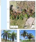
Red-green-blue color composite image showing occurrences of the studied palm trees in the municipality of Barbalha, in the state of Ceará state, Brazil: A, macaúba (Acrocomia intumescens) and babassu (Attalea speciosa), represented by blue and red squares, respectively; B, macaúba canopy; and C, babassu canopy.
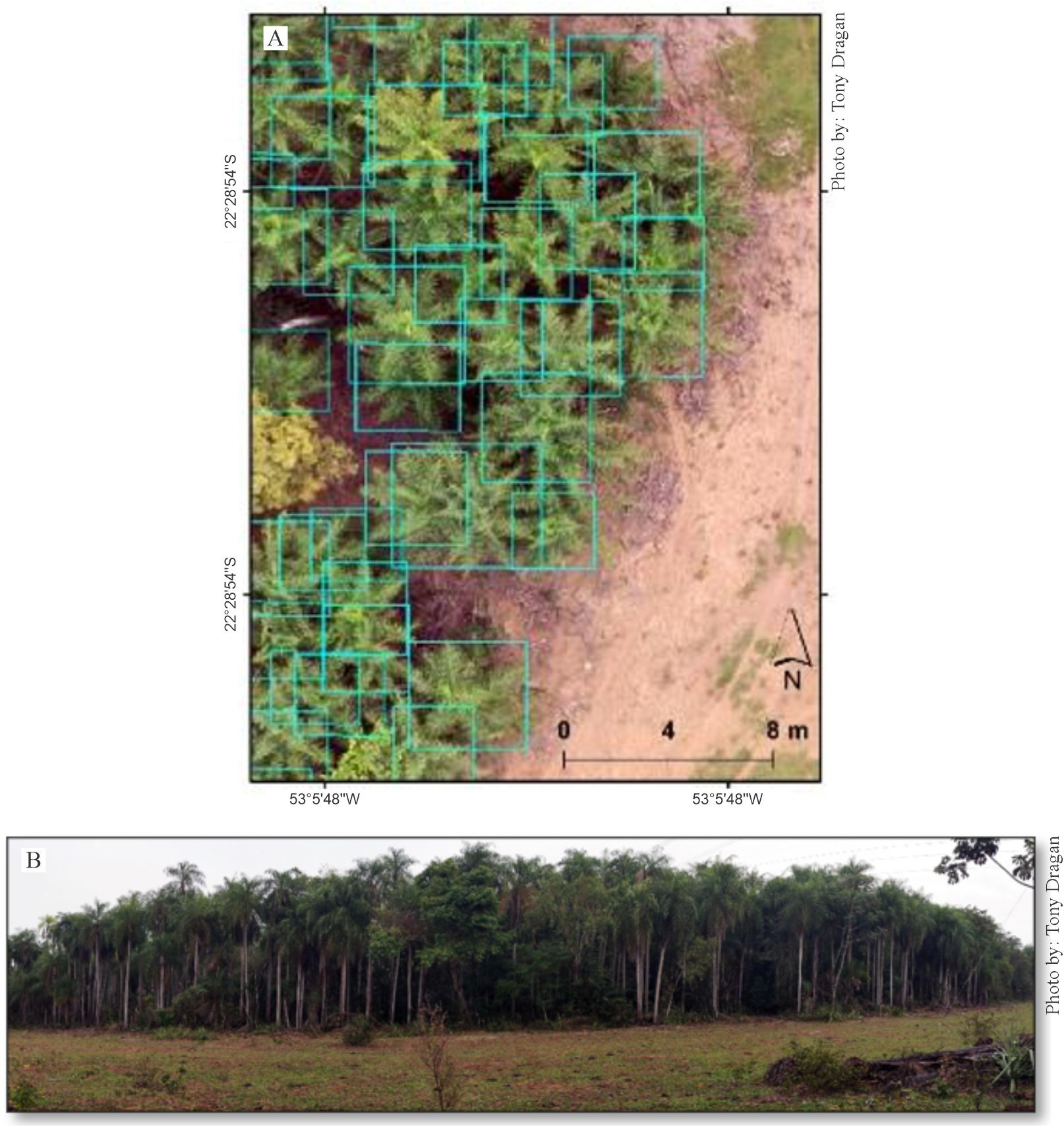
Images of the area in Batayporã were captured in May 2022, using the Mavic 2 Pro (DJI, Shenzhen, China) equipped with the Hasselblad L1D-20c camera with a 20 MP resolution (Figure 2). The flight path included parallel strips with 80% lateral and longitudinal overlaps. The post-processing resulted in orthoimages presenting a 3.0 cm ground sampling distance.

Occurrence of macaúba (Acrocomia intumescens) palm trees: A, red-green-blue color composite image showing bounding boxes; and B, panoramic photo of the macaúba grove study area in the municipality of Batayporã, in the state of Mato Grosso do Sul, Brazil.
The deep-learning process involved the five following steps: subdivision of the large mosaic into smaller images; manual annotation of the macaúba and babassu species; partitioning of training dataset and testing dataset; implementation of convolutional neural network (CNN) deep-learning classification and parameter configuration; and calculation of inference metrics for each palm species (classes) independently of the training dataset.
A Python script was written to divide the obtained mosaic of overlapped images into a set of smaller 1,000×1,000 px square images. The goal was to facilitate a manual annotation and reduce computational load. Images without macaúba or babassu were excluded from the set, which resulted in 1,544 square images containing at least one palm tree. The training dataset comprised 1,235 square images randomly selected as 80% of the total collection. The testing dataset was the remaining 309 square-images.
The open-source graphical image annotation tool LabelImg1 (Tzutalin, 2015) was used to make the annotation XML file of each square image. The classes “macaúba” and “babassu” were annotated as rectangular boxes. The expert team, some of them authors of the present study, labeled and reviewed the images, checking for mismatches through on-site inspections (reference data acquisition).
All images were labeled and saved as XML Pascal VOC format (80% for training, and 20% for testing). The application programming interface TensorFlow (Pang et al., 2020) was used for object detection. Among several pre-trained models in TensorFlow, the following ones were used: the Centernet architecture; and a one-stage anchor-free object detector model, together with the Resnet50, as its backbone network, which is a CNN. The model parameters were set to a batch size of 2, and the number of iterations of the training process, to 25,000 steps. The performance of the trained model was evaluated. In order to verify the predictions of the training model, a field inspection was conducted. The number of inspections necessary was calculated based on a sample size calculation formula (equation 1) proposed by Naing (2003). The population size was 309 square images of the testing dataset. The error accepted was 5%. The calculated number of field inspections was 174 square images. However, only 98 square images were evaluated, due to accessibility challenges and access restrictions into private farms. The quality of the inspections was evaluated through the Cohen’s kappa coefficient of agreement (Cohen, 1960).
where n is the number of inspections, N is the population size, and E is the level of precision.
A confusion matrix of two classes (“macaúba” and “babassu”) was used to assess the training model performance. For the “macaúba” class, the confusion matrix showed the following results: true positives (TP), which are correct predictions of true macaúba palm trees; true negatives (TN), which are correct predictions of true babassu palm trees; false positives (FP), which are predictions of macaúba that were actually babassu palm trees; and false negatives (FN), which are predictions of babassu that were actually macaúba palm trees. The same logic was applied to the “babassu” class.
From the results of the confusion matrix, four metrics were computed: accuracy, precision, recall, and F1-score, according to the respective following equations:
where Ac is accuracy for both classes, considered the proportion of all correct classifications of macaúba and babassu given the total classifications; Pr is precision for the “macaúba” class, defined as the proportion of the correct classifications of macaúba, given the correct (true) and incorrect (false) classifications of this species; Re is recall, the proportion of correct classifications of macaúba, given all macaúba palm trees that really exist in the area; and F1-score, also known as harmony mean, is a balanced measure of the model performance, which is useful in dealing with imbalanced datasets as the ones in the present study. F1 is low (imbalanced), when either precision or recall is low, which means that the model performance lacks both. A high F1 score is achieved only when precision and recall are both high, i.e., the model has a good performance for both. F1 scores close to F1 = 1 are considered “high” (balanced performance), while those close to zero are “low” (imbalanced performance). The same logic was applied to the “babassu” class for all metrics.
Based on the model obtained for the palm identification, it was possible to estimate fruit and oil productions on a given area. A set of 20 macaúba palm trees was randomly selected in the study area of Barbalha. They were classified into three growing stage categories: “young in establishment”, “established young”, and “adult”. The growing stage of macaúba palm trees was estimated for the canopy area. “Young in establishment” has a less than 1.0 m2 canopy area; an “established young” has a canopy area between 1.0 and 3.0 m2; and “adult” has a more than 3.0 m2 canopy area. The CNN-based identification process generated a bounding box around the plant with its geographic coordinates. This box was transformed into a circle around the plant, and the area of the circle was calculated. This area was used to classify the palm trees into the growing-stage categories. When available, bunches from these palms were collected at full fruit ripeness stage. All collected fruit were detached and weighed. A sample of 10 fruit per bunch of each palm was taken. The selected fruit were measured for moisture and dry-matter contents. Oil content was estimated. The dry-matter content of the fruit was determined gravimetrically. Fruit were put in an oven at 105°C, until reaching a constant mass, in order to determine dry matter. The difference between fresh fruit weight and the dry-matter weight was the moisture content. The pulp oil content was calculated as 30% of fruit dry-matter weight (Silva et al., 2015), and the kernel oil content was calculated as 50% of fruit dry-matter weight (Conceição et al., 2015). The potential fruit production of a given area was estimated multiplying the number of fruit by the number of macaúba palm trees classified as “established young” and “adult”. The same logic was used to estimate the fruit biomass and oil content. The oil content was estimated by assuming the recovery of 100% oil.
A laptop with Intel(R) Core (TM) i7-7700HQ CPU 2.80 GHz, 16 GB of memory, featured with a graphic board NVIDIA GeForce GTX 1050 Ti with 4 GB VRAM, was used. The compute unified device architecture was used as the parallel computing platform, in its version 11.4. Scripts written in Python were used for all procedures in the present study.
Results and Discussion
The confusion matrix for the class “macaúba” showed 88.2% TP, 97.7% TN, 2.3% FP, and 11.6% FN. The metrics for the class “macaúba” showed 97.5% precision, 88.4% recall, and F1 = 92.7%. For the “babassu” class, the confusion matrix showed 97.7% TP, 88.2% TN, 11.6% FP, and 2.3% FN. The metrics for the “babassu” class were 89.4% precision; 97.7% recall, and F1 = 93.4%. The kappa index calculated was 0.851, which indicates a nearly perfect agreement between field inspection and model predictions (Landis & Koch, 1977).
The model achieved 93.0% accuracy for both classes, that is, the model predicts correctly 93.0% of the overall classifications. Just taking into account the predictions of class “macaúba”, the model classifies correctly 95.5% of the events (precision). The prediction model has a worse precision for “babassu”. Taking into account the real number of macaúba palm trees, the model classifies correctly 88.4% of them (recall). For the class “babassu”, the model classifies correctly 97.7% of the real number of babassu palm trees. The overall performance is similar for both classes for the F1-score.
Previous publications have already reported the potential of deep learning for classifying palm trees (Casapia et al., 2020; Ferreira et al., 2020; Zhang et al., 2024), mainly in monocultures.
The model classifies macaúba palm trees better than babassu ones, when it finds them in the image, but it has more difficulty to find them in the image. For babassu palm trees, it is the opposite. In the images, the model finds babassu more easily than macaúba palm trees. However, when it finds babassu palm trees, it has a worse performance for classifying them. Notwithstanding, for both classes, the balance between precision and recall is similar, with a better precision for the class “macaúba”, and better recall for the class “babassu”.
The lower F1-score for the class “macaúba” may be related to three aspects. One aspect is the imbalance of the classes during the training phase, when the number of macaúba palm trees was much smaller than that of babassu. In the test dataset, the model predicted 666 macaúba and 2,102 babassu palm trees. The second aspect is the structural similarity between the adult macaúba and the young babassu. Third aspect, the field evaluation was conducted only after prediction, rather than during the annotation phase.
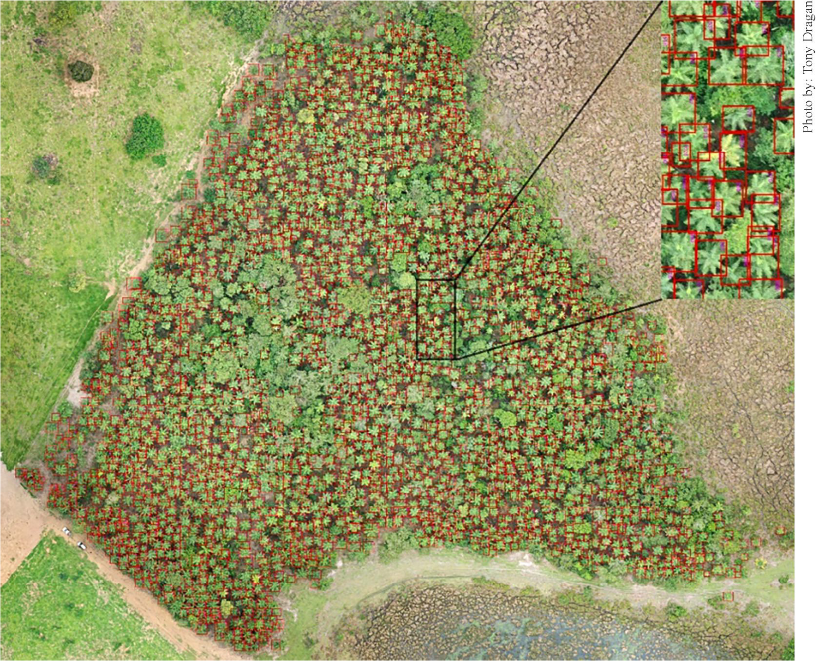
The model trained and tested for the A. intumescens ecotype, in the state of Ceará, was used in the municipality of Batayporã, in Mato Grosso do Sul state. Despite the different conditions, the model achieved 89% accuracy for the class “macaúba”. In comparison with the previous results, this lower value can be attributed to canopy overlap among individuals in Batayporã. Palm trees in this area exhibited a more uniform size and well-defined canopies than the individuals in Ceará state. These aspects led to a higher-quality image capture. The model detected 2,327 individuals (Figure 3), including 151 overlap errors. In addition, 69 macaúba palm trees were not detected, and 33 palm trees were misclassified as macaúba.

Macaúba (Acrocomia intumescens) palm trees identified by the convolutional neural network algorithm and shown in red in an red-green-blue color composite of the unmanned aerial vehicle-based mosaic, in the study area located in the municipality of Batayporã, in the state of Mato Grosso do Sul, Brazil.
The results for fruit and oil production of macaúba palm trees from Batayporã showed that fresh fruit production per plant was between 28 to 148 kg, with the average of 81 kg per plant (Table 1). These results for production were used to estimate the fruit and oil production of the 1,000 ha of the study area of the state of Ceará. The CNN model detected 3,458 macaúba palm trees from the 3,679 found in the area. The model classified 2,481 macaúba palm trees as “established young”, and 977 as “adult”, totaling 3,458 individuals. The estimated oil production was 10 Mg from the pulp, and 5.6 Mg from the kernel (Table 1).
Mean and total fresh matter mass of macaúba (Acrocomia intumescens) fruit and their parts, as well as estimated oil yield from a natural population evaluated in the region of Cariri in the state of Ceará, Brazil.
Although the proposed classification model using aerial images from UAV performs enough to detect macaúba palm trees and estimates oil production, some limitations were identified. A random selection of large samples in the field was compromised, due to problems of access to remote areas and private areas. The use of rectangular bounding boxes compromised the accurate detection of the canopy shape due to the presence of ground cover in the image.
Conclusions
-
1. The tested model is able to identify macaúba (Acrocomia intumescens) palm trees occurring in natural areas in the Semiarid region of Brazil, specifically in the state of Ceará.
-
2. The identification model can successfully find macaúba palm trees in another region in the state of Mato Grosso do Sul, in Southern Brazil.
-
3. It is possible to estimate oil production using data from the identification model.
Declaration of use of AI technologies
During the preparation of this work, the authors used ChatGPT (OpenAI) in order to improve English language clarity and correct grammar. After this use, the author(s) reviewed and edited the content as needed and take(s) full responsibility for it.
Acknowledgments
To International Fund for Agricultural Development (IFAD) - Programme for the Development of Alternative Biofuels Crops, under the scope of the Technical Cooperation Project number 23900.14/0059-3, among ICRAF, Embrapa, and Eliseu Alves Foundation; to Ministério da Agricultura, Pecuária e Abastecimento (MAPA) - Decentralized Execution Agreement - Process Number 21000.074917/2019-39; Conselho Nacional de Desenvolvimento Científico e Tecnológico (CNPq) grant PQ 400092/2020-4; to Flamboyant Farm (in the municipality of Batayporã, in the state of Mato Grosso do Sul, Brazil) and Tony Dragan, for the photos acquisition to evaluate the model application.
Disclaimer/Publisher’s note:
The statements, opinions, and data contained in all texts published in Pesquisa Agropecuária Brasileira (PAB) are solely those of the individual author(s) and not of the journal’s publisher, editor, and editorial team, who disclaim responsibility for any injury to people or property resulting from any referred ideas, methods, instructions, or products.
The mention of specific chemical products, machines, and commercial equipment in the texts published in this journal does not imply their recommendation by the publisher.
Data availability statement
Data available upon request: research data are only available upon reasonable request to the corresponding author.
References
-
AL-RUZOUQ, R.; GIBRIL, M.B.A.; SHANABLEH, A.; BOLCEK, J.; LAMGHARI, F.; HAMMOUR, N.A.; EL-KEBLAWY, A.; JENA, R. Spectral-spatial transformer-based semantic segmentation for large-scale mapping of individual date palm trees using very high-resolution satellite data. Ecological Indicators, v.163, art.112110, 2024. DOI: https://doi.org/10.1016/j.ecolind.2024.112110
» https://doi.org/10.1016/j.ecolind.2024.112110 -
ALVARES, C.A.; STAPE, J.L.; SENTELHAS, P.C.; GONÇALVES, J.L. de M.; SPAROVEK, G. Köppen’s climate classification map for Brazil. Meteorologische Zeitschrift, v.22, p.711-728, 2013. DOI: https://doi.org/10.1127/0941-2948/2013/0507
» https://doi.org/10.1127/0941-2948/2013/0507 -
AMESLEK, O.; AMESLEK; ZAHIR, H.; MITRO, S.; EL BACHAOUI, M. Template matching technique for smart tree detection and counting with UAV imagery. E3S Web of Conferences, v.527, art.03002, 2024. DOI: https://doi.org/10.1051/e3sconf/202452703002
» https://doi.org/10.1051/e3sconf/202452703002 -
CARDOSO, A.N.; SANTOS, G.S.; FAVARO, S.P.; DINIZ, C.B.; SOUSA, H.U. de. Extrativismo da macaúba na região do Cariri Cearense: comercialização e oportunidades. Brazilian Journal of Development, v.6, p.25261-25279, 2020. DOI: https://doi.org/10.34117/bjdv6n5-108
» https://doi.org/10.34117/bjdv6n5-108 -
CASAPIA, X.T.; FALEN, L.; BARTHOLOMEUS, H.; CÁRDENAS, R.; FLORES, G.; HEROLD, M.; CORONADO, E.N.H.; BAKER, T.R. Identifying and quantifying the abundance of economically important palms in tropical moist forest using UAV imagery. Remote Sensing, v.12, art.9, 2020. DOI: https://doi.org/10.3390/RS12010009
» https://doi.org/10.3390/RS12010009 -
COHEN, J. A coefficient of agreement for nominal scales. Educational and Psychological Measurement, v.20, p.37-46, 1960. DOI: https://doi.org/10.1177/001316446002000104
» https://doi.org/10.1177/001316446002000104 -
COLOMBO, C.A.; BERTON, L.H.C.; DIAZ, B.G.; FERRARI, R.A. Macauba: a promising tropical palm for the production of vegetable oil. OCL - Oilseeds and Fats, Crops and Lipids, v.25, D108, 2018. DOI: https://doi.org/10.1051/ocl/2017038
» https://doi.org/10.1051/ocl/2017038 -
CONCEIÇÃO, L.D.H.C.S. da; ANTONIASSI, R.; JUNQUEIRA, N.T.V.; BRAGA, M.F.; FARIA-MACHADO, A.F. de; ROGÉRIO, J.B.; DUARTE, I.D.; BIZZO, H.R. Genetic diversity of macauba from natural populations of Brazil. BMC Research Notes, v.8, art.406, 2015. DOI: https://doi.org/10.1186/s13104-015-1335-1
» https://doi.org/10.1186/s13104-015-1335-1 - FERRARI, R.A.; AZEVEDO FILHO, J.A. de Macauba as promising substrate for crude oil and biodiesel production. Journal of Agricultural Science and Technology B 2, p. 1119-1126, 2012.
-
FERREIRA, E.J.L.; ALMEIDA, D.R.A. de; PAPA, D. de A.; MINERVINO, J.B.S.; VERAS, H.F.P.; FORMIGHIERI, A.; SANTOS, C.A.N.; FERREIRA, M.A.D.; FIGUEIREDO, E.O.; FERREIRA, E.J.L. Individual tree detection and species classification of Amazonian palms using UAV images and deep learning. Forest Ecology and Management, v.475, art.118397, 2020. DOI: https://doi.org/10.1016/j.foreco.2020.118397
» https://doi.org/10.1016/j.foreco.2020.118397 -
GIBRIL, M.B.A.; SHAFRI, H.Z.M.; SHANABLEH, A.; AL-RUZOUQ, R.; HASHIM, S.J. bin; WAYAYOK, A.; SACHIT, M.S. Large-scale assessment of date palm plantations based on UAV remote sensing and multiscale vision transformer. Remote Sensing Applications: Society and Environment, v.34, art.101195, 2024. DOI: https://doi.org/10.1016/j.rsase.2024.101195
» https://doi.org/10.1016/j.rsase.2024.101195 -
IMAFLORA. Carbon sequestration of Inocas macauba plantations in Brazil 2020. Available at: <https://www.inocas.com.br/wp-content/uploads/2020/08/INOCAS_DIGITAL_SAIDA02.pdf>. Accessed on: Aug. 16 2022.
» https://www.inocas.com.br/wp-content/uploads/2020/08/INOCAS_DIGITAL_SAIDA02.pdf -
INMET. Instituto Nacional de Meteorologia do Brasil. Normais Climatológicas do Brasil (1991/2020) 2020. Available at: <https://portal.inmet.gov.br/normais>. Accessed on: July 25 2023.
» https://portal.inmet.gov.br/normais - IUSS WORKING GROUP WRB. World Reference Base for Soil Resources 2014: international soil classification system for naming soils and creating legends for soil maps: update 2015. Rome: FAO, 2015. (FAO. World Soil Resources Reports, 106).
- LANDIS, J.R.; KOCH, G.G. The measurement of observer agreement for categorical data. Biometrics, v.33, p.59-174, 1977.
-
LI, W.; DONG, R.; FU, H.; YU, L. Large-scale oil palm tree detection from high-resolution satellite images using two-stage convolutional neural networks. Remote Sensing, v.11, art.11, 2019. DOI: https://doi.org/10.3390/rs11010011
» https://doi.org/10.3390/rs11010011 -
MADEIRA, D.D.C.; MOTOIKE, S.Y.; SIMIQUELI, G.F.; KUKI, K.N.; GOULART, S. de M.; RIGOLON, T.C.B.; NOGUEIRA, P.T.S.; CASTRO, A. da S.; COUTO, E.G. de O. Phenotypic characterization and genetic diversity of macauba (Acrocomia aculeata) accessions based on oil attributes and fruit biometrics. Genetic Resources and Crop Evolution, v.71, p.3433-3451, 2024. DOI: https://doi.org/10.1007/s10722-024-01856-0
» https://doi.org/10.1007/s10722-024-01856-0 -
MATOS, R.M. de; SILVA, P.F. da; BORGES, V.E.; GALVÃO SOBRINHO, T.; SABOYA, L.M.F.; DANTAS NETO, J. Uso de sistemas de classificação climática para o município de Barbalha-CE. Revista Brasileira de Geografia Física, v.11, p.877-885, 2018. DOI: https://doi.org/10.26848/rbgf.v11.3.p877-885
» https://doi.org/10.26848/rbgf.v11.3.p877-885 -
MORCOTE-RÍOS, G.; BERNAL, R. Remains of palms (Palmae) at archaeological sites in the New World: a review. The Botanical Review, v.67, p.309-350, 2001. DOI: https://doi.org/10.1007/bf02858098
» https://doi.org/10.1007/bf02858098 -
MOREIRA, S.L.S.; PIRES, C.V.; MARCATTI, G.E.; SANTOS, R.H.S.; IMBUZEIRO, H.M.A.; FERNANDES, R.B.A. Intercropping of coffee with the palm tree, macauba, can mitigate climate change effects. Agricultural and Forest Meteorology, v.256-257, p.379-390, 2018. DOI: https://doi.org/10.1016/j.agrformet.2018.03.026
» https://doi.org/10.1016/j.agrformet.2018.03.026 - MOTA, C.S.; CORRÊA, T.R.; GROSSI, J.A.S.; CASTRICINI, A.; RIBEIRO, A. da S. Exploração sustentável da macaúba para produção de biodiesel: colheita, pós-colheita e qualidade dos frutos. Informe Agropecuário, v.32, p.41-51, 2011.
-
MUBIN, N.A.; NADARAJOO, E.; SHAFRI, H.Z.M.; HAMEDIANFAR, A. Young and mature oil palm tree detection and counting using convolutional neural network deep learning method. International Journal of Remote Sensing, v.40, p.7500-7515, 2019. DOI: https://doi.org/10.1080/01431161.2019.1569282
» https://doi.org/10.1080/01431161.2019.1569282 - NAING, N.N. Determination of sample size. Malaysian Journal of Medical Sciences, v.10, p.84-86, 2003.
-
PANG, B.; NIJKAMP, E.; WU, Y.N. Deep learning with TensorFlow: A review. Journal of Educational and Behavioral Statistics, v.45, p.227-248, 2020. DOI: https://doi.org/10.3102/1076998619872761
» https://doi.org/10.3102/1076998619872761 - PIDHIRNIAK, O. Automatic plant counting using deep neural networks 2019. 23p. Thesis (Master) - Ukrainian Catholic University, Lviv.
-
PIRES, P. da C.L.; CÉSAR, A. da S.; CARDOSO, A.N.; FAVARO, S.P.; CONEJERO, M.A. Strategies to improve the competitiveness of an agroindustrial system for a macauba based oil production in Minas Gerais State, Brazil. Land Use Policy, v.126, art.106552, 2023. DOI: https://doi.org/10.1016/j.landusepol.2023.106552
» https://doi.org/10.1016/j.landusepol.2023.106552 - SANTOS, H.G. dos; JACOMINE, P.K.T.; ANJOS, L.H.C. dos; OLIVEIRA, V.Á. de; LUMBRERAS, J.F.; COELHO, M.R.; ALMEIDA, J.A. de; ARAÚJO FILHO, J.C. de; OLIVEIRA, J.B. de; CUNHA, T.J.F. Sistema brasileiro de classificação de solos 5.ed. rev. e ampl. Brasília: Embrapa, 2018.
-
SILVA, R.B.; SILVA-JÚNIOR, E.V.; RODRIGUES, L.C.; ANDRADE, L.H.C.; SILVA, S.I. da; HARAND, W.; OLIVEIRA, A.F.M. A comparative study of nutritional composition and potential use of some underutilized tropical fruits of Arecaceae Anais da Academia Brasileira de Ciências, v.87, p.1701-1709, 2015. DOI: https://doi.org/10.1590/0001-3765201520140166
» https://doi.org/10.1590/0001-3765201520140166 -
SOLEUM. A natureza é o início e o fim de tudo Available at: <https://soleum.com.br/>. Accessed on: July 13 2024.
» https://soleum.com.br/ -
TADONO, T.; NAGAI, H.; ISHIDA, H.; ODA, F.; NAITO, S.; MINAKAWA, K.; IWAMOTO, H. Generation of the 30 m-mesh global digital surface model by ALOS PRISM. International Archives of the Photogrammetry, Remote Sensing and Spatial Information Sciences, v.XLI-B4, p.157-162, 2016. DOI: https://doi.org/10.5194/isprsarchives-XLI-B4-157-2016
» https://doi.org/10.5194/isprsarchives-XLI-B4-157-2016 -
TZUTALIN. LabelImg Git code. 2015. Available at: <https://github.com/tzutalin/labelImg>. Accessed on: July 2 2025.
» https://github.com/tzutalin/labelImg -
VARGAS-CARPINTERO, R.; HILGER, T.; MÖSSINGER, J.; SOUZA, R.F.; ARMAS, J.C.B.; TIEDE, K.; LEWANDOWSKI, I. Acrocomia spp.: neglected crop, ballyhooed multipurpose palm or fit for the bioeconomy? A review. Agronomy for Sustainable Development v.41, art.75, 2021. DOI: https://doi.org/10.1007/s13593-021-00729-5
» https://doi.org/10.1007/s13593-021-00729-5 -
ZHANG, J.; YANG, W.; LU, Z.; CHEN, D. HR-YOLOv8: a crop growth status object detection method based on YOLOv8. Electronics, v.13, art.1620, 2024. DOI: https://doi.org/10.3390/electronics13091620
» https://doi.org/10.3390/electronics13091620 -
ZHENG, J.; YUAN, S.; WU, W.; LI, W.; YU, L.; FU, H.; COOMES, D. Surveying coconut trees using high-resolution satellite imagery in remote atolls of the Pacific Ocean. Remote Sensing of Environment, v.287, art.113485, 2023. DOI: https://doi.org/10.1016/j.rse.2023.113485
» https://doi.org/10.1016/j.rse.2023.113485
Edited by
-
Chief editor:
Edemar Corazza
-
Edited by:
Daniel Kinpara