 GENTRIFICATION IN THE MIDDLE CITY OF SOBRAL/CE, BRAZIL
Abstract
The production of urban space is a profitable business in the modern economy due to the possibility of triggering valorization circuits. Thus, capital needs to induce the creation of differences in space to feed its insatiable hunger for surplus value. Gentrification appears among these induced processes because it can stimulate niches of real estate capitalization through expropriation. The medium-sized city of Sobral, situated in the interior of Ceará, was the target of a significant urban intervention in its historic center, aimed at enhancing its image and attracting private investment. The consequences included rising land prices, verticalization, and increased insecurity for residents in adjacent neighborhoods. This article analyzes the urban social transformation in Dom Expedito, which was strongly affected by the complex restructuring of Sobral. It uses the following methodological procedures: bibliographic review, production of statistical data, mapping, and field observation. It is concluded that gentrification has become a public policy issue in urban centers of varying demographic sizes; therefore, it is a primary characteristic of global urbanization.
Keywords:
Middle City; Criticism of the Political Economy of Space; Sobral; Gentrification.
Resumo
A produção do espaço urbano é um negócio rentável na economia moderna em virtude da possibilidade de desencadear circuitos de valorização. Assim, o capital necessita de induzir a criação de diferenças no espaço para alimentar a sua fome insaciável de mais-valor. A gentrificação aparece como um desses processos induzidos, pois pode estimular nichos de capitalização imobiliária por meio de expropriações. A urbe média de Sobral, no interior cearense, foi alvo de uma grande intervenção urbanística no seu centro histórico, com o objetivo de melhorar sua imagem e atrair investimentos privados. As consequências foram a elevação do preço fundiário, a verticalização e a insegurança dos moradores nos bairros adjacentes. Este artigo analisa a transformação social urbana no bairro Dom Expedito, fortemente afetado por essa complexa reestruturação de Sobral, e utiliza os seguintes procedimentos metodológicos: revisão bibliográfica, produção de dados estatísticos, mapeamento e observação de campo. Conclui-se que a gentrificação tornou-se política pública em centros urbanos de diferentes tamanhos demográficos, consolidando-se como uma das principais características da urbanização mundial.
Palavras-chave:
Cidade Média; Crítica à; Economia Política do Espaço; Sobral; Gentrificação.
Resumen
La producción del espacio urbano es un negocio rentable en la economía moderna debido a la posibilidad de generar circuitos de valoración. Por tanto, el capital necesita inducir la creación de diferencias en el espacio para alimentar su insaciable hambre de plusvalía. La gentrificación se presenta como uno de estos procesos inducidos, ya que puede estimular nichos de capitalización inmobiliaria mediante la expropiación. La ciudad intermedia de Sobral, en el interior de Ceará, fue objeto de una importante intervención urbana en su centro histórico con el objetivo de mejorar su imagen y atraer inversión privada. Las consecuencias fueron el aumento del precio del suelo, la verticalización y la inseguridad entre los vecinos de los barrios adyacentes. Este artículo analiza la transformación social urbana en el barrio Dom Expedito, fuertemente afectado por la compleja reestructuración de Sobral, y emplea los siguientes procedimientos metodológicos: revisión bibliográfica, producción de datos estadísticos, mapeo y observación de campo. Se concluye que la gentrificación se ha convertido en política pública en centros urbanos de distintos tamaños demográficos, por lo que constituye una de las principales características de la urbanización global.
Palabras-clave:
Ciudad Intermedia; Crítica de la Economía Política del Espacio; Sobral; Gentrificación.
INTRODUCTION
Gentrification has dominated studies of cities across disciplines, examining urban transformations in recent decades. However, no consensus has been reached regarding a theory capable of explaining all observed cases. In an attempt to move from the particular to the general, analysts have highlighted cultural and economic elements that frame the phenomenon as a global trend of urbanization. In this way, we will follow a methodology adopted in various analyses: starting from a single episode, we will seek to glimpse the totality, since particularities are expressions of universality.
The term first appeared in Ruth Glass (1964), who used it to define a change observed in London in the 1960s, as described in the excerpt below:
One by one, many of London's working-class quarters have been invaded by the middle classes, upper and lower. Shabby, modest mews and cottages - two rooms up and two rooms down - have been taken over, when their leases have expired, and have become elegant, expensive residences (Glass, 1964, p. 18).
The London experience was not a peculiarity of urbanization, since other examples began to be reported more frequently from the late 1970s onward in significant cities around the world (Rigol, 2012). This period coincides with the outbreak of a structural crisis of capital, with transformations in the accumulation regime, and with the emergence of the real estate sector as an essential part of the economy.
We are aware that the real estate sector encompasses a large mass of capital, but we will make a brief reference to the role of the construction industry in accumulation. The momentum gained by the production of space can be explained by the construction industry's technological lag relative to other industrial sectors and by the possibility of extracting a high rate of surplus value. Lefebvre (2008) addressed the relationship between space and capitalization to explain the survival of capitalism, since crises of valorization should be approached at a global level, so that one sector compensates for another.
The built environment as a safety valve for devaluation was also addressed by Harvey (2005). However, the author emphasized the transfer of capital from the primary circuit (production and immediate consumption) to the secondary circuit (the output of infrastructure, consumer facilities, and housing), which circulates more slowly. In this sense, value would postpone its reentry into the primary circuit, thus easing overaccumulation.
Lefebvre (2008) and Harvey (2005) help us understand the centrality of urbanization in recent years, as the continuous restructuring of urban space mobilizes significant surplus value. In this sense, gentrification is not merely a change in the socioeconomic profile of a neighborhood, but rather “an adjustment of the spatial substrate to new needs arising from new social relations” (Souza, 2015, p. 252). This structural change presents itself as a march toward development and a global scale. However, it collides with pre-existing social practices, triggering a struggle between classes for control over the forces that organize material life.
Smith (2006) explained the phenomenon in terms of the geographical mobility of capital in its search for the extraction of differential rent within the city. This is a global aspect of urbanization that has spread throughout the urban hierarchy; however, experiences are unequal because they are shaped by highly local economic and cultural contexts that are connected in complex ways to national and global economies. The author highlights the new role of the State, the penetration of financial capital, changes in levels of political opposition, geographical dispersion, and sectoral generalization as five characteristics of this global strategy.
Starting in the 1990s, public-private partnerships became the norm in urban development, and investments by local governments came to be shaped by market rules, thus becoming hostages to instability and volatility. Moreover, urban policies no longer guide the direction of growth; instead, they fit into tracks previously laid by the market and end up assuming the risks, while the private sector reaps the benefits.
There are financial links between international capital agents in every city. Urban interventions and real estate projects rely on investments from large development firms that operate within a global circuit through stock markets, which has enabled the geographical expansion of capitalization. Thus, urban centers that are not at the top of their urban hierarchies have received public and private works resulting from partnerships between local companies and developers capitalized by global monetary flows.
Gentrification is presented as something positive; therefore, the State itself is responsible for the removal of slums, the expropriation of areas, and the displacement of homeless residents. The state’s repressive apparatus is used against resistance movements, since the phenomenon is ideologically justified by job creation, the attraction of investment, and the improvement of the quality of life.
The studies developed by Smith (2006) described socioeconomic change in central areas. However, this transformation spread beyond the central perimeter. Due to rising urban land prices and spatial scarcity, peripheral neighborhoods traditionally occupied by the working class attracted the real estate sector, entering the circuit of land capitalization.
Lastly, the process has been marked by the presence of gentrifying complexes that bring together housing, consumer centers, and landscape projects, as new residents seek to experience an urban fragment exclusively. Thus, the phenomenon reinforces urban segregation.
Given geographic inequality, we propose analyzing the urban social transformation of the Dom Expedito neighborhood in Sobral, Ceará. The urban center received municipal government interventions aimed at boosting its image and improving its ability to attract private investment. Such actions restructured the urban space, but they occurred asymmetrically in terms of quality, quantity, nature, and intensity, and they enabled the geographical mobility of capital, since profitability depends on spatial differentiation.
In this sense, this article examines “[…] urban social change, in the sense that certain areas of the city are transformed both morphologically and socially” (Rigol, 2012, p. 99) in a neighborhood of Sobral over the last twenty years. This is because this scale is a totality that conceals its own dynamics (Lopes, 2014). Dom Expedito is very close to the city center; however, its occupation by dispossessed peasants and the lack of public policies were decisive in producing a peripheral area.
Studies , in general, report transformations in former central areas; however, these transformations appear in two forms. “The first concerns old, devalued buildings that are rehabilitated, especially through individual initiative; the other results from real estate development on land undergoing a process of increasing land value” (Bidou-Zachariasen, 2006, pp. 26-27).
We opted for a quantitative-qualitative approach, as collecting statistical data from the Municipal Government of Sobral and from construction companies operating in the city enabled us to proceed with a qualitative analysis. That is, field observations with photographic records, mapping, and a bibliographic survey made the analyses possible.
We organized the text into four sections. The first discusses the notion of gentrification based on Smith (2006); the second briefly presents the spatial restructuring of Sobral; the third describes and analyzes the urban social change in Dom Expedito; and finally, the fourth section presents the conclusions.
URBAN RESTRUCTURING IN SOBRAL
Urban restructuring, understood as the rearrangement of space to accommodate new social relations, is not unprecedented, since the demolition of colonial architecture in city centers and the adoption of Neoclassical and Eclectic styles took place in Brazilian cities in the early twentieth century. However, Villaça (2001) states that there was no change in the structure, because these centers did not lose their importance, position, nature, or location. Souza (2015), in turn, mentions the speed with which the current adaptation presents itself as an element in the reorganization of accumulation.
Structural modification appears as a trajectory toward progress and the global. It therefore comes into conflict with pre-existing spatial practices, leading to disputes over control of the forces that organize material conditions. It is an unequal process, since its occurrence in one part of the urban fabric may not be accompanied by a reorganization in another. The phenomenon is uneven because economic expansion takes place through spatial differentiation.
The role of space in accumulation makes it possible to draw a connection between the urban restructuring of Sobral and gentrification, since social change is associated with interventions in space aimed at inserting it into a circuit of valorization.
The urban center of Ceará has the most extraordinary centrality in the northwest of the state due to its demographic size, Gross Domestic Product, concentration of economic activities (industrial and tertiary), political strength, and history. This fact grants it the status of a medium-sized city within the urban network of Ceará. Its insertion into a global circulation of capital is made possible by the State, “[…] which creates the conditions for the entry of external capital, such as opportunities for productive location; through modern transportation, tax incentives for industries that are established there, and for new services” (Holanda, 2000/2001, p. 18).
Sobral’s geographic situation has generated a strong dependence on nearby, smaller, and economically fragile urban centers; as a result, the landscape is altered daily by the circulation of vehicles carrying workers and students to meet their needs. The municipalities with the most significant participation in commuting for employment are Massapê, Forquilha, Alcântaras, and Groaíras. In contrast, Cariré, Pacujá, Groaíras, and Moraújo have the highest participation in commuting for study. Owing to this commuting flow, the Metropolitan Region of Sobral (RMS) (Figure 1) was established by State Complementary Law 168/2016. It is the third metropolitan region in Ceará, comprising 18 municipalities, an area of 8,545.38 km2, and a GDP of R$6 billion (Ceará, 2018). The main reason this urban cluster was designated as a metropolitan region is mobility, since there is no evidence of conurbation of urban fabrics, the presence of a metropolis, or functional distribution among the municipalities.

The urban structure established in Sobral was similar to that of other capitalist cities, with the center concentrating infrastructure, facilities, and urban services, while the periphery suffered from shortages. From the second half of the twentieth century onward, the center, as the primary residential area for the middle classes, became nearly exhausted; thus, a peripheralization of the urban fabric began, breaking through the barrier imposed by the Acaraú River and the railway . This process is marked by the opening of private subdivisions, the installation of factories, the occupation of environmentally fragile land, and the construction of housing complexes through public policies.
Sobral’s economic growth was closely tied to regional development policies; therefore, “the city was, as people who lived through that period say, ‘left to the flies’” (Ferreira, 2013, p. 87), when the Brazilian state was captured by neoliberalism and the resources to confront regional inequalities became scarce at the end of the twentieth century.
This political and economic decline enabled Cid Ferreira Gomes to be elected mayor in 1996, as he advocated for the modernization of the municipal public administration, drawing on the “mudancista” reform model . Thus, the “Sobral on the Right Track” administration lasted from 1997 to 2000 and was marked by urban interventions that restructured the urban space. Among them were: the designation of the City Center as a heritage site in 1999 by the National Institute of Historic and Artistic Heritage (IPHAN); the redevelopment of Largo das Dores; the construction of the José Euclides Ferreira Gomes Bridge; and the opening of Monsenhor Aloísio Pinto Avenue in 2000. Reelected until 2004, Cid delivered the urbanization of the Left Bank of the Acaraú River, the Arco Boulevard, and the City Park in the final year of his term .
The Left Bank of the Acaraú River is a three-kilometer intervention along the river’s course. It includes a promenade for walking, a bicycle path, lawns, sports courts, a soccer field, the Lustosa da Costa Municipal Library, an amphitheater, ECOA (School of Culture, Communication, and Arts), the MADI Museum of Contemporary Art, Largo das Dores, and the Félix Dias Ibiapina Popular Restaurant. It is the most emblematic project of Sobral’s urban restructuring, as it was clearly inspired by waterfront revitalization projects aimed at opening new frontiers for real estate ventures.
The subsequent municipal administrations shared the same vision and therefore continued to invest in the areas bordering the river, preparing them for future investments. The main actions were: the donation of land to the private sector in the Terra Nova Subdivision starting in 2004; the revitalization of the Right Bank of the Acaraú River in 2012; the modification of zoning regulations in 2018; the construction of the Aurélio Pinto Park in the Pedrinhas neighborhood; and the implementation of the Lagoa da Fazenda Park in 2023. All the interventions carried out since 1999 (Figure 2) contributed to incorporating spaces that had been outside the profitable circuit of urban land, unevenly raising land prices, and producing segregated territories.

Interventions along the Acaraú River in Sobral/CE from 1999 to 2023. Source: Author’s elaboration (2023).
The restructuring of the city of Sobral during Cid Ferreira Gomes’s two terms (1997-2000; 2001-2004) involved the use of public funds for infrastructure and led to new private investment in the urban space. This transformation attracted not only businesses but also people seeking jobs and consumers of services. Overall, the jobs created were poorly paid ; therefore, wages did not allow for adequate conditions of reproduction, particularly regarding the demand for housing. As a result, the occupation of land pushed the urban fabric outward in several directions. In addition, we can observe the formation of a relative surplus population, since some migrants were unable to sell their labor power and began working in the informal market as a survival strategy. The new consumers belonged to different class fractions and demanded residential spaces, which stimulated real estate ventures in areas near the city center.
Dom Expedito needs to be understood within this broader movement; with that in mind, we will address the neighborhood in the next section.
DOM EXPEDITO, THE PREFERRED LOCATION FOR STUDIES
We mentioned that Ruth Glass defined gentrification as the invasion of working-class neighborhoods in England by segments of the middle class in the 1960s (Rigol, 2012). However, Smith (2006) identified a specificity of the phenomenon, its political character, because it has become public policy in many cities.
The observations on Sobral’s restructuring, as well as the studies conducted (Ferreira, 2013; Freitas, 2005), allow us to state that the urban interventions of the last two decades have a gentrifying character and are part of a spatial policy. The initial act of this strategy was the designation of the City Center as a heritage site and the revitalization of Largo das Dores, both of which aimed to construct a new urban image and, consequently, reposition Ceará as a city at a new level of competitiveness.
The protected area covers 1.484 km2 and contains 1,247 buildings with various architectural typologies - colonial, barroco sertanejo, neoclassical, art nouveau, and art deco. Unlike other cities where only isolated buildings were designated as heritage sites, the preserved area extends across an urban ensemble that safeguards all assets within the defined boundary. Thus, new constructions or renovations became subject to strict restrictions, since any modification may be considered an affront to the urban design.
This freezing of the portion of the city best served by infrastructure, services, and urban facilities triggered real estate pressure on the surrounding neighborhoods: Alto do Cristo, Campo dos Velhos, Coração de Jesus, Jocely Dantas, Pedrinhas, and Dom Expedito.
Alto do Cristo is located west of the railway that surrounds the central area. It has steep topography and underwent a revitalization in 2019, with the construction of stairways, a viewpoint, tree planting, and LED lighting around the Christ the Redeemer statue . This intervention was intended to stimulate tourism; however, the urban layout, with winding, steep streets, long blocks, and narrow lots, makes it difficult for large tour buses to access the monument. Despite the intervention, the land-use pattern remains residential, single-family, and lower-middle-class.
Coração de Jesus and Campo dos Velhos are located to the northwest; a middle-class population inhabits them and have seen vertical multifamily developments in recent years. The revitalization of the City Park in 2004 attracted the construction sector's interest due to the possibility of capturing monopoly rent given the proximity to the upgraded public space.
Jocely Dantas and Pedrinhas are located to the northeast, bordering the Acaraú River and downstream from the Left Bank. They are geographically close but socially distant, because an industrial proletariat settled Pedrinhas, while Jocely Dantas housed the mansions of industrial managers. Both received vertical multifamily buildings near the river in the last decade, but with different territorial impacts. The change in Pedrinhas' social profile has resulted in traffic problems, with sidewalks and streets overcrowded with cars. Jocely Dantas already had a planned street layout and therefore accommodates new residents more effectively; however, it now faces pressure on the vacant spaces within its boundaries.
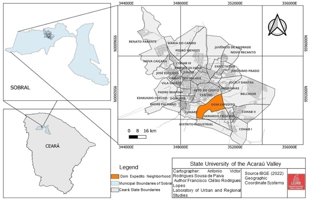
The Dom Expedito neighborhood, the object of this study, is located on the right bank of the Acaraú River (Figure 3). It has flat, sandy soil in a low-lying topography. The neighborhood has been occupied for 231 years and was once known as Várzea da Caiçara, later as Monte Castelo, and, in 1960, as Dom Expedito . It remained a segregated riverside territory due to the difficulty of crossing the Acaraú River and the lack of public investment.

The connection to the city center was made via an improvised wooden bridge, which had to be replaced after each rainy season because the river’s floods carried it away. There was overcrowding at certain times of day, so people had to wait for traffic to lessen (Carvalho; Helena, 2024). During the Acaraú River floods, transportation was carried out by canoe operators who divided the river into territories. The first boarding point was known as Gavião and was located upstream from the José Euclides Ferreira Gomes Bridge (known as the new bridge); the second is still an active route and connects the Dom Expedito neighborhood to the Nossa Senhora das Dores Church on the Left Bank; the third was downstream from the Othon de Alencar Bridge (the old bridge), near the Pedrinhas neighborhood, and was known as the Marreca point (Venâncio, 2009).
The canoeing trade was passed down within families, which behaved like guilds, since they controlled the navigable stretch, boat repair, and passage prices, in addition to canoeing. Other occupations developed along the waterway, such as washerwomen, potters, farmers, mule drivers, and vendors of drinks and food for bathers who visited the small river beaches on weekends. The neighborhood's initial population had rural origins; therefore, many retained traits of peasant life. However, the advance of urbanization and the river's integration into the city required the adoption of urban practices.
The history of the Dom Expedito neighborhood can be understood through the processes of integration and disintegration of its territory with the city, since overcoming the barrier of the Acaraú River has always been a challenge for its residents. Being closer to the city center does not necessarily mean benefiting from its centrality.
The first bridge connecting the two banks was the Othon de Alencar, built between 1932 and 1935; however, it brought little benefit to the neighborhood, since it is located on its periphery and was intended to provide greater connectivity between Sobral and the state capital, Fortaleza. The second bridge, named Dr. José Euclides, was inaugurated in 2000 and sought to “de-internalize” the neighborhood (Correio da Semana, 2000); that is, it introduced elements of urbanity, such as squares, housing complexes, a sports court, and an urban social center. In addition, Monsenhor Aloísio Pinto Avenue was opened and, together with the new bridge, connected the BR-222 highway to the Sobral Bus Terminal. The third bridge was the Martônio de Alencar cable-stayed pedestrian bridge, inaugurated in 2024, which aimed to facilitate pedestrian mobility between the two sides of the waterway and to become a new architectural landmark.
Although the Dom Expedito neighborhood had a road connection as early as the 1930s, it continued to have precarious urban infrastructure (Aguiar Júnior, 2005), with commerce limited to neighborhood life and economic activities linked to the river (Fontenelle Filho, 2015). Transformations began with the inauguration of the second bridge, which provided a new access route. Until then, residents used a wooden bridge during dry periods and, during the river’s floods, relied on canoes or on the Othon de Alencar Bridge. However, the road access increased the walking distance by about 1.5 km, since there was no bus line .
The Dr. José Euclides Bridge reduced travel time to the city center, and the neighborhood became one of Sobral’s gateways because Monsenhor Aloísio Pinto Avenue was also built. This is a 2,400-meter road axis with a bicycle lane, shoulder, and central median, which enabled a new connection with the capital of Ceará. The execution of these works required the expropriation of properties along both sides of the new road, which generated dissatisfaction due to the compensation amounts received or the need to leave the area. Of the families displaced, 38 were resettled in 40 m2 houses on lots equipped with basic infrastructure (water, electricity, and sewage services) in the Santo Antônio housing complex, located in the Sinhá Sabóia neighborhood (Canuto, 2000).
The most impactful intervention was the opening of the Terra Nova Subdivision in 2004, as it became part of the Sobral Economic Development Program (PRODECON), whose objective is to attract business ventures through the donation of land, tax exemptions, loans, and infrastructure improvements. The PRODECON lots were occupied mainly by tertiary activities - such as car dealerships, a university center, a medical-hospital center, and public facilities - with particular emphasis on a complex that includes Sobral Shopping, the Cameron Business Tower, and the Best Hotel Sobral.
Among the socio-spatial changes, we can mention the development of a new area of regional centrality, since the dealerships serve customers from across Northwestern Ceará; the increase in land prices, which rose by 22.82% between 2010 and 2019 in the vicinity of the complex, according to data from the Sobral Finance Department; and the construction of residential and commercial buildings up to 23 meters high.
The gentrification of the neighborhood does not affect it as a whole; it is concentrated near Monsenhor Aloísio Pinto Avenue and the Higher Education Institutions (HEIs) - Centro Universitário Inta and Faculdade Luciano Feijão. In the surroundings of these HEIs, there are two areas with characteristics of informal settlements, designated as Special Zones of Social Interest (ZEIS). Their residents report rising housing prices due to the ongoing expansion of HEIs and the construction of student housing.
The pressure on land became evident with the zoning assigned to the neighborhood under Law No. 60 of 2018, since 70% of the territory was classified as a Priority Occupation Zone (ZOP), that is, an area with greater construction potential, where density may reach 1,050 inhabitants/ha and building heights up to 72 meters. Under the previous legislation, density in the Maximum-Density Residential Zone (ZR4) reached 500 inhabitants/ha, covering 12.61% of the neighborhood. With the expansion of the highest-density area, the ZEIS was reduced from 196,102 m2 to 108,118 m2, meaning it fell from 17.20% to 9.48% of the territory.
The change in legislation generated demand for land and the construction of high-rise buildings aimed at a social class different from that of the current residents of Dom Expedito. The Design Home Club, developed by TGC Engenharia, is located on Monsenhor Pinto Avenue and consists of two 23-story towers with 366 units. The launch price of the apartments ranged from R$170,000 to R$700,000. It is a gentrifying complex because it features high-standard housing, an exclusive leisure area (pool, hot tub, deck, spa, coworking space, beauty area, etc.), and landscape design; thus, its residents express a desire for self-segregation.
Currently, the Design Corporate commercial tower is under construction and includes 220 office units, priced from R$214,970.00 to R$998,112.00, depending on each unit’s floor area. There is a sign in front of the development presenting it as the city’s new business center.
The analysis of gentrification in Sobral exposes the contradictions of urbanization; however, it cannot be explained in isolation, as it is a global trend. The production of space is targeted by numerous forms of capital seeking valorization, due to the high surplus-value rates compared with other sectors of the economy and the possibility of a slower capitalist circuit. Transformations considered positive and natural result from a spatial strategy in which the state mobilizes public resources to make private capital viable.
Accumulation through spatial production occurs not only by absolute geographic expansion but also through the internal differentiation of urban space. Competition forces private capital to seek advantages within the city; thus, it moves to locations with higher profit rates due to lower production costs (Harvey, 2005).
CONCLUSION
Sobral’s urban center holds the most extraordinary centrality in northwestern Ceará and has therefore been the target of real estate interests over the past twenty years. However, this is not something natural, since it received public investments and benefited from tax incentive policies aimed at attracting private enterprises. Beginning in the late twentieth century, the municipal administration adopted the global discourse of the city as a driver of development and crafted an urban image that combines history, environmentalism, and modernization.
The areas bordering the Acaraú River became the focus of urban interventions, which reinforces the global character of spatial production, as the Margem Esquerda project mimics a series of others that have redeveloped waterfronts around the world to boost the economy. In this way, the riverside neighborhoods of Centro, Dom Expedito, Pedrinhas, and Jocely Dantas transformed due to rising land prices, verticalization, the attraction of tertiary-sector developments, and changes in their residents' socioeconomic profile.
Studies on Dom Expedito reveal an exponential increase in land prices, verticalization, and the construction of consumption spaces that stimulate segregation and socio-spatial inequality, since these spaces are privately owned. In addition, the supply of spatial products beyond the area’s traditional residents' reach makes it difficult for them to remain, as urban insecurity increases alongside rising real estate pressure driven by space valorization.
The phenomenon of gentrification does not encompass the entire neighborhood, as it is concentrated in the areas that have received public and private investment - namely, the first section of Monsenhor Aloísio Pinto Avenue, the surroundings of Sobral Shopping, and the vicinity of the UNINTA and Luciano Feijão higher education institutions. These are areas that strongly attract consumers with a profile different from that of longtime residents, and that demand new housing, especially vertical condominiums. Thus, the landscape is transformed through the supply of new real estate products and the intensification of spatial inequality, since the neighborhood still contains areas with characteristics of informal settlements - Várzea Grande and Comunidade dos Gaviões.
Thus, the research revealed that the Sobral case is not an isolated phenomenon, as general determinants shape its uniqueness, i.e., the universal elements of the city's political economy, grounded in the socioeconomic formation of capitalism. To investigate gentrification in the studied neighborhood, we believe that zoning changes, with increased construction potential and reduced areas of social interest, will intensify verticalization of residential and commercial buildings, speculation over vacant lots, and pressure on the most vulnerable population.
In this sense, public policy reinforces spatial differentiation by exacerbating inequality; therefore, the role of geography as the science of differences is reaffirmed, leading to an interpretation of greater qualitative value.
ACKNOWLEDGMENTS
I thank the Ceará Foundation for Scientific and Technological Development Support (FUNCAP - Process PRH-0212-00012.01.00/23) for the financial support.
QUEBRA
DATA AVAILABILITY
Not applicable.
REFERENCES
- AGUIAR JÚNIOR, P. R. The City and the River: Production of Urban Space in Sobral, Ceará. 2005. 199 f. Dissertation (Master’s in Development and Environment) - Graduate Program in Development and Environment, Federal University of Ceará, Fortaleza, 2005.
- ALBUQUERQUE, J. L. Gated Subdivisions - New Residential Typologies in the Production of Urban Space in Sobral (CE). 2024. 259 f. Dissertation (Graduate Program in Geography) - Vale do Acaraú State University, Sobral (CE), 2024.
- BIDOU-ZACHARIASEN, C. Introduction. In: _____ (coord.). Back to the City: From Gentrification Processes to the “Revitalization” Policies of Urban Centers. São Paulo: Annablume, 2006. p. 21-54.
-
BRAZILIAN INSTITUTE OF GEOGRAPHY AND STATISTICS (IBGE). 2022 Demographic Census: Population and Households - First Results. Rio de Janeiro: IBGE, 2023. Available at: https://cidades.ibge.gov.br/brasil/ce/sobral/panorama Accessed on: July 30, 2024.
» https://cidades.ibge.gov.br/brasil/ce/sobral/panorama -
CANUTO, O. Popular Housing Program of Sobral. SANARE - Journal of Public Policies, v. 2, n. 3, pp. 46-55, 2000. Available at: https://sanare.emnuvens.com.br/sanare/index Accessed on: July 31, 2024.
» https://sanare.emnuvens.com.br/sanare/index -
CARVALHO, S.; H., T. The bridge of the late neighborhood. Jornal Correio da Semana, Feb. 10-17, 2024. Available at: https://correiodasemana.com/site Accessed on: July 31, 2024.
» https://correiodasemana.com/site - CEARÁ. Secretariat of Cities. (2018). Development of the Metropolitan Development Master Plan (PDDM) for the Sobral Metropolitan Region. Mobility Plan - preliminary version 2. Fortaleza: SCIDADES, 2018.
-
CORREIO DA SEMANA. New Bridge and New Avenue will De-Internalize the Dom Expedito Neighborhood. Correio da Semana newspaper, 5 Feb. 2000. Available at: https://correiodasemana.com/site Accessed on: July 31, 2024.
» https://correiodasemana.com/site - FERREIRA, D. L. The (Re)invention of a City: City Marketing and Urban Redevelopment in Sobral - CE. 2013. 296 f. Thesis (PhD in Social Sciences) - Institute of Philosophy and Human Sciences, State University of Campinas, Campinas/SP, 2013.
- FONTENELLE FILHO, J. Socio-Spatial Transformations in the Dom Expedito Neighborhood in Sobral/CE. 2015. 155 f. Dissertation (Master’s in Geography) - Center for Human Sciences, Vale do Acaraú State University, Sobral/CE, 2015.
- FREITAS, N. A. de. Flavors of a City: Everyday Practices of Sobral’s Inhabitants. 2005. 297 f. Thesis (PhD in Sociology) - Department of Social Sciences and Philosophy, Federal University of Ceará, Fortaleza, 2005.
- GLASS, R. Introduction to London: aspects of change. London: MacGibbon & Kee, 1964.
- GONDIM, L. M. P. The “Governments of Change” (1945-1986). In: SOUZA, S.; GONÇALVES, A. et al. (eds.). A New History of Ceará. 3rd ed. Fortaleza: Demócrito Rocha Editions, 2004. pp. 409-424.
- HARVEY, D. The New Imperialism. 2nd ed. São Paulo: Loyola, 2005.
-
HOLANDA, V. In Search of the Meanings That Pervade the Medium-Sized City. Journal of the House of Geography of Sobral, v. 2/3, n. 1, 2000/2001. Available at: https://rcgs.uvanet.br/index.php/RCGS Accessed on: Mar 30, 2024.
» https://rcgs.uvanet.br/index.php/RCGS -
JÚNIOR, M. Redevelopment of Cristo Worries Local Residents: The Renovation of the Monument in the Alto Cristo Neighborhood Aims to Enhance the Former Tourist Area. Diário do Nordeste, 10 Feb. 2018. Available at: https://diariodonordeste.verdesmares.com.br/ Accessed on: July 31, 2024.
» https://diariodonordeste.verdesmares.com.br/ - LEFEBVRE, H. Space and Politics. Belo Horizonte: UFMG, 2008.
-
LOPES, F. C. R. The Neighborhood as a Scale. GEOUSP - Space and Time (Online), São Paulo, v. 18, n. 2, pp. 288-297, 2014. Available at: https://www.revistas.usp.br/geousp/ Accessed on: Mar. 28, 2024.
» https://www.revistas.usp.br/geousp/ -
LOPES, F. C. R. Used territories in the Dom Expedito neighborhood in Sobral (CE/Brazil). Geosul, Florianópolis, v. 38, n. 88, p. 350-372, 2023. Available at: https://periodicos.ufsc.br/index.php/geosul/index Accessed on: May 9, 2024.
» https://periodicos.ufsc.br/index.php/geosul/index - PAIVA, A. V. R. de. Location of the Dom Expedito neighborhood. Sobral (CE): [s.n.], 2025. 1 map, color., 10.56 × 15 cm.
- RIGOL, S. M. Gentrification: concept and method. In: CARLOS, C. C.; CARLOS, A. F. A. (orgs.). Urbanization and globalization: studies on the metropolis. 2. ed., 1st reprint. São Paulo: Contexto, 2012. p. 98-121.
- ROCHA, H. The left side of Rio. São Paulo: Hucitec, 2003.
- SOUZA, K. R.; KERBAUY, M. T. M. Abordagem quanti-qualitativa: superação da dicotomia quantitativa-qualitativa na pesquisa em educação. Educação e Filosofia, v. 31, n. 61, p. 21-44, jan./abr. 2017.
- SOUZA, M. L. de. The fundamental concepts of socio-spatial research. 2nd ed. Rio de Janeiro: Bertrand Brasil, 2015.
- VENÂNCIO, R. Spaces of experience as spaces of memory: narratives and images among the canoeists of the Acaraú River. 2009. 148 f. Master’s dissertation (Graduate Program in Sociology) - Federal University of Ceará, Fortaleza, 2009.
- VILLAÇA, F. Intra-urban space in Brazil. 2nd ed. São Paulo: Studio Nobel; FAPESP; Lincoln Institute, 2001.
-
Editors in Charge
Alexandra Maria OliveiraAlexandre Queiroz Pereira Eduardo Von Dentz