
 Research on Ecological Restoration Planning of a Mine Area by Unmanned Aerial Vehicle Surveying and Mapping Technology
ABSTRACT
Mining has caused serious damage to the regional ecological environment. It is important to scientifically evaluate the restoration effect. This study employed a DJI Phantom 4 real-time kinematic quad-rotor unmanned aerial vehicle (UAV) to map a flux limestone mine area. Digital orthophotomaps, a digital elevation model, and a digital surface model were obtained. Vegetation coverage and water and soil loss were monitored. Data analysis found that the vegetation coverage rate in that the area was in steady growth, and the vegetation coverage rate in September 2024 was 72.49%, which was 6.37% higher than that in September 2020 and 3.15% higher than that in September 2022. The water and soil loss modulus decreased continuously, and the monitoring result in September 2020 was 2,045.92 t·km2a. It decreased to 1,221.77 t·km2a in September 2024, which decreased by 40.28% and 26.14%, respectively compared with September 2020 and September 2022. The plants in the region were mainly herbaceous plants and arbors, with rich species and a good community structure. The results verify that the implemented ecological restoration plan has been successful, and it also provides a powerful case for the promotion of UAV mapping technology in mine environmental monitoring and management.
Keywords
Unmanned aerial vehicle; Environmental surveys; Soil erosion/NDVI
INTRODUCTION
Mines provide a large number of mineral resources for human development, but long-term mining has led to large-scale exploitation of mine resources and significant damage to the ecological environment (Wan and Zhao 2021). The accumulated waste occupies a large amount of soil, leading to the decline of soil fertility and weakened function. Waste gas and wastewater generated during mining pollute the air and water sources, causing smog, sandstorms, and other problems. In serious cases, the mountain structure in the mine area may also be affected, leading to the occurrence of geological disasters such as landslides and debris flows, which pose safety risks. It is also not conducive to the long-term development of mine areas. Therefore, ecological restoration planning of mine areas is particularly important (Zhao et al. 2023). Ecological restoration planning of mine areas (Yue et al. 2022) refers to the restoration and management of the ecological environment by planting vegetation, protecting water sources, and other methods for mine areas that have been exploited, to promote the restoration of their ecological functions and achieve sustainable development. Li et al. (2023) took an abandoned coal mine in Jiangxi Province as an example to analyze the effects of four different ecological restoration modes. They found that vegetation configuration combining fruit and grass is conducive to soil and water conservation and can also produce good ecological and economic benefits. Maiti et al. (2021) analyzed the importance of plant species selection for ecological restoration. They pointed out that species that can enhance soil conservation ability should be preferred, and rooting depth, root density, and carbon sequestration potential should also be taken into account. Li and Lin (2022) put forward a landscape planning method for the stone mine park under the concept of ecological restoration to transform and upgrade the mine area, which is of great value for the restoration of the mine environment and the protection of mine relics. Unmanned aerial vehicles (UAVs) are affordable and have reliable accuracy (Syafuan et al. 2021). UAVs equipped with high-precision sensors can complete wide-range monitoring work and have good applications in many fields. Cui et al. (2023) used UAV technology to analyze soil salinization and found that the UAV-based mapping method can provide support for high-precision prediction of soil salinization during the vegetation cover period. Comert et al. (2019) used UAV-acquired data to rapidly map shallow landslides after a major landslide occurred in the Black Sea region of Turkey. They found that the accuracy of UAV-based landslide mapping was higher than 86%. UAV surveying and mapping technology can quickly and accurately complete the survey and monitoring of mine areas (Liu et al. 2019) and observe various details without time-consuming and labor-intensive manual inspection. It is a time-saving and efficient method to obtain relevant data and analyze ecological restoration planning of mine areas through UAV surveying and mapping technology. This study aims to evaluate the effectiveness of ecological restoration planning in mining areas and verify the application value of UAV mapping technology in such evaluations. Therefore, this paper took a flux limestone mine area as an example and analyzed the ecological restoration planning of the area based on data collected using UAV surveying and mapping technology. This paper aims to understand the ecological restoration situation of this mine area and provide a reference for the ecological restoration of similar mine areas. Compared with the application of existing UAVs in ecological restoration, the research in this paper obtained multi-dimensional data and made data collection more comprehensive through multiple UAV flights. It objectively evaluated the ecological restoration situation of the study area by combining vegetation coverage and the modulus of soil and water loss, providing a low-cost and replicable solution for assessing ecological restoration effects in actual mining areas.
STUDY AREA PROFILE AND UAV DATA ACQUISITION
Study area profile
Location
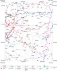
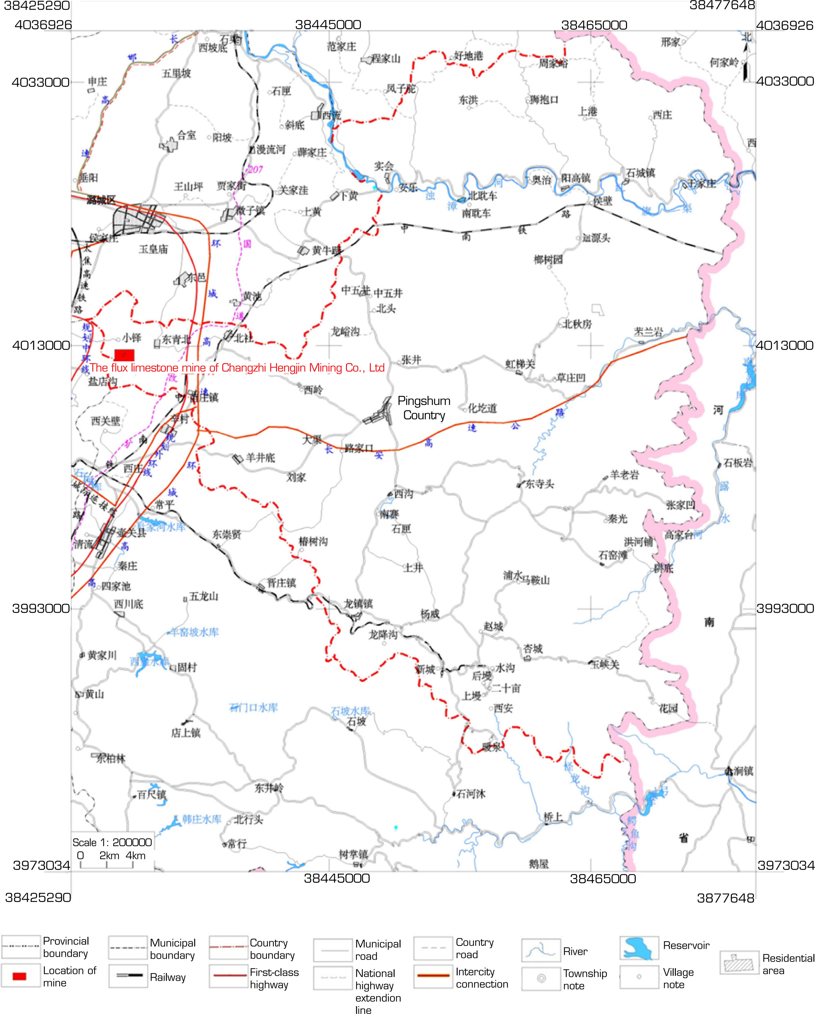
The flux limestone mine of Changzhi Hengjin Mining Co., Ltd. is located in the northwest direction of Pingshun County, 20 km away in a straight line. It falls under the administrative jurisdiction of Beishe Township, Pingshun County. Its geographical coordinates (CGCS2000 coordinate system) are 113°12'44"-113°12'53"E, and 36°14'15"-36°14'25"N. The Changzhi-Pingshun Express passes 1 km northeast of the mine area, and there is a simple path to reach the mine area (Fig. 1). The mining area was delineated by the coordinates of five inflection points in Table 1.
Geographical environment
The terrain in the mine area is generally high in the southwest and low in the northeast. The Quaternary loose overburden layer has a small range and thickness, and the bedrock in the valleys is exposed. Therefore, it is a medium and low-mountainous area. The region where the mine area is located is cold in winter with rare rain and snow, it is dry and windy in spring with frequent spring droughts, it is hot and rainy in summer, and it is mild and cool in autumn. According to the meteorological data, the average annual temperature is 8 oC. The average annual precipitation is 608 mm, and the rain is concentrated in June, July, and August. The average annual wind speed is 17.2 m·s. One hundred and seventy days are frost-free. The freezing depth is 0.63 m. This area belongs to the Zhuozhanghe River system of the Haihe River Basin. There is no surface water body in the mine area or its surrounding areas. Water for industry, agriculture, and domestic use is taken from underground by motor-pumped wells. The minimum mining elevation of the ore body is higher than the local erosion base level. The shallow groundwater in the mine area is not well developed, and the terrain is relatively steep. Agriculture is the main economic source of the mining area and its surrounding areas. The main crops are maize, millet, sorghum, and wheat.
Ecological restoration planning situation
This mining area adopted the open-pit mining method. The designed stope was mined in six benches: 1,215 m, 1,200 m, 1,185 m, 1,170 m, 1,155 m, and 1,140 m, from high to low. The bench height was 15 m. The mining technology used was medium-length hole blasting. Then, the materials were loaded by loaders and excavators and transported by dump trucks. After long-term mining, except for some undamaged original vegetation areas, there were many damaged areas caused by mining. Some of them had no vegetation growth due to occupation by factories and waste. Some were mining platforms and slopes formed by mining, which had a large distribution area and exposed rocks, and the vegetation was destroyed. Therefore, since 2018, the following measures have been taken to carry out ecological restoration planning for these damaged areas.
-
The small monomers, such as dangerous rock and pumice stone on the mining slope, were manually removed. The static crushing method was used to remove the large monomers. Active protective net reinforcement was used to anchor the dangerous rock and pumice stone that were large but had the conditions for reinforcement, to reduce the occurrence of disasters.
-
The protection of the original vegetation area and the damaged area that has shown a trend of greening was strengthened. For relatively high and steep slopes, natural greening was adopted, or climbing and hanging plants were planted to achieve coverage and greening. For gentle slopes, the method of excavation and soil cover was used to restore them to woodland.
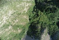
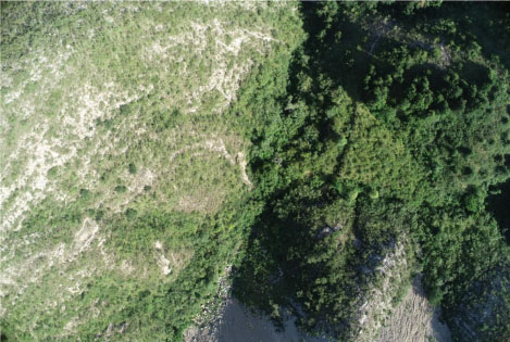
The existing greening restoration area after ecological restoration planning is shown in Fig. 2.
UAV-based data acquisition
Traditional ecological restoration planning in mine areas mostly uses manual surveying and mapping. Due to the complex terrain and high risk, especially under bad weather conditions, manual surveying and mapping are difficult and less efficient. The use of UAV surveying and mapping technology can not only greatly enhance the efficiency of surveying and mapping but also effectively avoid casualties. The comparison between manual surveying and UAV surveying is as follows.
-
Manual mapping requires a mapping team, costs more, and takes longer. The equipment used is bulky, and there is a risk of casualties.
-
UAV mapping can be carried out by one or more persons. A reusable UAV is used. Data acquisition is faster, and there is no risk of casualties.
Therefore, it is feasible to apply the UAV surveying and mapping technology in the ecological restoration planning of mine areas, and it can complete the surveying and mapping work more efficiently. In this paper, a DJI Phantom 4 real-time kinematic quad-rotor UAV was used for surveying and mapping of the research area in September 2020, September 2022, and September 2024, respectively. The weather on the acquisition days was clear, and the wind speed was low, which did not interfere with UAV data acquisition. Pix4Dcapture was used to plan the flight path (Dasari et al. 2021), and the photo overlap rate was set to 80%. To ensure the acquisition effect at different altitudes, data collection was conducted at altitudes of 120 m, 160 m, and 200 m. After the acquisition, the data were checked to ensure that there were no cases of missed flights. The images acquired by UAV were corrected and spliced using DJI Terra and then imported into Agisoft PhotoScan for processing (Jebur et al. 2020). After operations such as importing image data, aligning photos, creating a dense point cloud, generating meshes, and generating texture, the corresponding spatial 3D model was generated. On this basis, digital orthophotomaps, a digital elevation model (DEM), and a digital surface model (Qiu et al. 2024) were obtained. Agisoft PhotoScan and ArcMAP (Palanisamy et al. 2024) were used to obtain various data.
At the same time, 10 monitoring sites were selected from the study area for field investigation in September 2024 to understand the vegetation recovery situation, and data such as vegetation names and species numbers were manually recorded. Plant species on-site were initially identified and then confirmed by combining them with indoor data queries. Finally, the data were plotted in Excel.
ANALYSIS OF ECOLOGICAL RESTORATION PLANNING IN THE MINE AREA
Vegetation coverage degree analysis
Vegetation coverage degree will affect surface biomass and the situation of water and soil loss. The lower this value is, the more likely it is to cause natural disasters such as landslides and debris flows. In this paper, the normalized difference vegetation index (NDVI) (Aleksanin and Timofeev 2023) was employed to calculate the vegetation coverage degree:
where NDVIveg refers to the NDVI of the pixel with complete vegetation cover (its value is 1 in an ideal state) and NDVIsoil is the NDVI of the pixel with complete bare soil (its value is 0 in an ideal state). Due to the lack of large-area data as reference data in practice, after calculating the actual vegetation index values, a confidence level of 1% was taken. The average value of the 1% region with the smallest NDVI value was taken as NDVIsoil, and the average value of the 1% region with the largest NDVI value was taken as NDVIveg. The vegetation coverage degree was calculated in ENVI software (Pahnwar et al. 2020).
It can be seen from Table 2 that in recent years, the vegetation coverage degree of the mine mountain area has been steadily increasing. The monitoring result of the region in September 2020 was 66.12%, and that in September 2022 was 69.34%, showing an increase of 3.22% compared with September 2020. The monitoring result in September 2024 was 72.49%, which was 6.37% higher than that in September 2020 and 3.15% higher than that in September 2022. These results verified that ecological restoration planning effectively improved the vegetation cover in the study area. Through the observation of bare soil areas, it was found that most of them are high and steep landslide surfaces, which makes it difficult to provide an environment for vegetation growth, but the distribution of bare rock is relatively scattered.
Analysis of water and soil loss
In this paper, the water and soil loss modulus was calculated by referring to reference (Zhou et al. 2018) and using the universal soil loss equation (USLE) model and the InVEST-Sediment Delivery Ratio model (Sandamali et al. 2023). The USLE is:
where A is the annual soil erosion amount, R is the rainfall erosivity factor, representing the erosive force of the rainfall process, K is the soil erodibility factor, which is related to the type and organic content of soil (0.05 for sandy soil and 0.25 for clay), LS is the slope length and steepness factor, which is generated by DEM calculation, C is the vegetation coverage factor, which can be obtained from NDVI conversion, and P is the soil and water conservation measure factor (it was set as 1, as the soil and water conservation measure in the study area was not considered). The calculation formula of R is:
where n refers to the number of storm rainfall increments, i is the specific storm rainfall increment, T30 refers to the regional 30-minute storm rainfall intensity density (mm·h), Ti is the duration of a specific storm rainfall increment (h), and Ii is the rainfall intensity density of a specific storm increment (mm·h). With the support of a Geographic Information System (GIS), the above data were input into raster layers of various factors, such as DEM for raster calculations. The calculated water and soil loss modulus in the study area is presented in Table 3.
As can be seen from Table 3, water and soil loss in the study area have also been effectively improved in recent years. The monitoring result in September 2020 showed that the water and soil loss modulus in the study area was 2,045.92 t·km-2a, which decreased to 1,654.25 t·km-2a in September 2022, a decrease of 19.14%. The monitoring result in September 2024 showed that the water and soil loss modulus in the study area was 1,221.77 t·km-2a, which was reduced by 40.28% compared with September 2020 and 26.14% compared with September 2022. These results indicate that water and soil loss in this area have been effectively controlled after the implementation of ecological restoration planning.
Analysis of plant species
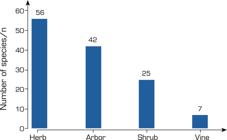
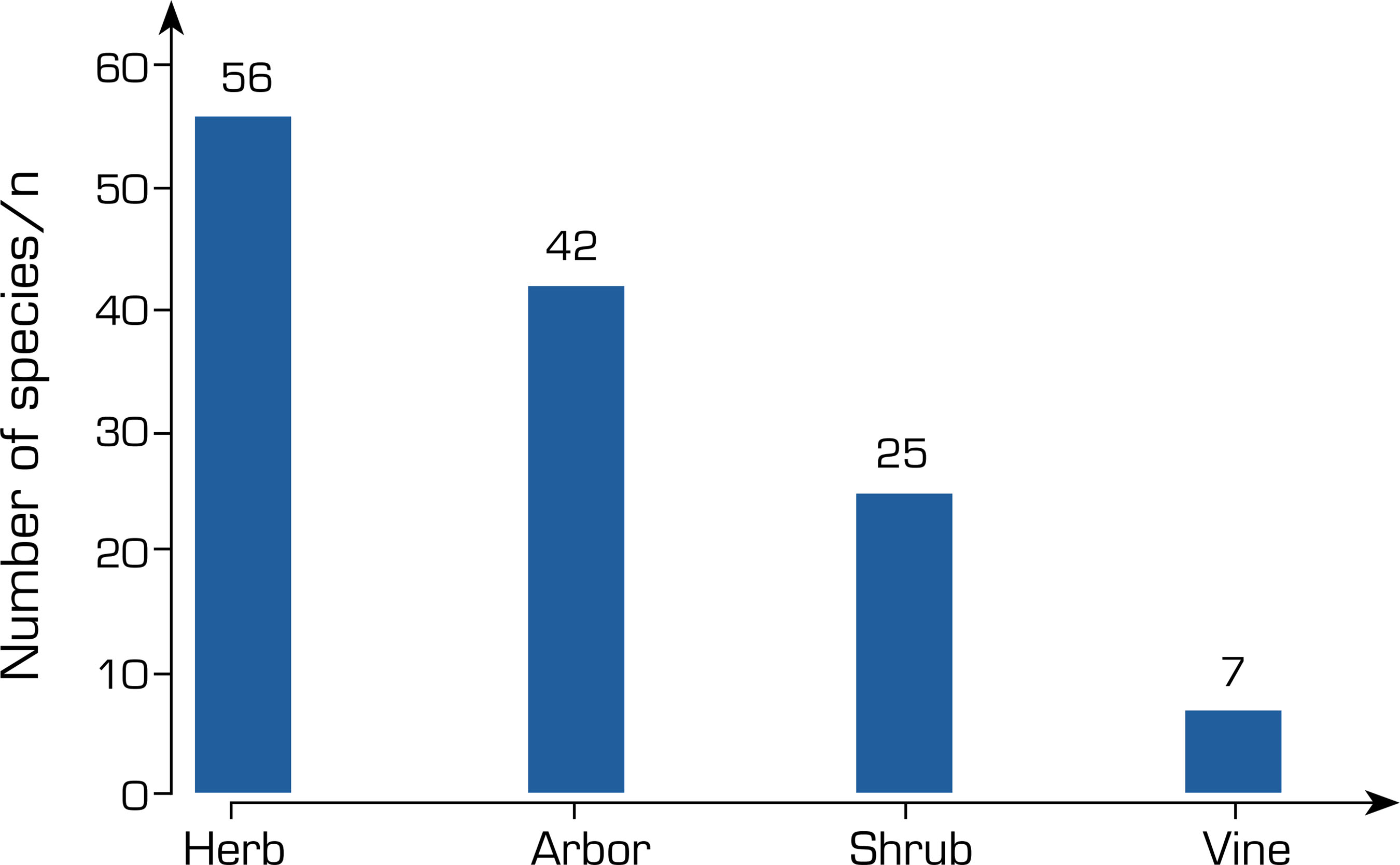
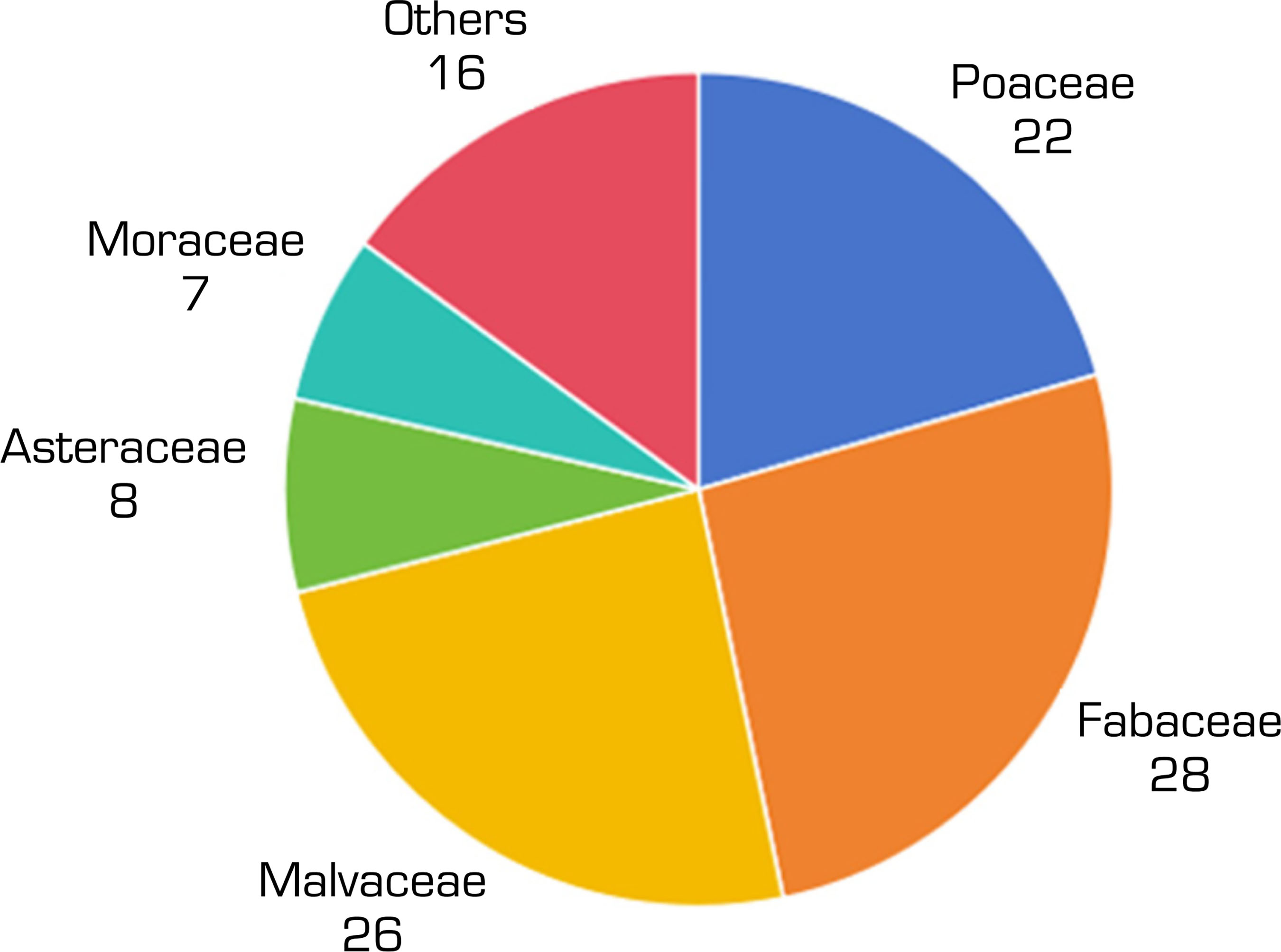
Plant species obtained from the field survey in September 2024 were counted. From Fig. 3, it can be seen that the main species in this study area were herbaceous plants and arbors, with 56 and 42 species, respectively. Moreover, there were 25 species of shrub plants, and vine plants had only seven species, the fewest. In terms of the number of species, vegetation recovery in this area is good, and many plant species have appeared. Statistics were conducted on the species families (Fig. 4).
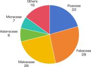
From Fig. 4, it can be found that the plants in this study area were mainly from the Leguminosae, Malvaceae, and Gramineae families, accounting for more than 50%. These plants have good effects on wind prevention and soil fixation and can promote vegetation growth. Then, there were a small number of plants from the Asteraceae, Moraceae, and other families. Generally speaking, vegetation growth and restoration in this study area were in good condition. According to the statistics of plant community structure, it was found that the community structure of the area can be divided into the following three types.
-
The type of arbor, shrub, and herb: there were 96 kinds of combinations. The arbor layer was mainly composed of Triadica cochinchinensis Lour., Pinus massoniana Lamb., and Trema tomentosa (Roxb.) H. Hara, and combined with shrubs and herbs to form the community structure.
-
Herb type: there were 22 combinations. It was the second most common community structure in this area. It was composed of Thysanolaena latifolia (Roxb. ex Hornem.) Honda, Pennisetum purpureum Schumach., and ferns.
-
Shrub type: it was mainly composed of Melastoma malabathricum L., and Heptapleurum heptaphyllum (L.) Y. F. Deng.
According to the investigation results, the community structure in this area is relatively rich, the arbors and shrubs grow well, and the community structure exhibits rich layers. However, some annual herbs have poor stability and obvious seasonal characteristics.
DISCUSSION
According to the research results, the ecological environment quality of the region has been systematically improved. The vegetation coverage rate has increased steadily, soil erosion has been effectively curbed, and the community structure has undergone positive succession, demonstrating the effectiveness of the ecological restoration planning. Specifically, the vegetation coverage rate in the study area increased from 66.12% in September 2020 to 72.49% in September 2024, verifying the continuous effectiveness of the restoration measures. Moreover, there is a certain synergistic effect between the change in vegetation coverage rate and soil erosion control. The growing vegetation canopy intercepts rainfall, reducing the source of erosion. The increasingly robust plant roots play a role in consolidating the soil and improving the soil structure, enhancing surface anti-erosion ability. In addition, the restoration project has effectively divided and isolated the easily eroded bare ground surface, preventing the connection and expansion of bare rocks and promoting the control of soil erosion.
The survey results of the plant community structure showed that the study area already has a relatively high species richness. The plant composition, mainly consisting of Leguminosae, Malvaceae, and Gramineae plants, shows good ecological rationality. Leguminous plants have the function of nitrogen fixation, which can provide nitrogen nutrition for the growth of other plants. Malvaceae and Gramineae plants have the advantages of a fast growth rate and developed root systems, which can quickly cover the ground surface, fix the soil, and protect slopes, thus accelerating the positive succession of the ecosystem. Moreover, a well-structured ecosystem prototype has taken shape in the study area. The arbor layer provides good shading conditions and changes the microclimate under the forest. The shrub layer fills the middle ecological niche, and the herbaceous layer plays a role in soil and water conservation. Different layers cooperate with each other, showing good ecological stability.
CONCLUSION
Aiming at the ecological restoration planning in the mine area, this paper used UAV surveying and mapping technology to obtain relevant data and analyzed them. The results showed that after ecological restoration planning, the vegetation coverage rate of the research area in September 2024 reached 72.49%, the water and soil loss modulus was 1,221.77 t·km2a, and the plant species in the area were also relatively rich. The community structure has a certain degree of hierarchy. These results verify the effectiveness of the current ecological restoration planning and the reliability of UAV surveying and mapping technology. The technology can be more widely applied in practice. However, the research area of this study was relatively small, and the sample size had certain limitations. In future work, this method can be used for research on mines with ecological restoration planning on a larger scale to further verify the applicability of this method.
ACKNOWLEDGEMENTS
Not applicable.
DECLARATION OF USE OF ARTIFICIAL INTELLIGENCE TOOLS
FUNDING
Peer Review History:
DATA AVAILABILITY STATEMENT
The data will be available upon request.
REFERENCES
-
Aleksanin AI, Timofeev AN (2023) The Influence of observation conditions on the accuracy of NDVI vegetation index calculation from Earth remote sensing data. Cosmic Res 20(1):133-143. https://doi.org/10.1134/S0010952523700521
» https://doi.org/10.1134/S0010952523700521 -
Comert R, Avdan U, Gorum T, Nefeslioglu HA (2019) Mapping of shallow landslides with object-based image analysis from unmanned aerial vehicle data. Eng Geol 260:1-14. https://doi.org/10.1016/j.enggeo.2019.105264
» https://doi.org/10.1016/j.enggeo.2019.105264 -
Cui X, Han W, Dong Y, Zhai X, Ma W, Zhang L, Huang S (2023) Estimating and mapping soil salinity in multiple vegetation cover periods by using unmanned aerial vehicle remote sensing. Remote Sens 15(18):4400. https://doi.org/10.3390/rs15184400
» https://doi.org/10.3390/rs15184400 -
Dasari S, Mesapam S, Kumarapu K, Mandla VR (2021) UAV in development of 3D heritage monument model: a case study of Kota Gullu, Warangal, India. J Indian Soc Remote 49(7):1733-1737. https://doi.org/10.1007/s12524-020-01250-0
» https://doi.org/10.1007/s12524-020-01250-0 -
Jebur AK, Tayeb FA, Jawad ZS (2020) Show the potential of Agisoft Photoscan software to create a 3D model for Salhiyah Residential Complex in Baghdad based on aerial photos. IOP Conf Ser: Mater Sci Eng 745(1):1-10. https://doi.org/10.1088/1757-899X/745/1/012132
» https://doi.org/10.1088/1757-899X/745/1/012132 -
Li H, Chen W, Zhang C, He L, Liang H, Li H, Liu D (2023) Effects of ecological restoration patterns on runoff and sediment in an abandoned coal mine of southern China. Environ Prot Eng 49(4):29-44. https://doi.org/10.37190/epe230402
» https://doi.org/10.37190/epe230402 -
Li J, Lin B (2022) Landscape planning of stone mine park under the concept of ecological environment restoration. Arab J Geosci 15(7):1-11. https://doi.org/10.1007/s12517-021-08893-4
» https://doi.org/10.1007/s12517-021-08893-4 -
Liu C, Zhang S, Akbar A (2019) Ground feature oriented path planning for unmanned aerial vehicle mapping. IEEE J-STARS 12(4):1175-1187. https://doi.org/10.1109/JSTARS.2019.2899369
» https://doi.org/10.1109/JSTARS.2019.2899369 -
Maiti SK, Bandyopadhyay S, Mukhopadhyay S (2021) Phytorestoration of Abandoned Mining and Oil Drilling Sites. Amsterdan: Elsevier. Chapter 14, Importance of selection of plant species for successful ecological restoration program in coal mine degraded land; 325-357. https://doi.org/10.1016/B978-0-12-821200-4.00014-5
» https://doi.org/10.1016/B978-0-12-821200-4.00014-5 -
Pahnwar V, Ullah A, Zaidi A (2020) Impact of small dams on vegetation cover in the Potohar Region of Pakistan. Paper presented 2020 IEEE International Geoscience and Remote Sensing Symposium. IEEE; Waikoloa, USA. https://doi.org/10.1109/IGARSS39084.2020.9324318
» https://doi.org/10.1109/IGARSS39084.2020.9324318 -
Palanisamy P, Sivakumar V, Velusamy P, Natarajan L (2024) Spatio-temporal analysis of shoreline changes and future forecast using remote sensing, GIS and Kalman filter model: a case study of Rio de Janeiro, Brazil. J S Am Earth Sci 133. https://doi.org/10.1016/j.jsames.2023.104701
» https://doi.org/10.1016/j.jsames.2023.104701 -
Qiu Z, Li J, Wang Y, Niu Y, Qian H (2024) automatic extraction method of landslide based on digital elevation model and digital orthophoto map data combined in complex terrain. Appl Sci (2076-3417) 14(7):2771. https://doi.org/10.3390/app14072771
» https://doi.org/10.3390/app14072771 -
Sandamali MWD, Udayakumara EPN, Baduraliya CH, Dammalage TL, Shafras MMM (2023) Soil erosion assessment with invest model: case study in Wee-Oya watershed in Sri Lanka. Asian J Microbiol Biotechnol Environ Sci 25(4):617. https://doi.org/10.53550/AJMBES.2023.v25i04.001
» https://doi.org/10.53550/AJMBES.2023.v25i04.001 -
Syafuan WM, Ismail N, Idris AN, Isa NA, Zamili FNZ, Jelani J (2021) Assessment of photogrammetric mapping accuracy in slope area with different flight altitude using unmanned aerial vehicle (UAV). IOP Conf Ser: Earth Environ Sci 767(1):012037. https://doi.org/10.1088/1755-1315/767/1/012037
» https://doi.org/10.1088/1755-1315/767/1/012037 -
Wan Y, Zhao Q (2021) Research on ecological environment protection of mining area based on Yangquan No. 3 mine. IOP Conf Ser Earth Environ Sci 781(3):1-10. https://doi.org/10.1088/1755-1315/781/3/032001
» https://doi.org/10.1088/1755-1315/781/3/032001 -
Yue YS, Luo ZY, Ji L (2022) Construction and application of monitoring index for mine ecological restoration. Bull Surv Mapping (12):136-140. https://link.oversea.cnki.net/doi/10.13474/j.cnki.11-2246.2022.0370
» https://doi.org/10.13474/j.cnki.11-2246.2022.0370 -
Zhao T, Liu Y, Deng Y, Wang G (2023) Progress and prospect of mine ecological restoration in China. J Resour Ecol 14(4):681. https://doi.org/10.5814/1674-764X-14.4.681
» https://doi.org/10.5814/1674-764X-14.4.681 -
Zhou XF, Ma GX, Cao GZ, Yu F, Zhou Y, Jia Q, Zhang YH (2018) Soil erosion change in Jiangxi Province from 2001 to 2015 based on USLE model. Bull Soil Water Conserv 38(01):8-11. https://link.oversea.cnki.net/doi/10.13961/j.cnki.stbctb.2018.01.002
» https://doi.org/10.13961/j.cnki.stbctb.2018.01.002

 Source: Retrieved from National Geographic Information Public Service Platform.
 Source: Photographed by Jiao Yurui. Huanghuashan Mountain, Pingshun County, Changzhi City, May 2024.
 Source: Elaborated by the authors.
 Source: Elaborated by the authors.