
 Class-based residential segregation in Montevideo: a census data-based approach
Abstract
The article examines class-based residential segregation in Montevideo and its metropolitan area using census data from 1996 and 2011. The population is classified according to a social class scheme that combines occupation type and occupational category. Overall segregation is measured using Moran’s I index, and LISA maps describe local patterns. Montevideo’s social classes exhibit distinct residential patterns that were already consolidated in 1996 and reaffirmed in 2011. The upper-middle class is concentrated along the southern coast and in the southeastern metropolitan area, while the working class is concentrated in peripheral areas and non-coastal metropolitan corridors. Between 1996 and 2011, working-class segregation increased, regardless of the spatial scale considered.
Keywords
residential segregation; social classes; Montevideo
Resumen
El artículo estudia la segregación residencial de clase en Montevideo y el área metropolitana usando datos censales de 1996 y 2011. Para clasificar la población se utiliza un esquema de clases que combina el tipo de ocupación y la categoría ocupacional. Para medir la segregación global se emplea el índice I de Moran y, para los patrones locales, mapas LISA. Las clases sociales montevideanas presentan patrones residenciales diferenciados, ya consolidados en 1996 y reafirmados en 2011. La clase media alta se concentra en la costa sur y el sureste metropolitano; la clase trabajadora se concentra en zonas periféricas y ejes metropolitanos no costeros. Entre 1996 y 2011, la segregación de la clase trabajadora aumentó, independientemente de la escala espacial considerada.
Palabras clave
segregación residencial; clases sociales; Montevideo
Introduction
Since the mid-twentieth century, Latin American cities have experienced rapid urbanization, driven by intense rural-to-urban migration associated with early industrialization (Jaramillo, 2021). This process unfolded in a context of slow economic growth, the persistence of non-capitalist activities, and a weakened state apparatus. These conditions further entrenched historically unequal socio-economic and spatial structures. In socio-spatial terms, this has manifested in a segregated residential structure, marked by the peripheralization of the working classes and their physical and social distancing from middle- and upper-income groups (Ciccolella, 2011).
In the 1990s, amid deindustrialization and neoliberal reforms, the morphology of Latin American metropolitan areas underwent significant reconfiguration. The development of new residential projects outside the city, along with the construction of intra-urban highways that accelerated transit between peripheries and central areas, rendered peripheral zones increasingly attractive to upper-income groups (Borsdorf, 2003), thus triggering what some authors describe as elite metropolization (Torres, 1998; Rufí, 2003).
Elite metropolization has been accompanied by a simultaneous expansion of low-income peripheries. Among several contributing factors, two processes stand out. On the one hand, an incipient wave of revitalization in central and near-central areas, after decades of decline and abandonment, has once again attracted upper-middle sectors. This trend has put pressure on middle classes already weakened by successive crises, as well as on low-income residents still living in these areas, ultimately displacing many of them (Blanco & Apaolaza, 2016). On the other hand, the densification of consolidated informal settlements has also contributed to the expansion of low-income peripheries and the emergence of so-called “super-peripheries” (Abramo, 2012, p, p. 51).
The dawn of the twenty-first century finds Latin American cities with socio-economic and spatial structures that reflect a renewed intensification of inequality and residential segregation (Segura, 2014). These structures present new features distinct from those inherited from the developmentalist-industrial crisis. The urban structure, previously dual, has shifted toward a fragmented one, where social housing, informal settlements, gated enclaves, and upscale real estate developments coexist on the urban periphery (Janoschka, 2002). In light of these transformations, Prévôt notes that “It is advisable to replace the dual reading of urban space with that of a dissociated segregation (…) This ‘fractal’ property of inequity phenomena explains the growth of inequalities within the same territories” (Prévôt, 2001, p. 48).
According to much of the existing literature, new patterns of socio-spatial differentiation have emerged, characterized by a reduction in the spatial scale of residential segregation. This results from the juxtaposition, at a small scale, of low-income groups that have inhabited the peripheries for decades with high-income strata that have recently arrived (Sabatini et al., 2001; Buzai, 2014). Other studies, however, challenge this view, noting that “segregation may not have decreased in scale, but rather increased and expanded territorially through luxury lots and gated communities; that is, both in isolated and continuous forms” (Ruiz- -Tagle & López Morales, 2014).
The description of residential segregation processes presented in the preceding paragraphs generalizes certain patterns, primarily based on the analysis of large Latin American cities. This perspective draws on the tradition of urban studies in the region, which, using cities such as Lima, Buenos Aires, São Paulo, Santiago de Chile, and Mexico City as empirical references, has generalized urbanization patterns across the continent (Segura, 2021). Moreover, urban sociology has long emphasized that residential segregation was a phenomenon specific to large cities, which justified their centrality in urban research (Rodríguez & Palumbo, 2025).
However, a renewed urban research agenda has recently promoted specific studies on residential segregation in medium-sized cities (Molinatti, 2013; Araujo & Queiroz Filho, 2018), as well as compilations of comparative work, aiming to recover the Latin American dimension of the urban debate (Freire- -Medeiros & O’Donnell, 2018). This effort to broaden the perspective on urban processes, by incorporating cities that have received little attention in the literature while maintaining dialogue with regional antecedents, provides the framework within which this article is situated.
Case study: the “exceptionalism” of Montevideo
Within the regional context, Montevideo has often been described as an exception, a compact and integrated urban area shaped by early urbanization. However, while the city’s urban structure may not display the stark contrasts seen in other Latin American metropolises, it is far from egalitarian. Historically, Montevideo has been marked by a strong socio-economic division of space. National research has highlighted processes of socio-spatial differentiation at least since the 1940s, when the first irregular settlements, popularly known as cantegriles, began to emerge (Bolaña, 2018).
During the authoritarian regime of the 1970s and the early 1980s, social inequality deepened (Benton, 1986; Portes, 1989), gradually translating into spatial patterns (Mazzei & Veiga, 1985). As Kaztman, Filgueira, and Errandonea (2008, p. 370) note: “The crisis of the import-substitution model and the shift to liberal economic policies (…) contributed to reshaping both the social structure and composition of classes, as well as their spatial distribution within the city.”
In the 1990s, irregular settlements expanded, first in Montevideo’s periphery and later along the main non-coastal national routes providing access to the city. Upper-income groups, in turn, began to concentrate along the coastal area and subsequently to settle in the first gated communities (Álvarez Rivadulla, 2007; Pérez Sánchez, 2023). Likewise, the territorial development and population growth of the coastal metropolitan area stand out, in the context of an incipient suburbanization of upper-middle and high-income sectors (Artigas et al., 2002).
By the early 2000s, Montevideo has a residentially segregated urban structure, which was further aggravated by the 2002 economic crisis, the most severe in the country’s history (Boado & Fernández, 2005; Álvarez Rivadulla, 2019). From the second half of the 2000s, Uruguay began a recovery process, framed by a favorable international context and changes in social policy and labor legislation following the inauguration of the first progressive government in 2005. Overall income inequality decreased, resulting in the city’s reclassification in the UN-Habitat (2016) index, from relative to moderate inequality.
Nevertheless, the national literature emphasizes that, even in contexts of declining overall inequality, economic residential segregation has persisted and, depending on the classification criteria and spatial scale considered, has even increased (Aguiar, 2016; Serna & González, 2017; Rubini, 2020), suggesting a decoupling between income distribution and patterns of socio-spatial differentiation (Segura, 2014).
This article aims to contribute to the analysis of changes and continuities in economic residential segregation patterns in Montevideo. The city represents a relevant case for study, allowing for a test of the assumption that residential segregation intensifies even in contexts of declining inequality, in a city considered, at least in comparative studies, as relatively integrated.
The study also takes into account two aspects that have received relatively little attention in the national literature. First, most studies on residential segregation in Montevideo have confined their analysis to the city’s administrative boundaries (Kaztman & Retamoso, 2005, 2007; Aguiar, 2016; Serna & González, 2017). Considering the processes of metropolitan expansion experienced since the 1990s (Artigas et al., 2002), this article examines both the city of Montevideo and its metropolitan area. Second, national studies have primarily used economic or educational outcomes as the population classification criterion in segregation studies. Drawing on the rich sociological tradition of class stratification studies, this article analyzes segregation with a focus on residential class patterns.
Residential segregation and social class
The social division of space has distinguished cities since their origins and, as such, it can be argued that segregation is constitutive of urban life. The term originated in nineteenth-century genetics; in the early twentieth century, the Chicago School drew explanatory inspiration from analogies with the plant kingdom, and the concept was adopted as a metaphor for the residential separation of groups (Park, 1957), remaining the dominant understanding of segregation to this day.
Although residential segregation, understood as the spatial separation of social groups based on their place of residence (Sabatini et al., 2001), may appear to be a simple and decontextualized concept, it is in fact deeply intertwined with various social phenomena, particularly economic inequality. On one hand, segregation is shaped by inequality through residential sorting mechanisms. At the same time, segregation contributes to the production and reproduction of inequality. It does so by either restricting or enhancing the opportunities available to individuals and communities across multiple dimensions, most notably income, access to employment, and education, as highlighted in the literature. As a dynamic process, Arriagada and Rodríguez (2003, p. 6) note, “segregation functions as a mechanism for reproducing socioeconomic inequalities, of which it is itself a manifestation.”
A main issue in segregation analysis is how the population is classified in order to assess the phenomenon. The foundational Anglo-American tradition has focused primarily on ethnoracial groups. This focus stems from the legacy of slavery and the large waves of immigration in the early twentieth century, both regulated through institutionalized discrimination, including residential segregation (Massey & Denton, 1988, 1993).
However, as noted by Maloutas and Fujita (2012), the distinctive feature in capitalist societies lies in the fact that segregation results mainly from economic mechanisms. These operate through housing markets and are driven by households’ unequal ability to pay, rather than by other forms of social violence. In the Latin American context, land prices have historically shaped the social division of space. As a result, residential segregation has been addressed primarily through socioeconomic criteria (Segura, 2014)
Socioeconomic residential segregation has been analyzed both internationally (Van Ham et al., 2021) and regionally, mainly using outcome indicators to classify the population. These indicators include income strata (Sabatini et al., 2001), poverty status (Kaztman & Retamoso, 2005), housing conditions (Niembro et al., 2019), and educational attainment (Kaztman & Retamoso, 2007). While these indicators are undoubtedly relevant for understanding the phenomenon, sociology has developed a rich tradition of analysis of social stratification through class schemes and occupational position (Torrado, 1992; Erikson & Goldthorpe, 1992; Wright, 1995). With some exceptions (Link et al., 2015), this perspective has largely been overlooked in studies on residential segregation (Ruiz-Tagle & López Morales, 2014).
This article proposes to address segregation by examining the separation of social classes according to their place of residence. It starts from a class concept defined in terms of the structured social relationships that classes establish with one another. Unlike outcome-focused studies, which assess how equal or unequal the distribution of an attribute is (income, housing conditions, education), the relational-class approach considers the interdependent relationships between social classes, which produce and reproduce unequal distributions. From this perspective, inequality and residential segregation cannot be understood by looking at groups in isolation (the poor, those with inadequate housing, or those with low educational attainment). Instead, the analysis must consider the entire urban socio- -spatial structure (Boado & Vanoli, 2023).
Social classes operate as a classification system, allowing differences between social groups in terms of life chances. This generates unequal access to economic godos. According to Di Virgilio & Heredia (Di Virgilio & Heredia, 2012, p. 5).
The class structure can be understood as a (unequal) distribution structure of opportunities that varies over time and space. […] Environmental characteristics and their spatial location condition the probabilities of access to goods, services, and activities, introducing variations in inhabitants’ access to opportunities.
The residential class segregation approach is not new. Since the 1970s, Marxist urban sociology has proposed understanding segregation as a phenomenon linked to class structure, mediated by capitalist logic and, in particular, by urban land rent. From this perspective, segregation reflects the distribution of residential locations according to individuals’ social capacity, that is, in capitalist societies, according to income and occupational status (Link et al., 2015).
Following Ruiz-Tagle and López Morales’ approach (2014), class schemes for studying residential segregation are understood to have an advantage over widely used income-based classification criteria: they can account for identity-stable groups over time. In particular, as recent studies on the Uruguayan case have shown, social stratification measured by income and occupational position presents a low correlation. The expansion of consumption in the first two decades of the 21st century has led to the growth of the middle class in terms of income-based position gradients, but it has not changed the occupational structure. This challenges the notion of a mesocratic society, given the situational fragility of this development (Álvarez Rivadulla et al., 2022)
Regarding residential classification based on educational attainment, another widely used criterion for studying segregation, Ruiz- -Tagle and López Morales (2014) point out that it does not establish a fixed boundary over time. Having certain educational credentials today is not the same as having had them in the past, and achieving them does not necessarily imply social mobility. Additionally, classifications based on attained education often do not account for individuals’ ages, overlooking the evolution of educational achievements and the social effects they may have in different historical contexts.
In short, particularly for the longitudinal analysis of socioeconomic residential segregation proposed in this article, relying on economic or educational criteria could lead to imprecise interpretations of the phenomenon’s evolution. In contrast, residential class segregation tends to show lower elasticity, making it a consistent classification criterion over time. Additionally, as Ribeiro (2003, p. 97) notes
Socio-occupational classification allows for distinguishing individuals’ spatial location as a result of resource possession, orientations or preferences, and constraints. This criterion plays a unifying role among the multiple dimensions involved in the distribution of people across urban space.
Methodology
Spatial Residential Segregation Measurement
From its publication in 1955 until the mid-1970s, residential segregation measurement was carried out almost exclusively using Duncan and Duncan’s dissimilarity index (1955). The index ranges from 0 to 1 and conceptually represents the proportion of the minority social group that would need to move within the city to achieve an equal population distribution. In 1988, Massey and Denton proposed the joint use of five indices to measure what they considered the five dimensions of segregation: evenness, exposure, concentration, centralization, and clustering. Their proposal was well received and remained prevalent in the literature for nearly two decades.
However, the usefulness of these measures for capturing the spatial dimension of residential segregation has been increasingly questioned. It is argued that segregation measures must incorporate geographic information about spatial adjacency between units in their calculation in order to properly account for space (Wong, 2013). Otherwise, at least three major issues may arise: (a) the inability to distinguish spatial segregation patterns, (b) the inability to assess the statistical significance of the estimates, and (c) the inability to identify local residential segregation patterns (Garrocho & Campos-Alanís, 2013).
In response to these concerns, the use of spatial indicators of residential segregation has become increasingly widespread. Among them, Moran’s I, both in its global and local forms, has been one of the most commonly used (Kaztman & Retamoso, 2005; Aguiar, 2016; Palumbo, 2023; De Falco & Irpino, 2024). This article applies it to quantify segregation and identify local patterns of the phenomenon.
Moran’s I is a spatial autocorrelation indicator. It measures the property of a variable (in this article, class categories) to take on values, in pairs of observations separated by a certain distance, that are more similar (positive autocorrelation) or less similar (negative autocorrelation) than would be expected under a random distribution of pairs. Positive spatial autocorrelation indicates the clustering of spatial units with similar characteristics—one of the five dimensions of residential segregation proposed by Massey and Denton (1988).
Moran’s I has three key attributes that allow it to overcome the limitations of non-spatial segregation indicators, namely:
a) It allows for distinguishing spatial segregation patterns by incorporating neighborhood criteria into its calculation. Spatial autocorrelation refers to the similarity (or dissimilarity) of a variable’s values across neighboring spatial units. So, a preliminary step is to define which units are considered neighbors. There are two main approaches to establishing the neighborhood structure of a dataset: one based on a distance function between observation pairs, and another based on contiguity criteria. The latter may define neighbors as units that share edges (rook criterion), vertices (bishop criterion), or both (queen criterion).
b)The neighborhood structure can be formally represented in a contiguity matrix, where each spatial unit corresponds to a row and a column. In each row, nonzero values indicate neighboring units. This allows linking, through a spatial lag operator, the value of a variable in one spatial unit with the values of that variable in other neighboring units (Anselin, 1988).
Moran’s I is computed based on the cross-product of a variable and the weighted average of that variable’s values in neighboring spatial units, expressed as deviations from the mean. For an observation at point i, this is expressed as , where is the mean of the variable x
Moran’s I can be expressed as:
Where wij is the spatial weight matrix, is the sum of all weights, and n is the number of observations.
c) It allows for assessing the statistical significance of the analysis using the permutation method. Inference for Moran’s I is based on the null hypothesis of a spatially random distribution of observations. The statistical distribution under this random distribution condition is derived computationally through permutations, from which a pseudo p-value is calculated as:
Where R is the number of Moran’s I calculations on the randomly generated dataset, and M is the number of permutations (usually 99, 999, 9,999, or more) (Anselin, 2005).
d) It allows for identifying local patterns of residential segregation through the local variant of Moran’s I, the Local Indicators of Spatial Association (LISA). The LISA indicator decomposes Moran’s I into contributions from each individual observation, assigning a statistical significance level to the cluster of observations surrounding each unit. The LISA map identifies spatial units where the null hypothesis of a random spatial distribution is not rejected and classifies them as: (a) spatial units with positive autocorrelation (high-high and low-low) and (b) spatial units with negative spatial autocorrelation, or outliers (high-low or low-high). The former reflect local patterns of segregation, while the latter indicate outliers, illustrative of fragmentation scenarios.
Social class ccheme
In order to measure social classes, an adaptation of the class scheme proposed by Torrado (1992) is used. Torrado’s socio-occupational scheme, widely cited in the Latin American literature, offers the advantages of flexibility and being designed for application in official records such as household surveys and population censuses. This proposal is based on a relational conception of social classes and operationalizes it through five variables: activity status, type and category of occupation, branch of economic activity, and establishment size.
Torrado’s adapted scheme, applied in this article to the 1996 and 2011 Population Censuses, builds on the statistical data harmonization work carried out by Boado and Vanoli (2023). It considers two variables: occupation type (International Standard Classification of Occupations at the two-digit level, developed by the International Labour Organization) and occupational category (employer, employee, self-employed, and unpaid family worker). The result is a scheme of eight social classes.
For the purposes of this article, and following previous studies (Pla, 2013), the eight categories are grouped as shown in Chart 1. The analysis of residential class segregation will consider the proportion of the upper-middle class and the working class within the total employed population in Montevideo and the metropolitan area.
Spatial scale and the modifiable areal unit problem
The study area in this article includes the city of Montevideo and its metropolitan area, defined as the sum of all urban localities (towns and cities) within a 30 km radius from Montevideo’s kilometer zero, excluding rural areas. In previous national studies, two spatial scales have been prioritized to assess socioeconomic residential segregation: neighborhoods and census tracts. As noted by Kaztman and Retamoso, “In the case of Montevideo, (…) both neighborhoods and census tracts have proven to be relevant contexts for interpreting residents’ behavior” (Kaztman & Retamoso, 2005, p. 19).
Neighborhoods, defined by functional identity, represent a meaningful boundary within Montevideo’s urban social structure and are officially recognized by the National Institute of Statistics (Aguiar, 2016).
Census tracts, although based on arbitrary boundaries drawn for geostatistical purposes, offer a smaller-scale unit of analysis. Their use allows for testing both the hypothesis of decreasing spatial scale in segregation and the broader thesis of socio-spatial fragmentation.
However, this article faces an additional challenge in defining the spatial scale. While neighborhoods have proven to be a relevant unit of spatial analysis in national urban studies, this subdivision applies only to Montevideo. There is no official neighborhood-level division that can be extended to the metropolitan area.
Nevertheless, in demographic terms, as well as in relation to functional identity and their role in shaping the metropolitan social structure, the towns and cities within the metropolitan area can be considered equivalent to Montevideo’s neighborhoods.
Based on the above, this article uses two spatial scales in a complementary way. The first includes Montevideo’s neighborhoods and metropolitan urban towns and cities, combined into a single universe of 116 spatial analysis units. The second scale refers to census tracts—geostatistical units defined by population criteria in urban areas—comprising a total of 1.292 spatial analysis units.
Figure 1 shows the location of Uruguay and Montevideo within the South American context, and illustrates the study area along with the spatial scales considered.

– Maps of (a) South America; (b) Montevideo and the metropolitan area subdivided into neighborhoods and metropolitan towns and cities; and (c) Montevideo and the metropolitan area subdivided into census tracts
The methodological treatment of spatial scale inevitably involves the Modifiable Areal Unit Problem (MAUP), which highlights the sensitivity of statistical results to how space is subdivided. This includes both aggregation decisions (the scale problem) and the shape of the spatial unit or zoning criteria adopted (the zoning problem) (Fotheringham & Wong, 1991).
Rodríguez (2016) shows that in residential segregation analysis, statistical estimates are sensitive to the spatial scale applied: the smaller the spatial unit, the higher the levels of segregation tend to be.
The above calls for caution in drawing conclusions, without disregarding the analytical relevance of the spatial scales used. To test the robustness of the findings, this study systematically compares the results, assessing the consistency of the indicators under different spatial weighting criteria.
Data sources
The article uses the 1996 and 2011 National Census of Housing, Households, and Population as its primary data source. The 1996 Census recorded a total population of 3.163.763, of whom 607,116 lived in Montevideo and its metropolitan area and were employed. The 2011 Census recorded a total population of 3.286.314, with 749.600 living in Montevideo and its metropolitan area and employed. Both datasets constitute the study universe. Members of the Armed Forces and agricultural producers and workers are excluded from this universe.
Despite the advantages of using census data for segregation studies, undercounting introduces a potential bias, estimated at around 4% for the 1996 and 2011 Censuses (INE, 2009, 2012). Moreover, the undercount is not spatially random but higher in areas with lower socioeconomic status (Riaño, 2019), which could lead to an underestimation of working-class residential segregatio.
Results
Urban Social Structure of Montevideo and the Metropolitan Area, 1996-2011
Montevideo and its metropolitan area form a relatively contiguous urban conglomerate, extending within a 30-kilometer radius around the city center. During the last decade of the 20th century and the first decade of the 21st, Montevideo experienced, like other Latin American metropolises (Borsdorf, 2003; Rufí, 2003; Blanco & Apaolaza, 2016), a sustained expansion of its metropolitan area, accompanied by a population loss in the central city. Montevideo and its metropolitan area form a relatively contiguous urban conglomerate, extending within a 30-kilometer radius around the city center. This urban conglomerate grew from 1.601.663 inhabitants in 1996 to 1.653.128 in 2011, representing a relative increase of 3%. Growth was driven by the metropolitan area (19%), which offset stagnation in the central city proper (Table 1).
Uruguay, particularly Montevideo, has traditionally been considered a mesocratic society (Álvarez Rivadulla et al., 2022), a condition largely supported by the weight of the public sector and formal urban employment. In the last decades of the 20th century, this image was undermined by liberal reforms aimed at reducing the role of the state, as well as by successive economic crises that affected the purchasing power of the middle strata (Kaztman et al., 2008).
Since the early 2000s, the combination of economic growth and social reforms led to improved income levels among the population, fueling expectations of a middle- -class resurgence. However, relational analyses based on occupational positions show that these transformations did not result in changes to the class structure. As Álvarez Rivadulla et al. (2022, p. 55) point out, “no significant changes are observed in the occupational structure, nor an increase in occupations that are typically considered middle class.”
Torrado’s (1992) class scheme application to Montevideo and its metropolitan area reveals a class structure that has remained largely stable over time (Table 2). Approximately half of the employed population in this urban area belongs to the middle class, which includes technicians, teachers, sales workers, and skilled manual laborers. Just over 40% fall within the working class, comprising both skilled and unskilled manual workers. The upper-middle class, composed of business executives, high-ranking public officials, specialized professionals (such as engineers, doctors, dentists, pharmacists, economists, accountants, lawyers, architects, and related occupations), and small business owners, accounts for less than 10%.
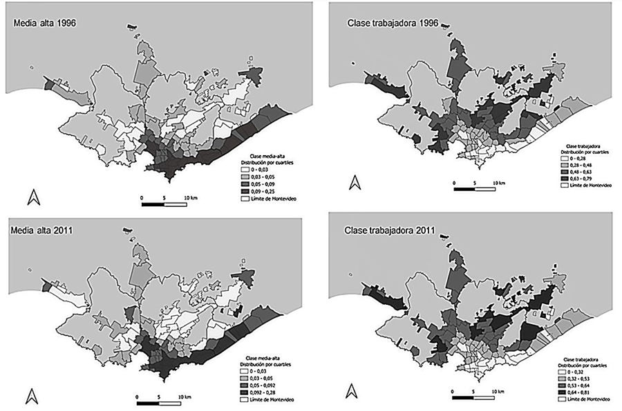
Despite the stability of the class structure, Montevideo has experienced a gradual increase in the physical separation between social classes since the late 20th century (Kaztman et al., 2008). By 1996, the spatial distribution of social classes revealed stark contrasts. An upper-middle-class corridor extended in an “L” shape from the city center to the southeast, reaching southern metropolitan localities (Figure 2, top left map). In contrast, a working-class neighborhood ring stretched from the west to the northeast, encompassing peripheral neighborhoods and non-coastal metropolitan towns along Routes 1, 5, and 8 (Figure 2, top right map). By 2011, following more than five years of economic recovery and an overall reduction in inequality, this spatial pattern remained largely unchanged (Figure 2, bottom left and right maps), highlighting the decoupling between income inequality evolution and the spatial differentiation of class (Segura, 2014).
– Montevideo neighborhoods and metropolitan towns and cities social class map, 1996 and 2011
Therefore, the analysis of the spatial distribution of social classes at the neighborhood and metropolitan locality levels suggests that, by 1996, Montevideo and its metropolitan area formed a dual-morphology urban conglomerate, characterized by clear socio-spatial class stratification. This pattern remained largely unchanged by 2011. Such social maps indicate economically segregated urban structures, as shown in national studies for Montevideo, using population classification based on economic and educational outcomes (Kaztman & Retamoso, 2005, 2007; Aguiar, 2016; Serna & González, 2017; Rubini, 2020).
Class-based residential segregation trends in Montevideo and its metropolitan area
This section focuses on the analysis of class-based socio-spatial differentiation in Montevideo and its metropolitan area, examining both changes and continuities in residential segregation between 1996 and 2011. The analysis draws on global indicators of spatial autocorrelation to assess overall levels of economic segregation, and on local indicators of spatial association to identify localized segregation patterns.
In light of the transformations observed in Latin American cities, particularly the reduction in the spatial scale of residential segregation (Sabatini et al., 2001; Buzai, 2014), this study analyzes class-based residential segregation using two spatial units. The analysis aims to assess the robustness of the results under different territorial subdivision criteria by comparing segregation patterns across two levels: (a) neighborhoods in Montevideo and metropolitan cities and towns, and (b) census tracts.
Table 3 presents the Moran’s I values for the spatial distribution of the relative share of the upper-middle and working classes in 1996 and 2011, using three different spatial weighting criteria. The first key finding is that, regardless of the spatial weight matrix applied, the null hypothesis of a random spatial distribution of social class proportions is rejected in both years and across both spatial scales.
The modifiable areal unit problem calls for caution when comparing results across spatial scales. Moran’s I values are consistently higher at the census tract scale than at the neighborhood scale. This does not, by itself, indicate higher levels of residential segregation at the finer scale; rather, it reflects changes in the statistic due to the increased level of disaggregation (Rodríguez, 2016).
The results are robust regarding the direction of spatial autocorrelation: in all cases, it is positive, indicating a tendency for neighborhoods and census tracts with similar class structures to cluster spatially. Massey and Denton (1988) identify clustering as one of the dimensions of residential segregation, characterized by the spatial grouping of social classes and the formation of homogeneous social enclaves. This phenomenon has been extensively documented in the literature (Kaztman & Retamoso, 2005; Aguiar, 2016; Palumbo, 2023; De Falco & Irpino, 2024).
The longitudinal analysis reveals divergent trends in the evolution of class-based residential segregation. For the upper-middle class, segregation levels at the neighborhood and metropolitan city scale decrease between 1996 and 2011 across all three spatial weighting criteria. In contrast, at the census tract scale, Moran’s I values remain virtually unchanged. Overall, during the study period, self-segregation among the upper-middle sectors does not intensify. Conversely, residential segregation of the working class increases between 1996 and 2011. These results are robust across both spatial scales and all three spatial weighting criteria.
Structural adjustment processes, economic liberalization, and labor market restructuring—marked by deindustrialization and a shift toward services during the last decade of the 20th century—particularly affected the working class, as reflected in the spatial classification system (Kaztman; Filgueira; Errandonea, 2008; Di Virgilio & Heredia, 2012). These structural transformations, which led to an increase in residential segregation of the working class by the end of the 20th century, were not reversed in the first decade of the 21st century. Despite relative improvements in income and consumption among middle- and lower-income groups, class stratification persisted (Álvarez Rivadulla et al., 2022), and the working class tended to reside in socially homogeneous, segregated neighborhoods.
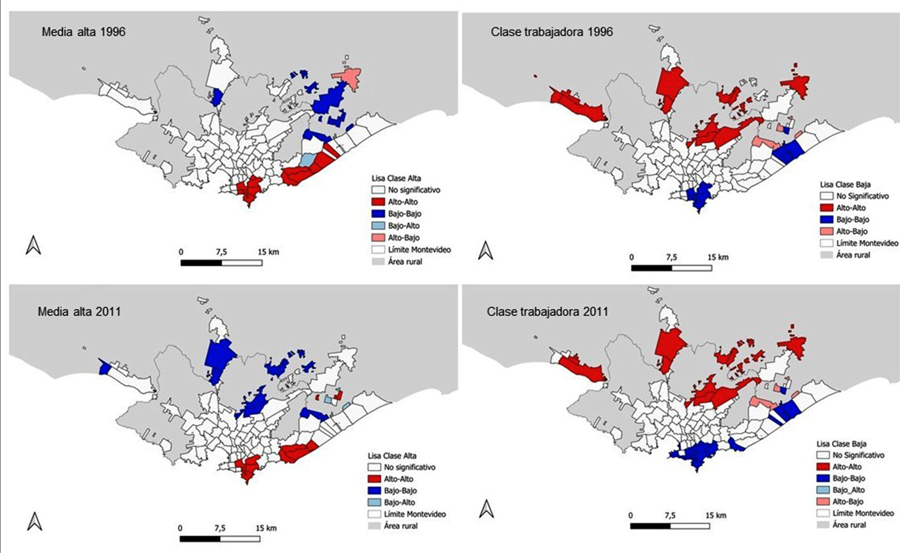
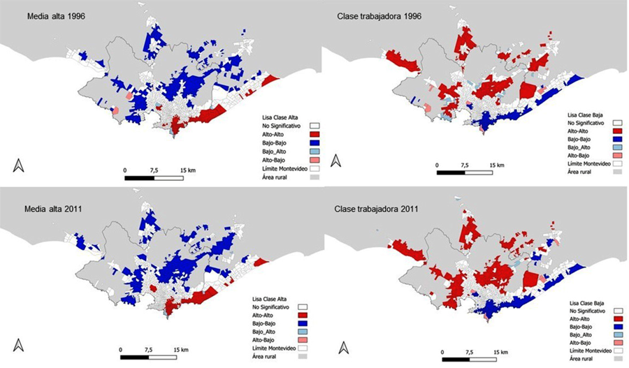
Global spatial autocorrelation is useful for assessing citywide segregation levels. However, these overall segregation patterns manifest themselves through local specificities that can be explored using local spatial autocorrelation maps (Figures 3 and 4). These maps display clusters of spatial units with homogeneously high (in red) or low (in blue) values in a given variable of interest (in this case, upper-middle- -class and working-class populations), as well as outlier units with high or low values surrounded by neighboring units with opposite levels (in pink and light blue, respectively).
Although there is a tendency for neighborhoods with similar class compositions to cluster, a first aspect to highlight across both spatial scales is that, in large parts of Montevideo and the surrounding metropolitan area, the null hypothesis of random distribution cannot be rejected. These areas, shown in white on the maps, suggest a degree of social mixing. In other words, class-based residential segregation is not uniformly expressed throughout the city.
Regarding the spatial patterns of upper-middle-class residential segregation, two clusters can be observed along the southern and southeastern coastal areas, both in 1996 and 2011 (Figure 3, top right and bottom left maps). In 2011, two small additional clusters appear in the northeast, corresponding to areas with new gated communities. Nearby, a low-high outlier (shown in light blue) illustrates local-scale patterns of residential class segregation (Sabatini et al., 2001; Buzai, 2014). In contrast, particularly in the northern and northeastern metropolitan periphery, homogeneous clusters of towns and cities with low upper-middle-class presence are observed (shown in blue).

Spatial scale reduction confirms the tendency toward the formation of a cluster of spatial units with a consistently high concentration of upper-middle-class population, extending relatively continuously along the southern and southeastern coastline. Smaller clusters also emerge along the coastal segments of the inter-resort metropolitan corridor. A broad area of peripheral census tracts, where upper- -middle-class presence remains consistently low, completes the map.
Working-class residential segregation patterns show the opposite trend to those of the upper-middle class. At the neighborhood level, a cluster with consistently high values is identified in the northern periphery, along with additional clusters along the non-coastal metropolitan corridors. These clusters expanded northeastward by 2011 (Figure 3, bottom right map). The analysis at the census tract level confirms the peripheral pattern of working-class residential segregation. A high-high positive autocorrelation cluster forms a ring around Montevideo and extends continuously along the non-coastal metropolitan corridors.
The longitudinal analysis shows an expansion of the red cluster, illustrating the intensification of working-class residential segregation (Figure 4, top right and bottom right maps), and pointing to the persistence of the peripheralization process. This trend aligns with findings reported for other cities in the region (Abramo, 2012).

At both the neighborhood and census tract levels, some outlier situations can be observed. In both 1996 and 2011, certain spatial units in the northeastern metropolitan area display unusually high concentrations of working--class populations (shown in pink), surrounded by areas with contrasting characteristics. These patterns may point to urban fragmentation or inequality within the same territory (Prévôt, 2001; Janoschka, 2002), partially challenging the dual-city image suggested thus far in the analysis. The findings also align with the expansion of gated communities in the northeastern metropolitan area (Álvarez Rivadulla, 2007; Pérez Sánchez, 2023).
Conclusions
In the last decades of the 20th century, Latin American cities experienced a deepening of residential segregation and transformations in socio-spatial differentiation patterns, characterized by a reduction in the spatial scale of inequality and a shift from a dual urban morphology to a socially fragmented one (Prévôt, 2001; Sabatini et al., 2001; Janoschka, 2002; Borsdorf, 2003; Buzai, 2014). During the 2000s, in contexts where many countries in the region saw a decrease in income inequality, economic segregation in cities continued to rise, reflecting a decoupling between aggregate social processes and their spatial manifestation (Segura, 2014).
In the regional context, Montevideo is described as a relatively homogeneous urban area with moderate inequality (UN-Habitat, 2016). However, national studies have shown that, although the city may not display the disparities seen in other regional metropolises, it has never been truly egalitarian. At least since the last decade of the 20th century, Montevideo has been characterized by marked spatial differentiation, expressed in a residentially segregated urban structure (Kaztman and Retamoso, 2005, 2007), which has persisted even in periods of economic growth and social reforms (Aguiar, 2016; Serna and González, 2017; Rubini, 2000).
This article aimed to contribute to the analysis of socioeconomic residential segregation in Montevideo from a class stratification perspective, an approach deeply rooted in the sociological literature on social inequality using census data (Torrado, 1992; Pla, 2013; Boado & Vanoli, 2023), yet seldom applied in segregation studies (Ruiz-Tagle & López Morales, 2014; Link, Valenzuela & Fuentes, 2015). In light of exclusionary urban expansion processes highlighted in the literature (Rufí, 2003), the analysis included both Montevideo and its metropolitan area as the unit of study. Finally, in order to compare segregation patterns across different spatial scales, and given the level of disaggregation allowed by census sources, the analysis was conducted at the level of neighborhoods and metropolitan towns and cities and census tracts.
The results show that social classes in Montevideo display well-differentiated residential patterns, already consolidated by 1996 and reaffirmed in 2011. Spatial autocorrelation analysis indicates that both the upper-middle class and the working class tend to cluster in socially homogeneous areas. This tendency intensified between 1996 and 2011 for the working class, suggesting a worsening of their residential segregation. The patterns are observable not only in Montevideo neighborhoods but also in towns and cities across the metropolitan area.
Local spatial autocorrelation analysis allows for the identification of local patterns of residential segregation, which largely coincide with previous national studies focusing on spatial differentiation based on socioeconomic or educational outcomes (Kaztman and Retamoso, 2005, 2007; Aguiar, 2016; Serna and González, 2017; Rubini, 2000). This highlights the potential of socio-occupational classification to delineate the spatial distribution of individuals in urban areas as a result of their human, social, or economic resources (Ribeiro, 2003).
Regardless of the spatial scale used, the upper-middle class tends to cluster along Montevideo’s southern and southeastern coast and in parts of the coastal metropolitan area. In contrast, a peripheral ring of spatial units with a homogeneously high presence of the working class extends toward the metropolitan non-coastal axes. Therefore, for the case of Montevideo, it would not seem appropriate to replace the dual reading of urban space with a fragmented one, as suggested by Prévôt (2001) for other Latin American cities.
However, local analysis at the census tract level reveals some atypical situations in the northeastern metropolitan area and the northern part of the coastal metropolitan area, showing inverse spatial autocorrelation. These patterns may indicate small-scale residential segregation typical of so-called fragmented cities (Janoschka, 2002; Borsdorf, 2003). The areas where these cases are observed coincide with zones where gated communities have expanded in recent decades, on land previously occupied by middle- and lower-income groups, as well as coastal metropolitan areas that have absorbed the relocation of upper-middle-class households. Given that both phenomena have intensified in recent years (Rubini, 2000; Pérez Sánchez, 2023), it is expected that future research using updated census data may capture a deepening of these fragmentation patterns.
References
- ABRAMO, P. (2012). La ciudad com-fusa: mercado y producción de la estructura urbana en las grandes metrópolis latinoamericanas. Revista EURE. Santiago. v. 381, n. 114, pp. 35-69.
- AGUIAR, S. (2016). Acercamientos a la segregación urbana en Montevideo. Tesis de doctorado. Montevideo, Universidad de la República.
- ÁLVAREZ RIVADULLA, M. J. (2007). Golden ghettos: gated communities and class residential segregation in Montevideo, Uruguay. Environment and Planning A, pp. 39, 47-63.
- ÁLVAREZ RIVADULLA, M. J. (2019). Política en los márgenes: Asentamientos irregulares en Montevideo. Bogotá, Universidad de los Andes, Facultad de Ciencias Sociales.
- ÁLVAREZ RIVADULLA, M. J.; BOGLIACCINI, J.; QUEIROLO, R.; ROSSEL, C. (2022). La ilusión de una región de clases medias: el caso de Uruguay. Revista de Estudios Sociales, v. 79, n. 1, pp. 41-59.
- ANSELIN, L. (1988). Spatial econometrics: methods and models. studies in operational regional science. Amsterdam, Kluwer Academic Publishers.
- ANSELIN, L. (2005). Exploring spatial data with GeoDa: a workbook. Geography. Chicago, Center for Spatially Integrated Social Science.
- ARAUJO, A. S. de; QUEIROZ FILHO, A. P. de (2018). Mapping socio-spatial segregation in the city of Marília/SP (Brazil). Revista Brasileira de Geografia Física, v. 11, n. 2, pp. 431-441.
-
ARRIAGADA, C.; RODRÍGUEZ, J. (2003). Segregación residencial en áreas metropolitanas de América Latina: magnitud, características, evolución e implicaciones de política. Serie Población y Desarrollo, n. 47. Cepal. Disponible en: https://www.cepal.org/es/publicaciones/7189-segregacion-residencial-areas-metropolitanas-america-latina-magnitud Acceso en: 1º abr 2025.
» https://www.cepal.org/es/publicaciones/7189-segregacion-residencial-areas-metropolitanas-america-latina-magnitud - ARTIGAS, A.; CHABALGOITY, M.; GARCÍA, A.; MEDINA, M.; TRINCHITELLA, J. (2002). Transformaciones socio-territoriales del Área Metropolitana de Montevideo. Revista EURE. Santiago, v. 28, n. 85, pp. 151-170
- BENTON, L. (1986). Reshaping the urban core: the politics of housing in authoritarian Uruguay. Latin American Research Review, v. 21, n. 2, pp. 33-52.
- BLANCO, J.; APAOLAZA, R. (2016). Políticas y geografías del desplazamiento. Contextos y usos conceptuales para el debate sobre gentrificación. Revista INVI. Santiago v. 31 n. 88, pp. 73-98.
- BOADO, M.; FERNÁNDEZ, T. (2005). La alegría no va por barrios: ¿qué clases sociales pagaron la gran crisis 2000-2003? Ponencia presentada a la IV REUNIÓN ANUAL DE INVESTIGADORES DEL DEPARTAMENTO DE SOCIOLOGÍA DE LA UNIVERSIDAD DE LA REPÚBLICA.
- BOADO, M.; VANOLI, S. (2023). La estructura de clases en Uruguay 1963-1996, aportes para analizar sus transformaciones. Documento de Trabajo. Universidad de la República Uruguay.
- BOLAÑA, M. J. (2018). Pobreza y segregación urbana. Cantegriles montevideanos 1946-1973. Montevideo, Rumbo Editorial.
- BORSDORF, A. (2003). Cómo modelar el desarrollo y la dinámica de la ciudad latinoamericana. Revista EURE. Santiago, v. 29, n. 86, pp. 37-49.
- BUZAI, G. (2014). Mapas sociales urbanos Buenos Aires, Lugar.
- CICCOLELLA, P. (2011). Metrópolis latinoamericanas. Más allá de la globalización. Quito, Olacchi.
- DE FALCO, A.; IRPINO, A. (2024). A new approach for measuring and analysing residential segregation. Quality & Quantity, v. 58, pp. 4569-4602.
- DI VIRGILIO, M.; HEREDIA, M. (2012). Presentación Dossier "Clase social y territorio". Quid 16, Revista del Área de Estudios Urbanos del Instituto Gino Germani de la Facultad de Ciencias Sociales, UBA. Buenos Aires, n. 2, pp. 4-19.
- DUNCAN, D.; DUNCAN, B. (1955). A methodological analysis of segregation indexes. American Sociological Review, v. 20, n. 2, pp. 210-217.
- ERIKSON, R.; GOLDTHORPE, J. (1992). The constant flux. A study of class mobility in industrial societies Oxford, Clarendon Press.
- FOTHERINGHAM, A.; WONG, D. (1991). The modifiable areal unit problem in multivariate statistical analysis. Environment and Planning A, v. 23, pp. 1025-1044
- FREIRE-MEDEIROS, B.; O'DONNELL, J. (ed.) (2018). Urban Latin America: images, words, flows and the built environment Abingdon & New York, Routledge.
- GARROCHO, C.; CAMPOS-ALANÍS, J. (2013). Réquiem por los indicadores no espaciales de segregación residencial. Pap. poblac., v. 19, n. 77, pp. 269-300.
-
INE - Instituto Nacional de Estadística (2009). Evaluación Censal y Encuestas Post Empadronamiento Asunción. Disponible en: https://unstats.un.org/unsd/demographic/meetings/wshops/Paraguay_3Aug09/docs/Country/Uruguay.ppt Acceso en: 1º abr 2025.
» https://unstats.un.org/unsd/demographic/meetings/wshops/Paraguay_3Aug09/docs/Country/Uruguay.ppt -
INE - Instituto Nacional de Estadística (2012). Resultados del Censo de Población 2011: población, crecimiento y estructura por sexo y edad. Disponible en: https://unstats.un.org/unsd/demographic/sources/census/wphc/Uruguay/URY2011esPopulation.pdf Acceso en: 1º abr 2025.
» https://unstats.un.org/unsd/demographic/sources/census/wphc/Uruguay/URY2011esPopulation.pdf - JANOSCHKA, M. (2002). El nuevo modelo de la ciudad latinoamericana: fragmentación y privatización. Revista Eure. Santiago, v. 28, n. 85, pp. 11-20.
- JARAMILLO, S. (2021). Heterogeneidad estructural en la ciudad latinoamericana. Más allá de los dualismos. Bogotá, Universidad de los Andes.
- KAZTMAN, R.; FILGUEIRA, F.; ERRANDONEA, F. (2008). "La ciudad fragmentada. Respuesta de los sectores populares urbanos a las transformaciones del mercado y del territorio en Montevideo". In: PORTES, A.; ROBERTS, B.; GRIMSON, A. (org.). Ciudades latinoamericanas: un análisis comparativo en el umbral del nuevo siglo Montevideo, Editorial del Instituto de Economía.
- KAZTMAN, R.; RETAMOSO, A. (2005). Segregación espacial, empleo y pobreza en Montevideo. Revista de la CEPAL, n. 85, pp. 131-148.
- KAZTMAN, R.; RETAMOSO, A. (2007). Efectos de la segregación urbana sobre la educación en Montevideo. Documento de Trabajo IPES. Montevideo, Monitor Social del Uruguay Universidad Católica del Uruguay.
- LINK, F.; VALENZUELA, F.; FUENTES, L. (2015). Segregación, estructura y composición social del territorio metropolitano en Santiago de Chile. Complejidades metodológicas en el análisis de la diferenciación social del espacio. Revista de Geografía Norte Grande, v. 62, pp. 151-168.
- MALOUTAS, T.; FUJITA, K. (2012). Residential segregation in comparative perspective: making sense of contextual diversity. Burlington, Ashgate.
- MAZZEI, E.; VEIGA, D. (1985) Pobreza urbana en Montevideo. Nueva encuesta de "cantegriles" de Montevideo. Cuadernos de CIESU Montevideo, v. 49.
- MAZZEY, D.; DENTON, N. (1988). The dimensions of residential segregation. Social Forces, v. 67, n. 2, pp. 281-315.
- MOLINATTI, F. (2013) Segregación residencial socioeconómica en la ciudad de Córdoba (Argentina): tendencias y patrones espaciales. Revista INVI, v. 28 n. 79, pp. 61-94.
- NIEMBRO, A.; GUEVARA, T.; CAVANAGH, E. (2019). Segregación residencial socioeconómica e inserción laboral: el caso de San Carlos de Bariloche, Argentina. Revista INVI. Santiago, v. 34, n. 97, pp. 129-154.
- ONU-HABITAT (2016). Construcción de ciudades más equitativas: políticas públicas para la inclusión en América Latina. Nairobi, ONU-HABITAT.
- PALUMBO, J. (2023) Modelando la segregación residencial con indicadores locales de autocorrelación espacial. Una herramienta metodológica para el estudio de las desigualdades espaciales urbanas. Quid 16, Revista del Área de Estudios Urbanos del Instituto Gino Germani de la Facultad de Ciencias Sociales, UBA. Buenos Aires, n. 20, pp. 1-22.
- PARK, R. E. (1957). Human Communities. The City and Human Ecology Glencoe/IL, The Free Press, pp. 145-58.
- PÉREZ SÁNCHEZ, M. (2023). La producción de los barrios privados en Uruguay: caracterización y análisis de la convergencia entre las estrategias privadas y públicas. Tesis doctoral. Buenos Aires, Universidad Nacional General Sarmiento.
- PLA, J. (2013). "Reflexiones sobre el uso del concepto de clase para el estudio de la movilidad social". In: CHÁVEZ MOLINA, E. y PLA, J. Aportes a los estudios sobre desigualdad y movilidad social en el mundo contemporáneo. Ciudad Autónoma de Buenos Aires, Imago Mundi.
- PORTES, A. (1989). La urbanización de América Latina en los años de crisis. Montevideo, Centro de Informaciones y Estudios del Uruguay.
- PRÉVÔT SCHAPIRA, M. (2001). Fragmentación espacial y social: conceptos y realidades. Perfiles Latinoamericanos, n. 19, pp. 33-56.
- RIAÑO, M. (2019). Imputación de datos faltantes del censo de población y vivienda de Uruguay utilizando técnicas de estadística espacial. SaberEs, v. 11, n. 1, pp. 153-169.
- RIBEIRO, L. C. (2003). "Metropolizacao, segmentação socioespacial e acumulação urbana: as forcas da questão social no Rio de Janeiro". In: Seminário EL DESAFÍO DE LAS ÁREAS METROPOLITANAS EN UN MUNDO GLOBALIZADO. UNA MIRADA A EUROPA Y AMÉRICA LATINA Barcelona, Ed. PUC-KCB-IET.
- RODRÍGUEZ, G. (2016). Desigualdades socioeconómicas y segregación residencial en dos décadas de signo político y económico opuesto. La aglomeración Gran Buenos Aires entre 1991 y 2010. Cuaderno Urbano. Espacio, Cultura, Sociedad, v. 21, n. 21, pp. 5-28.
- RODRIGUEZ, G.; PALUMBO, J. (2025) Segregación residencial y tamaño de la ciudad en ciudades argentinas. ¿Una correlación real o ilusoria? Revista Población y Sociedad, v. 32, n. 1.
- RUBINI, A. (2020). Movilidad residencial y segregación urbana. Un estudio para la ciudad de Montevideo. Tesis de doctorado. Montevideo, Universidad de la República Uruguay.
- RUFÍ, J. (2003). ¿Nuevas palabras, nuevas ciudades? Revista de Geografía, n. 2, pp. 79-103.
- RUIZ-TAGLE, J.; LÓPEZ MORALES, E. (2015). El estudio de la segregación residencial en Santiago de Chile: revisión crítica de algunos problemas metodológicos y conceptuales. Revista EURE. Santiago, v. 40, n. 119, pp. 25-48.
- SABATINI, F.; CÁCERES, G.; CERDÁ, J. (2001). Segregación residencial en las principales ciudades chilenas: Tendencias de las tres últimas décadas y posibles cursos de acción. Revista EURE. Santiago, v. 27, n. 82, pp. 21-42.
-
SEGURA, R. (2014). El espacio urbano y la (re)producción de desigualdades sociales. Desacoples entre distribución de ingreso y patrones de urbanización en ciudades latinoamericanas. DesiguALdades.net. Working Paper n. 65. Disponible em: https://refubium.fu-berlin.de/handle/fub188/22077 Acceso em: 1º abr 2025.
» https://refubium.fu-berlin.de/handle/fub188/22077 - SEGURA, R. (2021). La ciudad y las teorías: estudios sociales urbanos Buenos Aires, Editorial Universidad Nacional de San Martín.
- SERNA, M.; GONZÁLEZ F. (2017). Cambios hasta cierto punto: Segregación residencial y desigualdades económicas en Montevideo (1996-2015). Latin American Research Review, v. 52, n. 4, pp. 571-588.
- TORRADO, S. (1992). Estructura Social de la Argentina 1945-1983 Buenos Aires, Ediciones de la Flor.
- TORRES, H. (1998). Procesos recientes de fragmentación socioespacial en Buenos Aires: La suburbanización de las élites. El nuevo milenio y lo urbano. SEMINARIO DE INVESTIGACIÓN URBANA (resúmenes). Buenos Aires, Instituto de Investigaciones Gino Germani, Facultad de Ciencias Sociales, UBA.
-
VAN HAM, M.; TAMMARU, T.; UBAREVICIENE, R.; JANSSEN, H. J. (ed.) (2021). Urban socio-economic segregation and income inequality: a global perspective. The Urban Book Series. Cham, Springer. DOI: https://doi.org/10.1007/978-3-030-64569-4
» https://doi.org/10.1007/978-3-030-64569-4 - WRIGHT, O. (1995). "Análisis de clase". En: CARABAÑA, J. (ed.) Desigualdad y clases sociales. Un seminario en torno a Erik O. Wright Buenos Aires, Fundación Argentina.
- WONG, D. (2013). Spatial Measures of segregation and GIS. Urban Geography, v. 23, n. 1, pp. 85-92.
-
Data Availability Statement:
All the supporting data for the results of this study were made available by the National Institute of Statistics of Uruguay and can be accessed at https://www.gub.uy/instituto-nacional-estadistica/.
-
Editors:
Lucia BógusLuiz César de Queiroz Ribeiro
All the supporting data for the results of this study were made available by the National Institute of Statistics of Uruguay and can be accessed at https://www.gub.uy/instituto-nacional-estadistica/.

 Source: own elaboration based on vector maps from the National Institute of Statistics (INE).
 Source: own elaboration based on the 1996 and 2011 Censuses.
 Source: Own elaboration based on the 1996 and 2011 Censuses.
 Source: Own elaboration based on the 1996 and 2011 Censuses.