 Determination of forest road cut slope surface material types using machine learning methods in UAV data
ABSTRACT
Background: The cost of forest roads is practically estimated by determining the Surface Material Types (SMT). Experts determine SMT by classifying soil, loose soil, and rocky surface material classes (%) through in-situ measurements, which are both costly and time-intensive. This study aims to reduce cost and time loss by evaluating the effectiveness of high-resolution remote sensing (RS) data in determining SMT. Conducted on a forest road in Konuralp region of Düzce district in Türkiye, the study involved experts classifying the road’s Soil, Loose Soil and Rocky surface material classes (%) and collecting high-resolution RS data using UAV. The RS data was processed through Random Forest (RF) and Support Vector Machine (SVM) algorithms to classify the surface material types, and their accuracy was assessed using the Kappa Coefficient, Overall Accuracy (%) and Conditional Kappa. The images were clipped at 20-meter intervals for detailed analysis. The RS data classifications were then compared with in-situ measurements using statistical analyses Index-of-Agreement (IA).
Results: The RF algorithm made the best identification, although the classification of the Loose Soil class was more difficult for both algorithms compared to the other classes. Both algorithms highest accuracy in identifying the Rocky class.
Conclusions: This study proposes methods to reduce time loss in cost calculations and enhance the use of RS images for estimating forest road costs.
Keywords:
Random Forest; Support Vector Machine; Remote Sensing; Classification Algorithms
HIGHLIGHTS
UAVs detected soil, loose soil, and rock areas on forest road cut slopes. Random forest and SVM classified soil, loose soil, and rock areas on cut slopes. UAVs were recommended since in-situ cost assessments are slow and expensive. This study pioneers UAV-based detection of surface materials for road cost estimation.
INTRODUCTION
Forest roads are still become most important but also complex engineering infrastructures providing access to the forest for forestry operations, varying from general management to recreational activities, by playing important role in obtaining certain gains from the forests (Lehto et al., 2025; Doli et al., 2021; Berenji Tehrani et al., 2015). That’s why, their construction with proper methods is crucial (Eker and Aydın 2014), since it leads to increased economic, ecological, and functional efficiency of the roads (Tampekis et al., 2018; Laschi et al., 2019). The reasons that increase the cost of forest roads are based on selection of alternative road routes, decision of road standards, and selection of transportation methods in addition to topographic conditions, soils and rock outcrops (Amah et al., 2022; Fidelus-Orzechowska et al., 2025). In the construction of forest roads, the most important component of road construction cost is excavation earthworks work (Amede, 2022; Chonpatathip et al., 2023). Excavation earthworks constitute the largest economic item of the forest road construction cost. Therefore, accurate estimation of excavation volumes is important (Contreras et al., 2012; Hasegawa et al., 2023). In the construction of a forest road, the determination of surface material types (SMT) and the amount of excavation volume is essential for the determination of the road construction cost (Faragallah and Ragheb, 2022; Wang et al., 2022).
However, in-situ measurements using traditional earth measurement tools are costly and labor-intense, especially when large study areas considered (Bruzzone et al., 2012; Wang et al., 2020). The mapping of SMT in forest road construction is made also very roughly depending on human-experts’ experiences. In Türkiye, after the road construction is completed, the cut slope for the final cost is determined by observations based on human experience in the determination of SMT. This process is time consuming and needs experience. In general, studies have been carried out to calculate forest road earthwork volumes using UAVs (Buğday, 2018; Türk et al., 2022a; Kınalı and Çalışkan, 2022; Ciritcioğlu and Buğday, 2022; Cheng et al., 2023; Hasegawa et al., 2023). However, there are almost no studies on the determination of SMT, which determines the road cost. Therefore, alternative methods for the mapping SMT needs to be integrated into forest road planning and road construction. These methods are to use both Remote Sensing (RS) and Machine Learning (ML) integrating them into field observation for creating more precise SMT map (Shirmard et al., 2022; Holloway and Mengersen, 2018). RS is most commonly used technique in present in many forestry application (Govender et al., 2022; Tang and Shao, 2015). In the use of RS data for forestry applications, both spatial and temporal resolutions are important factors. Higher resolution RS images provide better or more accurate results for forests that have a dynamic structure. (Xie et al., 2008; Li et al., 2017; Liao et al., 2017). The analysis of RS data using ML methods has become important in forestry, just as in other scientific fields (Eker et al., 2023). This is because RS data do not always have high spatial resolution, images may not be interpretable in the visible range (RGB), and even if high spatial resolution RS data is available, the large size of the study area has enabled the use of ML in RS data and the analysis of the data (Zhang et al., 2016; Shirmard et al., 2022). In present, there are various ML approaches (Lary et al., 2016; Schulz et al., 2018), and they are studied to be tested in terms of their performances regarding advantages and disadvantages (Wuest et al., 2016).
ML algorithms can be implemented using various software packages (ERDAS, ArcGIS, etc.) (Kumar et al., 2023). However, the data processing time for ML algorithms varies across these packages. This variation is due to hardware limitations and the large size of RS data (Allamanis et al., 2018; Xing et al., 2016). By using programming languages (Python, R, and Java, etc.), many ML algorithms can work together, and large datasets can be analyzed more quickly (Tarazona et al., 2024; Lemenkova and Debeir, 2022; Shamshiri et al., 2018 ). However, even when RS big data is analyzed with ML using programming languages, it still occupies space in the machine’s memory (Oancea and Dragoescu, 2014; Khoirom et al., 2020). To reduce memory usage, cloud databases have been used for analyzing RS data in recent years, making the analysis process easier and preventing the database from taking up space on the machine (Xiong et al., 2022; Agapiou, 2017; Tamiminia et al., 2020).
Forest roads will continue to be constructed in Türkiye and many other countries for years to fulfill forestry and social responsibilities. Consequently, economic, environmental, and time-saving studies remain crucial in forest road construction. In forest road construction, the recovery of degraded areas is as important as economic and construction considerations. This is because forest roads can lead to the loss of vegetation (Solgi et al., 2021) and limit wildlife habitats (Jeong et al., 2021). Additionally, due to the loss of vegetation, erosion or landslide events can occur depending on the slope of the cut slope and SMTs (Parsakhoo and Hosseini, 2023 ; Yu et al., 2024). For these reasons, it is essential that ecological applications and recovery are carried out promptly after forest road construction (Park et al., 2021). The most important application for recovery on cut slopes is revegetation, and parameters such as SMT, slope and aspect on the cut slope are quite important for this (Hosogi et al., 2006). Therefore, the detection of SMTs on cut slopes is crucial both for the recovery of the area and for cost estimation.
This study aimed to map the SMT of cut slopes along an 800-meter forest road section located in Düzce Forest Management Directorate (FMD) in the Western Black Sea Region of Türkiye. High-resolution RS data acquired via UAV was used, along with ML approaches. In-situ measurements were conducted to collect SMT data, including soil, loose soil, and rock, for every cross-section at 20-meter intervals. In the field study, an orthomosaic was obtained following UAV flights and was classified using the ML methods Random Forest (RF) and Support Vector Machine (SVM), then compared with in-situ measurements. The reason for using RF (Poona et al., 2016; Zhang et al., 2017) and SVM (Chandra and Bedi, 2021; Kremic and Subasi, 2016) for classifying the orthomosaic is that they are among the most successful ML methods for image classification. The accuracy of the classification results from both methods was evaluated using Kappa Coefficient and Overall Accuracy (%) statistical analysis. For internal accuracy of the classified images, Conditional Kappa Coefficient analysis was applied. As a result of the classification, GTM classes at intervals of every 20 meters were calculated as percentages (%) based on the number of pixels. The calculated classes were statistically evaluated with in-situ measurement data. The statistical evaluation of RS data classified with SMT data was conducted using the Index of Agreement (IA). High geometric resolution images are essential for the statistical comparison of SMT data with both in-situ measurements and RS data. When images have low geometric resolution, accuracy evaluation of SMT and RS data cannot be performed. In this study, SMT data were compared with in-situ measurements and RS data using RF and SVM classification methods, and the most accurate ML classification method was identified. Additionally, information was provided about the misclassified SMT classes in the RS image classification.
MATERIAL AND METHODS
Study Area
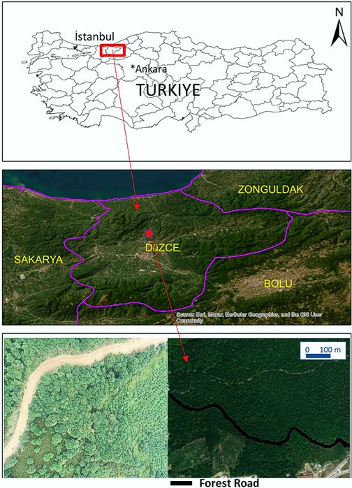
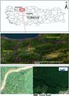
The forest road section with 800-m length was selected as study area located in Düzce FMD (Western Black Sea Region of Türkiye). The road with 526 code number was constructed in 2022. The forest road is a B-type forest road (with 4 m of width of the platform) according to forest categorization in Turkish forestry. Forest road is unpaved, and its longitudinal slope is 7.3%. The geographical coordinates of study are 34° 61’ 33’’East and 45° 61’ 33’’ North. The mean elevation of study area is 150 m above ground level (a.g.l), and covered by dense forests (Figure 1).
Workflow of the Study
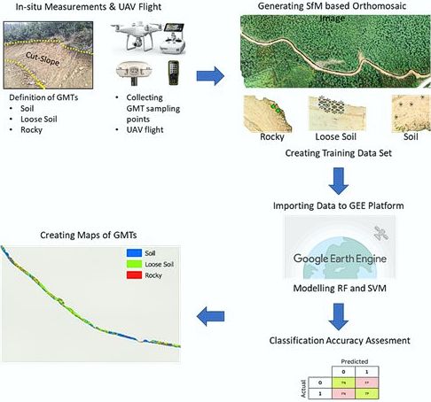
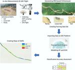
In the study, the classes of Soil, Loose Soil, and Rocky on the cut slope were identified using RS data. For this purpose, in-situ measurements were initially conducted on the forest road together with experts. During these in-situ measurements, both the percentage distributions (%) of the Soil, Loose Soil, and Rocky classes and training data with GPS were generated. The UAV images obtained from the flight conducted over the forest road were classified using RF and SVM algorithms with the generated training data. In this way, the success of the two algorithms in identifying the classes was determined. Intervals of 20 meters (m) were taken from the classified UAV image and evaluated through statistical analyses in conjunction with the percentage distributions of the Soil, Loose Soil, and Rocky classes identified from the in-situ measurements. The workflow for this study was provided in Figure 2.
In-situ Data Collection
Road section was divided into 20-m sections and SMT of cut slopes were determined for each section. The SMT was categorized into soil, loose soil, and rock. The classification was made according to criteria defined in the Communique no. 292 by Directorate General of Forests in Türkiye (GDF 2008). In traditional method applied in Türkiye, SMT are defined in percentage with visual interpretation by the expert in the field. The human expert roughly defines the SMT as like for example 20% rock, 25% loose soil, and 55% soil along the road (=Total 100%), but does not create a SMT map. In the present study, to map SMT of cut slopes, more reliable data collection was carried out. Along the selected road, SMT were defined and point data was collected over the cut slopes for each section. Point data used as training data has surveyed with a Cors-GNSS with cm accuracy. In total, 307 points were collected (Table 1).
The numbers of training data are provided in Table 1. During the collection phase, training data were generated from locations where the SMTs for each category were distinctly different from each other. Because the Rocky SMT is less prevalent on the road, the training data for this class is less compared to the others. Training data, 10% was used as test data for performance evaluation.
UAV flights and Data Process
Following in-situ data collection for surface material classes, a UAV flight was carried out over the road section on 27 June 2022. For this aim, DJI Phantom 4 RTK system was used. The UAV system has 20-megapixel camera with a 1-inch CMOS sensor. The aircraft is equipped with a GNSS module that enables reception of GPS (L1/L2), GLONASS (L1/L2), and Galileo (E1/E5a) satellites. This UAV system is capable of directing georeferencing of the images in real time with centimeter-level positioning accuracy. The flight plan was carried out in photogrammetry (3D) mode, allowing topography-adaptive flights. The SRTM 30-m digital elevation data was downloaded and then imported in “geotiff” format. The UAV image acquisition was planned from 120 m (a.g.l). Both forward and side image overlapping rates were set at 90%. The UAV images were then processed by applying SfM (Structure-from-Motion) algorithm with Agisoft Metashape Professional. The outputs of SfM algorithm are point cloud, digital elevation model, and orthomosaic images. In this study, the orthomosaic image was used for mapping surface material classes of cut slope for the selected road section. The orthomosaic image has 2.94 cm spatial resolution.
Application of ML Approaches for SMT Classification
For mapping surface material classes of selected forest road section, two ML approaches were applied: RF and SVM classification. RF is a community classifier based on the ML method (Breiman, 2001). RF is a non-parametric ML algorithm that provides high classification accuracy. RF uses a random sampling policy to create a new training dataset. By using the random sampling, it reduces the variance and increases the classification accuracy (Liaw and Wiener, 2002). RF algorithm has two different adjustment parameters. When examining the adjustment parameters of RF, the number of trees and the “mtry” used to split the nodes are important. The “mtry” represents the number of randomly selected features at each split point in building a decision tree within the ensemble. The “mtry” determines a subset of features considered by the RF. Among the adjustment parameters of RF, mtry used in node splitting is an important variable that improves the accuracy of classification (Ishwaran and Kogalur, 2007; Sonobe et al., 2017). In this study, the best coefficient for splitting the nodes in RF classification was determined as ‘5’. The formula of the RF method used in this study is given in equation (1).
When examining the formula used to calculate RF, the probability of the selected parameters belonging to class K i is calculated using the formula (f(K i ,M)/|M|), and the probability of belonging to class K j is determined using (f(K j ,M)/|M|) (Pal 2005).
Another method used in the classification of drone images is SVM. SVM algorithm is a non-parametric statistical ML technique used for image classification (Waldner et al., 2015; Sonobe et al., 2017). The SVM algorithm determines the optimal hyperplane to distinguish classes based on training data. The SVM algorithm divides the training data using maximum separation margins (Vapnik, 1995). By using vector data for the training data and averaging the margins, the SVM algorithm creates the optimal hyperplane for classification. SVM can achieve high classification accuracies with a small number of training data (Foody, 2004; Zheng, 2015). The formula (2) for the SVM classification used in this study was provided.
n the SVM formula, the term b represents the bias term, a i represents the Lagrange multiplier, and y i represents the class labels. In K(x, x i ), x is the input vector and x i is the Radial Basis Function kernel function.
Both RF and SVM classification were applied in GEE platform, which offers notable advantages such as being free and user-friendly and provides storing and mapping data, as well as high-speed parallel processing without downloading data (Zhao et al., 2021). Both RF and SVM models were set up by using same data collected from field. While 0.7 of points were used for training, the remaining was used for testing.
Orthomosaic Classification Performance Evaluation
The Kappa coefficient is among the most commonly used statistical methods in image classification. In Kappa Coefficient analysis, the observed agreement between data sets is compared with the agreement expected by chance, providing a statistical explanation of the classified image. The result of the Kappa Coefficient analysis ranges from +1 to -1. A Kappa result approaching +1 indicates perfect agreement, while a result approaching -1 represents disagreement (Gwet, 2002; Sim and Wright, 2005). Kappa Coefficient analysis used in image classification results accuracy assesment was given in equation (3).
In the Kappa equation, Po is determined by dividing the number of agreements by the total number of observations. Pe, on the other hand, is the determination of the probability of coincidences in the image (Gwet, 2002; Sim and Wright, 2005). Another criterion used to evaluate image classification results is Overall Accuracy. Overall Accuracy (%) is calculated by the ratio of the number of correctly classified data to the total amount of data in the dataset. The formula for Overall Accuracy (%) is provided in equation (4).
The result of Overall Accuracy (%) ranges from 0 to 100. Results approaching 0 represent incorrect classification, while values approaching 100 indicate that the image has been correctly classified (Mellor et al., 2013).
Evaluation of ML Models and In-Situ Measurements Results
Statistical calculations were performed to determine the SMTs performance of RF and SVM algorithms applied to drone images. The Agreement Index (IA) (Guo and Wu, 2023) was calculated to assess the agreement between drone and in-situ measurements at 20-meter intervals along the study area road. A SMT is considered successful when IA results were close to 1.0 (Guo and Wu, 2023), indicated high level of accuracy. Equations of these measure were given in Equations (5) as follows:
where n total number of annual measurements, P i is predicted values, O i is observed values, P is mean of the predicted values, Ois mean of the observed values, σ P is standard deviation of the predicted values, σ o is standard deviation of the observed values. IA results vary between 0 and 1. The varying IA results are classified as follows: 0-0.20 ‘Extremely inappropriate’, 0.20-0.40 ‘Inappropriate’, 0.40-0.60 ‘Moderately appropriate’, 0.60-0.80 ‘Very appropriate’ and 0.80-1 ‘Extremely appropriate’ (Guo and Wu, 2023; Al-Jawhar and Rezouki, 2013).
RESULTS
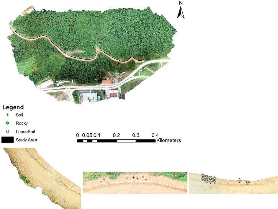
In this study, training data created from in-situ measurements were transferred to UAV-based orthomosaic image for the purpose of image classification. The location of sample training data was given in Figure 3. Both RF and SVM classification methods were applied to map SMT of cut slopes along the road.

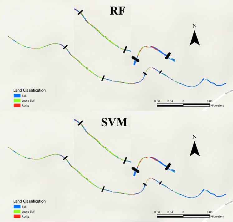
In the field study conducted, training data from the cut slope were generated using GPS. During the production of training data, the TUREF TM 30 EPSG: 5254 coordinate system was used in the GPS. The created orthomosaic is also in the TUREF TM 30 coordinate system. The generated training data was exported from the GPS and saved in CSV format. The recorded training data and orthomosaic were downloaded to GEEp. In GEEp, the downloaded data were subjected to RF and SVM ML classification algorithms using the Java programming language. The classification results of the orthomosaic were presented in Figure 4.

For the statistical assessment of the orthomosaic classified with RF and SVM algorithms, Kappa Coefficient and Overall Accuracy (%) assessments were conducted. To evaluate the internal accuracy of each category of the classified orthomosaic, Conditional Kappa analysis was applied. According to the applied Conditional Kappa analysis, the impact of data in each classified category on the total accuracy was determined. The general Kappa Coefficient, Overall Accuracy (%) and Conditional Kappa results of the orthomosaic classified according to RF and SVM algorithms were given in Table 2.
Kappa Coefficient, Overall Accuracy (%) and Conditional Kappa results of the orthomosaic classified according to the RF and SVM methods.
According to the analysis results, when examining the Kappa Coefficient results, the RF algorithm provided a better classification given compared to SVM. The RF Kappa Coefficient result falls into the “Almost Perfect” category, as per the classification by Shivakumar and Rajashekararadhya (2018), while the SVM classification result is in the “Excellent” category. According to the Conditional Kappa analysis applied to RF and SVM classifications, the highest accuracy was found in the “Rocky” class. The lowest accuracy was in the “Loose Soil” class, and this class lowered the overall Kappa Coefficient in both classifications. The RF and SVM classifications was successful in identifying the “Soil” class, similar to the “Rocky” class. The Overall Accuracy (%) results indicated that classification with the RF algorithm was more successful compared to SVM.
The road orthomosaic classified according to the RF and SVM methods was clipped at 20-meter intervals. A total of 40 different clipped 20-meter interval images were produced from each of the classified UAV images. Each of the produced interval images was install into GEEp. The install classified images were perceived as continuous data in GEEp, so a “threshold” was applied to the data. This allowed the classes in the images to be identified in GEEp, and the “count numbers” were automatically determined from the rows in the data tables of the classified images. The classes were calculated in % using the identified “count numbers. In this way, the data identified by in-situ measurement was made ready for statistical analysis with the classified images. The results related to the data in % detected from in-situ measurement and classified images were given in Table 3 and the descriptive statistics applied to the data were provided in Table 4.
According to SMT area percentage in-situ measurments, each road section has minimum 25% soil in the cut slope area, but Loose Soil and Rocky classes were not observed in some road sections. In other words, some road sections a 100% soil type of SMT. But RF and SVM classification resulted that maximum area of soil type of SMT as 92%, and 81%, respectively. Loose soil type SMT was mapped minimum 8% and 19% with RF and SVM classification in some road sections but its minimum area 0% in in-situ measuremnts. In the In the “Rocky” class, the minimum % results from both RF and SVM classifications are the same as the in-situ measurements.The most accurate % result in the classification was achieved in the “Rocky” class. The percentage distribution results identified in Table 3 were subjected to IA analyses. The results of the statistical analyses were presented in Table 5.
In the RF classification, the highest IA was observed in the Rocky category (0.93), whereas the lowest was detected in the Loose class (0.74). For the SVM classification, the highest IA was found in the Rocky category (0.89), while the lowest IA was in the loose soil class (0.54). When comparing the results of the IA and Conditional Kappa analysis, the results show similarities.
DISCUSSION
Forest road related studies using remote sensing technique such UAV has been increased since they are used as an alternative to traditional in-situ measurements. They are faster, easier and cost-effective. This study aimed to use UAV data for mapping SMT of a forest road selected. 20-m road sections were determined and area percentage of each SMT in each section was calculated. In traditional method applied in Turkish forestry, the definition of SMTs is made by human expert with visual evaluation in the field. The expert roughly estimates the area percentage of SMTs in each section. However, this estimation is not always accurate and precise, and is entirely subjective. In addition, the experience of the human expert plays very important role. Depending on the excavation volume and surface material classes, the forestry administration makes a final payment to the company constructing the road. That’s why, more accurate mapping of SMTs is required. In expert field studies, each 20-meter road section is completed in approximately 7.5 minutes. Additionally, experts are paid $170 for fieldwork. Therefore, for each new forest road construction in Türkiye, cost and time savings cannot be achieved in field studies. In this study, a UAV flight was conducted in approximately 5 minutes with no cost. Therefore, this research aimed to identify SMTs with UAVs and test their applicability in such applications, achieving both cost and time savings. In literature, many different applications were made for forest-road related studies. Many of them was about creating higher spatial resolution data for forest roads (Biçici and Zeybek, 2021; Kınalı and Çalışkan, 2022; Ciritcioğlu and Buğday, 2022; Türk et al., 2022; Hasegawa et al., 2023; Türk and Canyurt 2024), monitoring forest roads degradations (Dobson et al., 2013; Díaz-Vilariño et al., 2016; Hrůza et al., 2016; Akgül et al., 2017; Akay et al., 2018; Akgül et al., 2019; Türk et al., 2019a; Türk et al., 2019b; Eker, 2023; Türk et al., 2024 ), and mapping of forest road-stream crossings (Açıl et al., 2023). However, there is no study in the current literature aiming to map SMTs for forest road using RF classification from high resolution UAV data.
In this study, machine learning algorithms, RF and SVM classifiers, were used to map SMTs. The RF algorithm was a reliable classifier used in remote sensing images. The RF algorithm has been successfully applied in remote sensing data in studies such as urban vegetation mapping (Feng et al., 2015), forest volume and biomass detection (Esteban et al., 2019), land cover classification (Gislason et al., 2006) and flood risk mapping (Farhadi and Najafzadeh 2021). In addition to these studies, it was also possible to see studies on road extraction (Biçici and Zeybek, 2021) used the RF algorithm. In recent years, there have been studies conducted using RF, SVM, and other algorithms for the classification of drone images (Fan, 2023; Zhou et al., 2021; Hosseinalizadeh et al., 2019). Algorithms such as Extreme Gradient Boosting (XGBoost), Logistic Regression (LR), RF, SVM, Artificial Neural Network (ANN), Generalized Additive Model (GAM), K-Nearest Neighbors (KNN), Convolutional Neural Network (CNN), Bayes, and decision tree (DT) have been used in these studies. Among the algorithms used, RF has been one of the algorithms with the highest accuracy. Additionally, Zhou et al. (2021) found that SVM was also successful in classification. The studies focused on land classification, and no study was found that used drone images to detect soil, loose soil and rocky areas on cut slopes. In the study conducted, SMT maps were classified and obtained from drone images using RF, and a Kappa coefficient of 0.85 was determined. It is possible to say that as the Kappa Coefficence (Sim and Wright, 2005) and IA (Al-Jawhar and Rezouki, 2013) value approaches 1, the model’s success increases. When the success of detected soil, loose soil and rocky areas used the SMT created with the RF algorithm was examined, it was observed that Rocky (IA: 0.93) had the best detection performance while loose soil had the lowest detection performance (IA: 0.74). Another algorithm used in creating SMT was SVM. The SVM algorithm has been used in habitat classification (Sanchez-Hernandez et al., 2007), land cover mapping (Pal, 2008; Shi and Yang, 2015 ) and crop classification (Mathur and Foody 2008). When the studies conducted were examined, it was not possible to see the use of the SVM algorithm in detected soil, loose soil, and rocky areas on cut slopes. The SMT map obtained used the SVM algorithm detected Kappa Coefficence of 0.79. According to the SVM algorithm, the highest success rate in classification was for rocky areas (IA: 0.89), while the lowest was for loose soil (IA: 0.54). The reason for the low detection success of loose soil in RF and SVM is that loose soil was in the transition stage with evolution into soil (Gu et al., 2014). Therefore, the algorithms were success in detected loose soil has decreased. In both ML classification algorithms used to create SMT, RF achieved the best performance. In the past studies examined the success of RF and SVM in created SMTs maps (Thanh Noi and Kappas, 2017; Sheykhmousa et al., 2020 ; Sabat-Tomala et al., 2020) have found RF to be more successful than the SVM algorithm. In this study as well, RF best performed rather than SVM in accuracy evaluation. The most important result of this case study is that by choosing RF, the images obtained from UAV flights resulted in better detection of SMTs, providing time and cost saving.
In the present study, a UAV system which has 20 MP CMOS sensor, was used. The integrated sensor takes images in RGB spectral bands. Therefore, classification of SMTs has some limitations. Türk et al. (2022b) discussed limitations of UAV system for forest road surface deformations. Similar limitations are subject for this study. One important limitation is blockage of cut slope by trees in forested areas. Since UAV system take images in nadir-view, tree crowns can blockage the surface. Another important limitation is shadow effect. Trees or high mountains, especially forest road is located in valleys, causes shadowing of the surface resulting misclassification of SMTs. Or sun lights can make some pixels brightener than actual situation which can be reason of misclassification of SMTs. Also, spatial resolution of output ortomosaic image depends on the flight altitude. However, in mapping of SMTs, coarser spatial resolutions by 10-15 centimeters could be acceptable, even though new sensors allow to get higher resolutions (2-3 cm). To overcome such limitations, manual UAV flights can be carried out for mapping SMTs. Also, terrestrial or close-range photogrammetric systems, that were proposed by Eker (2023) and Türk et al. (2024) can be used. As Eker (2023) stated, close-range photogrammetric system could be the best option in eliminating shadow and/or brightness effects since images are taken at lower altitudes. Terrestrial or close-range photogrammetric systems can produce images with higher spatial resolution. Therefore, Soil, Loose, and Rocky classes can be more clearly distinguished from the images. However, the spatial resolution of the orthomosaic in this study is 2.94 cm, which allows for the identification of SMTs on forest roads, and thus does not present a disadvantage. If the spatial resolution of the orthomosaic were in millimeters (mm), higher accuracy results could be determined using the classification methods used.
In addition, another UAV system carrying a multi-spectral sensor (including NIR, SWIR bands) should be tested. Because Abidin and Ariff (2023) states that using multispectral UAV system increase the accuracy of classification in detecting detection of road defects. Besides, spectral signs should be collected by using spectroradiometer to increase confidence of classification. Herold et al. (2008) and Kavzoğlu et al. (2009) used a spectrometer to determine of spectral characteristics of a selected road surface. A similar approach could be applied to map SMTs for forest roads. In this study, a quick and simple application was carried out by using RGB images. When compared to traditional in-situ measurements in Turkish forestry, the current application provided more accurate and reliable results for forestry authorities.
The detection of SMTs on cut slopes is determined using drone images and is also crucial for recovery efforts to be conducted after forest road construction. This is emphasized by the research conducted by Hosogi et al. (2006), which highlights the importance of parameters such as SMTs, slope, and aspect in revegetation efforts on cut slopes. In this study, SMTs were detected from drone images, and environmental parameters such as slope and aspect can also be generated from these images for the cut slope. Therefore, the use of drone images is advantageous. Additionally, research by Hernando and Romana (2015), Al-Bared et al. (2019), Solgi et al. (2021), Navarro-Hevia et al. (2016), Li et al. (2020), and Liu et al. (2019) indicates that soil erosion can occur if recovery efforts are not conducted on cut slopes. These studies emphasize the importance of detecting SMTs on cut slopes and note that soil erosion occurs as a result of rainfall. Therefore, detecting SMTs on cut slopes is crucial for preventing soil erosion and implementing necessary measures.
CONCLUSIONS
Forest roads contribute significantly to the country’s economy by enabling the inventorying of forests. In addition, they provide access to rehabilitation areas for people, resulting in social benefits. Forest roads play a facilitating role in supporting individuals’ physical and mental health by providing access to forests In addition, by facilitating access to educational and cultural activities, they make significant contributions to the cultural services part of ecosystem services for society. Besides the benefits of forest roads, there are also construction costs involved and the distributions of soil, loose soil and rocky areas in cut slopes are determined to identify these costs. In-situ measurements are conducted to determine the distributions of soil, loose soil and rocky areas. In-situ measurements in field studies can be time-consuming and increase costs. In this study, soil, loose soil, and rocky areas in cut slopes were classified using drone images with ML algorithms such as RF and SVM. The soil, loose soil, and rocky areas detected by RF and SVM were compared with in-situ measurements. RF provided the highest accuracy in the classified drone images, particularly in the detection of soil and rocky areas. It is possible to detect soil and rocky areas in cut slopes using SVM as well. However, it can be said that both ML algorithms used in classification are not as successful in detecting loose soil areas as they are in detecting soil and rocky areas. Loose soil detection in drone images can be improved with field studies. Therefore, it is essential to collect more training data with GPS during field studies for the loose soil class. This study indicates that drone images can be used to detect soil and rocky areas in cut slopes but RF one of the ML classification methods, is more suitable for detecting loose soil areas. This study suggests that using drone images for classification can reduce the time spent in field studies and make it possible to determine the construction costs of forest roads. In addition, the importance of detecting SMTs on cut slopes for recovery efforts after forest road construction has also been emphasized.
Data availability
The datasets supporting the conclusions are included in the article.
REFERENCES
-
ABİDİN, M. S. Z.; ARİFF, M. F. M. UAV Photogrammetry for road defects mapping. Journal of Advanced Geospatial Science Technology, v. 3, n.1, p.1-14, 2023. https://doi.org/10.11113/jagst.v3n1.58
» https://doi.org/10.11113/jagst.v3n1.58 -
AÇIL, A.; AYDIN, A.; EKER, R.; DUYAR, A. Use of UAV data and HEC-RAS model for dimensioning of hydraulic structures on forest roads. Croatian Journal of Forest Engineering. Journal for Theory and Application of Forestry Engineering, v. 44, n.1, p. 171-188, 2023. https://doi.org/10.5552/crojfe.2023.1701
» https://doi.org/10.5552/crojfe.2023.1701 -
AGAPİOU, A. Remote sensing heritage in a petabyte-scale: Satellite data and heritage Earth Engine applications. International journal of digital earth, v.10, n.1, p. 85-102, 2017. https://doi.org/10.1080/17538947.2016.1250829
» https://doi.org/10.1080/17538947.2016.1250829 - AKAY, A. O.; AKGUL, M.; DEMİR, M. Determination of temporal changes on forest road pavement with terrestrial laser scanner. Fresenius Environmental Bulletin, v. 27, n.3, p.1437-1448, 2018.
-
AKGUL, M.; AKBURAK, S.; YURTSEVEN, H.; et al. Potential impacts of weather and traffic conditions on road surface performance in terms of forest operations continuity. Applied Ecology and Environmental Research, v.17, n.2, p. 2533-2550, 2019. http://dx.doi.org/10.15666/aeer/1702_25332550
» http://dx.doi.org/10.15666/aeer/1702_25332550 -
AKGUL, M.; YURTSEVEN, H.; AKBURAK, S.; et al. Short term monitoring of forest road pavement degradation using terrestrial laser scanning. Measurement, v. 103, p. 283-293 https://doi.org/10.1016/j.measurement.2017.02.045, 2017
» https://doi.org/10.1016/j.measurement.2017.02.045, 2017 -
AL-BARED, M. A. M.; HARAHAP, I. S. H.; MARTO, A.; et al. Stability of cut slope and degradation of rock slope forming materials-a review. Malaysian Construction Research Journal, v. 6, n. 1, p. 215-228, 2019. https://www.scopus.com/inward/record.uri?eid=2-s2.0-85077391214&partnerID=40&md5=4d3cb2a7c6e07064ebe154d4b2509731
» https://www.scopus.com/inward/record.uri?eid=2-s2.0-85077391214&partnerID=40&md5=4d3cb2a7c6e07064ebe154d4b2509731 -
AL-JAWHAR, H. D.; REZOUKI, S. E. Identifying appropriate procurement systems in the construction industry in Iraq using procurement systems judgment method. Applied Mechanics and Materials, v. 357-360, p. 2885-2889, 2013. https://doi.org/10.4028/www.scientific.net/AMM.357-360.2885
» https://doi.org/10.4028/www.scientific.net/AMM.357-360.2885 -
ALLAMANIS, M.; BARR, E. T.; DEVANBU, P.; et al. A survey of machine learning for big code and naturalness. ACM Computing Surveys (CSUR), v. 51, n. 4, p. 1-37, 2018. https://doi.org/10.1145/3212695
» https://doi.org/10.1145/3212695 -
AMEDE, E. A relationship between productivity and significant controlling factors of highway construction earthwork. Cogent Engineering, v. 9, n. 1, 2114203, 2022. https://doi.org/10.1080/23311916.2022.2114203
» https://doi.org/10.1080/23311916.2022.2114203 -
BERENJI TEHRANI, F.; MAJNOUNIAN, B.; ABDI, E.; et al. Impacts of forest road on plant species diversity in a Hyrcanian Forest, Iran. Croatian Journal of Forest Engineering, v. 36, n. 1, p. 63-71, 2015. https://hrcak.srce.hr/136129
» https://hrcak.srce.hr/136129 -
BICICI, S.; ZEYBEK, M. Effectiveness of training sample and features for random forest on road extraction from UAV-based point cloud. Transportation Research Record, v. 2675, n. 12, p. 401-418, 2021. https://doi.org/10.1177/03611981211029645
» https://doi.org/10.1177/03611981211029645 -
BREIMAN, L. Random forests. Machine Learning, v. 45, n. 1, p. 5-32, 2001. https://doi.org/10.1023/A:1010933404324
» https://doi.org/10.1023/A:1010933404324 -
BRUZZONE, L.; BOVOLO, F. A novel framework for the design of change-detection systems for very-high-resolution remote sensing images. IEEE, v. 101, n. 3, p. 609-630, 2012. doi: https://doi.org/10.1109/JPROC.2012.2197169
» https://doi.org/10.1109/JPROC.2012.2197169 -
BUGDAY, E. Capabilities of using UAVs in forest road construction activities. European Journal of Forest Engineering, v. 4, n. 2, p. 56-62, 2018. https://doi.org/10.33904/ejfe.499784
» https://doi.org/10.33904/ejfe.499784 -
CHANDRA, M. A.; BEDI, S. S. Survey on SVM and their application in image classification. International Journal of Information Technology, v. 13, n. 5, p. 1-11, 2021. https://doi.org/10.1007/s41870-017-0080-1
» https://doi.org/10.1007/s41870-017-0080-1 -
CHENG, B.; JI, H.; WANG, Y. A new method for constructing roads map in forest area using UAV images. Journal of Computational Methods in Sciences and Engineering, p. 1-15, 2023. https://doi.org/10.3233/JCM-226621
» https://doi.org/10.3233/JCM-226621 -
CHONPATATHIP, S.; SUANPAGA, W.; MUTTITANON, W. Earthwork volume measurement in road construction using unmanned aerial vehicle (UAV). International Journal of Geoinformatics, v. 19, n. 12, p. 51-64, 2023. https://doi.org/10.52939/ijg.v19i12.2977
» https://doi.org/10.52939/ijg.v19i12.2977 -
CIRITCIOGLU, M. G.; BUGDAY, E. Assessment of unmanned aerial vehicle use opportunities in forest road project (Düzce sample). Journal of Bartin Faculty of Forestry, v. 24, n. 2, p. 247-257, 2022. https://doi.org/10.24011/barofd.1066636
» https://doi.org/10.24011/barofd.1066636 - CONTRERAS, M.; ARACENA, P.; CHUNG, W. Improving accuracy in earthwork volume estimation for proposed forest roads using a high-resolution digital elevation model. Croatian Journal of Forest Engineering, v. 33, n. 1, p. 125-142, 2012.
-
DIAZ-VILARINO, L.; GONZALEZ-JORGE, H.; MARTINEZ-SANCHEZ, J.; et al. Determining the limits of unmanned aerial photogrammetry for the evaluation of road runoff. Measurement, v. 85, p. 132-141, 2016. https://doi.org/10.1016/j.measurement.2016.02.030
» https://doi.org/10.1016/j.measurement.2016.02.030 -
DOBSON, R. J.; BROOKS, C.; ROUSSİ, C.; COLLİNG, T. Developing an unpaved road assessment system for practical deployment with high-resolution optical data collection using a helicopter UAV. In International Conference on Unmanned Aircraft Systems (ICUAS), p. 235-243, 2013. doi: https://doi.org/10.1109/ICUAS.2013.6564695
» https://doi.org/10.1109/ICUAS.2013.6564695 -
DOLI, A.; BAMWESIGYE, D.; HLAVACKOVA, P.; et al. Forest park visitors’ opinions and willingness to pay for sustainable development of the Germia Forest and Recreational Park. Sustainability, v. 13, n. 6, p. 3160, 2021. https://doi.org/10.3390/su13063160
» https://doi.org/10.3390/su13063160 -
EKER, R. Comparative use of PPK-integrated close-range terrestrial photogrammetry and a handheld mobile laser scanner in the measurement of forest road surface deformation. Measurement, v. 206, p. 112332, 2023. https://doi.org/10.1016/j.measurement.2022.112322
» https://doi.org/10.1016/j.measurement.2022.112322 - EKER, R.; ALKIS, K. C.; UCAR, Z.; et al. Using machine learning in forestry. Turkish Journal of Forestry, v. 24, n. 2, p. 150-177, 2023.
- EKER, R.; AYDIN, A. Assessment of forest road conditions in terms of landslide susceptibility: a case study in Yığılca Forest Directorate (Turkey). Turkish Journal of Agriculture and Forestry, v. 38, n. 2, p. 281-290, 2014.
- ESTEBAN, J.; MCROBERTS, R. E.; FERNANDEZ-LANDA, A.; et al. Estimating forest volume and biomass and their changes using random forests and remotely sensed data. Remote Sensing, v. 11, n. 16, 1944, 2019.
- FAN, C. L. Ground surface structure classification using UAV remote sensing images and machine learning algorithms. Applied Geomatics, v. 15, n. 4, p. 919-931, 2023.
-
FARAGALLAH, R. N.; RAGHEB, R. A. Evaluation of thermal comfort and urban heat island through cool paving materials using ENVI-Met. Ain Shams Engineering Journal, v. 13, n. 3, 101609, 2022. https://doi.org/10.1016/j.asej.2021.10.00
» https://doi.org/10.1016/j.asej.2021.10.00 - FARHADI, H.; NAJAFZADEH, M. Flood risk mapping by remote sensing data and random forest technique. Water, v. 13, n. 21, 3115, 2021.
-
FENG, Q.; LIU, J.; GONG, J. Urban flood mapping based on unmanned aerial vehicle remote sensing and random forest classifier - A case of Yuyao China. Water, v. 7, n. 4, p. 1437-1455, 2015. https://doi.org/10.3390/w7041437
» https://doi.org/10.3390/w7041437 -
FIDELUS-ORZECHOWSKA, J.; WALDYKOWSKI, P.; CHROBAK-ZUFFOVA, A.; et al. Erosion rates for forest roads in the Gorce and Western Tatra Mountains in Southern Poland. Earth Surface Processes and Landforms, v. 50, n. 1, e70001, 2025. https://doi.org/10.1002/esp.70001
» https://doi.org/10.1002/esp.70001 -
FOODY, G. M.; MATHUR, A. Toward intelligent training of supervised image classifications: Directing training data acquisition for SVM classification. Remote Sens. Environ, 93, pp. 107-117, 2004. https://doi.org/10.1016/j.rse.2004.06.017
» https://doi.org/10.1016/j.rse.2004.06.017 -
GDF. Forest roads planning, construction and maintenance. https://www.ogm.gov.tr/tr/e-kutuphane-sitesi/mevzuat-sitesi/Tebligler/Orman%20Yollar%C4%B1%20Planlamas%C4%B1,%20Yap%C4%B1m%C4%B1%20ve%20Bak%C4%B1m%C4%B1%20(292%20Say%C4%B1l%C4%B1%20Tebli%C4%9F).pdf Accessed in: 26.12.2024.
» https://www.ogm.gov.tr/tr/e-kutuphane-sitesi/mevzuat-sitesi/Tebligler/Orman%20Yollar%C4%B1%20Planlamas%C4%B1,%20Yap%C4%B1m%C4%B1%20ve%20Bak%C4%B1m%C4%B1%20(292%20Say%C4%B1l%C4%B1%20Tebli%C4%9F).pdf - GISLASON, P. O.; BENEDIKTSSON, J. A.; SVEINSSON, J. R. Random forests for land cover classification. Pattern Recognition Letters, v. 27, n. 4, p. 294-300, 2006.
- GOVENDER, T.; DUBE, T.; SHOKO, C. Remote sensing of land use-land cover change and climate variability on hydrological processes in Sub-Saharan Africa: Key scientific strides and challenges. Geocarto International, v. 37, n. 25, p. 10925-10949, 2022.
- GU, X.; HUANG, M.; QIAN, J. DEM investigation on the evolution of microstructure in granular soils under shearing. Granular Matter, v. 16, n. 1, p. 91-106, 2014.
- GUO, Q.; WU, W. Application of parameter optimization methods based on Kalman formula to the soil-crop system model. International Journal of Environmental Research and Public Health, v. 20, n. 5, p. 4567, 2023.
- GWET, K. Kappa statistic is not satisfactory for assessing the extent of agreement between raters. Statistical Methods for Inter-Rater Reliability Assessment, v. 1, n. 6, p. 1-6, 2002.
-
HASEGAWA, H.; SUJASWARA, A. A.; KANEMOTO, T.; et al. Possibilities of using UAV for estimating earthwork volumes during process of repairing a small-scale forest road, Kyoto Prefecture, Japan. Forests, v. 14, n. 4, p. 677, 2023. https://doi.org/10.3390/f14040677
» https://doi.org/10.3390/f14040677 -
HERNANDO, D.; ROMANA, M. G. Development of a soil erosion classification system for cut and fill slopes. Transportation Infrastructure Geotechnology, v. 2, p. 155-166, 2015. https://doi.org/10.1007/s40515-015-0024-9
» https://doi.org/10.1007/s40515-015-0024-9 -
HEROLD, M.; ROBERTS, D.; NORONHA, V.; SMADI, O. Imaging spectrometry and asphalt road surveys. Transportation Research Part C: Emerging Technologies, v. 16, n. 2, p. 153-166, 2008. https://doi.org/10.1016/j.trc.2007.07.001
» https://doi.org/10.1016/j.trc.2007.07.001 -
HOLLOWAY, J.; MENGERSEN, K. Statistical machine learning methods and remote sensing for sustainable development goals: A review. Remote Sensing, v. 10, n. 9, p. 1365, 2018. https://doi.org/10.3390/rs10091365
» https://doi.org/10.3390/rs10091365 -
HOSOGI, D.; YOSHINAGA, C.; NAKAMURA, K.; et al. Revegetation of an artificial cut-slope by seeds dispersed from the surrounding vegetation. Landscape and Ecological Engineering, v. 2, p. 53-63, 2006. https://doi.org/10.1007/s11355-005-0024-y
» https://doi.org/10.1007/s11355-005-0024-y -
HOSSEINALIZADEH, M.; KARIMINEJAD, N.; CHEN, W.; et al. Gully headcut susceptibility modeling using functional trees, naïve Bayes tree, and random forest models. Geoderma, v. 342, p. 1-11, 2019. https://doi.org/10.1016/j.geoderma.2019.01.050
» https://doi.org/10.1016/j.geoderma.2019.01.050 - HOSSEINI, S. A.; KHALILPOUR, H.; NEJAD, A. M.; et al. Comparing the expenses of forest road cut and fill operations with standard rules (Study Area: Northern Forests of Iran). European Journal of Experimental Biology, v. 2, n. 4, p. 1023-1028, 2012.
-
HRUZA, P.; MIKITA, T.; JANATA, P. Monitoring of forest hauling roads wearing course damage using unmanned aerial systems. Acta Universitatis Agriculturae et Silviculturae Mendelianae Brunensis, 2016. http://dx.doi.org/10.11118/actaun201664051537
» http://dx.doi.org/10.11118/actaun201664051537 - ISHWARAN, H.; KOGALUR, U. B. Random survival forests for R. R News, v. 7, n. 2, p. 25-31, 2007.
-
JEONG, E.; CHO, M.; CHO, H.; et al. Characteristics of forest road cut slopes affecting the movement of mammals in South Korea. Forest Science and Technology, v. 17, n. 3, p. 155-161, 2021. https://doi.org/10.1080/21580103.2021.1967789
» https://doi.org/10.1080/21580103.2021.1967789 -
KAVZOGLU, T.; SEN, Y. E.; CETIN, M. Mapping urban road infrastructure using remotely sensed images. International Journal of Remote Sensing, v. 30, n. 7, p. 1759-1769, 2009. https://doi.org/10.1080/01431160802639582
» https://doi.org/10.1080/01431160802639582 - KHOIROM, S.; SONIA, M.; LAIKHURAM, B.; et al. Comparative analysis of Python and Java for beginners. International Research Journal of Engineering and Technology, v. 7, n. 8, p. 4384-4407, 2020.
- KINALI, M.; CALISKAN, E. Use of unmanned aerial vehicles in forest road projects. Journal of Bartin Faculty of Forestry, v. 24, n. 3, p. 530-541, 2022.
- KREMIC, E.; SUBASI, A. Performance of random forest and SVM in face recognition. International Arab Journal of Information Technology, v. 13, n. 2, p. 287-293, 2016.
-
KUMAR, M.; SINGH, P.; SINGH, P. Machine learning and GIS-RS-based algorithms for mapping groundwater potentiality in the Bundelkhand Region, India. Ecological Informatics, v. 74, p. 101980, 2023. https://doi.org/10.1016/j.ecoinf.2023.101980
» https://doi.org/10.1016/j.ecoinf.2023.101980 - LARY, D. J.; ALAVI, A. H.; GANDOMI, A. H.; et al. Machine learning in geosciences and remote sensing. Geoscience Frontiers, v. 7, n. 1, p. 3-10, 2016.
- LASCHI, A.; FODERI, C.; FABIANO, F.; et al. Forest road planning, construction and maintenance to improve forest fire fighting: a review. Croatian Journal of Forest Engineering, v. 40, n. 1, p. 207-219, 2019.
- LEHTO, C.; SIREN, A.; HEDBLOM, M.; et al. A conceptual framework of indicators for the suitability of forests for outdoor recreation. Ambio, v. 54, n. 2, p. 184-197, 2025.
-
LEMENKOVA, P.; DEBEIR, O. R libraries for remote sensing data classification by k-means clustering and NDVI computation in Congo River Basin, DRC. Applied Sciences, v. 12, n. 24, p. 12554, 2022. https://doi.org/10.3390/app122412554
» https://doi.org/10.3390/app122412554 -
LI, L.; LAN, H.; PENG, J. Loess erosion patterns on a cut-slope revealed by LiDAR scanning. Engineering Geology, v. 268, 105516, 2020. https://doi.org/10.1016/j.enggeo.2020.105516
» https://doi.org/10.1016/j.enggeo.2020.105516 - LI, Y.; HUANG, X.; LIU, H. Unsupervised deep feature learning for urban village detection from high-resolution remote sensing images. Photogrammetric Engineering and Remote Sensing, v. 83, n. 8, p. 567-579, 2017.
- LIAO, W.; CHANUSSOT, J.; DALLA MURA, M.; et al. Taking optimal advantage of fine spatial resolution: promoting partial image reconstruction for the morphological analysis of very-high-resolution images. IEEE Geoscience and Remote Sensing Magazine, v. 5, n. 2, p. 8-28, 2017
- LIAW, A.; WIENER, M. Classification and regression by random forest. R News, v. 2, p. 18-22, 2002.
-
LIU, G.; HU, F.; ZHENG, F.; et al. Effects and mechanisms of erosion control techniques on stairstep cut-slopes. Science of the Total Environment, v. 656, p. 307-315, 2019. https://doi.org/10.1016/j.scitotenv.2018.11.385
» https://doi.org/10.1016/j.scitotenv.2018.11.385 - MATHUR, A.; FOODY, G. M. Multiclass and binary SVM classification: implications for training and classification users. IEEE Geoscience and Remote Sensing Letters, v. 5, n. 2, p. 241-245, 2008.
- MELLOR, A.; HAYWOOD, A.; STONE, C.; et al. The performance of random forests in an operational setting for large-area sclerophyll forest classification. Remote Sensing, v. 5, n. 6, p. 2838-2856, 2013.
- NAVARRO-HEVIA, J.; LIMA-FARIAS, T. R.; DE ARAUJO, J. C.; et al. Soil erosion in steep road cut slopes in Palencia (Spain). Land Degradation and Development, v. 27, n. 2, p. 190-199, 2016
- OANCEA, B.; DRAGOESCU, R. M. Integrating R and hadoop for big data analysis. Revista Română de Statistică, v. 2, 83-91, 2014.
- PAL, M. Ensemble of support vector machines for land cover classification. International Journal of Remote Sensing, v. 29, n. 10, p. 3043-3049, 2008.
- PAL, M. Random forest classifier for remote sensing classification. International Journal of Remote Sensing, v. 26, n. 1, p. 217-222, 2005.
- PARK, S.; KIM, J. H.; BYUN, C.; et al. Identification of restoration species for early roadcut slope regeneration using functional group approach. Restoration Ecology, v. 29, n. 7, e13424, 2021.
-
PARSAKHOO, A.; HOSSEINI, S. A. Effect of bioengineering treatments on reduction of soil erosion from road cut slope and fill slope. Journal of Forest Science, v. 69, n. 9, p. 367-376, 2023. https://doi.org/10.17221/55/2023-JFS
» https://doi.org/10.17221/55/2023-JFS - POONA, N. K.; VAN NIEKERK, A.; NADEL, R. L.; ISMAIL, R. Random forest (RF) wrappers for waveband selection and classification of hyperspectral data. Applied Spectroscopy, v. 70, n. 2, p. 322-333, 2016.
- SABAT-TOMALA, A.; RACZKO, E.; ZAGAJEWSKI, B. Comparison of support vector machine and random forest algorithms for invasive and expansive species classification using airborne hyperspectral data. Remote Sensing, v. 12, n. 3, 516, 2020.
- SANCHEZ-HERNANDEZ, C.; BOYD, D. S.; FOODY, G. M. Mapping specific habitats from remotely sensed imagery: support vector machine and support vector data description-based classification of coastal saltmarsh habitats. Ecological Informatics, v. 2, n. 2, p. 83-88, 2007.
-
SCHULZ, K.; HÄNSCH, R.; SÖRGEL, U. Machine learning methods for remote sensing applications: an overview. Earth Resources and Environmental Remote Sensing/GIS Applications IX, 2018. https://doi.org/10.1117/12.2503653
» https://doi.org/10.1117/12.2503653 - SHAMSHİRİ, R. R.; HAMEED, I. A.; PİTONAKOVA, L.; WELTZİEN, C.; BALASUNDRAM, S, K.; YULE, I, J. et al. Simulation software and virtual environments for acceleration of agricultural robotics: Features highlights and performance comparison. International Journal of Agricultural and Biological Engineering, 11(4), 15-31, 2018.
- SHEYKHMOUSA, M.; MAHDİANPARİ, M.; GHANBARİ, H.; MOHAMMADİMANESH, F.; GHAMİSİ, P.; HOMAYOUNİ, S. Support vector machine versus random forest for remote sensing image classification: A meta-analysis and systematic review. IEEE Journal of Selected Topics in Applied Earth Observations and Remote Sensing, 13, 6308-6325, 2020.
- SHİ, D.; YANG, X. Support vector machines for land cover mapping from remote sensor imagery. Monitoring and Modeling of Global Changes. A Geomatics Perspective, 265-279, 2015.
- SHAMSHIRI, R. R.; HAMEED, I. A.; PITONAKOVA, L.; et al. Simulation software and virtual environments for acceleration of agricultural robotics: features, highlights and performance comparison. International Journal of Agricultural and Biological Engineering, v. 11, n. 4, p. 15-31, 2018.
- SHEYKHMOUSA, M.; MAHDIANPARI, M.; GHANBARI, H.; et al. Support vector machine versus random forest for remote sensing image classification: a meta-analysis and systematic review. IEEE Journal of Selected Topics in Applied Earth Observations and Remote Sensing, v. 13, p. 6308-6325, 2020.
- SHI, D.; YANG, X. Support vector machines for land cover mapping from remote sensor imagery. Monitoring and Modeling of Global Changes: A Geomatics Perspective, p. 265-279, 2015.
-
SHIRMARD, H.; FARAHBAKHSH, E.; MÜLLER, R. D.; CHANDRA, R. A review of machine learning in processing remote sensing data for mineral exploration. Remote Sensing of Environment, v. 268, 112750, 2022. https://doi.org/10.1016/j.rse.2021.112750
» https://doi.org/10.1016/j.rse.2021.112750 - SHIVAKUMAR, B. R.; RAJASHEKARARADHYA, S. V. An investigation on land cover mapping capability of classical and fuzzy-based maximum likelihood classifiers. International Journal of Engineering Technology, v. 7, n. 2, p. 939, 2018.
- SIM, J.; WRIGHT, C. C. The kappa statistic in reliability studies: use, interpretation, and sample size requirements. Physical Therapy, v. 85, n. 3, p. 257-268, 2005.
- SOLGI, A.; NAGHDI, R.; ZENNER, E. K.; et al. Evaluating the effectiveness of mulching for reducing soil erosion in cut slope and fill slope of forest roads in Hyrcanian Forests. Croatian Journal of Forest Engineering, v. 42, n. 2, p. 259-268, 2021.
- SONOBE, R.; YAMAYA, Y.; TANI, H.; et al. Assessing the suitability of data from Sentinel-1A and 2A for crop classification. GIScience and Remote Sensing, v. 54, n. 6, p. 918-938, 2017.
- TAMIMINIA, H.; SALEHI, B.; MAHDIANPARI, M.; et al. Google Earth Engine for geo-big data applications: a meta-analysis and systematic review. ISPRS Journal of Photogrammetry and Remote Sensing, v. 164, p. 152-170, 2020.
- TAMPEKIS, S.; SAMARA, F.; SAKELLARIOU, S.; et al. An eco-efficient and economical optimum evaluation technique for forest road networks: the case of the mountainous forest of Metsovo, Greece. Environmental Monitoring and Assessment, v. 190, p. 1-15, 2018.
- TANG, L.; SHAO, G. Drone remote sensing for forestry research and practices. Journal of Forestry Research, v. 26, p. 791-797, 2015.
-
TARAZONA, Y.; BENITEZ-PAEZ, F.; NOWOSAD, J.; et al. Scikit-eo: a Python package for remote sensing data analysis. Journal of Open Source Software, v. 9, n. 99, 6692, 2024. https://doi.org/10.21105/joss.06692
» https://doi.org/10.21105/joss.06692 - THANH NOI, P.; KAPPAS, M. Comparison of random forest, k-nearest neighbor, and support vector machine classifiers for land cover classification using Sentinel-2 imagery. Sensors, v. 18, n. 1, p. 18, 2017.
- TÜRK, Y.; AYDIN, A.; EKER, R. Effectiveness of open-top culverts in forest road deformations: preliminary results from a forest road section, Düzce-Turkey. In: Proceedings of the 2nd International Symposium of Forest Engineering and Technologies, p. 147-152, 2019b.
- TÜRK, Y.; AYDIN, A.; EKER, R. Comparison of autonomous and manual UAV flights in determining forest road surface deformations. European Journal of Forest Engineering, v. 8, n. 2, p. 77-84, 2022b.
- TÜRK, Y.; BOZ, F.; AYDIN, A.; et al. Evaluation of UAV usage possibility in determining forest road pavement degradation: preliminary results. In: Proceedings of the 3rd International Engineering Research Symposium, p. 630-633, 2019a.
- TÜRK, Y.; CANYURT, H. Capabilities of using UAVs to determine forest road excavation volumes in mountainous areas. Sumarski List, v. 148, n. 3-4, p. 137-150, 2024.
-
TÜRK, Y.; CANYURT, H.; EKER, R.; et al. Determination of forest road cut and fill volumes using unmanned aerial vehicles: a case study in the Bolu-Taşlıyayla. Turkish Journal of Forestry Research, 2022a. https://doi.org/10.17568/ogmoad.1093695
» https://doi.org/10.17568/ogmoad.1093695 -
TÜRK, Y.; ÖZÇELIK, V.; AKDUMAN, E. Capabilities of using UAVs and close-range photogrammetry to determine short-term soil losses in forest road cut slopes in semi-arid mountainous areas. Environmental Monitoring and Assessment, v. 196, n. 1, 149, 2024. https://doi.org/10.1007/s10661-024-12339-1
» https://doi.org/10.1007/s10661-024-12339-1 - VAPNIK, V. N. The nature of statistical learning theory. Springer, Berlin, 1995.
- WALDNER, F.; CANTO, G. S.; DEFOURNY, P. Automated annual cropland mapping using knowledge-based temporal features. ISPRS Journal of Photogrammetry and Remote Sensing, v. 110, p. 1-13, 2015.
- WANG, J.; SUN, K.; CHENG, T.; et al. Deep high-resolution representation learning for visual recognition. IEEE Transactions on Pattern Analysis and Machine Intelligence, v. 43, n. 10, p. 3349-3364, 2020.
-
WANG, Q.; WANG, X.; ZHOU, Y.; et al. The dominant factors and influence of urban characteristics on land surface temperature using random forest algorithm. Sustainable Cities and Society, v. 79, 103722, 2022. https://doi.org/10.1016/j.scs.2022.103722
» https://doi.org/10.1016/j.scs.2022.103722 - WUEST, T.; WEIMER, D.; IRGENS, C.; et al. Machine learning in manufacturing: advantages, challenges, and applications. Production & Manufacturing Research, v. 4, n. 1, p. 23-45, 2016.
- XING, E. P.; HO, Q.; XIE, P.; et al. Strategies and principles of distributed machine learning on big data. Engineering, v. 2, n. 2, p. 179-195, 2016.
-
XIONG, J.; LIN, C.; CAO, Z.; et al. Development of remote sensing algorithm for total phosphorus concentration in eutrophic lakes: conventional or machine learning? Water Research, v. 215, 118213, 2022. https://doi.org/10.1016/j.watres.2022.118213
» https://doi.org/10.1016/j.watres.2022.118213 - XIE, Y.; SHA, Z.; YU, M. Remote sensing imagery in vegetation mapping: a review. Journal of Plant Ecology, v. 1, n. 1, p. 9-23, 2008.
-
YU, J.; ZHAO, Q.; YU, Z.; et al. A review of the sediment production and transport processes of forest road erosion. Forests, v. 15, n. 3, 454, 2024. https://doi.org/10.3390/f15030454
» https://doi.org/10.3390/f15030454 - ZHANG, C.; LIU, C.; ZHANG, X.; et al. An up-to-date comparison of state-of-the-art classification algorithms. Expert Systems with Applications, v. 82, p. 128-150, 2017.
- ZHANG, L.; ZHANG, L.; DU, B. Deep learning for remote sensing data: a technical tutorial on the state of the art. IEEE Geoscience and Remote Sensing Magazine, v. 4, n. 2, p. 22-40, 2016.
- ZHAO, Z.; LIU, Z. Y.; XU, C. Slope unit-based landslide susceptibility mapping using certainty factor, support vector machine, random forest, CF-SVM and CF-RF models. Frontiers in Earth Science, v. 9, 589630, 2021.
- ZHENG, B.; MYINT, S. W.; THENKABAIL, P. S.; et al. A support vector machine to identify irrigated crop types using time-series Landsat NDVI data. International Journal of Applied Earth Observation and Geoinformation, v. 34, p. 103-112, 2015.
- ZHOU, R.; YANG, C.; LI, E.; et al. Object-based wetland vegetation classification using multi-feature selection of unoccupied aerial vehicle RGB imagery. Remote Sensing, v. 13, n. 23, 4910, 2021.
-
Scientific Editor:
Luciano Cavalcante de Jesus França