 UAVs monitoring of open-pit mining site rehabilitation in mountainous forest areas: the case of the Turkey-Western Black Sea Region
ABSTRACT
Background: Mining has a long history and significantly impacts national economies, but it also causes considerable environmental damage. Forest areas are particularly affected, and sustainable management practices are essential for natural resource utilization. Effective rehabilitation of open-pit mining sites is crucial before, during, and after mining operations This study focuses on the rehabilitation process of an open-pit mining site located at the boundary of mountainous forest areas. Landform (slope geometries) measurements and boundary checks were conducted using the UAV-based PPK method. UAV flights were conducted at two different times over a period of approximately seven months. Orthophoto images and DEMs from both flights were used to measure slope width, height, and angle, and to monitor boundary violations during the rehabilitation process. The calculation of slope geometry values was performed using ArcGIS software.
Results: Results indicate that the quarry area expanded by 1,044 m², its perimeter increased by 25 meters, and the slope grade changed over the seven months. According to the results of the first and second flights, the average slope width, height, and angle were 7.39 m, 12.45 m, and 83.46°, respectively, in the first flight, and 16.09 m, 13.33 m, and 40.48°, respectively, in the second flight. Additionally, no boundary violations of the quarry were detected.
Conclusions: The UAV-based PPK method effectively prevented data loss in rugged and difficult-to-access quarry areas. This study demonstrates that public administration can use UAV systems to monitor and control rehabilitation works during and after mining activities.
Keywords:
Rehabilitation; PPK Mode; Slope Geometry; Field Survey; Türkiye
HIGHLIGHTS
The geometry of the quarry in the rehabilitation process was easily measured with UAV. In 7 months, the quarry area has expanded by 1044 m² and its perimeter by 25 m. The results were not consistent with the required rehabilitation values. By using the UAV-based PPK method, data losses in difficult areas were prevented.
INTRODUCTION
With the increase in the human population in the world, an increase in the consumption of natural resources is also observed (Kalaycı and Uzun, 2017; Özşahin et al., 2018). The principle of sustainability is taken into consideration in the management and utilization of natural resources and requires observations and measurements to be made at certain time intervals. These observations and measurements can cover a wide range of interdisciplinary research involving economic, ecological and social balances (Carabassa et al., 2019; Gann et al., 2019; WBCSD, 2019).
Open-pit mining, or in other words, surface mining, is a type of production applied in areas where the ore is located close to the surface of the earth, in order to extract it economically by removing the cover layer on the mine when necessary. The spread and size of the ore close to the surface have enabled open-pit mining to diversify within itself. (MEUCC, 2020). In the open-pit mining method, the activities can be listed as preparing the surface by removing vegetation and topsoil, breaking the rock layers or breaking them with the help of explosives, loading the cover layer and removing it from the land, and extracting the mine and removing it from the land (Kalaycı and Uzun, 2016). Although mining operations have a great contribution to national economies, it is widely recognized that they also have major and various negative impacts on the environment. These impacts include loss of productive forest and soil, sinkhole formation, loss of biodiversity, pollution of groundwater, etc. (Zhu et al., 2020).
Restoration works for the reorganization and improvement of the nature disturbed by mining activities include a series of planning and implementation works before, during, and after the operation. Post-operational nature restoration can be realized through the planned and sequential implementation of reclamation, rehabilitation, monitoring, and inspection works (Ulusoy and Ayaşlıgil, 2012). Rehabilitation works generally include landform, soil, and vegetation works (Kalaycı and Uzun, 2016). Areas disturbed as a result of mining activities are used for original land use, forest, agriculture, recreation, nature conservation and wildlife, residential and industrial uses, special reserves, solid waste and rubble storage areas, etc. (Topay et al., 2007; Bangian et al., 2012).
Many geotechnical applications, including civil works, are carried out in mining sites for the purpose of operation, and the natural soil structure and soil cover are changed. Measures are taken in different categories in order to reduce or improve the negative impacts that may occur at the boundaries of the land where surface mining is carried out and in the immediate vicinity (Festin et al., 2019). Stabilization of excavation slopes resulting from surface mining has an important place in engineering science. Slopes may fail by falling, overturning, sliding, spreading, yielding, or combining types of stability (Özgenoğlu, 1986). In the areas where the materials generated during and after surface mining activities are stored or in the slopes created; the material forming the slope cannot resist gravity and moves downwards. Natural or artificial reinstatement of sites whose stability effects have been reduced and whose natural structure has been disturbed (Pratiwi et al., 2021). Thus, the factors affecting stability are eliminated or reduced except for an environmentally sensitive working activity. Measurement science and techniques are utilized to prevent significant deformation or movement by eliminating the stress to which a structure is exposed (Festin et al., 2019; Ren et al., 2019).
Control supervisors in the public administration are responsible for monitoring and inspecting quarries. These supervisors monitor the quarry permit limits and check whether the slope step widths, heights, and angles are made according to the standards. According to the law applied in Turkey, the quarry operator submits to the public administration a technical report prepared by experts on the stages of the rehabilitation process in the area where the quarry operator carries out mining activities every year according to the implementation schedule. The rehabilitation project shall be prepared by the quarry operator within one year after the completion of the mining activity, and the site shall be made suitable for use. At the end of the three-year follow-up period following the completion of the rehabilitation by the operator or according to the type of mine, the follow-up periods given in the rehabilitation project are taken as basis. Control supervisors in public administration determine whether the commitments made under the rehabilitation project have been fulfilled. If it is determined that these conditions are met, the responsibility of the operator for the area where the mining activity is carried out is terminated (RTOG, 2010).
Several methods and criteria are available in the scientific literature to assess and measure quarry restoration (Zipper et al., 2011; Espinoza et al., 2013; Macdonald et al., 2015; Carabassa et al., 2019; Zhu et al., 2020), but they are very specialized and time-consuming. There is also a lack of appropriate assessment tools for technicians involved in such activities, such as quarry engineers, restoration managers, and quality control supervisors in public administration (Carabassa et al., 2019). In the management of natural resources, the use of decision support systems is an important tool in studies that observe the balance of utilization and conservation. Geographic Information Systems (GIS) and remote sensing (RS) techniques are often favored in all natural resource management science-related research (Chen et al., 2018; Zhu et al., 2020; McKenna et al., 2020).
In mountainous mining areas with difficult terrain conditions, obtaining data with traditional surveying techniques is very labor-intensive and tiring. Today, UA methods are more preferred instead of traditional ground surveying techniques, which are costly. With the development of technology, ground, aerial, and satellite-based data collection methods provide great advantages in terms of speed and cost. The data collected with modern methods and tools are quickly analyzed and made available to applied disciplines (Kabadayi and Uysal, 2019). Robotic systems developed in recent years provide researchers with different measurement techniques, saving time and economy. Rapidly gaining momentum are UAV systems, evaluated within the scope of close-up photogrammetry and classified into various classes (Watts et al., 2012). These systems are preferred for measurement and evaluation studies covering sciences such as forestry, agriculture, mining, construction, etc. due to their temporal flexibility and ability to produce precise data (Colomina and Molina, 2014; Akgül et al., 2016; Tercan, 2018; Türk et al., 2024).
Over the last decade, multiple earth observation and UAV-based sensors in a wide range of study locations have contributed to the growing understanding of post-mining vegetation development (McKenna et al., 2020). UAV systems are utilized in the implementation of the project prepared for the monitoring of mining activities, improvement, and regulation of natural habitats or selected for this purpose (Ren et al., 2019). UAV systems are used in monitoring the boundaries of quarry operation permit areas, in areas that can be used as settlements within or outside the boundaries of the neighbourhood area, or in areas planned to be opened for daily use. In addition, in the case of slope and slope stability with trenching; these systems can be used as a surveying technique in monitoring the slope angle, slope step width, and height criteria (Kun and Özcan, 2019; Yavuz, 2019) and calculating the excavation-filling volume (Raeva et al., 2016; Ulvi, 2018; Tucci et al., 2019; Canh et al., 2020; Türk et al., 2022). In models requiring high precision and accuracy, the position information obtained from the GNSS-GPS module on the UAV is insufficient. Different GNSS techniques are used to ensure that the position parameters of the UAV have centimeter accuracy (Rehak et al., 2013). This high precision includes direct georeferencing, real-time kinematics (RTK) and post-process kinematics (PPK) technologies (Taddia et al., 2020). PPK measurement technique provides an alternative solution in areas where the topographical structure and the coverage limits of the stations providing data are not suitable for satellite-based positioning (forested and mountainous areas) (Eker et al., 2021).
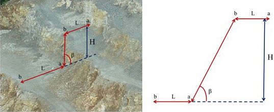
In Turkey, quarries are inspected by control supervisors in the public administration every month during their operation. In these controls, whether there is a discrepancy between the delivered site and the used site, whether there is any other activity other than the permitted activity, whether there is any other facility other than the permitted facilities, whether there is any damage by using forest roads, whether the rehabilitation project is complied with (slope angle, slope step width and height, boundary violation), and other deficiencies detected, if any (RTOG, 2010). In engineering science, excavation slopes are formed as a result of surface mining. The angle of the ground surface with the horizontal is called “slope.” Slope is also used in the sense of sloping surface. The angle of the slope with the horizontal is the “slope angle.” The vertical distance between the base of the slope and its upper surface is called “slope height.” The point where the surface of the slope and the base of the slope intersect is called the “slope heel.” The part between the slope heel and the top of the slope is defined as “slope width” (Figure 1).

Slope parameters: β) slope angle, H) slope height, L) slope width, a) slope heel, b) slope crest and ab) slope surface.
In order to reduce rehabilitation costs, rehabilitation works should also be considered during mining activities (WBCSD, 2019). For mining sites operating within forest boundaries, the regulation applied in Turkey states that control inspectors in the public administration control rehabilitation works while mining activities are in progress (RTOG, 2010). In forest areas, reconstructing the landform modelled according to natural systems and creating topographic heterogeneity at various scales is the first of the reclamation works (Macdonald et al., 2015).
The width, height, and angle values of the slope steps to be rehabilitated should be compatible with the values in the contract with the public administration of the mine operator. In order to control these values, coordinates are taken at certain intervals from the innermost and outermost parts of each slope step with the help of Cors-GPS. After the received data is computerized, measurements are made to check whether the width, height, and angles of the slope steps are suitable for rehabilitation of the mine pit. However, since the open mine sites are generally located in mountainous areas, the topography is rugged and difficult to access, and the field measurement methods are more difficult and time-consuming in terms of occupational safety. In this study, the UAV-based PPK method was used to obtain data, and the disadvantages of other methods were eliminated.
The aim of this study is to measure the landform (slope geometries: slope step, width, and angles) and boundary tracking using the UAV-based PPK method during the rehabilitation process of an open-pit mining site located in mountainous forest boundaries.
MATERIAL AND METHODS
Study area
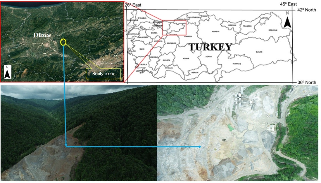
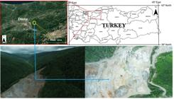
The study area was selected as an open-pit mining operation operated by a private company within the boundaries of Tatlıdere (Düzce/Turkey) Forest Management Sub-Directorate (FMS) located in the southwest of the Western Black Sea Region (Figure 2). The quarry, which is approximately 16 km away from the city center, has an average elevation of 430 m above sea level and is an II-A limestone site. The quarry permit area is approximately 112237 m² and the works were started in 2012, and production is still continuing. In the study area, UAV flights were carried out in two different time periods, and the quarry was monitored for approximately 7 months. The total area of Tatlıdere FMS is 4428 ha, of which 4090 ha is forested and 338 ha is unforested. The quarry subject to the study operates in a forest area.
Due to its location, Tatlıdere FMS is under the influence of both the Black Sea Climate Zone and the Central Anatolian Climate Zone. The average annual temperature of the region is 13.2 °C, and the average annual rainfall is 833.5 mm. The annual average highest temperature of the study area is 19.4 °C, and the average lowest temperature is 8.6 °C. The highest temperature was 42.4 ºC in July, and the lowest temperature was -20.5 ºC in January. Differences in the climatic characteristics of the region have led to the formation of a rich range of plant diversity. The forests of the plan unit are generally leafy forests. The main tree species of Tatlıdere FMS are beech (Fagus orientalis), hornbeam (Carpinus betulus), sessile oak (Quercus petraea), yellow pine (Pinus sylvestris), and larch (Pinus nigra). There is a stand of beech (Fagus orientalis) in the study area (Türk and Balaban, 2025).
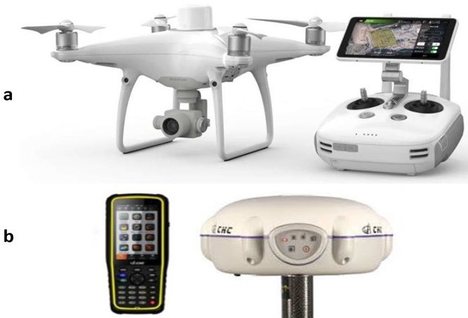
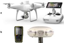
In the study, the first flight was performed on 30 September 2021, and the second flight was performed on 19 May 2022 with the DJI Phantom 4 RTK UAV platform, and a CHCN X91 GNSS receiver (centimeter accuracy) was used for coordinate receiving (Figure 3). The DJI Phantom 4 RTK platform is equipped with a 20-megapixel camera capable of taking photos in the visible range (RGB) provided by the manufacturer. The UAV system is equipped with a multi-frequency RTK/PPK GNSS module that provides high position accuracy.
Obtaining UAV digital images
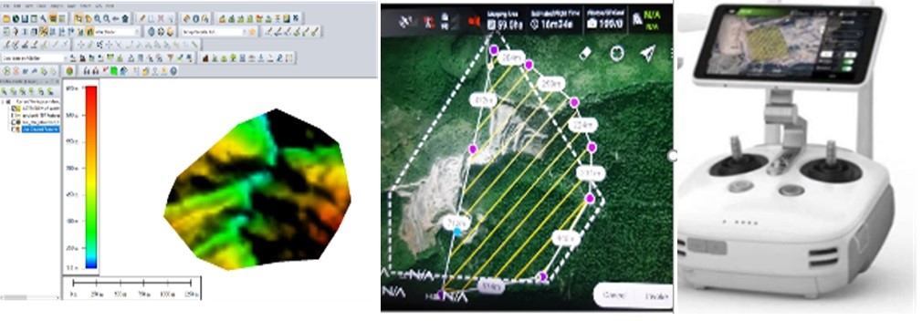
The flight planning process was created with the DJI GS RTK application from the control of the DJI Phantom 4 RTK system. In this context, firstly, DEM data was obtained in Global Mapper software for the study area. A flight plan was prepared by transferring the DEM data of the site and vector data (in KML format) covering the boundaries of the flight area to the controller via SD card (Figure 4). Then, using these data, adaptive flight planning was carried out depending on the size of the area and the battery capacity of the UAV.

Using the DJI Phantom 4 RTK UAV system with the PPK application module, two flights were performed in PPK mode in a quarry, which is an open mining area. PPK mode was chosen because the area is mountainous, and RTK mode avoids data loss due to satellite errors. The images taken within this scope were planned to have 60% front and 70% side overlap ratios and a flight height of 150 m. The CHCN X91 GNSS receiver was used as a solution for PPK static measurement positioning. When the UAV was in the air in PPK mode, the Rover observation file “Rinex.obs” (RINEX observation data) was saved directly to the SD memory card. The GNSS receiver was fixed with a tripod at a location with known coordinates, and the measurement was started in static mode at an antenna height of 200 cm. Since RINEX observation data should cover the entire flight, static data acquisition was performed for 15 minutes before and 15 minutes after the UAV flight, for a total of 30 minutes excluding the flight time. The static data is stored in the internal memory of the GNSS receiver in a special file format, “.HCN.”.
Processing of digital images taken by UAV
After the flights were completed, Agisoft Metashape Professional Version 1.5.2 software was used to process the images taken by the UAV and produce point cloud, DEM, and orthophoto images with high resolution and accuracy (Agisoft, 2022). The software was run on the Windows 10 64-bit operating system. The accuracy level of the image orientation process was set as medium, and the quality settings were selected as high for the other depth maps and dense cloud production stages. The outputs of the photogrammetric analysis of the images are DEMs and orthomosaics in “tiff” format. Correction of camera positions for images taken in PPK mode was performed using CHC Geomatics Office 2 software. “PPKRAW” files for rover and base observation files and “HCN” files for GNSS base station were imported into the software, and the corrected camera positions were saved as a CSV file after processing. The corrected camera positions saved as CSV were replaced with the uncorrected camera positions in Agisoft Metashape software, and the PPK data were analyzed and balanced orthomosaic and DEM were produced (Figure 5).
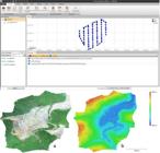
Correction of image positions in CHC Geomatics Office 2 PPK levelling software and reconstructed: a) orthophoto image, b) DEM.
Measurement of Slope Step Geometry in Open-Pit Mining Rehabilitation
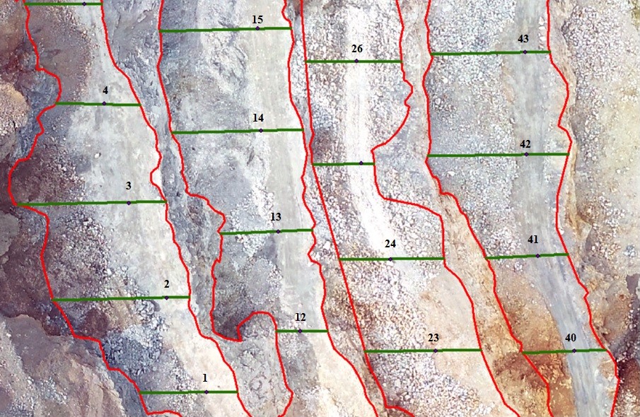
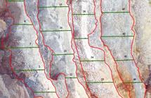
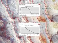
In the rehabilitation of quarries under the control of the public administration, it is checked whether there is a violation of the boundaries of the operation area and whether the width, height, and angles of the slope steps are made according to the contract. Therefore, the quarry boundaries, slope width, height, and angle were determined from the orthophoto and DEM data obtained. Slope geometry measurements vary depending on the purpose of rehabilitation of the sites disturbed as a result of mining activities. For example, if the mine site will be used as a forest after the operation, the slope width and height should be maximum 10 m and the slope angle should be maximum 75°. If it is to be used for recreational purposes, the slope height cannot be more than 3 m, the slope width cannot be less than 5 m, and the slope angle cannot be greater than 30° (RTOG, 2010). In this study, rehabilitation works as a result of open-pit mining activities are aimed to be used as forest. First- and second flight orthophoto images were used to trace the quarry boundaries, and its boundaries were digitized with polygon vector data created in ArcGIS 10.3 software. In the measurement of the width of the slope step of the quarry, using the point vector data created in the same way, a point was placed every 20 meters on each slope step and digitized using line vector data over these points, and the values were obtained from the attribute data (Figure 6). For the height measurements of the slope steps, the height values of each step were calculated by using orthophoto and DEM data by using the ArcGIS software Interpolate Line interface over each point. The difference between the highest and lowest values was determined as slope height (Figure 7). In addition, in measuring the slope angles, the height (y2-y1) and width (x2-x1) values at each point of the slope were entered into the slope formula (m=(y2-y1) / (x2-x1) * 100), and then 1° was accepted as approximately 2.2%, and the percentage slopes found with this coefficient were converted into degrees, and calculations were made.
RESULTS
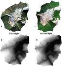
Photogrammetric products (orthophotos and DEMs) that evaluate both horizontal (X and Y) and vertical (Z) position accuracies were created with the images obtained from PPK flights. When the location error estimates of all cameras in the orthophoto images generated as a result of the PPK method are analyzed, the total average camera location error after PPK balancing solution is calculated as 0.7 cm. This value is better than the UAV-based RTK total average camera position error. Figure 8 shows the orthophotos and DEMs of the flights. When the orthophotos and DEMs are analyzed, the change in the open-pit mining slopes during the 7-month period can be easily seen.
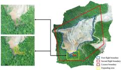
The area of the quarry was 106390 m² with a surrounding area of 1869 m in the first flight and 107434 m² with a surrounding area of 1894 m in the second flight. In a period of approximately 7 months, the quarry area has expanded by 1044 m², its perimeter by 25 m, and the slope grade has increased. Production work has not yet started in the expanded section, and the forest trees in this section have been cut and made ready for operation. The boundary coordinates of the quarry permit area were transferred on the orthophoto obtained from the last flight (Figure 9). It was determined that there was no violation of the quarry boundary. It is understood that with this method, permission boundary coordinates can be easily checked.
According to the results of the first flight data, the maximum, minimum, and average slope width, height, and angles of the quarry slope step width, height, and angles are 16.46 m, 3.31 m, and 7.39 m, respectively. The maximum, minimum, and average slope heights were 17.88 m, 4.10 m, and 12.45 m, respectively. In addition, the maximum, minimum, and average slope angle values were 136.76°, 43.62°, and 83.46°, respectively. According to the second flight data results, the maximum, minimum, and average slope width values of the quarry slope step width, height, and angles were 29.45 m, 4.67 m, and 16.09 m, respectively. The maximum, minimum, and average slope height values were 23.05 m, 2.09 m, and 13.33 m, respectively. In addition, the maximum, minimum, and average slope angle values were 78.27°, 12.33°, and 40.48°, respectively (Table 1). In their contract with the public administration, the quarry operator committed to a slope width and height of 10 meters each and a maximum slope angle of 75°. The results obtained do not match with the values in the commitment given by the quarry operator. In this case, the public administration makes the necessary warnings.
DISCUSSION
In the literature, studies on the use of UAV systems in quarry rehabilitation studies are limited. Studies are generally related to material calculation and photogrammetric verification.
In the study, the total average camera position error after the PPK balancing solution was calculated as 0.7 cm. This value is better than the UAV-based RTK total average camera position accuracy. In the studies carried out, it has been observed that the most accurate photogrammetric products required in forestry, etc. studies can be obtained with this approach without the use of UAV systems (Tomaštík et al., 2019; Türk and Öcalan, 2020). Türk et al. (2022) reported that the average camera position accuracies determined by RTK and PPK methods on orthophotos were 2.5 cm and 0.8 cm, respectively, and that more accurate measurements were obtained with the PPK method.
In the study, the open-pit mining was monitored for 7 months and spatial changes were easily detected. In addition, the width, height and angles of the quarry slope step were easily measured from the UAV system data. In many areas, ground changes have been tried to be determined by using UAV systems. Ambrosia et al. (2011) and Hinkley and Zajkowski (2011) revealed the change by mapping forest fires in their studies. In another study, Fladeland et al. (2011) monitored polar sea ice. Furthermore, Eker et al. (2018) monitored and analysed active landslides. It is also used for the study of invasive species (Hardin et al., 2007), grassland mapping (Breckenridge and Dakins, 2011; Laliberte et al., 2011; Laliberte and Rango, 2011), hydrology and riparian practices (Hervouet et al., 2011) and precision agriculture (Hunt et al., 2010).
CONCLUSIONS
In this study, slope geometry was measured, and control of boundary violations was investigated by using the UAV-based PPK method in the rehabilitation process of open-pit mining sites (quarries). The average camera position accuracy determined on the orthophoto by the PPK method in the study area was 0.7 cm. The slope geometry of the open quarry in the rehabilitation process was easily measured, and some of the results found did not comply with the terms of the contract between the public administration and the owner. By using the UAV-based PPK method in rugged and hard-to-reach areas such as quarries, possible data loss was prevented. The public administration’s use of UAVs in the control of rehabilitation works during and after the activities of the open quarry provides significant advantages in terms of labor, occupational safety, time, and control. More precise results were obtained by using the PPK method in the controls performed with the UAV. Since UAV inspections are easier and faster than traditional methods, open-pit mining sites can be inspected more frequently in shorter periods. These controls will facilitate boundary monitoring and slope geometry monitoring and measurement.
REFERENCES
-
AKGÜL, M.; YURTSEVEN, H.; DEMIR, M.; et al. Usage opportunities of generating digital elevation model with unmanned aerial vehicles on forestry. FORESTIST, v. 66, n. 1, p. 104-118, 2016. https://doi.org/10.17099/jffiu.23976
» https://doi.org/10.17099/jffiu.23976 -
AMBROSIA, V. G.; WEGENER, S.; ZAJKOWSKI, T.; et al The Ikhana unmanned airborne system (UAS) western states fire imaging missions: From concept to reality (2006-2010). Geocarto International, v. 26, 85-101, 2011. https://doi.org/10.1080/10106049.2010.539302
» https://doi.org/10.1080/10106049.2010.539302 -
AGISOFT. Agisoft metashape user manual: professional edition, version 1.7. https://www.agisoft.com/pdf/metashape_1_7_en.pdf Accessed in: 27.05.2021.
» https://www.agisoft.com/pdf/metashape_1_7_en.pdf - BANGIAN, A. H.; ATAEI, M.; SAYADI, A. et al. Optimizing post-mining land use for pit area in open-pit mining using fuzzy decision making method. International journal of Environmental Science and Technology, v. 9, n. 4, p. 613-628 , 2012.
-
BRECKENRIDGE, R. P.; DAKINS, M. E. Evaluation of bare ground on rangelands using Unmanned Aerial Vehicles: A case study. GIScience & Remote Sensing, v. 48, n. 1, p. 74-85, 2011. https://doi.org/10.2747/1548-1603.48.1.74
» https://doi.org/10.2747/1548-1603.48.1.74 -
CANH, V.L.; CUONG, X. C.; VIET, H. L.; et al. Volume computation of quarries in vietnam based on unmanned aerial vehicle (UAV) data. Journal of Mining and Earth Sciences, v. 61, n. 1, p. 21-30, 2020. https://doi.org/10.46326/JMES.2020.61(1).03
» https://doi.org/10.46326/JMES.2020.61(1).03 -
CARABASSA, V.; ORTIZ, O.; ALCAÑIZ, J.M. RESTOQUARRY: Indicators for self-evaluation of ecological restoration in open-pit mines. Ecological Indicators, n.102, p. 437-445, 2019. https://doi.org/10.1016/j.ecolind.2019.03.001
» https://doi.org/10.1016/j.ecolind.2019.03.001 -
CHEN, W.; LI, X.; HE, H.; et al. A review of fine-scale land use and land cover classification in open-pit mining areas by remote sensing techniques. Remote Sensing, v. 10, n. 15, p. 1-19, 2018. https://doi.org/10.3390/rs10010015
» https://doi.org/10.3390/rs10010015 -
COLOMINA, I.; MOLINA, P. Unmanned aerial systems for photogrammetry and remote sensing: a review. Journal of Photogrammetry and Remote Sensing, n. 92, p. 79-97. 2014. https://ui.adsabs.harvard.edu/link_gateway/2014JPRS...92...79C/ https://doi.org/10.1016/j.isprsjprs.2014.02.013
» https://ui.adsabs.harvard.edu/link_gateway/2014JPRS...92...79C/» https://doi.org/10.1016/j.isprsjprs.2014.02.013 -
EKER, R.; AYDIN, A.; HÜBL, J. Unmanned aerial vehicle (UAV)-based monitoring of a landslide: Gallenzerkogel landslide (Ybbs-Lower Austria) case study. Environ Monit Assess, v.190, n. 28, p. 1-14, 2018. https://doi.org/10.1007/s10661-017-6402-8
» https://doi.org/10.1007/s10661-017-6402-8 -
EKER, R.; ALKAN, E.; AYDIN, A. A comparative analysis of uav-rtk and uav-ppk methods in mapping different surface types. European Journal of Forest Engineering, v. 7, n. 1, p. 12-25, 2021. https://doi.org/10.33904/ejfe.938067
» https://doi.org/10.33904/ejfe.938067 -
ESPINOZA, D.; GOYCOOLEA, M.; MORENO, E.; et al. MineLib: a library of open pit mining problems. Annals of Operations Research, n. 206, p. 93-114, 2013. https://doi.org/10.1007/s10479-012-1258-3
» https://doi.org/10.1007/s10479-012-1258-3 -
FESTIN, E. S.; TIGABU, M.; CHILESHE, M. N.; et al. Progresses in restoration of post-mining landscape in Africa. Journal of Forestry Research, v. 30, p. 381-396, 2019. https://doi.org/10.1007/s11676-018-0621-x
» https://doi.org/10.1007/s11676-018-0621-x -
FLADELAND, M.; SUMICH, M.; LOBITZ, B.; et al. The NASA SIERRA science demonstration programme and the role of small-medium unmanned aircraft for earth science investigations. Geocarto International, v. 26, n. 2, p. 157-163, 2011. https://doi.org/10.1080/10106049.2010.537375
» https://doi.org/10.1080/10106049.2010.537375 -
GANN, G.D.; MCDONALD, T.; WALDER, B.; et al. International principles and standards for the practice of ecological restoration. Restoration Ecology, v. 27, p. 1-46, 2019. https://doi.org/10.1111/rec.13035
» https://doi.org/10.1111/rec.13035 -
GÜL, Y. Applications of unmanned aerial vehicle (UAV) in open-pit mines. Geological Bulletin of Turkey, v. 62, n 1, p. 99-112, 2019. https://doi.org/10.25288/tjb.519506
» https://doi.org/10.25288/tjb.519506 -
HARDIN, P. J.; JACKSON, M. W.; ANDERSON, V. J.; et al. Detecting squarrose knapweed (Centaurea virgata Lam. Ssp. squarrosa Gugl.) using a remotely piloted vehicle: a Utah case study, GIScience & Remote Sensing, v. 44, n. 3, p. 203-219, 2007. https://doi.org/10.2747/1548-1603.44.3.203
» https://doi.org/10.2747/1548-1603.44.3.203 - HERVOUET, A.; DUNFORD, R.; PIÉGAY, H.; et al. Analysis of post-flood recruitment patterns in braided-channel rivers at multiple scales based on an image series collected by unmanned aerial vehicles, ultra-light aerial vehicles, and satellites. GIScience & Remote Sensing, v. 48, n. 1, p. 50-73, 2011.
-
HINKLEY, E. A.; ZAJKOWSKI, T. USDA forest service-NASA: unmanned aerial systems demonstrations-pushing the leading edge in fire mapping. Geocarto International, v. 26, n. 2, p. 103-111, 2011. https://doi.org/10.1080/10106049.2011.555823
» https://doi.org/10.1080/10106049.2011.555823 -
HUNT, E. R.; HIVELY, W. D.; FUJIKAWA, S.; et al. Acquisition of NIR-green-blue digital photographs from unmanned aircraft for crop monitoring. Remote Sensing, v. 2, n. 1, p. 290-305, 2010. https://doi.org/10.3390/rs2010290
» https://doi.org/10.3390/rs2010290 -
KABADAYI, A.; UYSAL, M. Detection of buildings from data obtained by unmanned aerial vehicle. Turkish Journal of Unmanned Aerial Vehicles, v. 1, n. 1, p. 8-14, 2019. https://dergipark.org.tr/tr/download/article-file/891101
» https://dergipark.org.tr/tr/download/article-file/891101 -
KALAYCI, M.; UZUN, O. Recreational purpose evaluation of mine areas after mining. Journal of The International scientific Researches, v. 2, n. 2, p. 232-244, 2017. https://dergipark.org.tr/tr/download/article-file/334626
» https://dergipark.org.tr/tr/download/article-file/334626 -
KUN, M.; ÖZCAN, B. Usage of unmanned aircraft in mining quarries: a sample field study. J. BAUN Inst. Sci. Technol., v. 21, n. 2, p. 554-564, 2019. https://doi.org/10.25092/baunfbed.624484
» https://doi.org/10.25092/baunfbed.624484 -
LALIBERTE, A. S.; WINTERS, C.; RANGO, A. UAS remote sensing missions for rangeland applications. Geocarto International, v. 26, n. 2, p. 141-156, 2011. https://doi.org/10.1080/10106049.2010.534557
» https://doi.org/10.1080/10106049.2010.534557 -
LALIBERTE, A.S.; RANGO, A. Image processing and classification procedures for analysis of sub-decimeter imagery acquired with an unmanned aircraft over arid rangelands. GIScience & Remote Sensing, v. 48, n. 1, p. 4-23, 2011. https://doi.org/10.2747/1548-1603.48.1.4
» https://doi.org/10.2747/1548-1603.48.1.4 -
MACDONALD, S. E.; LANDHAUSSER, S. M.; SKOUSEN, J.; et al. Forest restoration following surface mining disturbance: challenges and solutions. New Forests, v. 46, p. 703-732, 2015. https://doi.org/10.1007/s11056-015-9506-4
» https://doi.org/10.1007/s11056-015-9506-4 -
MCKENNA, P. B.; LECHNER, A. M.; PHINN, S.; et al. Remote sensing of mine site rehabilitation for ecological outcomes: a global systematic review. Remote Sensing, v. 12, n. 21, p.3535, 2020. https://doi.org/10.3390/rs12213535
» https://doi.org/10.3390/rs12213535 -
MEUCC. Ministry of Environment, Urbanisation and Climate Change, mining activities sectoral implementation guide, Ankara/Turkey, 2020. 15p. https://cevresehiriklimkutuphanesi.csb.gov.tr/ShowPDF/17daab52-13ae-4cff-ac37-e9ec5498ff0a
» https://cevresehiriklimkutuphanesi.csb.gov.tr/ShowPDF/17daab52-13ae-4cff-ac37-e9ec5498ff0a -
ÖZGENOĞLU, A. Approaches for slope stability analysis in mining. Mining, v. 25, n. 1, p. 17-27, 1986. https://dergipark.org.tr/tr/download/article-file/376347
» https://dergipark.org.tr/tr/download/article-file/376347 -
ÖZŞAHIN, E.; SARI, H.; EROĞLU, İ. Environmental effects of spatiotemporal change in quarries in Naip plain and its surroundings (Tekirdag). Yuzuncu Yıl University Journal of Agricultural Sciences, v. 28, n. 3, p. 331-344, 2018. https://doi.org/10.29133/yyutbd.426399
» https://doi.org/10.29133/yyutbd.426399 - PRATIWI, P. ; NARENDRA, B. H.; SIREGAR, C. A.; et al. Managing and reforesting degraded post-mining landscape in Indonesia: a review. Land, v. 10, n. 6, p. 658, 2021.
-
RAEVA, P. L.; FILIPOVA, S. L.; FILIPOV, D. G. Volume computation of a stockpile-a study case comparing gps and uav measurements in an open pit quarry. The International Archives of the Photogrammetry, Remote Sensing and Spatial Information Sciences, v. 41, p. 999-1004, 2016. https://doi.org/10.5194/isprs-archives-XLI-B1-999-2016
» https://doi.org/10.5194/isprs-archives-XLI-B1-999-2016 -
REHAK, M.; MABILLARD, R.; SKALOUD, J. A micro-UAV with the capability of direct georeferencing. The International Archives of the Photogrammetry, Remote Sensing and Spatial Information Sciences, v. 40, p. 317-323, 2013. https://doi.org/10.5194/isprsarchives-XL-1-W2-317-2013
» https://doi.org/10.5194/isprsarchives-XL-1-W2-317-2013 -
REN, H.; ZHAO, Y.; XIAO, W.; et al. A review of UAV monitoring in mining areas: current status and future perspectives. International Journal of Coal Science and Technology, v. 6, n. 3, p. 320-333, 2019. https://doi.org/10.1007/s40789-019-00264-5
» https://doi.org/10.1007/s40789-019-00264-5 -
REPUBLIC OF TÜRKIYE OFFICIAL GAZETTE. By-law on the reintroduction of lands disturbed by mining activities to nature. Available at: Available at: https://www.resmigazete.gov.tr/eskiler/2010/01/20100123-1.htm Accessed in: January 10th 2010.
» https://www.resmigazete.gov.tr/eskiler/2010/01/20100123-1.htm -
TADDIA, Y.; STECCHI, F.; PELLEGRINELLI, A. Coastal mapping using DJI phantom 4 RTK in post-processing kinematic mode. Drones, v. 4, n. 2, p. 9, 2020. https://doi.org/10.3390/drones4020009
» https://doi.org/10.3390/drones4020009 -
TERCAN, E. Use of unmanned aerial vehicles in roadway measurements: Okurcalar City Center example. Omer Halisdemir University Journal of Engineering Sciences, v. 7, n. 2, p. 649-660, 2018. https://doi.org/10.28948/ngumuh.404265
» https://doi.org/10.28948/ngumuh.404265 -
TOMAŠTÍK, J.; MOKROŠ, M.; SUROVÝ, P.; et al. UAV RTK/PPK method-an optimal solution for mapping inaccessible forested areas? Remote Sensing, v. 11, n. 6, p. 1-19, 2019. https://doi.org/10.3390/rs11060721
» https://doi.org/10.3390/rs11060721 - TOPAY, M.; SERKAYA, A.; KOÇAN, N. The impacts of quarries on landscape and suggestions for their reusage: case study of Bartın. Journal of Suleyman Demirel University Faculty of Forestry, v. Ai, n. 2, p. 134-144, 2007.
-
TUCCI, G.; GEBBIA, A.; CONTI, A.; et al. Monitoring and computation of the volumes of stockpiles of bulk material by means of uav photog-rammetric surveying. Remote Sensing, v. 11, n. 12, 1471, 2019. https://doi.org/10.3390/rs11121471
» https://doi.org/10.3390/rs11121471 -
TÜRK, Y.; BALABAN, B.; ALKAN, E. The use of UAV-based RTK/PPK method in monitoring the ground change after excavation in open-pit mine sites: A case study in the Düzce-Tatlıdere quarry. Turkish Journal of Forestry Research, v. 9, n. special, p.76-85, 2022. https://doi.org/10.17568/ogmoad.1093694
» https://doi.org/10.17568/ogmoad.1093694 -
TÜRK, Y.; CANYURT, H.; EKER, R.; et al. Determination of forest road cut and fill volumes by using un-manned aerial vehicle: a case study in the Bolu-Taşlıyayla. Turkish Journal of Forestry Research, Special Issue, p. 97-104, 2022. https://doi.org/10.17568/ogmoad.1093695
» https://doi.org/10.17568/ogmoad.1093695 -
TÜRK, Y.; BALABAN, B. Determination of excavation volume using uav-based ppk method in open mining sites Tatlıdere Forests in Düzce. Düzce University Journal of Science and Technology, v. 13, n. 1, p. 443-455, 2025. https://doi.org/10.29130/dubited.1515664
» https://doi.org/10.29130/dubited.1515664 -
TÜRK, T.; ÖCALAN, T. Examining the accuracy of photogrammetric products obtained by unmanned aerial vehicles having PPK GNSS system with different approaches. Photogrammetry Journal of Turkey, v. 2, n. 1, p. 22-28, 2020. https://dergipark.org.tr/tr/pub/tufod/issue/53476/693407
» https://dergipark.org.tr/tr/pub/tufod/issue/53476/693407 - TÜRK, Y.; ÖZÇELIK, V.; AKDUMAN, E. Capabilities of using UAVs and close range photogrammetry to determine short-term soil losses in forest road cut slopes in semi-arid mountainous areas. Environ. Monit. Assess., v.196, p.. 149, 2024.
-
ULUSOY, Y.; AYAŞLIGİL, T. A Study about recycling into the nature and the rehabilitation of open pit mines through “Şile-Avcıkoru” sample case. Journal of the Faculty of Forestry, Istanbul University, v. 62, n. 2, p. 21-26, 2012. https://dergipark.org.tr/tr/download/article-file/175465
» https://dergipark.org.tr/tr/download/article-file/175465 -
ULVI, A. Analysis of the utility of the unmanned aerıal vehıcle (UAV) in volume calculation by using photogrammetric techniques. International Journal of Engineering and Geosciences, v. 3, n. 2, p. 43-49, 2018. https://doi.org/10.26833/ijeg.377080
» https://doi.org/10.26833/ijeg.377080 -
WATTS, A. C.; AMBROSIA, V. G.; HINKLEY, E. A. Unmanned aircraft systems in remote sensing and scientific research: Classification and considerations of use. Remote Sensing, v. 4, n. 6, p. 1671-1692, 2012. https://doi.org/10.3390/rs4061671
» https://doi.org/10.3390/rs4061671 - WBCSD. World Business Council for Sustainable Development. Guidelines on quarry rehabilitation, 2019, 32p.
-
ZHU, D., CHEN, T.; ZHEN, N.; et al. Monitoring the effects of open-pit mining on the eco-environment using a moving window-based remote sensing ecological index. Environmental Science and Pollution Research, v. 27. p. 15716-15728, 2020. https://doi.org/10.1007/s11356-020-08054-2
» https://doi.org/10.1007/s11356-020-08054-2 -
ZIPPER, C. E.; BURGER, J. A.; SKOUSEN, J. G.; et al. Restoring forests and associated ecosystem services on appalachian coal surface mines. Environmental Management, v. 47, p. 751-765, 2011. https://doi.org/10.1007/s00267-011-9670-z
» https://doi.org/10.1007/s00267-011-9670-z
-
Scientific Editor:
Luciano Cavalcante de Jesus França