 Herbicide deposition and effective weed control achieved through optimized unmanned aerial vehicle flight height with DJI AGRAS T10
ABSTRACT
The use of unmanned aerial vehicles (UAVs) in agricultural spraying is growing globally, but few studies exist on spray deposition of herbicides, such as glyphosate, and weed control efficacy in pre-sowing burndown. This study sought to evaluate the deposition of glyphosate, tracer, and the effectiveness of ryegrass control at different application heights with DJI Agras T10. Carried out in a winter fallow area with a predominantly ryegrass infestation, originating from natural sowing, the experiment was conducted in a completely randomized design, in a 4x7+1 factorial arrangement, evaluating flight heights of 3, 4, 5, and 6 m and, in the second factor, 7 evaluation points every 1m to measure spray deposition, with 5 replications and a total of 35 plots. The application mixture included glyphosate (1.25 kg ae ha−1), clethodim (0.12 kg ai ha−1), and the dye tracer Brilliant Blue (3g L−1). The deposited mixture was recovered and quantified through spectrophotometry. Increasing the flight height resulted in less application uniformity and lower glyphosate deposition, due to spray drift outside the experimental area, which impaired the effectiveness of burndown. However, application at 3 m provided greater deposition and uniform distribution along the strip evaluated. Tracer solution deposition was lower at heights of 3 and 4 m, with minimal variation at 7 m range. A height of 3 m was the best of the tested heights for burndown, ensuring uniform glyphosate and clethodim deposition and weed control of >90%.
Index terms:
Lolium multiflorum; glyphosate; clethodim; application heights
RESUMO
O uso de veículos aéreos não tripulados (VANTs) na pulverização agrícola tem crescido globalmente, embora ainda existam poucos estudos sobre a deposição de herbicidas, como o glyphosate, e sobre a eficácia do controle de plantas daninhas na dessecação pré-semeadura. Este estudo teve como objetivo avaliar a deposição de glyphosate e de um traçador, bem como a eficácia do controle de azevém, em diferentes alturas de aplicação utilizando o DJI Agras T10. O experimento foi realizado em área de pousio de inverno, com infestação predominante de azevém, em delineamento inteiramente casualizado, no arranjo fatorial 4×7+1. Testaram-se alturas de voo de 3, 4, 5 e 6 m e sete pontos de avaliação espaçados a cada 1 m para quantificação da deposição, totalizando 35 parcelas com cinco repetições. A calda incluía glyphosate (1,25 kg ea ha-¹), clethodim (0,12 kg ia ha-¹) e o corante azul brilhante (3 g L⁻¹). A mistura depositada foi quantificada através de espectrofotometria. O aumento da altura de voo reduziu a uniformidade e a quantidade de deposição devido ao maior desvio do spray para fora da área alvo, comprometendo a eficácia da dessecação. Em contraste, a aplicação a 3 m apresentou maior deposição e melhor distribuição ao longo da faixa avaliada. A deposição do traçador também foi menor nas alturas de 3 e 4 m, porém com menor variação dentro da faixa de 7 m. Entre as alturas testadas, 3 m apresentou o melhor desempenho, garantindo deposição uniforme de glyphosate e resultando em controle superior a 90% de azevém.
Termos para indexação:
Lolium multiflorum; glyphosate; clethodim; alturas de aplicação
Introduction
The use of cover crops during the off-season provides several agroecological benefits, such as reducing soil erosion and nitrogen leaching, increasing nutrient cycling, and suppressing weeds (Silva et al., 2024). However, for the efficient implementation of the no-till system, these plants must be properly managed to avoid interference with the development of the main crop. In this context, the application of herbicides before sowing, a practice known as desiccation management, has become a fundamental step for the success of direct seeding (Procópio et al., 2006). When desiccation is inefficient, many weeds can establish themselves in the area, competing with the crop for nutrients, light, water, and space (Ramos et al., 2019). Therefore, controlling cover crops and the weed community before sowing allows the crop to develop free from early interference, mitigates regrowth and reinfestations, and facilitates complementary management after emergence (Timossi, Durigan & Leite, 2006). Efficient desiccation is thus a decisive factor for the success of conservation systems such as no-till farming (Jaremtchuk et al., 2008).
Among the most widely used herbicides in this context, glyphosate stands out because it inhibits essential physiological pathways for plant growth, resulting in plant death (Bajwa, 2014). Glyphosate revolutionized weed management in agricultural crops, becoming the main herbicide used to control cover crops before sowing (Duke, 2011). It is a non-selective, broad-spectrum herbicide that acts as an analog of the transition state of phosphoenolpyruvate in the shikimic acid pathway, inhibiting the enzyme 5-enolpyruvylshikimate-3-phosphate synthase (EPSPs) (Duke & Powles, 2008). In the no-till system, the use of non-selective herbicides such as glyphosate is indispensable, as they provide broad-spectrum control without leaving residual activity in the soil (Timossi et al., 2016). Although integrated weed management (IWM) is essential for sustainability and productivity, chemical control remains the main strategy in large-scale systems for suppressing cover crops and establishing grain crops (Timossi, Durigan & Leite, 2006).
There are different methods of herbicide application, including manual equipment, tractor-mounted systems, and aerial spraying (Silva Neto, Sasaki & Alvarenga, 2021). Recently, unmanned aerial vehicles (UAVs) have gained prominence in agriculture, in addition to uses in photogrammetry, mapping, disaster monitoring, and military applications (Chaurasia & Mohindru, 2021; Mohsan et al., 2023). In agriculture, UAVs are increasingly used, especially in weed control, due to their potential for precision and efficiency (Radoglou-Grammatikis et al., 2020).
Spraying with UAVs presents significant advantages: uniform speed regardless of topography, easier treatment of tall crops (e.g., forests, fruit trees, and corn), better performance in waterlogged soils, lower water consumption, reduced operator exposure, less environmental contamination, elimination of soil compaction, and reduced crop damage, in addition to enabling applications with low spray volumes. However, limitations include the need for specialized operators, low payload capacity, restricted battery autonomy, and a higher risk of drift at greater flight altitudes, which can compromise selectivity and affect non-target organisms (Gugan & Haque, 2023; Yan et al., 2016).
Beyond spraying, UAVs allow for greater precision in mapping infested areas, optimizing herbicide use, reducing waste and operational costs (Umeda, Yoshikawa & Seo, 2022), supporting more accurate agronomic decisions and sustainable management. Brazil is internationally recognized as a pioneer in the adoption of agricultural drones, with established use in crops such as pastures, sugarcane, corn, and soybeans (Sindag, 2025). In these contexts, UAVs have been used for pest monitoring, nutritional diagnosis through thermal or spectral imaging, and geospatial surveys (Ahirwar et al., 2019; Dutta & Goswami, 2020).
Nevertheless, UAV spraying technology still requires studies that validate its effectiveness under field conditions (Oliveira et al., 2020). Application efficacy depends not only on flight height but also on the uniformity of droplet deposition along the spray swath, a key parameter for evaluating process quality. Studies on crops such as corn, sugarcane, and vineyards demonstrate a negative correlation between flight height and deposition (Cunha & Silva, 2023; Zhang et al., 2021; Delpuech et al., 2022). In this context, deposition uniformity is considered a crucial technical indicator for evaluating application efficiency (Chen et al., 2017).
Despite the rapid growth in UAV adoption in agriculture, little information exists regarding the uniformity of herbicide active ingredient deposition in aerial spraying with drones. Based on the hypothesis that flight height can influence application uniformity across the spray swath, this study aimed to evaluate glyphosate deposition and its efficacy in controlling weeds at different application heights using UAVs.
Material and Methods
Experiment site
The experiment was conducted on the experimental farm of the Center for Agro-Veterinary Sciences, located in the municipality of Lages, in the state of Santa Catarina (27°45’39.89” S and 50°04’57.05”W), during the 2023/24 harvest. The experimental area was located more than 20 meters away from the water body, in accordance with the provisions of Chapter III of MAPA Ordinance No. 298, dated September 22, 2021, which regulates the operational safety criteria for aerial applications (Brasil, 2021).
The soil of the Experimental Farm is classified as cambisol and was collected from the 0-20 cm depth layer, showing 34% clay. The soil has a pH (H2O) of 5.9; 3.10 cmolc dm-3 H+ + Al3+; 12.35 cmolc dm-3 Ca+2; 7.89 cmolc dm-3 Mg+2; 0.75 cmolc dm-3 K+; 15.0 mg dm-3 P; 3.8% organic matter; 87.13% base saturation.
In this cultivation area, only summer crops (soybean and corn) are sown, and during the off-season, green cover crops are sown or, in more severe cases, the area remains fallow (the scenario of this study). The herbicide was applied in a fallow area with a predominance of ryegrass (Lolium multiflorum with 5-8 tillers). The other major species that comprised the weed community were wild radish (Raphanus raphanistrum with 5-7 true leaves) and cobblers pegs (Bidens Pilosa with 8-12 true leaves), both species originating from the seed bank, identified with the help of a weed identification manual. All species were evenly distributed in the area and the infesting community was in the reproductive stage during the experiment. Ryegrass occurs in the area spontaneously due to natural reseeding (from the BRS Ponteio cultivar).
No studies have been conducted regarding the characterization of the degree of resistance or sensitivity of weed biotypes. However, it is suspected that the biotypes exhibit sensitivity to the herbicides glyphosate and clethodim, used in burndown.
Description of treatments
The experimental design used was completely randomized in a 4x7 factorial arrangement with the addition of a control without herbicide application, in which the first factor corresponds to application at 4 flight heights: 3, 4, 5, and 6 m. These flight heights are used in commercial areas to increase operational efficiency, as they allow for an expanded application range. The second factor evaluated consisted of 7 points in the range, equidistant by 1m. Therefore, the evaluated range corresponded to 7 meters, a dimension that ensures the operational efficiency of the drone model used, but it may compromise the quality of the application, a central aspect addressed in this work.
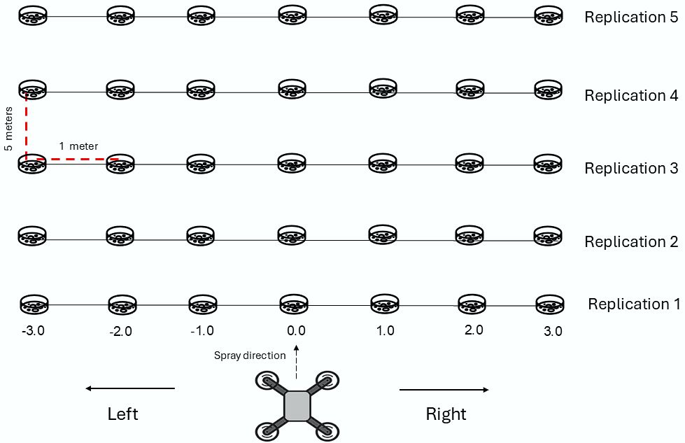
Each treatment consisted of 35 plots (seven plots per range, with 5 replications per evaluated band position), each plot was 1 m wide and 5 m long (5 m2). A petri dish (diameter 10 cm and rim height 2 cm) was placed in each experimental unit to collect the deposition of tracer and herbicide glyphosate from a known area to recover the deposited mixture. The application range was evaluated at 1-m intervals relative to the Petri dish (−3 m to +3 m), resulting in a total evaluation range of 7 m, as shown in Figure 1.

applications were carried out using the central position of the evaluation strip (0.0) as a reference point, where a negative value indicates plots on the left side and a positive value indicates plots on the right side, covering a total application strip of 7 m.
The treatments were applied on September 28, 2023, at 9 AM, and the measurements of climatic variables were taken at the beginning and end of the application, 1.8 m above the soil surface. Table 1 demonstrates the weather conditions at the time of application and the flight parameters used. DJI® Agras T10 UAV has a tank with a capacity of 8 L, treats 15 acres per hour, with a flow rate of 1.8 L min-1 with XR11001 nozzle, 3 to 5.5 m application range (at a height of 1.5-3 m above the canopy) (DJI, 2025).
The pre-sowing burndown mixture was made up of glyphosate - (1.25 kg acid equivalent N-phosphonomethyl glycine ha-1) - and, clethodim (0.12 kg active ingredient ha−1), and the tracer containing the food coloring Brilliant Blue (FD&C Blue n.1) at a concentration of 3g L−1. The concentration used was adapted from Alves, Cunha and Palladini (2014), as it allows for the intensification of absorbance and, consequently, enables the determination of concentration, in accordance with the Beer-Lambert Law. The herbicides doses applied in pre-sowing burndown follow label recommendations, which are adjusted based on the target weed species (L. multiflorum) and its growth stage.
The tank mix of clethodim and glyphosate is widely used in southern Brazil due to the combination of different mechanisms of action, which is essential for pre-emergence burndown of L. multiflorum in the reproductive stage.
The total experimental area for each height was 175 m². To avoid the risk of drift, spatial and temporal separation was adopted. The experimental area for each flight height was separated by a strip of 7 m x 35 m, while the distribution of the plates occurred after the completion of the previous application, in order to mitigate possible overestimations.
Deposition of glyphosate and tracer
After spraying, the petri dish containing the solution composed of the herbicides and tracer was collected in a plastic bag. Sample bags were secured with a sterile nylon double-knot closure to eliminate risk of external contamination and transported to the laboratory, where the spray mixture was recovered by washing. In the laboratory, 100 mL of distilled water was added to recover the broth. Next, it was shaken manually for 30 seconds. Immediately after, the solution was transferred to Falcon tubes.
The recovery of the analyte was not performed in this study due to the complexity of field conditions, which do not allow the controlled addition of standards or marker analytes directly onto the matrix without interfering with the natural conditions of the experiment. Furthermore, the evaluation aimed to measure the residues resulting from the actual application, reflecting the behavior of the compound under practical use conditions, which makes the performance of conventional recovery tests unfeasible.
The samples collected from each plate were stored in a freezer at -15°C (± 2) until their subsequent analysis. Three hours after application, the tracer was analyzed. Six months later, glyphosate was quantified from the spray solution recovered during petri dish washout. The quantification was carried out only for glyphosate, as the methodology used proves to be a versatile, practical, and low-cost alternative, dispensing with the use of sophisticated equipment and, therefore, favoring its applicability in different laboratories. Furthermore, the evaluation of the impacts of application height on widely used herbicides, such as glyphosate, constitutes one of the main focuses of this work.
Prior to the analyses, calibration curves were established for the tracer and for glyphosate by spectrophotometry, using an EnSpire microplate reader (PerkinElmer, USA). For the tracer, the standard curve was constructed at concentrations of 0.000000; 0.000125; 0.000250; 0.000500 and 0.001 g L-1, generating the linear equation y = 103.2x + 0.0019 (R² = 0.9724). The quantification was performed at 630 ɳm, according to the methodology validated by Alves, Cunha and Palladini (2014). In the case of glyphosate, the analysis was conducted at 570 ɳm, using N-phosphonomethylglycine (Glyphosate Pestanal®, Sigma-Aldrich) as the standard and following the protocol of Bhaskara and Nagaraja (2006). The calibration curve covered concentrations of 0, 1, 3, 7, 11, 15, and 20 µg mL-1, resulting in the equation y = 0.0061x + 0.0535 (R² = 0.9548). These curves allowed the conversion of absorbance values into mass (µg) and subsequently into deposition units (μL cm−2) through the known area of the petri dish, enabling the precise determination of tracer and herbicide concentrations in the collected samples.
Visual assessment of burndown efficiency
Visual evaluations of L. multiflorum control efficiency and general weed control (used to include the other two species that made up the weed community) were conducted 14 and 28 days after application (DAA) of the treatments. These were performed using a visual control scale of 0%-100%, where 0% represents no control and 100% plant death (SBCPD, 1995), based on visual control determined by 4 previously trained evaluators.
Data analysis
The data were subjected to analysis of variance (α = 5%) using SISVAR software (Ferreira, 2011) and, when significant, the variables were plotted as a function of application range for each flight height, using SigmaPlot® software (version 14.5, California, USA).
Interpolation of the variables
Tracer and glyphosate deposition data and weed control efficiency in each plot were interpolated using the inverse distance weighted (IDW) method using ArcGIS 10.8 software (California, USA). The IDW estimates the variable over space by weighting each of the closest “n” points, which is a function of the inverse of a power of distance, i.e., the closer the point to be estimated, the greater the weight assigned to the sampled point (Jimenez & Domecq, 2008).
Results and Discussion
Tacer solution deposition
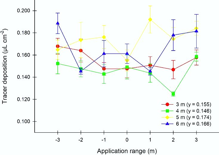
The interaction between the factors was not statistically significant, only for the main effects. Tracer solution deposition increased as the application was carried out at higher flight heights (Figure 2).
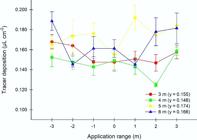
Tracer solution deposition (µL cm-2) as a function of application height for 3 m, 4 m, 5 m, and 6 m. The vertical bars in each symbol indicate the standard deviation of the mean (n = 5).
However, there was no uniformity of tracer solution deposition at flight heights of 5 and 6 m. At a height of 5 m, deposition ranged from 0.155 to 0.192 µL cm−2, with the highest values to the right of the strip at positions 1, 2, and 3 m. The height of 6 m gave the highest concentration of tracer at the edges of the strip, with 0.189 (left) and 0.182 µL cm−2 (right). Flights at 3 and 4 m gave similar average deposition concentrations, with 0.155 and 0.146 µL cm−2, respectively. UAV operation at a flight height of 3 m showed the greatest uniformity of tracer solution deposition, with a variation of only 5.4% in the application range. These results are in line with those of another study, which found that spray height had a significant effect on droplet deposition and, consequently, on the volume of spray per unit area (Shan et al., 2021). Average tracer solution deposition increased with height, but a reduction in average deposition was expected due to the weakening of the downwash effect in the Z direction, thereby negatively affecting spraying (Lan et al., 2021). However, this increase was caused by the accumulation at the edges of the strip, making weed control in the plots uneven.
Glyphosate deposition
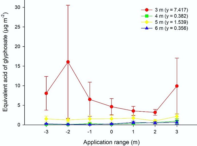
Flight height is a critical factor that influences deposition efficiency, especially for glyphosate, due to the significance of the flight height factor (Figure 3). The application carried out at a height of 3 m provided the highest total glyphosate deposition in the analyzed range, with an average accumulation of 51.92 µg m-2 and a variation of 52.81%. The higher rate of spray deposition per unit area was also observed in another study (Nascimento & Vitória, 2022), where spraying at a height of 3 m proved superior, contributing to a significant reduction in drift.

Deposition of equivalent acid of glyphosate (µg cm-2) as a function of application height for 3 m, 4 m, 5 m, and 6 m. The vertical bars in each symbol indicate the standard deviation of the mean (n = 5).
The application of glyphosate at 4, 5, and 6 meters resulted in 2.67, 10.77, and 2.49 µg m−2 (average accumulation), respectively, over the 7 m evaluated. An increase of 1 meter in height, from 3 to 4 m, reduced glyphosate deposition by 94.86%.
At a flight height of 5 m, the spray may have been greater due to spray drift, which caused a 2.4 times on the right side of the range (1, 2, and 3 m) and 97.29% of variation. The values observed on the right-hand side of the strip are probably due to drift at the time of application. This result corroborates other studies, which have found that UAV application generates a drift profile in inverse proportion to its height (Delpuech et al., 2022). Glyphosate deposition for the 4- and 6 m flights was uneven, varying by 182.13% and 165.09% respectively, with a low spray volume per unit area.
Poor uniformity of spray distribution can reduce the quality of the application, accelerate the evolution of resistance, and encourage overdosing (Shan et al., 2021). Homogeneous coverage generates uniform deposition with a low CV, as in the 3 m application used in this study. Conversely, a lack of uniformity in the strip can damage the crop, especially when spraying herbicides in which the quality of the application is responsible for weed control (Carvalho et al., 2020).
As demonstrated in Figures 2 and 3, the tracer and glyphosate exhibited distinct deposition patterns at all evaluated flight heights. Although tracers are widely used in deposition studies due to their detection facilitated by spectrophotometry, they have a limitation as they only indicate the presence or absence in the sample. Moreover, the biological activity is dependent on the active ingredient, that is, the quantification of glyphosate is indispensable to determine the magnitude of the effects triggered by different flight heights. In this study, methodological adaptations by Bhaskara and Nagaraja (2006) allowed for the direct quantification of glyphosate, revealing significant discrepancies compared to the tracer. This approach reinforces the need to validate tracers against the active ingredient, especially in aerial applications, where deposition is critical for agronomic efficacy and loss minimization.
Control evaluation
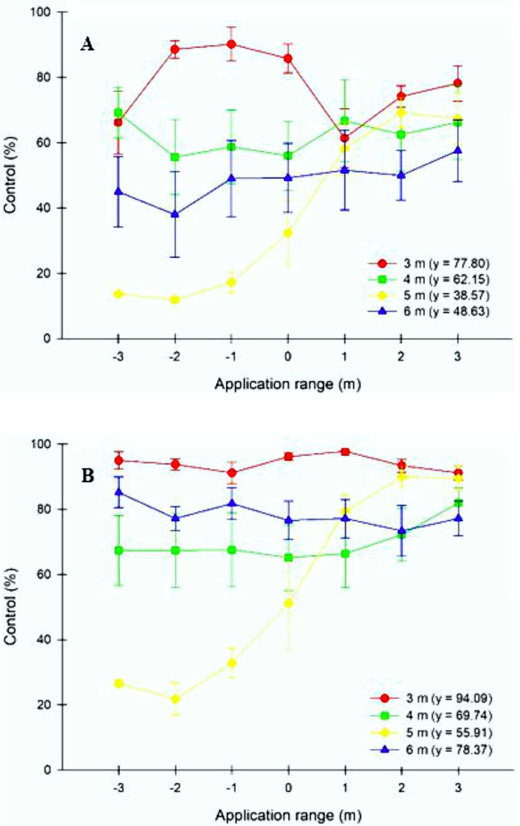
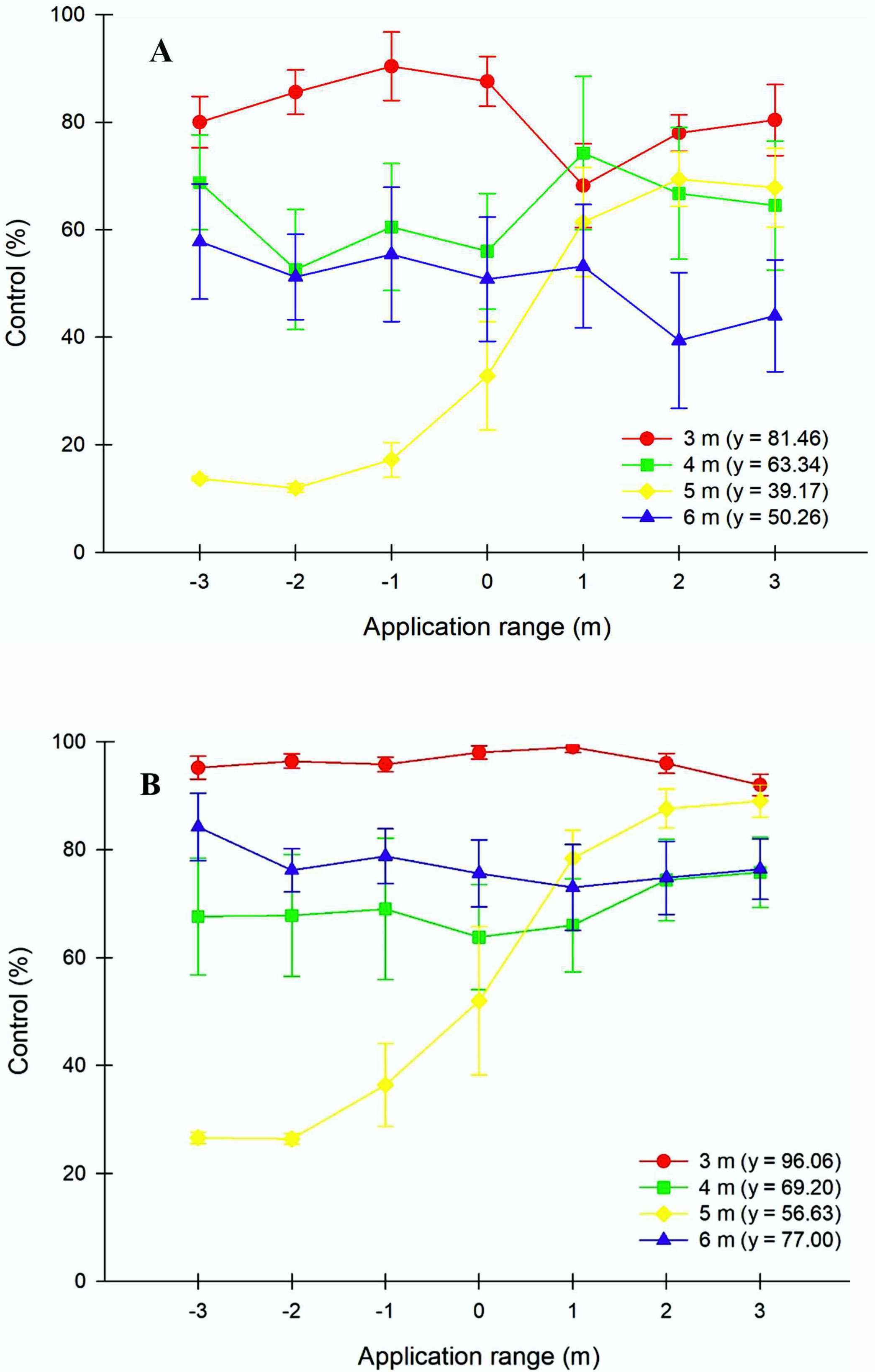
At 14 DAA, the application at a height of 3 m showed a maximum weed control of 90.20% and a minimum of 61.40% (Figure 4). In the evaluation at 28 DAA, this strip had an average control rate of 94.09%, with the lowest CV among the treatments evaluated, at 2.61%. This is because the mixture was deposited in greater quantities due to the higher concentration detected in the samples. The other treatments had lower spray depositions, resulting in less efficient burndown at 14 DAA. Systemic herbicides such as glyphosate and clethodim cause the plants to necrose slowly (Jaremtchuk et al., 2008). This herbicide characteristic led to an increase in the percentage of burndown at 28 DAA, where flight heights of 4, 5, and 6 m increased control by 7.59%, 17.34%, and 29.74%, respectively.
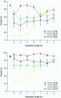
Visual control of weed community with the application of glyphosate and clethodim at flight heights of 3, 4, 5, and 6 m, at 14 (A) and 28 (B) days after application (DAA), as a percentage. The vertical bars in each symbol indicate the standard deviation of the mean (n = 5).
Based on the visual assessment of L. multiflorum control (Figure 5), burndown by the herbicide applied at 3 m of height was superior at 14 and 28 DAA, with ˃95% control at the end of the experiment. The lowest level of control in ryegrass burndown was obtained for the application height at 5 m, at 14 DAA, where the plots were classified qualitatively from no or poor control (<40.00%) to sufficient control (61.00%-70.00%), according to the Latin American Association of Weeds (SBCPD, 1995). These characteristics reflect the drift associated with flight height.
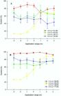
Visual control of Lolium multiflorum with the application of glyphosate and clethodim at flight heights of 3, 4, 5, and 6 m, at 14 (A) and 28 (B) days after application (DAA), as a percentage. The vertical bars in each symbol indicate the standard deviation of the mean (n = 5).
Figure 6 illustrates weed burndown among the treatments evaluated at 28 DAA. What stands out visually is the excellent control obtained when applied at a height of 3 m (>90.00%) due to the uniformity of deposition and the greater amount of glyphosate present on the plots. At a height of 4 m, control was close to 70.00%, but there were small unreached patches, especially in the final part of the experimental area, where weed control was regular (control 41-60%). In the plot that received the application at a height of 5 m, there remained a portion to the left of the evaluation strip with the lowest level of control (21.80%-32.80%), but the right side of the range, where endodrift occurred, had control of between 79.40% and 90.00%. Although the initial control (14 DAA) at 6 m (48.6%) was lower than that observed at 4 m (53.3%), the performance at 28 DAA at 6 m (78.4%) surpassed that at 4 m (69.7%), indicating a more effective late response at this flight height.
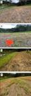
Weed burndown of the experimental area 28 days after the application of the phytosanitary solution as a function of flight height at 3 m (A), 4 m (B), 5 m (C), and 6 m (D).
Based on the burndown evaluation, the proper use of flight parameters, including flight height, directly affects the efficacy of weed control before the start of sowing since this parameter interferes with the width of deposition (Cunha et al., 2021). In aerial application, it is common to find deposition strips of different sizes, either very wide or narrow, which can cause variations in deposition (Carvalho et al., 2020).
Higher flight height increases the width of the application strip (Cunha & Silva, 2023), resulting in greater operational efficiency, i.e., a larger area receives the phytosanitary product application in a shorter space of time. On the other hand, the inadequate use of the correct flight height negatively affects the width of the application band, as it promotes low uniformity of deposition due to a reduction in the effect of the airflow, which projects the droplets toward the target, thus altering their deposition on the plant canopy, as observed in this study and others (Cunha et al., 2021). Therefore, using correct flight parameters, such as height and deposition range, are essential to ensure the spray reaches the target in adequate quantities and minimize loss to drift.
IDW interpolation
Figure 7 illustrates the maps produced, with information on weed control, glyphosate, and tracer solution deposition. It can be seen that flight height is directly related to the deposition of glyphosate and tracer and, consequently, the control assessed at 14 and 28 DAA. Visually, a flight height of 3 meters was ideal for burndown. The increase in flight height reduced herbicide deposition (acid equivalent mass) in the weed canopy and generally reduced the quality of burndown.
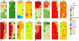
Spatial distribution of weed community control at 14 and 28 days after application (DAA), mass of glyphosate acid equivalent and tracer (µg) present on the Petri dish, as a function of application height at 3 m (A), 4 m (B), 5 m (C), and 6 m (D).
Conclusions
Raising flight height above 3 m increases drift risk and reduces burndown quality. Application at 3 m provided effective weed control, greater glyphosate deposition, and good uniformity. This height also ensured uniform tracer distribution, although deposition differed from glyphosate. Further studies should assess overlap, new drone technologies, and weather effects on application quality. The research offers guidance for maximizing herbicide efficiency with drones, emphasizing 3 m as ideal for deposition and control, while highlighting negative impacts of higher flight heights.
Acknowledgments
We thank the State University of Santa Catarina (UDESC) for the scientific support provided through the Institutional Research Scholarship Program (Programa Institucional de Bolsas de Iniciação Científica - PIBIC/UDESC). We also thank Dr. Caroline Aparecida Matias and MSc. Natacha Madruga Farias for her assistance with the analytical evaluations.
Data Availability Statement
Data available upon request to authors.
References
- Ahirwar, S. et al. (2019). Application of drone in agriculture. International Journal of Current Microbiology and Applied Sciences, 8(1):2500-2505.
- Alves, G. S., Cunha, J. P. A. R., & Palladini, L. A. (2014). Seleção de traçadores para estudos de eficiência das aplicações de produtos fitossanitários. Planta Daninha, 32(4):861-870.
- Bajwa, A. A. (2014). Sustainable weed management in conservation agriculture. Crop Protection, 12(65):105-113.
- Bhaskara, B. L., & Nagaraja, P. (2006). Direct sensitive spectrophotometric determination of glyphosate by using ninhydrin as a chromogenic reagent in formulations and environmental water samples. Helvetica Chimica Acta, 89(11):2686-2693.
-
Brasil. Ministério da Agricultura, Pecuária e Abastecimento (2021). Portaria MAPA nº 298, de 22 de setembro de 2021 Available in: <https://www.in.gov.br/en/web/dou/-/portaria-n-298-de-22-de-setembro-de-2021-336845666>.
» https://www.in.gov.br/en/web/dou/-/portaria-n-298-de-22-de-setembro-de-2021-336845666 - Carvalho, F. K. et al. (2020). Challenges of aircraft and drone spray applications. Outlooks on Pest Management, 31(2):83-88.
- Chaurasia, R., & Mohindru, V. (2021). Unmanned aerial vehicle (UAV): A comprehensive survey. In V. Mohindru et al. (Ed.). Unmanned aerial vehicles for internet of things (IoT): Concepts, techniques, and applications Hoboken: Wiley, (pp.1-27).
- Chen, S. et al. (2017). Evaluation and test of effective spraying width of aerial spraying on plant protection UAV. Transactions of the Chinese Society of Agricultural Engineering, 33(7):82-90.
- Cunha, J. P. A. R. et al. (2021). Use of remotely piloted aircrafts for the application of plant protection products. Engenharia Agrícola, 41(2):245-254.
- Cunha, J. P. A. R., & Da Silva, M. R. A. (2023). Spray deposition from a remotely piloted aircraft on the corn crop. Revista Ciência Agronômica, 54:e20217862.
- Delpuech, X. et al. (2022). Evaluation of aerial drift during drone spraying of an artificial vineyard. International Viticulture and Enology Society Technical Reviews, 1-2
-
DJI. (2025). Especificações do drone T10 Available in:<https://www.dji.com/br/t10/specs>.
» https://www.dji.com/br/t10/specs - Duke, S. O. (2011). Glyphosate degradation in glyphosate-resistant and -susceptible crops and weeds. Journal of Agricultural and Food Chemistry, 59(11):5835-5841.
- Duke, S. O., & Powles, S. B. (2008). Glyphosate: A once-in-a-century herbicide. Pest Managemant Science, 64(4):319-325.
- Dutta, G., & Goswami, P. (2020). Application of drone in agriculture: A review. International Journal of Chemical Studies, 8(5):181-187.
- Ferreira, D. F. (2011). Sisvar: A computer statistical analysis system. Ciência e Agrotecnologia, 35(6):1039-1042.
- Gugan, G., & Haque, A. (2023). Path planning for autonomous drones: Challenges and future directions. Drones, 7(3):169.
- Jaremtchuk, C. C. et al. (2008). Efeito de sistemas de manejo sobre a velocidade de dessecação, infestação inicial de plantas daninhas e desenvolvimento e produtividade da soja. Acta Scientiarum Agronomy, 30(4):449-455.
- Jimenez, K. Q., & Domecq, F. M. Estimativa de precipitação utilizando métodos de interpolação Porto Alegre: Instituto de Pesquisas Hidráulicas, 2008.
- Lan, Y. et al. (2021). Influence of the downwash wind field of plant protection UAV on droplet deposition distribution characteristics at different flight heights. Agronomy, 11(12):2399-2411.
- Mohsan, S. A. H. et al. (2023). Unmanned aerial vehicles (UAVs): Practical aspects, applications, open challenges, security issues, and future trends. Intelligent Service Robotics, 16:109-137.
- Nascimento, V. P., & Vitória, E. L. da. (2022). Spraying quality using unmanned aerial vehicle in citrus.Revista Engenharia na Agricultura, 30:214-221.
- Oliveira, A. J. et al. (2020). Potentialities of using drones in precision. Brazilian Journal of Development, 6(9):64140-64149.
- Procópio, S. O. et al. (2006). Efeitos de dessecantes no controle de plantas daninhas na cultura da soja. Planta Daninha, 24(1):193-197.
- Radoglou-Grammatikis P. et al. (2020). A compilation of UAV applications for precision agriculture. Computer Networks, 172:107148.
- Ramos, R. F. et al. (2019). Plantas daninhas como hospedeiras dos nematoides-das-galhas. Revista Agronomia Brasileira, 3:rab201906.
- Shan, C. et al. (2021). Effects of droplet size and spray volume parameters on droplet deposition of wheat herbicide application by using UAV. International Journal of Agricultural and Biological Engineering, 14(1):74-81.
- Silva Neto, J. O., Sasaki, R. S., & Alvarenga, C. B. (2021). Remotely piloted aircraft (RPA) for pesticides application. Research, Society and Development, 10(12):e293101220573.
- Silva, T. S. et al. (2024). Cereal rye cover crop termination at or before soybean planting has minimal effect on soybean yield across the midwestern US. Field Crops Research, 312:109393.
-
Sindicato Nacional das Empresas de Aviação Agrícola - Sindag. (2025). Estudos científicos e boas práticas Available in: <https://sindag.org.br/estudos-cientificos-e-boas-praticas/>.
» https://sindag.org.br/estudos-cientificos-e-boas-praticas/ - Sociedade Brasileira de Ciência das Plantas Daninhas - SBCPD. Procedimentos para a instalação, avaliação e análise de experimentos Londrina: SBCPD. 1995. 42p.
- Timossi, P. C. et al. (2016). Glyphosate effectiveness in the burndown of signalgrass at two levels of biomass. Revista Brasileira de Herbicidas, 15(4):313-322.
- Timossi, P. C., Durigan, J. C., & Leite, G. J. (2006). Eficácia de glyphosate em plantas de cobertura. Planta Daninha, 24(3):475-480.
- Umeda, S., Yoshikawa, N., & Seo, Y. (2022). Cost and workload assessment of agricultural drone Sprayer: A case study of rice production in Japan. Sustainability, 14(17):10850.
- Yan, M. et al. (2016). Review on result of spraying defoliant by unmanned aerial vehicles in cotton field of Xinjiang. China Cotton, 43(12):16-20.
- Zhang, P. et al. (2021). Effects of spray parameters on the effective spray width of single-rotor drone in sugarcane plant protection. Sugar Tech, 23(2):308-315.
-
Editor de seção:
Renato Paiva