 Correlation between Amazon deforestation and rainfall patterns in the Iguaçu River basin (Paraná, Brazil)
Abstract
The Amazon Rainforest plays a crucial role in regulating the South American hydrological cycle, particularly through moisture transport driven by the Low-Level Jets (LLJs), which connect the Amazon region to southern Brazil. This study evaluated the relationship between Amazon deforestation and precipitation in the Iguaçu River Basin (IRB), Paraná State, Brazil, from 2011 to 2023. Deforestation data were obtained from the PRODES and Imazon platforms, while precipitation data were collected from 64 meteorological stations operated by INMET, COPEL, and IAT. Statistical analyses revealed a negative and statistically significant correlation between Amazon deforestation and precipitation in the IRB (ρ = −0.285; p < 0.001), suggesting that increased deforestation is associated with reduced rainfall volumes. The analysis of a one-year temporal lag did not show statistical significance. Evaluation of El Niño–Southern Oscillation (ENSO) events highlighted the influence of large-scale climate variability on precipitation; however, the results indicate that anthropogenic and political–institutional factors play a dominant role in driving deforestation, even under unfavorable climatic conditions. These findings underscore the importance of the Amazon Rainforest in sustaining precipitation regimes in southern Brazil and highlight the impacts of weakened environmental governance on ecosystem services.
Keywords:
statistical correlation; climate–land use interactions; rainfall variability
Resumo
A Floresta Amazônica desempenha papel essencial na regulação do ciclo hidrológico da América do Sul, especialmente por meio do transporte de umidade realizado pelos Jatos de Baixos Níveis (JBN), que conectam a região amazônica ao Sul do Brasil. Este estudo avaliou a relação entre o desmatamento na Amazônia e a precipitação na Bacia Hidrográfica do Iguaçu (BHI), Paraná, no período de 2011 a 2023. Os dados de desmatamento foram obtidos do PRODES/Imazon, enquanto os dados pluviométricos foram provenientes de 64 estações do INMET, COPEL e IAT. As análises estatísticas indicaram uma correlação negativa e estatisticamente significativa entre o desmatamento amazônico e a precipitação na BHI (ρ = −0,285; p < 0,001), sugerindo que o aumento do desmatamento está associado à redução dos volumes de chuva. A análise de uma defasagem temporal de um ano não apresentou significância estatística. A avaliação dos eventos do El Niño–Oscilação Sul (ENOS) evidenciou a influência climática sobre a precipitação; contudo, os resultados indicam que fatores antrópicos e político-institucionais exercem papel determinante na intensificação do desmatamento, mesmo sob condições climáticas desfavoráveis. Os achados reforçam a importância da Floresta Amazônica para a manutenção dos regimes de precipitação no Sul do Brasil e alertam para os impactos da fragilidade da governança ambiental sobre os serviços ecossistêmicos.
Palavras-chave:
correlação estatística; interação clima-uso do solo; variabilidade da precipitação
1. Introduction
The Amazon rainforest is considered the largest tropical forest on the planet, covering an area of approximately 6.5 million km2. Its river systems account for about 20% of the world’s freshwater reserves. Approximately 60% of its drainage basin is located within Brazilian territory, an area that occupies 49.29% of Brazil’s total land area. Consequently, the Amazon is characterized as the largest biome in Brazil (IBGE, 2004). It is a complex and dynamic region in terms of biodiversity, with a large proportion of its species yet to be catalogued.
The Atlantic Forest is the second-largest tropical forest biome in the Americas and historically extended along the Brazilian coast into eastern Paraguay and north-eastern Argentina. Originally covering more than 1.5 million km2, over 93% of its area has been lost due to land-use change, with only 7.8% of its original extent remaining. The exceptionally high biodiversity and high degree of endemism, combined with this level of habitat degradation, justify the inclusion of the Atlantic Forest as one of the world’s biodiversity hotspots (Myers et al., 2000; Ribeiro et al., 2009). Despite the geographical separation between the Atlantic Forest and the Amazon, biogeographical and climatic studies indicate historical and functional connectivity between these biomes, shaped by past climatic fluctuations and shared atmospheric processes, as well as social and environmental interactions (Padua, 2015; Sobral-Souza et al., 2015; Nicholls et al., 2025).
This connectivity is largely mediated by atmospheric moisture transport through large-scale circulation systems. Moisture originating from the equatorial Atlantic is transported inland by northeasterly trade winds associated with the Intertropical Convergence Zone (ITCZ), contributing approximately 10 trillion m3 of water vapor annually. The Amazon further reinforces this flux by adding around 8.4 trillion m3 per year through evapotranspiration (Salati, 2001; Fearnside, 2006). Due to the orographic barrier of the Andes, part of this moisture is redirected toward central-southern South America, influencing precipitation regimes in southeastern and southern Brazil (Arraut and Satyamurty, 2009; Arraut et al., 2012).
This transport is primarily associated with the South Atlantic Convergence Zone (SACZ), which connects the Amazon to southeastern Brazil, and the Low-Level Jets (LLJs), which channel moisture toward southern Brazil, including the Paraná region, as well as Uruguay and Argentina. These systems are essential for rainfall generation in the La Plata Basin and are often associated with the mesoscale convective systems. However, the temporal and spatial variability of these moisture pathways remains insufficiently understood, partly due to limitations in upper-atmosphere observational networks east of the Andes.
Changes in land use in the Amazon, particularly deforestation, can disrupt evapotranspiration processes and alter atmospheric moisture transport, with cascading effects on rainfall patterns in distant regions. In southeastern and southern Brazil, such shifts in precipitation regimes may lead to substantial socioeconomic impacts, given the high regional water demand, the central role of agriculture in the economy, and the strong dependence on hydropower within the energy matrix. In this context, this study investigates the statistical correlation between Amazon deforestation and rainfall variability in the Iguaçu River Basin, located in the state of Paraná within the Atlantic Forest biome. Using statistical approaches, deforestation and precipitation datasets are integrated to assess the strength of connectivity between land-use change and regional rainfall patterns. Additionally, potential influences of political and social factors on deforestation dynamics between 2011 and 2023 are considered.
2. Material and Methods
2.1. Iguaçu River basin
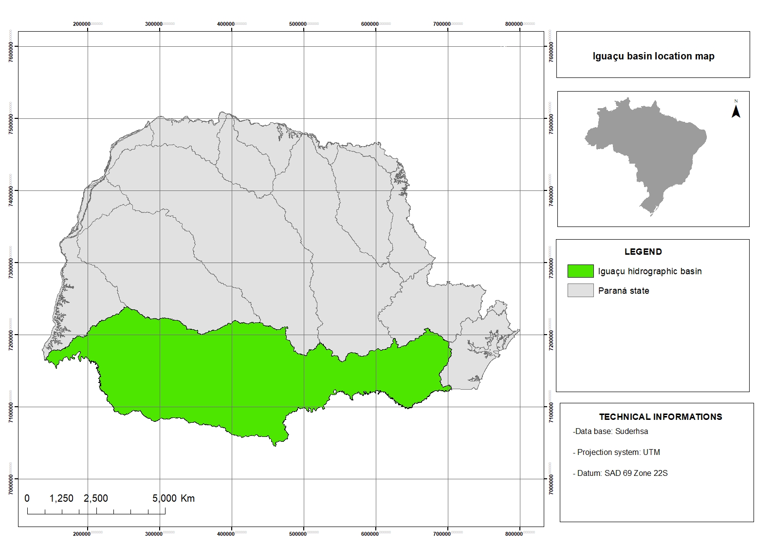
The Iguaçu River basin (Figure 1) covers an area of 69,373 km2 (Azevedo et al., 2003) and has the Iguaçu River as its main watercourse, formed by the confluence of the Atuba and Ivaí rivers, making it the largest river basin in the state of Paraná. Located between latitudes 25°05′00″ S and 26°45′00″ S and longitudes 48°57′00″ W and 54°50′00″ W, the basin lies in southern Brazil, encompassing the southern portion of the state of Paraná and the northern portion of the state of Santa Catarina (Merenda, 2004).

As a result of the atmospheric systems acting over the region, most of the basin is classified as Cfb climate according to the Köppen classification, corresponding to a temperate climate, with a mean temperature in the coldest month below 18 °C (mesothermal), a mean temperature in the warmest month below 22 °C, cool summers, and no defined dry season. The western portion of the basin is classified as Cfa climate (subtropical climate), characterized by a mean temperature in the coldest month below 18 °C and a mean temperature in the warmest month above 22 °C, hot summers, infrequent frost occurrence, and a tendency for rainfall concentration during the summer months, although without a defined dry season (IAPAR, 1994).
The basin drainage area encompasses 35 municipalities in the state of Paraná and includes five large hydropower plants: Governador Bento Munhoz da Rocha Netto (Foz do Areia), Governador Ney Braga (Segredo), Governador José Richa (Salto Caxias), Salto Osório, and Salto Santiago (Paraná, 2024). The region also hosts Iguaçu National Park, home to the Iguaçu Falls, a major hydrological attraction recognized as a UNESCO World Heritage Site and one of the Seven Natural Wonders of the World, which attracts tourists from across the globe.
The combined flooded area of these reservoirs covers approximately 515 km2 and stores about 18.5 × 10⁶ m3 of water. Together, these hydropower facilities account for approximately 41% of the total hydroelectric energy produced in the state of Paraná, support around 60% of the state’s grain production, and sustain about 23% of livestock production (Paraná, 2010).
2.2. Data collection and processing
Deforestation data were obtained from the Institute of People and Environment of the Amazon (Imazon, 2025) and from the Project for Monitoring Deforestation in the Legal Amazon by Satellite (PRODES) (INPE, 2005), which monitors clear-cut deforestation in the Legal Amazon using LANDSAT-class satellite imagery (20–30 m spatial resolution; 16-day revisit cycle). Methodological details of the PRODES database are described in Almeida et al. (2022). Monthly deforestation totals (km2) from January 2011 to December 2023 were analyzed, a period selected to ensure continuity and completeness of the data series.
Rainfall data for the Iguaçu River Basin (IRB), located in the state of Paraná, Brazil, were obtained from the databases of the National Institute of Meteorology (INMET, 2024), the Paraná State Energy Company (Copel, 2024), and the Institute of Water and Land (IAT, 2024). These data correspond to measurements from 64 rain gauges distributed within and along the boundaries of the basin, considering a maximum distance of 20 km from the basin perimeter. The temporal coverage of the rainfall dataset matches that of the Amazon deforestation data, spanning the period from 2011 to 2023. The geographic coordinates and identification information of all rain gauge stations used in this study are presented in Table 1.
To characterize the behavior of the variables, descriptive statistics and tests of parametric distribution were applied. Data normality was assessed using the Shapiro–Wilk test (shapiro.test function). As the variables did not follow a normal distribution, Spearman’s rank correlation coefficient—which does not require normality assumptions—was used to assess the relationship between deforestation and precipitation (Shapiro and Wilk, 1965; Yu and Hutson, 2024).
All analyses were conducted in the R programming language (R Core Team), using the stats package for statistical tests, dplyr for data manipulation, lubridate for date handling, readxl for data import, ggplot2 for data visualization, and Kendall for trend analysis using the Mann–Kendall test.
Additionally, the data were analyzed in relation to mean precipitation and deforestation under El Niño–Southern Oscillation (ENSO) conditions. Years were classified as El Niño, La Niña, or Neutral according to the classification proposed by GGWeather (2025) (Table 2), based on the ONI classification. This classification enabled the assessment of the influence of large-scale climate variability on the analyzed variables.
The deforestation rate results were compared with major political, institutional, and social events that may have influenced the observed fluctuations between 2011 and 2023. Information on these events was compiled from official legislation and reports, as well as from national and international news sources, including the Brazilian Forest Code (Law No. 12,651/2012) (Brasil, 2012), the Action Plan for the Prevention and Control of Deforestation in the Legal Amazon (PPCDAm) (Brasil, 2004), and journalistic coverage from outlets such as BBC News Brasil (2023) and G1 (2020). These data were synthesized and visualized in a timeline-based graphic developed in the BioRender (2024) application.
3. Results
3.1. Relationship between deforestation and rainfall
Spearman’s correlation analysis revealed a statistically significant negative relationship between Amazon deforestation (km2) and precipitation in the IRB from 2011 to 2023 (ρ = −0.285, p = 0.000314), as show in Figure 2. Although the correlation is weak in magnitude, the results indicate that increased deforestation in the Amazon is associated with reduced rainfall in the IRB.

Spearman correlation between the rate of deforestation in the Amazon and precipitation in the IRB between 2011 and 2023.
Additionally, the hypothesis of a temporal lag was tested by relating deforestation to precipitation in the subsequent year. In this case, the correlation was weak and not statistically significant (ρ = −0.089, p = 0.44), indicating no detectable lagged effect. This result suggests that, within the analyzed period, the influence of deforestation on rainfall in the IRB tends to occur within the same year, or that a one-year lag cannot be identified with the available data.
Despite the statistical significance observed in the contemporaneous analysis, the relatively low correlation coefficient indicates that rainfall variability in the IRB cannot be attributed solely to Amazon deforestation. Precipitation patterns are also influenced by seasonal variability, cold fronts, moisture transport systems, and large-scale climate oscillations, particularly the El Niño–Southern Oscillation (ENSO). These factors interact at different scales, collectively shaping the spatial and temporal distribution of rainfall in the basin.
3.2. Analysis of the relationship between deforestation in the Amazon and rainfall in the IRB in the context of ENSO
The results (Figure 3) indicate interannual variations in the rate of deforestation in the Amazon and in precipitation in the IRB throughout the analyzed period (2011–2023), highlighting the influence of extreme climatic events associated with ENSO.

The blue shading in Figure 3 represents years characterized by the positive phase of the El Niño phenomenon (moderate, strong and very strong), which typically results in reduced precipitation over the Amazon and increased rainfall in the IRB. The figure indicates that, during El Niño events, precipitation in the IRB increases (dashed blue line), in agreement with climatological literature. El Niño conditions are also commonly associated with drier conditions in the Amazon, favoring forest fires and, consequently, higher deforestation rates (red line). However, the data show that this relationship is not always linear, suggesting the influence of additional drivers of deforestation, as observed in 2019 and 2021.
Years highlighted in red correspond to the positive phase of La Niña (moderate, strong and very strong), such as 2011–2012 and 2020–2022. During these periods, a general tendency toward reduced precipitation in the IRB is observed (dashed blue line). Increased moisture over the Amazon during La Niña events typically suppresses forest fires and may promote vegetation regeneration, potentially contributing to reduced deforestation rates. Nevertheless, the graph reveals a marked increase in deforestation during 2020 and 2021 despite La Niña conditions, underscoring the strong influence of anthropogenic drivers, including economic pressures, public policies, land-use changes, and weakened environmental enforcement.
Analysis of mean deforestation rates (km2) in the Amazon and mean precipitation (mm) in the IRB reveals an overall increasing trend in deforestation, particularly after 2020, with the highest value recorded in July 2021 (2,095 km2). Rainfall in the IRB exhibits greater temporal variability; however, a tendency toward decreasing precipitation is observed during periods of increased deforestation. The lowest mean precipitation was recorded in July 2018 (10.14 mm).
Focusing on the austral summer months, when LLJs are more active and enhance moisture transport from the Amazon to southern Brazil, the lowest mean precipitation occurred in December 2021 (49.14 mm) in the IRB. Conversely, the highest mean precipitation was observed in October 2023, reaching 521.33 mm.
3.3. Political factors and their impact on Amazon deforestation
Political factors may have contributed to fluctuations in deforestation rates in the Amazon over time. These variations are likely associated with shifts in land-use and land-cover policies, changes in the implementation and enforcement of environmental regulations, and variations in the effectiveness of monitoring and inspection mechanisms, which at different periods have led to either increases or reductions in deforestation. Furthermore, the interaction between economic interests, governmental policy agendas, and international pressures has likely played a role in shaping deforestation dynamics, highlighting the complex relationship between political governance and ecosystem processes in Brazil.
Figure 4 illustrates selected political and institutional events that may have influenced deforestation patterns during the analyzed period, in addition to climatic drivers.

Timeline of events and deforestation rates in the Amazon. Source: Elaborated by the author at BioRender.com.
In May 2012, a revised version of the Brazilian Forest Code (Law No. 12,651/2012) was approved following strong pressure from the rural caucus in Congress. The revised legislation granted amnesty for illegal deforestation occurring prior to 2008 and relaxed restoration requirements for Permanent Preservation Areas and Legal Reserves. These changes increased perceptions of impunity and may have contributed to incentives for additional deforestation.
Another key institutional milestone was the Action Plan for the Prevention and Control of Deforestation in the Legal Amazon (PPCDAm), launched in 2004 and implemented in three phases until its conclusion in 2015. One of the main outcomes of this plan was substantial investment in strengthening the environmental enforcement capacity of the Brazilian Institute of Environment and Renewable Natural Resources (IBAMA). In contrast, between 2019 and 2020, several political measures were associated with increased deforestation and fire activity in the Amazon, including debates surrounding land regularization legislation, the suspension of the Amazon Fund, and significant budget cuts to environmental enforcement agencies.
The United Nations Climate Change Conference (COP 30), scheduled to take place in 2025 in Belém, Pará, Brazil, has intensified international pressure on the country to strengthen Amazon conservation efforts. This context, combined with a shift in federal environmental policy orientation from 2023 onward, has contributed to the reinstatement of environmental policies, enhanced enforcement actions, and a subsequent downward trend in deforestation rates observed in recent years.
4. Discussion
Marengo et al. (2009) emphasize that low-level jets (LLJs) in South America are meridional airflows occurring within the lowest kilometers of the atmosphere, reaching maximum intensity at approximately 2,000 m above the surface. Given the topography of South America, their primary role is the transport of moisture from tropical to subtropical regions. However, the detection and monitoring of South American LLJs remain challenging.
Montini et al. (2019) investigated the climatology, variability, trends, and detection methods of the South American LLJs, proposing improved seasonal criteria and examining their relationship with large-scale climate phenomena such as the ENSO. Their study employed modern reanalysis datasets and observational data to enhance LLJs identification and understanding. The authors highlight that LLJs detection is hindered by the use of fixed criteria, such as the Bonner criterion, which defines thresholds including wind speeds of at least 12 m s−1 at 850 hPa and vertical wind shear of at least 6 m s−1 between 850 and 700 hPa. This criterion was originally developed based on studies over the Great Plains of the United States, where wind regimes differ substantially from those in South America. Consequently, its application may lead to underestimation of genuine LLJs events during periods of weaker winds or overestimation under atypical conditions. Despite advances provided by modern reanalysis products—such as ERA-Interim, MERRA-2, and CFSR—which offer improved representation of LLJs structure due to higher spatial resolution and more efficient data assimilation systems, limitations persist in regions with sparse observational coverage, including the Andes and central Brazil.
Although a correlation exists between Amazon forest dynamics and the rainfall reaching the IRB via the LLJs, this is not the sole factor influencing regional precipitation. Nevertheless, it plays an important role in the overall hydroclimatic dynamics. The correlation identified in this study indicates that, despite its relatively weak magnitude, the relationship is statistically significant and consistent with climatological evidence reported in previous studies (Marengo et al., 2009; Vera et al., 2006; Arraut et al., 2012; Ferrante et al., 2023; Portella et al., 2022; Nicholls et al., 2025).
Variations in moisture transport by LLJs are significantly amplified by anthropogenic disturbances in the Amazon rainforest, particularly deforestation and biomass burning. Several studies have shown that both historical and ongoing deforestation negatively affect rainfall regimes in southeastern and southern Brazil (Silva et al., 2023; Smith et al., 2023; Ferrante et al., 2023). Future scenario projections further indicate that continued deforestation may intensify rainfall reductions in these regions, with implications for agriculture, water availability, and the frequency of extreme events (Satyamurty et al., 2013; Lejeune et al., 2015).
According to Montini et al. (2019), changes in the intensity and frequency of South American LLJs have intensified in recent decades. These changes have been attributed to the southwestward expansion of the South Atlantic Subtropical High (SASH), shifts in the subtropical jet stream, and modifications in the land–ocean thermal gradient associated with climate change. In addition, LLJs are strongly modulated by the El Niño–Southern Oscillation (ENSO), as Pacific sea surface temperature anomalies influence South American monsoon rainfall, thereby affecting the intensity of both the South Atlantic Convergence Zone (SACZ) and the LLJs. Chu (1991) analyzed ENSO-related climate anomalies in Brazil and reported that during El Niño years, precipitation in southern Brazil tends to be above average between April and December, as well as from March to July of the subsequent year, with pronounced peaks in May and June.
The LLJs also influence the transport of pollen, spores, agricultural pests, fungi, and seeds (Shapiro et al., 2016), and may even affect the development and spread of wildfires (Barad, 1961). In 2019, the Amazon region recorded 197,632 fire hotspots, a number that increased to 222,798 in 2020, representing a 120% increase relative to the average of previous years (INPE, 2025). Although El Niño events are commonly associated with increased fire activity in the Amazon due to intensified drought conditions in northern Brazil—as observed in 2015, when deforestation rates also increased—the data suggest that political and institutional factors may exert an even stronger influence.
In 2019, for instance, despite the presence of La Niña conditions, which typically enhance rainfall in the region, the Amazon experienced a marked increase in deforestation rates and fire occurrences. This pattern highlights the dominant role of anthropogenic and institutional drivers over climatic controls in certain periods.
This intensification may be partially associated with a political context less favorable to environmental protection. In 2019, Brazil experienced one of the most severe wildfire episodes recorded in the Amazon, with August 11 becoming known as the “Day of Fire.” During the same period, Bill No. 2633/2020 (Brazilian Congress)—commonly referred to as the “Land Grabbing Bill”—was under discussion. Derived from Provisional Measure No. 910/2019, the bill proposed mechanisms for the regularization of occupations on public lands, which may have contributed to increased perceptions of regulatory flexibility and, indirectly, to higher deforestation rates.
Another major setback in 2019 was the suspension of the Amazon Fund—the primary financial mechanism supporting deforestation prevention, monitoring, and control initiatives—by the federal government. This decision significantly reduced investments aimed at forest protection and environmental governance. In 2020, the situation worsened with the decision of the Federal Budget Secretariat to suspend funding for environmental enforcement agencies, including the Chico Mendes Institute for Biodiversity Conservation (ICMBio), the Brazilian Institute of Environment and Renewable Natural Resources (IBAMA), and the Ministry of the Environment and Climate Change (MMA). These budget cuts directly affected enforcement operations against illegal deforestation in the Legal Amazon and firefighting efforts in the Pantanal.
5. Conclusion
Deforestation in the Amazon was shown to be statistically associated with the precipitation reaching the IRB region, which is primarily transported by LLJs. This relationship is supported by both statistical analyses and meteorological studies, which indicate the fundamental role of the Amazon rainforest in the regional moisture cycle and in supplying atmospheric humidity to southern Paraná State. The advance of deforestation disrupts this balance and may intensify extreme events, such as prolonged droughts and changes in the spatial and temporal distribution of rainfall.
In addition, ENSO-related events exert a significant influence on deforestation and fire activity in the Amazon region, with downstream effects on LLJs and precipitation patterns in southern Brazil. However, the results indicate that political and institutional decisions have played an even more decisive role in this process. Weak environmental governance not only amplifies regional climate impacts but also undermines the ecosystem services provided by the world’s largest tropical rainforest.
Data Availability Statement
The deforestation data analyzed in this study were obtained from the PRODES monitoring program, provided by Imazon. Precipitation data were obtained from official meteorological records from the National Institute of Meteorology (INMET), the Companhia Paranaense de Energia (COPEL), and the Instituto Água e Terra (IAT). All datasets used in this study are derived from publicly available or institutional databases.
References
-
ALMEIDA, C.A., MAURANO, L.E.P., VALERIANO, D.M., CÂMARA, G., VINHAS, L., MOTTA, M. and AMARAL, S., 2022 [viewed 13 August 2025]. Metodologia utilizada nos sistemas Prodes e Deter [online]. 2. ed. São José dos Campos: INPE. Available from: http://mtc-m21d.sid.inpe.br/col/sid.inpe.br/mtc-m21d/2022/08.25.11.46/doc/publicacao.pdf
» http://mtc-m21d.sid.inpe.br/col/sid.inpe.br/mtc-m21d/2022/08.25.11.46/doc/publicacao.pdf -
ARRAUT, J.M., NOBRE, C., BARBOSA, H.M.J., OBREGON, G. and MARENGO, J., 2012. Rivers and Lakes: looking at large-scale moisture transport and its relation to Amazonia and to subtropical rainfall in South America. Journal of Climate, vol. 25, no. 2, pp. 543-556. https://doi.org/10.1175/2011JCLI4189.1
» https://doi.org/10.1175/2011JCLI4189.1 -
ARRAUT, J.R. and SATYAMURTY, P., 2009. Precipitation and water vapor transport in the Southern Hemisphere with emphasis on the South American region. Journal of Applied Meteorology and Climatology, vol. 48, no. 9, pp. 1902-1912. https://doi.org/10.1175/2009JAMC2030.1
» https://doi.org/10.1175/2009JAMC2030.1 - AZEVEDO, L.C., NERY, J.T. and ANDRADE, A.R., 2003. Análise da precipitação pluviométrica na bacia do Rio Iguaçu. Investigaciones Geográficas, no. 52, pp. 15-28.
-
BARAD, M.L., 1961. Low-altitude jet streams. Scientific American, vol. 205, no. 2, pp. 120-133. https://doi.org/10.1038/scientificamerican0861-120
» https://doi.org/10.1038/scientificamerican0861-120 -
BBC NEWS BRASIL, 2023 [viewed 13 August 2025]. Desmatamento na Amazônia: impactos de políticas ambientais e mudanças institucionais [online]. Available from: https://www.bbc.com/portuguese/articles/cz6xypqn53vo
» https://www.bbc.com/portuguese/articles/cz6xypqn53vo -
BIORENDER, 2024 [viewed 13 August 2025]. BioRender.com [Web-based application] [online]. Available from: https://biorender.com
» https://biorender.com -
BRASIL, 2012 [viewed 13 August 2025]. Lei nº 12.651, de 25 de maio de 2012. Dispõe sobre a proteção da vegetação nativa [online]. Diário Oficial da União, Brasília, DF, 28 maio. Available from: http://www.planalto.gov.br/ccivil_03/_ato2011-2014/2012/lei/l12651.htm
» http://www.planalto.gov.br/ccivil_03/_ato2011-2014/2012/lei/l12651.htm - BRASIL. Ministério do Meio Ambiente, 2004 [viewed 13 August 2025]. Plano de Ação para a Prevenção e Controle do Desmatamento na Amazônia Legal (PPCDAm) Brasília, DF: Ministério do Meio Ambiente.
- CHU, P.S., 1991. Brazil’s climate and ENSO. In: M. GLANTZ, R.W. KATZ and N. NICHOLLS, eds. Teleconnections linking worldwide climate anomalies Cambridge: Cambridge University Press, pp. 43-71.
-
COMPANHIA PARANAENSE DE ENERGIA – COPEL, 2024 [viewed 25 February 2024]. Monitoramento hidrológico [online]. Available from: https://www.copel.com/mhbweb/paginas/monitoramento.jsf
» https://www.copel.com/mhbweb/paginas/monitoramento.jsf -
FEARNSIDE, P.M., 2006. Desmatamento na Amazônia: dinâmica, impactos e controle. Acta Amazonica, vol. 36, no. 3, pp. 395-400. https://doi.org/10.1590/S0044-59672006000300018
» https://doi.org/10.1590/S0044-59672006000300018 -
FERRANTE, L., GETIRANA, A., BACCARO, F.B., SCHÖNGART, J., LEONEL, A.C.M., GAIGA, R., GAREY, M.V. and FEARNSIDE, P.M., 2023. Effects of Amazonian Flying Rivers on frog biodiversity and populations in the Atlantic Rainforest. Conservation Biology : The Journal of the Society for Conservation Biology, vol. 37, no. 3, pp. e14033. https://doi.org/10.1111/cobi.14033 PMid:36349503.
» https://doi.org/10.1111/cobi.14033 -
G1, 2020 [viewed 25 February 2024]. Fundo Amazônia tem R$ 2,9 bilhões em conta parados após paralisação pelo governo Bolsonaro, alerta rede de organizações [online]. Available from: https://g1.globo.com/natureza/noticia/2020/10/26/fundo-amazonia-tem-r-29-bilhoes-em-conta-parados-apos-paralisacao-pelo-governo-bolsonaro-alerta-rede-de-organizacoes.ghtml
» https://g1.globo.com/natureza/noticia/2020/10/26/fundo-amazonia-tem-r-29-bilhoes-em-conta-parados-apos-paralisacao-pelo-governo-bolsonaro-alerta-rede-de-organizacoes.ghtml -
GGWEATHER, 2025 [viewed 1 February 2025]. El Niño and La Niña years and intensities [online]. Available from: https://ggweather.com/enso/oni.htm
» https://ggweather.com/enso/oni.htm - INSTITUTO AGRONÔMICO DO ESTADO DO PARANÁ – IAPAR, 1994. Cartas climáticas do Estado do Paraná Londrina: IAPAR, 49 p. Documento, no. 18.
-
INSTITUTO ÁGUA E TERRA – IAT, 2024 [viewed 25 February 2024]. Sistema de Informações Hidrológicas [online]. Available from: http://www.sih-web.aguasparana.pr.gov.br/sih-web/gerarRelatorioAlturasDiariasPrecipitacao.do?action=carregarInterfaceInicial
» http://www.sih-web.aguasparana.pr.gov.br/sih-web/gerarRelatorioAlturasDiariasPrecipitacao.do?action=carregarInterfaceInicial -
INSTITUTO BRASILEIRO DE GEOGRAFIA E ESTATÍSTICA – IBGE, 2004 [viewed January 2025]. Mapa de Biomas e de Vegetação [online]. Available from: http://www.ibge.gov.br/home/presidencia/noticias/21052004biomashtml.shtm
» http://www.ibge.gov.br/home/presidencia/noticias/21052004biomashtml.shtm -
INSTITUTO DO HOMEM E MEIO AMBIENTE DA AMAZÔNIA – IMAZON, 2025 [viewed 13 August 2025]. Plataforma SAD – Sistema de Alerta de Desmatamento [online]. Belém: Imazon. Available from: https://imazon.org.br/sad/
» https://imazon.org.br/sad/ -
INSTITUTO NACIONAL DE METEOROLOGIA – INMET, 2024 [viewed 20 May 2024]. Banco de Dados Meteorológicos: Dados históricos anuais [online]. Available from: https://portal.inmet.gov.br/dadoshistoricos
» https://portal.inmet.gov.br/dadoshistoricos - INSTITUTO NACIONAL DE PESQUISAS ESPACIAIS – INPE, 2005. Prodes - Programa de desmatamento da Amazônia – Monitoramento da floresta amazônica por satélite São José dos Campos: INPE/IBAMA.
- INSTITUTO NACIONAL DE PESQUISAS ESPACIAIS – INPE, 2025. Centro de Previsão de Tempo e Estudos Climáticos (CPTEC) São José dos Campos: INPE.
-
LEJEUNE, Q., DAVIN, E.L., GUILLOD, B.P. and SENEVIRATNE, S., 2015. Influence of Amazonian deforestation on the future evolution of regional surface fluxes, circulation, surface temperature and precipitation. Climate Dynamics, vol. 44, no. 9-10, pp. 2769-2786. https://doi.org/10.1007/s00382-014-2203-8
» https://doi.org/10.1007/s00382-014-2203-8 - MARENGO, J.A., AMBRIZZI, T. and SOARES, W.R., 2009. Jatos de Baixos níveis ao longo dos Andes. In: I.F.A. CAVALCANTI, ed. Tempo e clima no Brasil São Paulo: Oficina de Textos, pp. 169-180.
- MERENDA, E.A., 2004. Reservatório de Segredo e área de entorno: aspectos legais e modificações no uso do solo Maringá: Universidade Estadual de Maringá. MSc Dissertation in Geography.
-
MONTINI, T.L., JONES, C. and CARVALHO, L.M.V., 2019. The South American low‐level jet: A new climatology, variability, and changes. Journal of Geophysical Research. Atmospheres, vol. 124, no. 3, pp. 1200-1218. https://doi.org/10.1029/2018JD029634
» https://doi.org/10.1029/2018JD029634 -
MYERS, N., MITTERMEIER, R.A., MITTERMEIER, C.G., FONSECA, G.A.B. and KENT, J., 2000. Biodiversity hotspots for conservation priorities. Nature, vol. 403, no. 6772, pp. 853-858. https://doi.org/10.1038/35002501 PMid:10706275.
» https://doi.org/10.1038/35002501 -
NICHOLLS, J.A., RINGELBERG, J.J., DEXTER, K.G., LOISEAU, O., STONE, G.N., COLEY, P.D., HUGHES, C.E., KURSAR, T.A., KOENEN, E.J.M., GARCIA, F., LEMES, M.R., NEVES, D.R.M., ENDARA, M.J., DE LIMA, H.C., KIDNER, C.A. and PENNINGTON, R.T., 2025. Continuous colonization of the Atlantic coastal rain forests of South America from Amazônia. Proceedings. Biological Sciences, vol. 292, no. 2039, pp. 20241559. https://doi.org/10.1098/rspb.2024.1559 PMid:39837505.
» https://doi.org/10.1098/rspb.2024.1559 - PADUA, J.A., 2015. A Mata Atlântica e a Floresta Amazônica na construção do território brasileiro: estabelecendo um marco de análise. Revue de l’Histoire des Religions, vol. 20, no. 2, pp. 232-251.
-
PARANÁ, 2024 [viewed 1 February 2025]. Inaugurada Usina Baixo Iguaçu no sudoeste do Estado [online]. Agência Estadual de Notícias. Available from: https://www.aen.pr.gov.br/Noticia/Inaugurada-Usina-Baixo-Iguacu-no-Sudoeste-do-Estado
» https://www.aen.pr.gov.br/Noticia/Inaugurada-Usina-Baixo-Iguacu-no-Sudoeste-do-Estado - PARANÁ. Instituto das Águas do Paraná, Secretaria do Estado do Meio Ambiente e Recursos Hídricos, 2010. Elaboração do Plano Estadual de Recursos Hídricos: Anexo I da revisão final do “Produto 1.1. Diagnóstico das demandas e disponibilidades hídricas superficiais (definição do balanço entre disponibilidade e demandas)” [online]. Curitiba: IAT.
-
PORTELLA, D.A.P.C., BLANCO, L.S., MELLO FILHO, M.E.T. and SANTOS, J.L.A., 2022. A importância da Amazônia na dinâmica climática do centro-sul brasileiro: influência nas dinâmicas ambientais e socioeconômicas. Ensaios de Geografia, vol. 9, no. 19, pp. 66-86. https://doi.org/10.22409/eg.v9i19.54944
» https://doi.org/10.22409/eg.v9i19.54944 -
RIBEIRO, M.C., METZGER, J.P., MARTENSEN, A.C., PONZONI, F.J. and HIROTA, M.M., 2009. The Brazilian Atlantic Forest: how much is left, and how is the remaining forest distributed? Implications for conservation. Biological Conservation, vol. 142, no. 6, pp. 1141-1153. https://doi.org/10.1016/j.biocon.2009.02.021
» https://doi.org/10.1016/j.biocon.2009.02.021 - SALATI, E., 2001. Mudanças climáticas e o ciclo hidrológico na Amazônia. In: V. FLEISCHRESSER, ed. Causas e Dinâmica do Desmatamento na Amazônia Brasília, DF: Ministério do Meio Ambiente, pp. 153-172.
-
SATYAMURTY, P., COSTA, C.P.W. and MANZI, A.O., 2013. Moisture source for the Amazon Basin: a study of contrasting years. Theoretical and Applied Climatology, vol. 111, no. 1-2, pp. 195-209. https://doi.org/10.1007/s00704-012-0637-7
» https://doi.org/10.1007/s00704-012-0637-7 -
SHAPIRO, A., FEDOROVICH, E. and RAHIMI, S., 2016. A unified theory for the great plains nocturnal low-levels jet. Journal of the Atmospheric Sciences, vol. 73, no. 8, pp. 3037-3057. https://doi.org/10.1175/JAS-D-15-0307.1
» https://doi.org/10.1175/JAS-D-15-0307.1 -
SHAPIRO, S.S. and WILK, M.B., 1965. An analysis of variance test for normality (complete samples). Biometrika, vol. 52, no. 3/4, pp. 591-611. https://doi.org/10.2307/2333709
» https://doi.org/10.2307/2333709 -
SILVA, M.E.S., ROCHA, R.P., PEREIRA, G., ROCHA, A.M., MENDES, D. and SILVA, C.B., 2023. The combined influences of Amazon deforestation and pacific decadal oscillation on the South America climate variability. International Journal of Climatology, vol. 43, no. 5, pp. 2127-2149. https://doi.org/10.1002/joc.7967
» https://doi.org/10.1002/joc.7967 -
SMITH, C., BAKER, J.C.A. and SPRACKLEN, D.V., 2023. Tropical deforestation causes large reductions in observed precipitation. Nature, vol. 615, no. 7951, pp. 270-275. https://doi.org/10.1038/s41586-022-05690-1 PMid:36859548.
» https://doi.org/10.1038/s41586-022-05690-1 -
SOBRAL-SOUZA, T., LIMA-RIBEIRO, M.S. and SOLFERINI, V.N., 2015. Biogeography of Neotropical Rainforests: Past Connections between Amazon and Atlantic Forest Detected by Ecological Niche Modeling. Evolutionary Ecology, vol. 29, no. 5, pp. 643-655. https://doi.org/10.1007/s10682-015-9780-9
» https://doi.org/10.1007/s10682-015-9780-9 -
VERA, C., BAEZ, J., DOUGLAS, M., EMMANUEL, C.B., ORSINI, J.A.M., MEITIN, J., NICOLINI, M., NOGUES-PAEGLES, J., PAEGLE, J., PENALBA, O., SALIO, P., SAULO, C., SILVA DIAS, M.A.F., SILVA DIAS, P. and ZIPSER, E., 2006. The South American low level jet experiment. Bulletin of the American Meteorological Society, vol. 87, no. 1, pp. 63-77. https://doi.org/10.1175/BAMS-87-1-63
» https://doi.org/10.1175/BAMS-87-1-63 -
YU, H. and HUTSON, A.D., 2024. A robust Spearman correlation coefficient permutation test. Communications in Statistics. Theory and Methods, vol. 53, no. 6, pp. 2141-2153. https://doi.org/10.1080/03610926.2022.2121144 PMid:38646087.
» https://doi.org/10.1080/03610926.2022.2121144
Edited by
-
Editor:
Takako Matsumura Tundisi