 User-centred geospatial system design through design thinking: functional and semantic insights from Brazil and South Africa
Abstract:
This paper presents the application of Design Thinking to the participatory development of geoinformation systems in Brazil and South Africa. The study explores how empathy-based, iterative design methods can elicit not only functional requirements but also reveal semantic and terminological variations among stakeholders with diverse backgrounds. Through structured workshops, participants collaboratively defined user needs, mapped spatial concepts, and co-designed system features for two distinct scenarios: a national land management platform in Brazil and a geospatial dashboard for Sustainable Development Goals (SDGs) in South Africa. As part of the process, a reusable script for participatory sessions and a comparative vocabulary of 91 geospatial terms were developed. Results show how shared core concepts coexist with region-specific terminologies, underscoring the need for standardisation to enhance interoperability. The study demonstrates that Design Thinking can facilitate semantic alignment and functional adequacy in multilingual and multi-institutional environments, offering replicable tools for inclusive, user-centred geospatial system design.
Keywords:
Design Thinking; Semantic Interoperability; Cross-Cultural Interfaces; Geoinformation Systems; User-Centered Design
1. Introduction
The development of geospatial systems has traditionally followed structured, technically oriented approaches grounded in established cartographic principles. However, the growing diversity of map users and the widespread use of digital spatial interfaces, such as dashboards, mobile devices, and web-based mapping platforms, highlight the need for user-centred and participatory methodologies. These approaches must account for how individuals conceptualise, describe, and interact with spatial information across cultural, linguistic, and professional contexts.
This evolution reflects long-standing debates in Cartography. Since the 1970s, research has investigated how users engage with maps, beginning with map communication models (Board, 1981; Olson, 1976) and later advancing toward cognitive alignment, visual tasks, and interaction paradigms (MacEachren, 1994; van Elzakker, 2004). Today, the ubiquity of spatial data and interfaces (Griffin & Fabrikant, 2012) has created an environment in which expert and non-expert users generate and consume maps daily, often without formal cartographic training. As Griffin and Fabrikant (2012) emphasise, addressing the design of geospatial representations now requires integrating multiple knowledge domains-cognition, behaviour, and technological representation-a challenge that traditional workflows alone cannot address.
Research increasingly confirms a persistent gap in understanding how to incorporate users’ rich, contextual, and often tacit knowledge-shaped by cultural, professional, and linguistic backgrounds-into coherent and interoperable semantic systems (Griffin et al., 2017; Robinson et al., 2017; Kang et al., 2024). Such knowledge is frequently subjective and participatory in nature (Gartner, 2025; Nelson et al., 2025), yet most geoinformation infrastructures still rely on provider-driven, top-down conceptualisations that insufficiently reflect how users organically describe and interpret spatial phenomena in real-world applications (Kotsev et al., 2020). Recent policy frameworks reinforce this limitation, emphasising that spatial data infrastructures must evolve toward more inclusive, user-centred, and socially responsive models that recognise diverse forms of geospatial knowledge (UN-GGIM, 2023). Bridging this gap is essential to ensuring that geoinformation systems remain effective, interoperable, and relevant across varied cultural, linguistic, and professional contexts.
Foundational works in cartography have already highlighted these tensions. Griffin and Fabrikant (2012) noted that the increasing diversity of maps, users, and devices demands an integrated understanding of how people think, reason, and work with geospatial information. More recent research reinforces the importance of examining not only how users interact with geospatial systems but also how developers, analysts, and domain specialists conceptualise spatial information differently (Coetzee et al., 2021; Griffin et al., 2021). These divergences generate vocabulary deficits, misinterpretations, and fragmented semantic alignment-particularly in interdisciplinary or multilingual teams where developers may lack cartographic training. Consequently, systems may technically comply with standards yet remain conceptually misaligned with users’ interpretative models. Without addressing these issues, such systems risk reduced usability, decreased communicative power, and limited relevance for decision-making and social transformation.
Addressing design challenges in geospatial systems requires not only capturing functional requirements but also understanding how spatial concepts and cartographic terms emerge in bottom-up, participatory contexts. The literature recognises the importance of geospatial semantics for interoperability (Fonseca et al., 2002; Kuhn, 2005; Sun et al., 2019), but empirical studies analysing how users articulate spatial ideas remain scarce, especially in cross-cultural settings. This limitation is particularly relevant for modern system development, where interdisciplinary teams depend on shared conceptual models to co-create effective geoinformation solutions.
Thus, semantic variability is not a peripheral issue; it is central to user-centred geospatial design. Understanding differences and convergences in terminology can reveal cognitive models, knowledge gaps, and opportunities for alignment-ultimately supporting systems that are more coherent, interoperable, and inclusive.
Although advances in cartography, geovisualisation, and semantic interoperability have improved theoretical foundations, important gaps remain in the empirical analysis of how users conceptualise spatial phenomena during early design stages. The existing literature has documented conceptual mismatches between expert-driven system design and end users’ cognitive models, yet few studies have investigated these mismatches in participatory and cross-cultural settings. Additionally, the interaction between functional requirements and semantic interpretations is often overlooked, even though both dimensions decisively influence usability and interoperability. Comparative analyses that examine how cartographic terminology varies across linguistic, institutional, and disciplinary boundaries are also limited. Finally, despite recurring calls for user-centred and inclusive approaches in Cartography and GIScience, drawing on user-centred design and usability principles (Nielsen 1993; MacEachren 1995; Slocum et al. 2001; Sieber 2006; Roth 2013; Haklay 2013), there remains a lack of practical frameworks that guide interdisciplinary teams in translating bottom-up user knowledge into coherent cartographic and system design decisions. These gaps collectively underscore the need for systematic investigations that integrate participatory design, semantic analysis, and geospatial system development.
In response to these gaps, this study investigates how participatory, empathy-based design methods, specifically Design Thinking, can support the elicitation of both functional requirements and semantic patterns in the early stages of geoinformation system development. By analysing two contrasting contexts, Brazil and South Africa, the research explores how stakeholders with different professional backgrounds and cultural experiences conceptualise spatial information and express cartographic terminology during collaborative design activities. The study is guided by the hypothesis that participatory workshops can reveal semantic convergences and divergences that are not captured through traditional requirements engineering approaches, and that these insights can enhance the inclusiveness, interpretability, and interoperability of geospatial systems.
The study makes three main contributions. First, it provides a comparative empirical analysis of how users articulate spatial concepts in two distinct sociotechnical settings, highlighting differences and shared understandings that influence system design. Second, it identifies functional and semantic patterns emerging from the workshops, demonstrating how these dimensions interact and how they can be systematically incorporated into early design processes. Third, it proposes a transferable structure for participatory geospatial design sessions, offering practical guidance for integrating semantic reflection into system conception. Together, these contributions advance ongoing discussions in Cartography and GIScience about the need for more user-centred, semantically aware, and context-responsive approaches to geoinformation system development.
2. Methodology
This study adopted a qualitative, participatory research design grounded in Design Thinking (DT) and informed by principles of Requirements Engineering. DT is a user-centred approach to solving complex problems, initially systematised by Rowe (1987) as an intuitive and exploratory practice. It was later structured into stages, including empathy, definition, ideation, prototyping, and testing (Doorley et al., 2018). Brown (2008) expanded this understanding by emphasising DT’s role in balancing technological feasibility, user desirability, and business viability. In this study, DT was selected as the methodological framework because it supports empathy-based, collaborative, and iterative processes that are essential for early-stage system design (Brown, 2008), specifically focusing on the Define stage to elicit user needs and conceptual models.
The methodological approach was structured around a series of four workshops conducted in two national contexts-Brazil and South Africa-involving a total of 24 participants. All procedures were approved by the Research Ethics Committee of the Federal University of Paraná (CAAE: 73395423.9.0000.0102; Decision No. 6.564.353). The following subsections detail the study settings, data collection instruments, and analytical procedures.
2.1 Study Sites and Participants
The selection of study sites was driven by the opportunity to contrast a real-world, institutional development scenario with an exploratory, academic one.
Brazil was selected because the research team had access to the TED-INCRA/UFPR programme, an ongoing federal cooperation for land management and geospatial monitoring. Further details on the project’s scope and execution are available in its official documentation (Araujo et al., 2025) and institutional portal (https://lageamb.ufpr.br/ted-incra/). This context allowed for direct interaction with practitioners actively involved in system development. Three independent workshops were conducted at the LAGEAMB laboratory (UFPR, Curitiba), each with six participants (total n=18). The decision to hold three sessions in Brazil was based on the need to capture the diversity of perspectives within the large multidisciplinary team (c. 140 staff) and to reach saturation in requirements elicitation within this complex institutional setting.
South Africa was included to provide a comparative, cross-cultural perspective. This selection was facilitated by the lead author’s visiting research fellowship (“sandwich doctorate”) at the University of Pretoria, funded by the CAPES/PRINT UFPR project “Espaço, Sociedade e Desenvolvimento” (Space, Society and Development). This academic mobility enabled direct collaboration with local researchers. Due to the exploratory nature of this partnership and logistical constraints, a single workshop was conducted with a cohort of six doctoral-level geographers (n=6).
To ensure methodological consistency and comparability despite the difference in the number of sessions, the single South African workshop was designed to be equivalent in size (n=6) and structure to each individual Brazilian workshop. The analysis (detailed in Section 2.3) treated the Brazilian workshops first as individual units to identify recurring patterns, which were then synthesised before being compared with the South African results. Table 1 summarises the characteristics of both settings.
2.2 Data Collection Instruments and Procedure
All workshops followed an identical Design Thinking protocol and a structured script of questions (available at https://anonymous.4open.science/r/Workshop_doc-61C2/). The script was developed based on the 10QViz framework (Çöltekin & Goodman, 2022) for interactive visualisation design and the Cartographic Project methodology (Sluter, 2008). It guided discussions on target users, system objectives, spatial data content, reference systems, interaction tools, and metadata practices. Table 2 presents a sample of these guiding questions, illustrating thematic consistency across the two national contexts.
Each workshop lasted approximately three hours. The sessions were moderated by a cartographer who acted as a facilitator, encouraging empathy and collaboration by asking participants to describe their daily workflows and challenges before moving to technical specifications. Data collection relied on three complementary sources:
-
Audio Recordings: All sessions were recorded to capture the natural discourse and terminology.
-
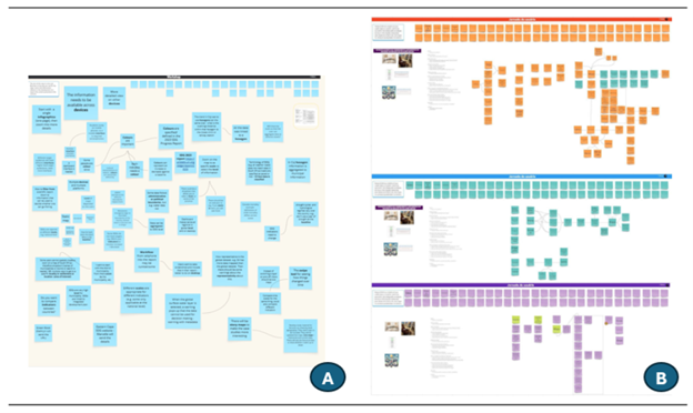
Collaborative Digital Boards (MIRO): Participants and facilitators used the MIRO platform to collectively record key terms, sketch system requirements, and map relationships in real time (see Figures 1 and 2).
-
Field Notes: Facilitators documented group dynamics and non-verbal consensus.
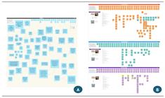
Collaborative digital boards (Miro) used during the workshops. (A) South Africa session, focusing on exploratory concept mapping for SDG indicators. (B) Brazil sessions, focusing on functional requirements for the TED-INCRA dashboard. Note: Figure B represents the original record in Portuguese; key terms were subsequently translated for analysis.
2.3 Data Analysis
The analysis followed a systematic procedure to process both functional requirements and semantic data:
Transcription and Translation: The recorded audio was transcribed in full. Portuguese terms and requirements from the Brazilian workshops were translated into English to enable systematic comparison with the South African data. It should be noted that Portuguese terms elicited during the Brazilian workshops were translated into English for comparative analysis. This methodological decision entails potential limitations, as translation may introduce semantic shifts, obscure culturally embedded meanings, or smooth nuances present in the original language. To mitigate these effects, translations prioritized conceptual equivalence over literal correspondence, and original Portuguese terms were retained and revisited during analysis whenever interpretative ambiguity arose. The translation process was carried out by researchers fluent in both Portuguese and English and familiar with cartographic terminology, supporting consistency and semantic validity across cases.
Term Extraction: Cartographic and system-related terms were extracted from both the transcripts and the MIRO boards. These terms were normalised (to remove duplicates and morphological variations) and compiled into a single dataset. This process resulted in a corpus of 91 unique terms.
Requirements Synthesis: Functional and non-functional requirements were analysed using thematic synthesis. In Brazil, the results from the three workshops were first cross-referenced to identify convergent requirements (those appearing in multiple sessions) and specific nuances. This synthesised set was then compared with the requirements elicited in the South African workshop.
This analytical design sought to minimise the impact of inconsistencies in data collection on the observed differences, thereby prioritising the influence of conceptual, cultural, and professional factors.
3. Results
This section details the outcomes of the participatory workshops, organised into two main dimensions: functional requirements (Section 3.1) and semantic patterns (Section 3.2). These findings are based on analyses of participant interactions, MIRO board inputs, and transcribed discussions.
3.1 Elicited Requirements and System Definitions
The workshops yielded distinct requirement sets that reflect the contrasting nature of the two case studies: the exploratory, policy-oriented scenario in South Africa and the operational, execution-oriented scenario in Brazil.
The South African workshop was exploratory, focusing on the design of a geospatial system for visualising Sustainable Development Goal (SDG) indicators. Based on global open data and hypothetical usage scenarios, the requirements reflected priorities related to policy support, academic use, and public engagement. Table 3 details these requirements. Notably, participants emphasised Non-Functional requirements related to accessibility (e.g., colour-blind friendly palettes) and Functional requirements for advanced data interaction, such as hexagonal binning and swipe tools for temporal comparison. This reflects a user profile focused on data communication and policy advocacy rather than on daily operational management.
In contrast, Brazilian workshops were embedded in a real-world context-the TED-INCRA/UFPR project. The requirements, detailed in Table 4, are significantly more granular with respect to data production and administrative control. Participants collaboratively defined a comprehensive set of functional and non-functional requirements for a geospatial system to support land management and settlement monitoring. These requirements reflect the needs of multiple stakeholders involved in the project, including developers, cartographers, public administrators, and field teams. Table 4 summarises the elicited requirements and includes descriptions of the system’s purpose, tools, indicators, symbology, technologies, and reference standards.
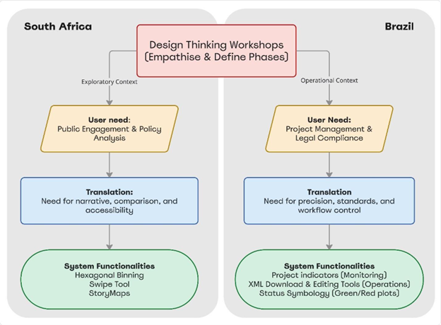
To illustrate the relationship between these requirements and the system logic, Figure 2 presents a synthesis diagram that maps the flow from user needs to system functionalities, as identified in both contexts.
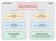
Synthesis of the requirement elicitation process. The diagram illustrates how the Design Thinking methodology (central node) diverged into distinct functional specifications based on the specific user needs of the exploratory context (South Africa) versus the operational context (Brazil).
3.2 Cartographic Terminology and Semantic Observations
Beyond functional design considerations, the workshops provided valuable insights into how participants articulated, interpreted, and negotiated cartographic concepts. Across both languages and study contexts, a total of 91 unique terms were identified, including lexical variations. These observations reveal patterns of semantic convergence and divergence that are particularly relevant to collaborative geoinformation system design.
A shared core vocabulary emerged in both countries, including terms such as map, layer, metadata, dashboard, and interactive map. This common ground suggests a broadly aligned geospatial language that transcends regional and institutional contexts, forming a basis for mutual understanding in collaborative design processes. At the same time, region-specific influences were evident. Brazilian participants frequently employed terminology associated with land regularisation and territorial governance, such as assentamento, lote, and regularização fundiária, reflecting the institutional and socio-political context in which the system is embedded. In contrast, South African participants more often referred to concepts such as SDG, hexagon mapping, and indicator warnings, aligning with monitoring, reporting, and sustainability-oriented perspectives.
Differences were also observed according to professional background. Participants with formal training in cartography tended to use standardised terminology aligned with national and international institutions and norms (e.g. IBGE, INCRA, ISO). In contrast, developers and data analysts more frequently adopted language rooted in software engineering, interface design, and spatial modelling. Discussions of symbols and colour schemes further highlighted these distinctions: Brazilian groups often referenced official cartographic design standards, whereas South African participants emphasised accessibility considerations and interpretive meanings, particularly for diverse user groups.
Variations in the understanding of scale and level of detail also emerged. Brazilian participants placed greater emphasis on fine-scale data to support local land management and decision-making, whereas South African participants prioritised aggregated representations suitable for regional or national overviews. Despite these differences, both groups converged on the importance of interactivity, recommending features such as swipe tools, dropdown filters, and search functions. These suggestions explicitly linked cartographic expression to usability and user experience in digital interfaces.
Importantly, the diversity of professional backgrounds influenced how participants formulated their contributions. In Brazil, the multidisciplinary nature of the group comprising software developers, geodesists, cartographers, and project managers led to a wide range of system-related terminology. In South Africa, the participants’ academic orientation in geography and cartography brought a focus on representational clarity and data structuring. The number of sessions also contributed to the breadth of data: three workshops in Brazil versus one in South Africa.
Finally, instances of semantic misalignment were identified, in which identical terms conveyed different meanings across institutional, professional, or cultural contexts. These cases were recorded as part of the empirical results and are further examined in the discussion section.
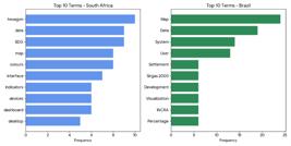
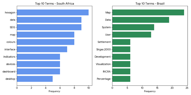
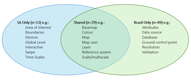
Figure 3 presents the frequency of the most recurrent terms identified in the MIRO dashboards for each country, providing a quantitative overview of the qualitative data. Figure 4 illustrates representative examples of shared and specific terminology identified across both workshops. The complete list of terms is provided in the supplementary material.
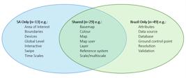
Venn diagram illustrating examples of cartographic terms identified in the Brazilian and South African workshops. The complete list of terms is provided in the supplementary material (https://anonymous.4open.science/r/Workshop_doc-61C2/)
The complete list of terms, including language variations, is provided in the supplementary material. For standardisation purposes, the proposed vocabulary prioritises universal concepts that appear across both contexts (e.g., layer, dashboard, scale), which form the semantic backbone of interoperable design. Context-specific acronyms and institutional references were documented to support the analysis of local operational cultures. However, they were excluded from the universal lexicon because they represent scenario-specificity rather than elements of a shared geoinformation language.
4. Discussion
4.1 Design Thinking as a Driver for Requirements Elicitation
During the analysis of the results, it was possible to identify requirements to define a coherent initial set of needs and functionalities for developing the proposed systems in each workshop. This demonstrated the applicability of the Design Thinking methodology in gathering requirements for geoinformation systems.
The initial Design Thinking sessions were exploratory and collaborative in nature in both countries. Their main aim was to gather user needs, identify stakeholders, map key challenges, and align expectations. During this phase, participants shared experiences, identified problems, and began sketching out possible solutions. The cartographer acted as a facilitator, guiding discussions and documenting the essential requirements for developing the geospatial system.
The workshops produced two distinct sets of requirements for each project: one focused on system development information, such as programming languages, user profiles, and system objectives; and a second set related to specific map requirements, including symbology, reference systems, map information, navigation tools and data, among other elements.
A methodological limitation of the study is the asymmetry in data sources: three workshops were conducted in Brazil and one in South Africa, resulting in a larger dataset from Brazil. To address this imbalance, the three Brazilian sessions were first synthesised into a single “institutional voice” prior to cross-context comparison. This procedure revealed that the additional Brazilian workshops primarily increased the granularity of operational terminology (e.g. references to specific legal instruments or document types), rather than introducing new conceptual categories. As a result, despite differences in term frequency, the underlying semantic categories remained comparable, supporting the validity of the cross-context analysis.
4.2 Semantic Dimensions of Cartographic Language
The results reveal a dynamic interaction between bottom-up language emerging from participatory workshops and top-down standardisation frameworks commonly adopted in geoinformation systems. Despite linguistic, institutional, and contextual differences, many of the terms used in both countries were semantically aligned, suggesting the influence of globally disseminated practices and standards, particularly those promoted by ISO/TC 211 and the OGC.
The shared terminology identified in the intersection of Figure 4 represents a fundamental cognitive core among GIS users. Terms related to interface structure and interaction-such as dashboard, filter, and interactive map-appeared consistently across contexts, indicating converging expectations regarding usability and system behaviour. This convergence points to the emergence of a transversal vocabulary shaped by global digital mapping environments rather than by local institutional frameworks alone.
At the same time, the results highlight how professional background and institutional setting shape semantic expression. In Brazil, the multidisciplinary composition of the group fostered terminology closely aligned with national cartographic standards and operational practices, often influenced by agencies such as IBGE and institutional conventions at UFPR. In South Africa, participants’ academic profiles were associated with greater alignment with international geoinformation agendas, particularly those related to SDG monitoring and spatial indicators.
These differences have direct implications for interoperability. While terms such as metadata appeared in both contexts, their underlying meanings differed: some participants associated metadata with strict data provenance and validation requirements, whereas others used it more broadly as system-level documentation. This illustrates that semantic harmonisation requires attention not only to shared labels but also to the contextual meanings attached to them.
The distinction between raw terminology elicited during participatory processes and the consolidated vocabulary proposed for system design is therefore crucial. While the full range of terms reflects the diversity of perspectives and practices, the vocabulary intended for standardisation must prioritise shared concepts that support interoperability. Context-specific acronyms and institutional references can be understood as local semantic “dialects” that remain important for operational analysis but are less suitable as components of a universal design language.
Overall, these findings support the feasibility of constructing an open, controlled vocabulary that bridges bottom-up user language and top-down standards. Such a vocabulary can function as a semantic bridge between heterogeneous professional communities, contributing to the development of more interoperable and user-centred geoinformation systems. This approach complements ongoing international efforts coordinated by the OGC, ISO/TC 211, and the International Cartographic Association (ICA), while grounding semantic alignment in empirical, participatory evidence (Coetzee et al., 2021).
5. Conclusion
This study presented the results of an applied, comparative investigation conducted in Brazil and South Africa to examine how Design Thinking can support the early-stage development of geoinformation systems. Through participatory workshops, stakeholders with diverse professional backgrounds collaboratively defined functional requirements and articulated cartographic terminology, thereby enabling the empirical identification of both operational needs and semantic patterns.
The findings demonstrate that Design Thinking is effective in eliciting not only functional and non-functional system requirements, but also semantic insights that are typically overlooked in traditional requirements engineering approaches. While the Brazilian case revealed highly granular, operation-oriented requirements embedded in an institutional context, the South African case highlighted exploratory and communication-focused needs. Despite these differences, a shared core vocabulary emerged across both contexts, indicating common conceptual ground for the design of interoperable systems.
From a semantic perspective, the identification of 91 cartographic terms, comprising both shared and context-specific expressions, highlights the importance of controlled vocabularies capable of supporting multilingual and multi-institutional environments. The results show that semantic alignment requires attention not only to standardised terminology, but also to how terms are interpreted and used by different professional communities.
As practical contributions, this study provides a transferable workshop script for participatory geospatial system design and a preliminary comparative vocabulary to inform future standardisation and interface development. These outputs demonstrate the applicability of the approach across distinct institutional settings and its potential to improve usability, coherence, and interoperability in geoinformation systems.
Future research may expand the proposed vocabulary and test the methodology in additional cultural, organisational, and application contexts, further strengthening its generalisability and contribution to user-centred cartographic design.
REFERENCES
-
Araujo, V. S., Constancio, A. S., Villela Junior, D. D. S., De Souza, E. F., Da Silva, E. D. B., Bencz, L. D. F., Da Costa, L. H., Pereira, V. A., & Camboim, S. P. (2025). Parceria Universidade Federal do Paraná-INCRA para regularização fundiária: gestão de dados geoespaciais no contexto de Termos de Execução Descentralizada. I Congresso Internacional de Regularização Fundiária & VIII Simpósio Brasileiro de Ciências Geodésicas e Tecnologias da Geoinformação (I CIRF & VIII SIMGEO), Recife, PE, Brazil. https://doi.org/10.5281/zenodo.17132815
» https://doi.org/https://doi.org/10.5281/zenodo.17132815 -
Board, C. (1981). Cartographic communication. Cartographica, 18(2), 42-78. https://doi.org/10.3138/8R07-2125-L843-0767
» https://doi.org/https://doi.org/10.3138/8R07-2125-L843-0767 - Brown, T. (2008). Design thinking. Harvard business review, 86(6), 84.
-
Coetzee, S., Griffin, A.L., Köbben, B., Kubicek, P., Harvey, F., Varanka, D.E., Camboim, S.P., Behr, F.-J., Plews, R., Moellering, H. and Midtbø, T., 2021. Mapping in words: standardising cartographic terminology. Abstracts of the ICA, 3, pp.1-3. Available at: https://doi.org/10.5194/ica-abs-3-54-2021
» https://doi.org/https://doi.org/10.5194/ica-abs-3-54-2021 -
Çöltekin, A., & Goodman, A. (2022). Guiding visualization practice with questions: 10qviz.org. http://coltekin.net/arzu/publications/coltekin_goodman_shortpaper_IEEE_visguides.pdf
» http://coltekin.net/arzu/publications/coltekin_goodman_shortpaper_IEEE_visguides.pdf -
Doorley, S., Holcomb, S., Klebahn, P., Segovia, K., & Utley, J. (2018). Design Thinking Bootleg. d.school at Stanford University. https://dschool.stanford.edu/tools/design-thinking-bootleg
» https://dschool.stanford.edu/tools/design-thinking-bootleg -
Fonseca, F. T., Egenhofer, M. J., Agouris, P., & Camara, G. (2002). Using ontologies for integrated geographic information systems. Transactions in GIS, 6(3), 231-257. https://doi.org/10.1111/1467-9671.00109
» https://doi.org/https://doi.org/10.1111/1467-9671.00109 -
Gartner, G. (2025). A decade in scientific cartography: insights and future directions. International Journal of Cartography, 11(2), 166-172. https://doi.org/10.1080/23729333.2025.2483160
» https://doi.org/https://doi.org/10.1080/23729333.2025.2483160 - Griffin, A. L. Coetzee, S. Kubicek, P. Camboim, S. P. Varanka, D. E. Harvey, F. Behr, F.-J. BRUS, J. 2021. Perspectives on making cartographic knowledge accessible to software developers, Abstr. Int. Cartogr. Assoc., 3, 96.
-
Griffin, A. L. , & Fabrikant, S. I. (2012). More Maps, More Users, More Devices Means More Cartographic Challenges. The Cartographic Journal, 49(4), 298-301. https://doi.org/10.1179/0008704112Z.00000000049
» https://doi.org/https://doi.org/10.1179/0008704112Z.00000000049 -
Griffin, A. L. , White, T., Fish, C., Tomio, B., Huang, H., Sluter, C. R., Bravo, J. V. M., Fabrikant, S. I ., Bleisch, S., Yamada, M., & Picanço, P. (2017). Designing across map use contexts: A research agenda. International Journal of Cartography , 3(sup1), 90-114. https://doi.org/10.1080/23729333.2017.1315988
» https://doi.org/https://doi.org/10.1080/23729333.2017.1315988 - Haklay, M. (2013). Citizen science and volunteered geographic information: Overview and typology of participation. In Sui, D.; Elwood, S.; Goodchild, M. (Eds.), Crowdsourcing geographic knowledge: Volunteered geographic information (VGI) in theory and practice (pp. 105-122). Dordrecht: Springer.
-
Kang, Y., Gao, S., & Roth, R. E. (2024). Artificial intelligence studies in cartography: a review and synthesis of methods, applications, and ethics. Cartography and Geographic Information Science, 51(4), 599-630. https://doi.org/10.1080/15230406.2023.2295943
» https://doi.org/https://doi.org/10.1080/15230406.2023.2295943 -
Kotsev, A., Minghini, M., Tomas, R., Cetl, V., & Lutz, M. (2020). From Spatial Data Infrastructures to Data Spaces-A Technological Perspective on the Evolution of European SDIs. ISPRS International Journal of Geo-Information, 9(3), Article 3. https://doi.org/10.3390/ijgi9030176
» https://doi.org/https://doi.org/10.3390/ijgi9030176 -
Kuhn, W. (2005). Geospatial Semantics: Why, of What, and How? Em S. Spaccapietra & E. Zimányi (Orgs.), Journal on Data Semantics III (p. 1-24). Springer. https://doi.org/10.1007/11496168_1
» https://doi.org/https://doi.org/10.1007/11496168_1 - MacEachren, A. M. (1994). Some Truth With Maps: A Primer on Symbolization and Design (First Edition). Association of American Geographers.
- MacEachren, A. M. (1995). How Maps Work: Representation, Visualization, and Design. New York: The Guilford Press.
-
Nelson, T., Frazier, A. E., Kedron, P., Dodge, S., Zhao, B., Goodchild, M., Murray, A., Battersby, S., Bennett, L., Blanford, J. I., Cabrera-Arnau, C., Claramunt, C., Franklin, R., Holler, J., Koylu, C., Lee, A., Manson, S., McKenzie, G., Miller, H., Oshan, T., Rey, S., Rowe, F., Şalap-Ayça, S., Shook, E., Spielman, S., Xu, W., Wilson, J. (2025). A research agenda for GIScience in a time of disruptions. International Journal of Geographical Information Science, 39(1), 1-24. https://doi.org/10.1080/13658816.2024.2405191
» https://doi.org/https://doi.org/10.1080/13658816.2024.2405191 - Nielsen, J. (1993). Usability Engineering. Chestnut Hill, MA: Academic Press.
-
Olson, J. M. (1976). A Coordinated Approach to Map Communication Improvement. The American Cartographer, 3(2), 151-160. https://doi.org/10.1559/152304076784080177
» https://doi.org/https://doi.org/10.1559/152304076784080177 -
Robinson, A. C., Demšar, U., Moore, A. B., Buckley, A., Jiang, B., Field, K., Kraak, M. J., Camboim, S. P. , & Sluter, C. R. (2017). Geospatial big data and cartography: Research challenges and opportunities for making maps that matter. 3(sup1), 32-60. https://doi.org/10.1080/23729333.2016.1278151
» https://doi.org/https://doi.org/10.1080/23729333.2016.1278151 -
Roth, R. E. (2013). Interactive maps: What we know and what we need to know. Journal of Spatial Information Science, 6, 59-115. https://doi.org/10.5311/JOSIS.2013.6.105
» https://doi.org/https://doi.org/10.5311/JOSIS.2013.6.105 - Rowe, P. G. (1987). Design Thinking. MIT Press. Cambridge, MA, 28.
- Slocum, T. A.; Blok, C.; Jiang, B. ; Koussoulakou, A.; Montello, D. R.; Fuhrmann, S.; Hedley, N. R. (2001). Cognitive and usability issues in geovisualization. Cartography and Geographic Information Science , 28(1), 61-75.
- Sluter, C. R. (2008). Uma abordagem sistêmica para o desenvolvimento de projeto cartográfico com parte do processo de comunicação. Portal de Cartografia das Geociências, 1(1), Artigo 1.
-
Sun, K., Zhu, Y., Pan, P., Hou, Z., Wang, D., Li, W., & Song, J. (2019). Geospatial data ontology: The semantic foundation of geospatial data integration and sharing. Big Earth Data, 3(3), 269-296. https://doi.org/10.1080/20964471.2019.1661662
» https://doi.org/https://doi.org/10.1080/20964471.2019.1661662 -
UN-GGIM. (2023). United Nations Integrated Geospatial Information Framework-Part1: Overarching Strategy. 2nd ed, 27. United Nations. https://ggim.un.org/UN-IGIF/documents/Part_1_UN-IGIF_Overarching_Strategy_Second_Edition_27Feb2023.pdf
» https://ggim.un.org/UN-IGIF/documents/Part_1_UN-IGIF_Overarching_Strategy_Second_Edition_27Feb2023.pdf -
Van Elzakker, C. P. (2004). The use of maps in the exploration of geographic data. https://research.utwente.nl/files/313522309/vanelzakker.pdf
» https://research.utwente.nl/files/313522309/vanelzakker.pdf

 Source: Authors.
 Source: Authors.
 Source: Authors.
 Source: Authors.