 Estimate of the Brazilian population living in the Atlantic Forest biome
Abstract
The Atlantic Forest Biome, historically marked by intense human occupation, hosts the majority of Brazil’s population despite covering only a fraction of the national territory. However, available population estimates lack methodological transparency, undermining their application in public policies and conservation strategies. This study aims to rigorously estimate the number of inhabitants living within the limits of the Atlantic Forest Biome, considering two official territorial boundaries: the area defined by the Atlantic Forest Law, 2006 and the domain defined by Brazilian Institute of Geography and Statistics, 2019. Using data from the 2022 Demographic Census and a standardized criterion for municipal inclusion, results indicate that approximately 57% of the Brazilian population resides within the Atlantic Forest Biome. This figure is lower than those reported in the literature but still represents a significant number, considering the biome covers approximately 15% of Brazil’s continental territory. These findings underscore the need for demographic studies based on replicable methods to support planning of policies aimed at conservation, restoration, and sustainable use of the Atlantic Forest.
Key words
Atlantic forest; Biodiversity conservation; Demography; Human population; Regions of Brazil
INTRODUCTION
The Atlantic Forest is a Brazilian biome recognized for its remarkable biological diversity and the complexity of its socioecological history. Originally, it extended continuously from Northeastern to Southern Brazil, following the Atlantic coast and encompassing different associated ecosystems, such as restinga formations, mangroves, and inland forests (Ribeiro et al. 2011).
Prior to the arrival of Europeans, the Atlantic Forest territory was inhabited by various human groups, referred to as Indigenous or traditional peoples (Neves et al. 2004). Estimates indicate that the Indigenous demographic density in South America was significantly higher than that recorded in the centuries following European colonization. For example, it is estimated that the South American lowlands supported approximately 8,600,000 inhabitants (Denevan 1992a). For the Tupinambá along the Atlantic coast, from the Amazon to Rio de Janeiro, Denevan (1992b) estimated a population density of 9.5 inhabitants/km². He considered only a narrow coastal strip with an area of 105,000 km², estimating a population of 997,500 Indigenous people. If that same density were applied to the entire Atlantic Forest area (1,306,000 km² - the area considered under the current legislation), the estimated population would reach 12,407,000 inhabitants. However, this is likely an overestimation, since the population density of coastal Tupinambá probably depended on the abundance of marine and estuarine fishing resources (Denevan 1992b). Nevertheless, these data suggest that, in pre-Cabralian periods, the human population of the Atlantic Forest region could have exceeded five million inhabitants.
Human presence prior to European colonization had already caused several impacts on the Atlantic Forest. The forest composition had been modified, pastures were created, and wildlife was affected, as evidenced by historical and archaeological records (Denevan 1992a, Dean 1996). Despite these effects, forest cover remained continuous throughout the biome (Dean 1996). This continuity, however, was drastically altered with European colonization, driven by the exploitation of natural resources and the production of consumer goods destined for the international market.
The Atlantic Forest became Brazil’s first agricultural frontier, subjected to intense exploitation processes. The initial use of brazilwood was followed by the establishment of sugarcane mills, the expansion of mining activities, and later by large-scale plantations of coffee, cotton, cocoa, and, more recently, soybeans (Dean 1996, Campos 2011). These economic cycles followed “boom-and-bust” patterns (Young 2006), characterized by intensive soil exploitation and depletion of natural resources.
In the twentieth century, population and industrial growth further intensified pressures on the biome. Agricultural expansion and the demand for industrial raw materials, coupled with urbanization, increased deforestation and consolidated a highly fragmented landscape, undermining the ecological integrity of the Atlantic Forest (Ribeiro et al. 2011). As a consequence, the remaining landscapes are highly fragmented, accompanied by significant biodiversity loss and impairments to ecosystem services, such as climate regulation, soil protection, and maintenance of water resources (Ribeiro et al. 2011).
This degradation, exacerbated after the industrial era, only began to be widely questioned in the 1960s and 1970s, with the emergence of a global awareness regarding the finiteness of natural resources (Helliwell 1969).
The history of degradation led to the development of legal instruments for the biome’s protection. The 1988 Brazilian Federal Constitution granted the Atlantic Forest the status of National Heritage (Art. 225, §1°, III and §4°), assigning the government the responsibility to define specially protected territorial areas (Brasil 1988). Subsequently, the Atlantic Forest Law (Law 11,428/2006) delineated the biome and established rules for its sustainable use, incorporating concepts such as small rural producers, traditional populations, fallow periods, conservation practices, and public utility. This legislation also provides for essential actions to ensure the integrity of native vegetation, including fire prevention and control, erosion management, eradication of invasive species, and ecological enrichment with native species (Brasil 2006, Marques & Grelle 2021).
Considering that the Atlantic Forest extends along the Brazilian coast, from the Northeast to the South, it is expected that a large portion of Brazil’s population resides within its boundaries. Consequently, the remaining vegetation, dispersed in small forest fragments, is subjected to high population density pressures. Since the early 2000s, several estimates regarding the percentage of Brazilians living within the biome have been widely reproduced in scientific publications and institutional websites. However, these estimates differ from each other, and none clearly presents the methods used for their calculation.
The first reference found on the population inhabiting the Atlantic Forest appears in the document Assessment and Priority Actions for the Conservation of Biodiversity of the Atlantic Forest and Southern Grasslands, published in 2000 (CI-Brasil et al. 2000), which indicated that 112 million inhabitants lived in the region encompassing both the Atlantic Forest and the Southern Fields (Pampa), corresponding to 71.3% of the Brazilian population. Subsequently, Pinto et al. (2006) stated that the Atlantic Forest Biome region “is of great importance to the country, as it shelters more than 60% of the Brazilian population and accounts for nearly 70% of the national GDP,” citing the previous publication (CI-Brasil et al. 2000). In 2010, Paglia and Pinto asserted that “approximately 70% of the Brazilian population lives in areas originally covered by the Atlantic Forest.” Nevertheless, none of these publications detailed the methods used to derive these figures, which have since been widely reproduced in later works.
In 2021, the book “The Atlantic Forest: History, Biodiversity, Threats and Opportunities of the Mega-diverse Forest”, edited by M. C. M. Marques and C. E. V. Grelle, produced a synthesizing of knowledge related to the biome. In Chapter 1, Marques & Grelle (2021) stated that the Atlantic Forest spans 17 Brazilian states and 3,401 municipalities, harboring 70% of the national population, citing Chapter 2 (Solórzano et al. 2021), which, in turn, cites Oliveira (2008). The same percentage is reiterated in Chapter 13 by Vitule et al. (2021), who cite Metzger (2009). In Chapter 23, however, Marques & Grelle (2021) mention that the biome has a direct relationship with 60% of the Brazilian population.
Since 2020, several institutional websites have reported that 72% of the Brazilian population lives within the Atlantic Forest (SOS Mata Atlântica 2022, WWF Brasil 2020, Mongabay Brasil 2024). In a publication by Pinto et al. (2022) stated that the biome is present in 3,429 municipalities across 17 states, covering 15% of the national territory and providing ecosystem services to 70% of the Brazilian population.
More recently, Resende et al. (2024) mentioned that the Atlantic Forest harbors 65% of the Brazilian population, citing the Brazilian Institute of Geography and Statistics (IBGE 2023). However, this IBGE report presents only the 2022 demographic census data, with population information by federative unit and municipality, without direct reference to biomes. Although it is possible to estimate the population of biome by cross-referencing these data with IBGE’s biome delimitation maps, such an analysis is not presented in the report.
Given the absence of transparent and methodologically explicit estimates of the Brazilian population residing in the Atlantic Forest, it becomes necessary to review and update these estimates based on the most recent 2022 Demographic Census data and clearly defined territorial boundaries. This study, therefore, aims to fill this gap by applying a replicable criterion for the inclusion of municipalities, considering the two main official biome boundaries: the area defined under the Atlantic Forest Law in 2006 and the biome limit as defined by IBGE in 2019.
MATERIALS AND METHODS
To estimate the number of inhabitants within the Atlantic Forest biome domain, we used data from the 2022 Demographic Census conducted by the IBGE, corresponding to the resident population of municipalities located within the biome boundaries. The methodological procedures were carried out in two stages: (1) delimitation of the study area, considering two predefined boundaries for the Atlantic Forest; and (2) organization of the database for calculating the number of inhabitants.
Study Area – Boundaries of the Atlantic Forest Biome
The Atlantic Forest biome extends along a broad latitudinal gradient on the Brazilian coast. This complex environment includes mountains, mountain ranges, plateaus, valleys, and coastal plains along the Atlantic continental margin (IBGE & Ministério da Economia 2019).
Currently, two geographic boundaries are widely used in official studies and research: the first was established in 2006 by the Atlantic Forest Law, and the second was delineated by IBGE in 2019.
In 2006, Federal Law Num. 11,428, known as the Atlantic Forest Law, was enacted and later regulated by Decree Num. 6,660/2008, providing for the protection and use of forest formations and their associated ecosystems within the biome. The area of application of the law corresponds to 1,309,736 km² and was delineated by the IBGE (2012) at a 1:5,000,000 scale, encompassing vegetation types typical of the biome, including disjunct areas in the Northeast and other regions, according to the specifications of the National Environmental Council (CONAMA).
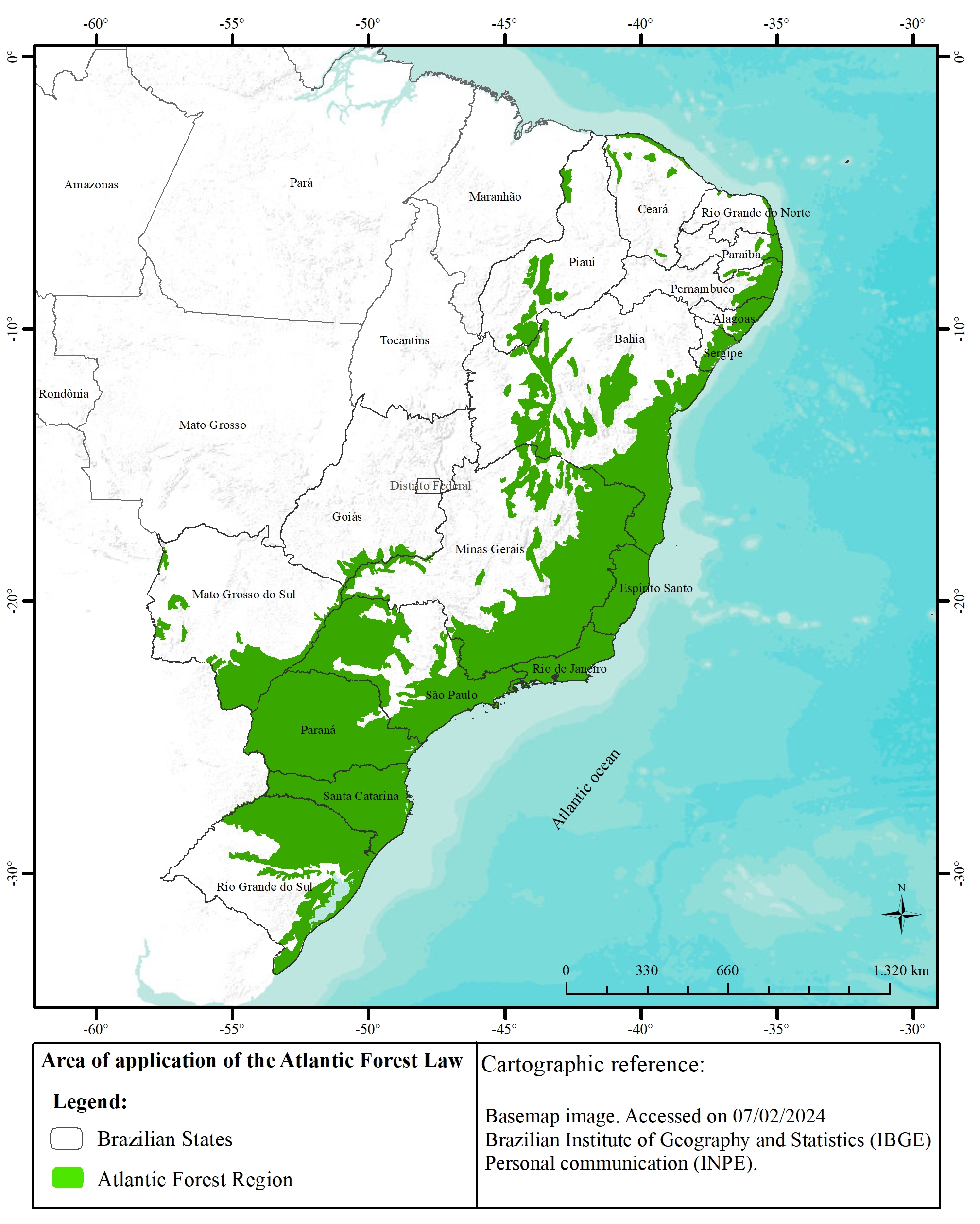
The boundary of the Atlantic Forest biome, as represented in the Map of Brazilian Biomes, covers an area of 1,110,182 km². This delimitation was updated by IBGE in 2019 as a result of improvements in research processes, literature review, and, most notably, field survey verification and consolidation at a 1:250,000 scale. This new scale, 20 times more detailed than the previous one, produced significant changes in the boundaries between biomes. In this study, both delimitation criteria of the Atlantic Forest were considered: (i) the area of application of the Atlantic Forest Law, as defined and published by IBGE (2012) (Figure 1); and (ii) the Atlantic Forest biome boundary represented in the Map of Brazilian Biomes, updated by IBGE in 2019, here referred to as the biome map (Figure 2).

Area of the Atlantic Forest Domain in Brazil, referred to as the area of application of the Atlantic Forest Law.

Methodological Procedures
Data Acquisition and Processing
The first step consisted of acquiring census data on the number of inhabitants in Brazil in 2022 and defining the geographic boundaries of the study area. For comparative purposes, both delimitation criteria of the Atlantic Forest biome were considered, allowing for a detailed analysis of their geographic differences and their relationship with population distribution.
Geographic information related to the delimitation of the study areas and the digital cartographic base were obtained from the TerraBrasilis platform of the National Institute for Space Research (INPE 2023) and from IBGE, using the 2019 Brazilian municipal meshes at a 1:250,000 scale, in shapefile format.
All data were georeferenced using the Universal Transverse Mercator (UTM) projection system, SIRGAS 2000 datum, with the support of QGIS software version 3.16.2. Subsequently, census data were integrated with geographic information using Microsoft Excel software.
Municipality Inclusion Criterion
Some municipalities located along the biome boundaries have part of their territories within the Atlantic Forest and part outside it. As this study adopted the criterion of summing the populations of municipalities encompassed by the biome, including all municipalities partially inserted would result in an overestimation of the population, while excluding them entirely would lead to an underestimation.
To address this issue, we opted to include only municipalities with 50% or more of their territory within the biome limits, excluding those with less than 50% overlap. As an example, Figure 3 shows that, when using either the Atlantic Forest Law area boundaries or the biome map limits, there are municipalities with less than 1% of their territories within the Atlantic Forest, making their inclusion in the analyses inadequate.

Examples of areas where the biome occupies less than 1% of the municipal territory, both for the Atlantic Forest Law area (a: Bom Jesus do Amparo, MG) and for the biome map boundary (b: Macambira, SE).
RESULTS
The census and geographic analyses conducted for the study areas allowed for the estimation of the number of inhabitants living within the Atlantic Forest biome based on the 2022 Census. The results are presented considering both biome boundaries.
The number of states and municipalities encompassed, even partially, by the Atlantic Forest boundaries was determined using IBGE data for 2022. Considering the boundary defined by the Atlantic Forest Law area, there are 17 states and 3,416 municipalities totally or partially included in the biome. For the boundary established by the biome map, there are 15 states and 3,082 municipalities.
Applying the municipality inclusion criterion adopted in this study, which excludes those with less than 50% of their territory within the biome, there are 17 states and 2,836 municipalities included under the boundary defined by the Atlantic Forest Law area. For the boundary established by the biome map, there are 15 states and 2,713 municipalities (Table I).
According to the 2022 Census, Brazil’s population totals 203,080,756 inhabitants, distributed across 26 states and 5,570 municipalities, occupying a territorial extension of 8,510,000 km² (IBGE 2023). The Southeast region concentrates 41.78% of the country’s population, followed by the Northeast with 26.91% and the South with 14.74%, while the North and Center-West regions together account for 16.57% of the Brazilian population.
The analysis of IBGE census data, associated with the study area boundaries and the adopted criterion, indicated that the number of inhabitants residing in the Atlantic Forest, considering the Atlantic Forest Law area, is 116,034,402 people, corresponding to 57.14% of the Brazilian population (Table II). For the boundary defined by the biome map (2019), the estimated population is 115,609,735 inhabitants, equivalent to 56.93% of the national population (Table III).
Number of inhabitants residing in the Atlantic Forest considering the area of application of the Atlantic Forest Law (2006) and the percentage relative to the country’s total population.
Number of inhabitants residing in the Atlantic Forest considering the biome map and the percentage relative to the country’s total population.
Despite the differences between the areas considered, both estimates indicate that approximately 57% of Brazil’s population lives within the region covered by the Atlantic Forest, whose area represents about 15% of the country’s territory.
Figure 4 shows the percentage of the population of each Brazilian region living within the biome boundaries. The data indicate that the proportion of inhabitants residing within the Atlantic Forest biome is highest in the Southeast Region, encompassing 82.96% of its inhabitants according to the Atlantic Forest Law area and 85.04% according to the biome map in 2019.

Percentage of the Brazilian population by region within the two established boundaries of the Atlantic Forest biome.
The South Region also shows a high proportion, with 84.29% of its inhabitants included according to the Atlantic Forest Law area and 79.01% according to the biome map in 2019. In contrast, the Northeast and Center-West regions have lower proportions of their populations within the biome, reflecting the smaller territorial extent of the biome in these regions.
A comparative analysis of the number of inhabitants by Brazilian state is illustrated in Figure 5. The data reveal that the state of São Paulo has the highest population representativeness within the Atlantic Forest biome. Among Brazilians living in the biome, 31.95% live in São Paulo, according to the Atlantic Forest Law area, and 34.55% according to the biome map.

Number of inhabitants by Brazilian state considering the Atlantic Forest Law area and the biome map.
Rio de Janeiro follows, encompassing 13.78% of the population living within the Atlantic Forest region, according to the law area, and 13.85% according to the biome map, followed by Minas Gerais with 11.66% and 10.67%, respectively.
On the other hand, the states of Mato Grosso do Sul and Goiás have the lowest population representation for both biome boundaries. According to the biome map, Mato Grosso do Sul accounts for only 0.30% of the population and Goiás 0.02%. For the law area, Mato Grosso do Sul represents 0.58% and Goiás 0.11%.
Law Application Area
Of the total number of municipalities included within the Atlantic Forest biome boundary defined by the Law Application Area, 4.5% were excluded based on the selection criterion adopted in this study, which considers only municipalities with 50% or more of their territory within the biome; in population terms, 7% of the total inhabitants residing in the Atlantic Forest, considering the same boundary, were excluded by the application of this criterion.
Within the boundaries established by the IBGE in 2006, based on the Law Application Area, the Atlantic Forest biome covers 15.4% of Brazil’s national territory, encompassing 17 states and 2,836 municipalities. Among all states within the biome, Minas Gerais stands out with 592 municipalities, followed by São Paulo with 473. The states of Piauí and Goiás show the lowest representation, with only 10 and 9 municipalities, respectively.
In this boundary, the biome is predominantly located in the South and Southeast regions of Brazil. In the South region, 84.29% of the population lives within the limits established by the Law Application Area. In the Southeast region, 82.96% of the population resides within the biome. In the Northeast, 35.90% of the population is located within the law’s boundaries, whereas in the Center-West region the representation is only 4.84%. These data are detailed in Figure 6.

Number of inhabitants by Brazilian state within the limits of the Atlantic Forest Biome, considering the Law Application Area (2006).
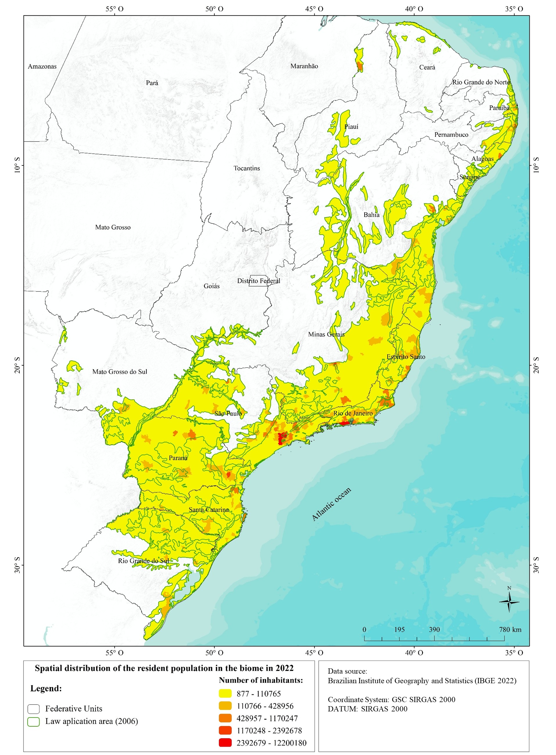
Figure 7 presents the spatial distribution of the resident population in 2022, by municipality, within the Atlantic Forest biome according to the boundary defined by the Law Application Area, highlighting the strong population concentration in the Southeast and South regions.

Resident population distribution in the Atlantic Forest biome (2022) based on the Law Application Area.
Biome Map
Of the total number of municipalities included within the Atlantic Forest biome boundary defined by the biome map, 8.85% were excluded based on the selection criterion adopted in this study; in population terms, 6.13% of the total inhabitants residing in the Atlantic Forest, considering the same boundary, were excluded by the application of the selection criterion.
According to the biome boundaries defined by the IBGE in 2019, the Atlantic Forest occupies 13% of Brazil’s national territory, encompassing 15 states and 2,713 municipalities. Similar to the Law Application Area, the states of Minas Gerais and São Paulo stand out, with 567 and 547 municipalities respectively, within the biome map limits. The states of Rio Grande do Norte and Goiás have the lowest representation, with only 11 and 3 municipalities, respectively.
Within this boundary, the biome is predominantly present in Brazil’s Southeast and South regions. In the Southeast, 85.04% of the population lives within the established limits. In the South, 79.04% of the population resides in the biome. In the Northeast, 35.55% of the population falls within the boundary, while in the Center-West region the representation is only 2.26%. These data are detailed in Figure 8.
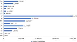
Number of inhabitants by Brazilian state within the limits of the Atlantic Forest Biome Map (2019).
Figure 9 presents the spatial distribution of the resident population in 2022, by municipality, within the Atlantic Forest biome according to the boundary defined by the biome map, highlighting the strong population concentration in the Southeast and South regions.

Distribution of the resident population within the Atlantic Forest biome (2022) based on the biome map.
DISCUSSION
The findings of this study provide methodologically explicit and updated estimates of the number of inhabitants living within the Atlantic Forest Biome, based on the 2022 Demographic Census and the two primary geographic boundaries of the biome: the Atlantic Forest Law Application Area in 2006 and the IBGE Biome Map in 2019.
The figures obtained — 116,07 million and 115,60 million inhabitants, respectively — correspond to approximately 57% of Brazil’s total population, confirming that more than half of Brazilians reside within the biome’s boundaries, even though it represents only about 15% of the national territory.
These updated estimates fill an important gap, as many widely cited figures — ranging between 60% and 72% (CI-Brasil et al. 2000, Pinto et al. 2006, Paglia & Pinto 2010, Marques & Grelle 2021) — lack methodological transparency. The inclusion criterion applied here, based on a minimum territorial overlap of 50%, contributed to reducing the overestimations found in studies that considered all municipalities with some overlap with the biome’s boudaries, resulting in more realistic values for environmental planning and public policy purposes.
The exclusion percentages observed as a result of applying the adopted selection criterion indicate that its impact on the final results is limited, demonstrating that most of the excluded municipalities have a small territorial share within the Atlantic Forest biome; thus, their removal helps to reduce potential population overestimation biases without substantially altering the demographic representativeness of the Atlantic Forest in the national context.
The regional analysis highlights an uneven population distribution within the biome. The Southeast and South regions concentrate most of the Atlantic Forest’s inhabitants, driven by large urban centers such as São Paulo and Rio de Janeiro, which historically developed in areas originally covered by Atlantic Forest. By contrast, the Northeast and Central-West regions show lower population representation, reflecting the biome’s limited territorial coverage in these regions or the predominance of other biomes, such as the Caatinga and Cerrado, in the location of their main urban areas.
This population concentration directly reflects the historical process of Brazilian urbanization, marked by the consolidation of the country’s main metropolitan regions within the Atlantic Forest domain, particularly in the Southeast Region. The formation and expansion of urban centers such as São Paulo and Rio de Janeiro were associated with the early occupation of the coastline and adjacent areas, resulting in high population density in areas originally covered by the biome.
This high population concentration in the Southeast and South exerts additional pressure on natural resources, intensifying problems such as water scarcity, watershed degradation, and increased vulnerability to extreme climate events (Lopes et al. 2022). This underscores the need to integrate demographic considerations into conservation and restoration strategies for the biome, given Brazil’s strong dependence on the ecosystem services provided by the Atlantic Forest, including water provision, climate regulation, agricultural pollination, soil protection, and cultural and recreational opportunities (Scarano 2017).
Although legal instruments and policies such as the Atlantic Forest Law (Brasil 2006), the Native Vegetation Protection Law (Brasil 2012), and the National System of Conservation Units (Brasil 2000) already represent significant advances, the high population density within the biome calls for approaches that reconcile conservation, ecological restoration, and sustainable development (Brancalion & Chazdon 2017). Furthermore, the concentration of large metropolitan areas within the biome requires solutions to mitigate socio-environmental impacts and promote climate resilience in urban regions.
It is important to highlight some limitations associated with the methodological approach adopted. The analysis is based on the total population of municipalities as the spatial unit. As a result, situations may occur in which municipalities excluded for having less than 50% of their territory within the biome still have a significant share of their population concentrated in the portion included in the Atlantic Forest. Nevertheless, the observed exclusion percentages indicate that the impact of this criterion on the final results is limited, contributing to the reduction of population overestimation. In addition, the data used do not allow for the inference of demographic dynamics, as components such as migration, fertility, and mortality are not considered, restricting the analysis to the resident population.
This study also highlights the importance of periodic monitoring based on updated census data and replicable geospatial methodologies, which allow for evaluating demographic dynamics within the biome over time. Future research could integrate socioeconomic and environmental variables, such as land use and land cover, urbanization patterns, and vulnerability indicators, enabling more detailed analyses of the relationships between human occupation, ecological integrity, and the provision of ecosystem services in the Atlantic Forest.
In summary, the data presented here demonstrate that a majority share of Brazil’s population lives in the Atlantic Forest and depends directly on the ecosystem services it provides. These findings reinforce the need for integrated public policies aimed not only at protecting the biome but also at ensuring the quality of life and socioecological resilience of the human populations that rely on it.
Acknowledgements
The authors thank the Programa de Capacitação Institucional (PCI), under the Ministry of Science, Technology and Innovation (MCTI) and the Conselho Nacional de Desenvolvimento Científico e Tecnológico (CNPq), for the financial and institutional support provided for the development of this work, under SEI/PCI process No. 01239.000274/2023-72.
References
-
BRANCALION PHS & CHAZDON RL. 2017. Beyond hectares: four principles to guide reforestation in the context of tropical forest and landscape restoration. Restor Ecol 25(4): 491-496. https://doi.org/10.1111/rec.12519.
» https://doi.org/10.1111/rec.12519 - BRASIL. 1988. Constituição da República Federativa do Brasil: promulgada em 5 de outubro de 1988.
- BRASIL. 2000. Lei n° 9.985, de 18 de julho de 2000. Regulamenta o art. 225, § 1°, incisos I, II, III e VII da Constituição Federal, institui o Sistema Nacional de Unidades de Conservação da Natureza e dá outras providências. Diário Oficial da União: seção 1, Brasília, DF, p. 1.
- BRASIL. 2006. Ministério do Meio Ambiente (MMA). Lei n° 11.428, de 22 de dezembro de 2006. Dispõe sobre a utilização e proteção da vegetação nativa do Bioma Mata Atlântica, e dá outras providências. Presidência da República, Casa Civil, Subchefi a para Assuntos Jurídicos, Brasília, DF.
- BRASIL. 2012. Lei n° 12.651, de 25 de maio de 2012. Dispõe sobre a proteção da vegetação nativa; altera as Leis n° 6.938, de 31 de agosto de 1981, n° 9.393, de 19 de dezembro de 1996, e n° 11.428, de 22 de dezembro de 2006; revoga as Leis n° 4.771, de 15 de setembro de 1965, e n° 7.754, de 14 de abril de 1989, e a Medida Provisória n° 2.166‑67, de 24 de agosto de 2001. Diário Oficial da União: seção 1, Brasília, DF, ano 149, n. 101, p. 1, 28 maio 2012.
- CAMPOS MC. 2011. Modernização da agricultura, expansão da soja no Brasil e astransformações socioespaciais no Paraná. Rev Geogr 6(1): 161-191.
- CI-BRASIL, FUNDAÇÃO SOS MATA ATLÂNTICA, FUNDAÇÃO BIODIVERSITAS, IPÊ, SECRETARIA DO MEIO AMBIENTE DO ESTADO DE SÃO PAULO & EMAD/IEF-MG. 2000. Avaliação e ações prioritárias para conservação da biodiversidade da Mata Atlântica e Campos Sulinos. MMA/SBF, Brasília.
- DEAN W. 1996. A ferro e fogo: a história e a devastação da mata atlântica brasileira. São Paulo: Companhia das Letras, 484 p.
- DENEVAN WM. 1992a. The pristine myth: the landscape of the Americas in 1492. Ann Am Assoc Geogr 82(3): 369-385.
- DENEVAN WM. 1992b. The Native Population of the Americas in 1492. 2nd revised ed., Madison: University of Wisconsin Press, 384 p.
- IBGE. 2012. Mapa da Área de Aplicação da Lei n° 11.428 de 2006. 1:5.000000.
-
IBGE. 2023. Censo Demográfico 2023. Available at: https://www.ibge.gov.br/estatisticas/sociais/saude/22827-censo-demografico-2022.html Accessed on June 4, 2024.
» https://www.ibge.gov.br/estatisticas/sociais/saude/22827-censo-demografico-2022.html -
IBGE & Ministério da Economia. 2019. Biomas e Sistema costeiro-marinho do Brasil: compatível com a escala 1:250.000. Série Relatórios Metodológicos volume 45. Rio de Janeiro, 168 p. (ISSN 0101-2843; v. 45). Available at: https://biblioteca.ibge.gov.br/visualizacao/livros/liv101676.pdf Accessed on July 5, 2024.
» https://biblioteca.ibge.gov.br/visualizacao/livros/liv101676.pdf -
INPE. 2023. Limites do Bioma Mata Atlântica. Available at: https://terrabrasilis.dpi.inpe.br/downloads/ Accessed on June 4, 2024.
» https://terrabrasilis.dpi.inpe.br/downloads/ - HELLIWELL DR. 1969. Valuation of wildlife resources. Reg Stud 3: 41-47.
-
LOPES BS, CORRÊA KAB, OGASAWARA MEK, PRECINOTO RS, CASSIANO CC, SELL BM, MELO RS, OLIVEIRA PCR & FERRAZ SFB. 2022. How does land use cover change affect hydrological response in the Atlantic Forest? Implications for ecological restoration. Front Water 4: 998349. https://doi.org/10.3389/frwa.2022.998349.
» https://doi.org/10.3389/frwa.2022.998349 -
MARQUES MCM & GRELLE CEV. 2021. The Atlantic Forest: History, Biodiversity, Threats and Opportunities of the Mega-diverse Forest. Springer Nature Switzerland. https://doi.org/10.1007/978-3-030-55322-7
» https://doi.org/10.1007/978-3-030-55322-7 - METZGER JP. 2009. Conservation issues in the Brazilian Atlantic Forest. Biol Conserv 142: 1138-1140.
-
MONGABAY BRASIL. 2024. Como o ecoturismo pode tornar a Mata Atlântica referência em sustentabilidade. Available at: https://brasil.mongabay.com/2024/01/como-o-ecoturismo-pode-tornar-a-mata-atlantica-referencia-em-sustentabilidade/ Accessed on July 10, 2025.
» https://brasil.mongabay.com/2024/01/como-o-ecoturismo-pode-tornar-a-mata-atlantica-referencia-em-sustentabilidade/ - NEVES WA ET AL. 2004. Early Holocene human skeletal remains from Cerca Grande, Lagoa Santa, Central Brazil, and the origins of the first Americans. World Archaeol 36(4): 479-501.
- OLIVEIRA RR. 2008. When the shifting agriculture is gone: functionality of Atlantic Coastal Forest in abandoned farming sites. Bol Mus Paraense Emílio Goeldi 3: 213-226.
- PAGLIA AP & PINTO LP. 2010. Biodiversidade da Mata Atlântica. In: Marone E, Riet D & Melo T (Eds), Brasil Atlântico – um país com a raíz na mata. Rio de Janeiro: Instituto BioAtlântica, p. 102-129.
-
PINTO LFG, METZGER JP & SPAROVEK G. 2022. Produção de Alimentos na Mata Atlântica: Desafios para uma agropecuária sustentável, saudável e com neutralização de carbono no bioma que é o maior produtor de alimentos no Brasil. SOS Mata Atlântica. Available at: https://cms.sosma.org.br/wp-content/uploads/2022/11/SOSMA_Produ%C3%A7%C3%A3o-de-Alimentos-na-Mata-Atl%C3%A2nticadigital.pdf Accessed on August 14, 2025.
» https://cms.sosma.org.br/wp-content/uploads/2022/11/SOSMA_Produ%C3%A7%C3%A3o-de-Alimentos-na-Mata-Atl%C3%A2nticadigital.pdf - PINTO LP, BEDÊ LC, PAESE A, FONSECA MT, PAGLIA AP & LAMAS IR. 2006. Mata Atlântica Brasileira: Os desafios para a conservação da Biodiverisdade em um hotspot mundial. In: Rocha CFD, Bergallo HG, Van Sluys M & Alves MAS (Eds), Conservação da Biodiversidade: Essências, p. 91-118.
-
RESENDE AF ET AL. 2024. How to enhance Atlantic Forest protection? Dealing with the shortcomings of successional stages classification. Perspect Ecol Conserv 22(2): 101-111. https://doi.org/10.1016/j.pecon.2024.04.002.
» https://doi.org/10.1016/j.pecon.2024.04.002 - RIBEIRO MC, MARTENSEN AC, METZGER JP, TABARELLI M, SCARANO FR & FORTIN MJ. 2011. The Brazilian Atlantic Forest: a shrinking biodiversity hotspot. In: Zachos FE & Habel JC (Eds), Biodiversity hotspots. Springer, Heidelberg, p. 405-434.
- SCARANO FR. 2017. Ecosystem-based adaptation to climate change: concept, scalability and a role for conservation science. Perspect Ecol Conserv 15(2): 65-73.
- SOLÓRZANO A, BRASIL LSCA & DE OLIVEIRA RR. 2021. The Atlantic Forest ecological history: from pre-colonial times to the Anthropocene. In: Marques MCM & Grelle CEV (Eds), The Atlantic Forest: History, Biodiversity, Threats and Opportunities of the Mega-diverse Forest. Cham: Springer Nature, p. 25-44.
-
SOS MATA ATLÂNTICA. 2022. Mata Atlântica, a floresta da população brasileira. Available at: https://www.sosma.org.br/artigos/mata-atlantica-a-floresta-da-populacaobrasileira/ Accessed on July 29, 2024.
» https://www.sosma.org.br/artigos/mata-atlantica-a-floresta-da-populacaobrasileira/ - VITULE JRS ET AL. 2021. Non-native Species Introductions, Invasions, and Biotic Homogenization in the Atlantic Forest. In: Marques MCM & Grelle CEV (Eds), The Atlantic Forest: History, Biodiversity, Threats and Opportunities of the Mega-diverse Forest. Cham: Springer Nature, p. 269-295.
- YOUNG CEF. 2006. Desmatamento e desemprego rural na Mata Atlântica. Flor Amb 13(2): 75-88.
-
WWF BRASIL. 2020. Dia da Mata Atlântica: saiba mais sobre o bioma onde 72% da população brasileira vive. Available at: https://www.wwf.org.br/?76362/Dia-da-Mata-Atlantica Accessed on July 10, 2025.
» https://www.wwf.org.br/?76362/Dia-da-Mata-Atlantica
Edited by
-
Handling editor
Alexander Kellner
The data that support the findings of this study are available from publicly accessible sources cited in the manuscript, including the Instituto Brasileiro de Geografia e Estatística and the Instituto Nacional de Pesquisas Espaciais TerraBrasilis platform.