
 Evaluation of the Vulnerability to Contamination of Groundwater in the Central Amazon, Santarém Region
ABSTRACT
In a context of rapid deforestation and agricultural expansion, the GOD (Groundwater type, Overall lithology of aquifer, and Depth of groundwater) approach can be used to identify areas most susceptible to diffuse contamination of the aquifer. We applied this approach to evaluate the intrinsic vulnerability to pollution of the Alter do Chão Aquifer System, located in the Santarém region (Pará State, Brazil). The parameters G (hydraulic confinement), O (lithology of overlying layers) and D (water table depth) were estimated using data from 41 boreholes from SIAGAS (Sistema de Informações de Águas Subterrâneas) and spatialized with interpolation via kriging. Results reveal predominantly low to moderate vulnerability (79% of the study area), with critical zones near the Tapajós and Amazon rivers (high to extreme vulnerability, 2.2%). The presence of Belterra clay significantly reduces risks in the central plateau. Methodological limitations, associated to data availability, highlight the need for enhanced monitoring networks. This mapping provides a decision-support tool for integrated groundwater management in the Amazon.
KEYWORDS:
physical geography; hydrogeology; sustainable groundwater management; confined aquifer; parametric method
RESUMO
Em um contexto de rápido desmatamento e expansão agrícola, a abordagem GOD (Ocorrência de água subterrânea ou tipo de aquífero, Litologia geral do aquífero e Profundidade do lençol freático) pode ser utilizada para identificar áreas mais suscetíveis à contaminação difusa do aquífero. Aplicamos essa abordagem para avaliar a vulnerabilidade intrínseca à poluição do Sistema Aquífero Alter do Chão, localizado na região de Santarém (Estado do Pará, Brasil). Os parâmetros G (confinamento hidráulico), O (litologia das camadas sobrejacentes) e D (profundidade do lençol freático) foram estimados utilizando dados de 41 poços do SIAGAS (Sistema de Informações de Águas Subterrâneas) e espacializados por interpolação via krigagem. Os resultados revelam vulnerabilidade predominantemente baixa a moderada (79% da área de estudo), com zonas críticas próximas aos rios Tapajós e Amazonas (vulnerabilidade alta a extrema alta, 2,2%). A presença da argila Belterra reduz significativamente os riscos no planalto central. Limitações metodológicas, associadas à disponibilidade de dados, destacam a necessidade de redes de monitoramento aprimoradas. Este mapeamento fornece uma ferramenta de apoio à tomada de decisões para a gestão integrada das águas subterrâneas na Amazônia.
PALAVRAS-CHAVE:
geografia física; hidrogeologia; gestão sustentável das águas subterrâneas; aquífero confinado; método paramétrico
INTRODUCTION
The Amazon River basin holds 16-18% of the world’s net freshwater (Latrubesse, 2008). Despite this abundance, these water resources have been threatened by land-use transformation, from natural vegetation to agriculture and mining over the past 50 years (Simon and Garagorry 2005; Nobre and Borma 2009; Müller et al. 2016; Souza et al. 2020). By 2020, the deforested area in the Amazon Biome had reached 729,781 km², corresponding to 17% of it (INPE 2020). Agricultural expansion causes pollution, particularly by pesticides, whose use is massive and poorly regulated in Brazil, and includes many persistent molecules with deleterious effects on health and the aquatic environment (Mello et al. 2020; Morgado et al. 2023). This non-point source agricultural pollution contaminates rivers and groundwater.
Despite the significant health and ecological problems caused by the emission of pollutants in agricultural areas, groundwater pollution in the Amazon remains insufficiently studied. The quantity and quality of groundwater in the Amazon are little known (ANA 2015; Rosário et al. 2016). Most of the available knowledge is concentrated in the Alter do Chão Aquifer System (Wahnfried and Soares 2012; Heerspink et al. 2020; Azevedo and Campos 2021), particularly in the Manaus and Santarém regions (Tancredi 1996; CPRM 2012; ANA 2015; Silva and Descovi Filho 2023).
Groundwater quality depends on the protective capacity of the pedological and geological environment (the soil-rock complex), and on land use in the aquifer recharge area. Thus, both the occurrence and the spatial distribution of soil and lithology must be considered to predict the polluting potential of a given use, and to design and implement effective management policies.
The concept of vulnerability has been used to express the ease or difficulty with which the physical environment can mitigate potential groundwater contamination by pollutants that infiltrate from the surface (Aller et al. 1987). It was coined by the French hydrogeologist Jean Margat (Margat, 1968). Pioneering works to assess groundwater vulnerability were undertaken in the USA by Le Grand (1964) and in France by Albinet (1970).
A significant number of methodologies to map groundwater vulnerability to contamination are available (Aller et al. 1987; Bachmat and Collin 1987; Ribeiro 2004). Two key approach types have been proposed to assess groundwater vulnerability and contaminant transfer (Lacroix et al. 2006). Both methods provide a fixed range of index values for any parameter considering the impact on groundwater vulnerability. The first type is a quantitative approach based on numerical modelling to replicate pollutant transport in unsaturated and saturated zones by considering the processes that control dispersion, diffusion and attenuation, of which the SWAT model (Arnold et al. 1998) or the MikeShe model (Refsgaard et al. 1999) are examples. These models are demanding in terms of data, time and expertise. The second type is based on indicators represented by parameters (Aller et al. 1987; Foster 1987). An overall assessment resulting from the sum of the parameters is mapped over a given area. The GOD (Foster 1987) and AVI (Stempvoort et al. 1993) are unweighted parametric methods. Based on a weighting, different parametric methods use a multiplier value for each parameter to emphasize the importance of a factor to the calculation of the weighted sum. Examples include the DAC, EPIK, DRASTIC and SINTACS methods. The DRASTIC and GOD methods are the most widely used in the world (Sarkar and Pal 2021; Cusano et al. 2023).
Based on a few parameters, recognized as determining factors, the GOD method is recommended by UNESCO for the favourable ratio between satisfactory quality of results and perceived ease of use with only three parameters. This paper analyses the suitability of the GOD method to characterize the Alter do Chão Aquifer System in the Santarém region.
MATERIALS AND METHODS
Study area
The research area is located in the state of Pará, central Amazonia (Figure 1), and covers the urban area of Santarém and the region on the right bank of the confluence of the Tapajós and the Amazon rivers. The climate in the region is tropical monsoon, type “Am” according to the Köppen classification. Average annual precipitation measured at the Santarém weather station is 2,150 mm (Climate-Data 2025).

Location map of the study area (Santarém region, central Amazon) with the potentiometric surface of the Alter do Chão Aquifer System.
The study area is entirely situated over the Alter do Chão Aquifer System and covers 14,216 km². The Alter do Chão Aquifer System is limited by the Guyana Craton to the north, by the Brazilian Craton to the south, by the Purus Arch (Solimões Basin) to the west, and by the Gurupá Arch (Marajó Basin) to the east, with an extension of 410,000 km² (Souza et al. 2013). The aquifer consists of a Cretaceous-Paleogene lithological sequence of fluvial sandy loam, intercalated with clays, conglomerates, and sandstones layers. The Alter do Chão formation is partially covered by more recent layers of duricrust and clay (Figure 2). In a large Amazonian area, Paleogene duricrust cap plateaus are carved by rivers (Rossetti 2004; Laurent et al. 2017). In the study area, the duricrust is frequently 5 m thick, and is mainly composed of bauxite, usually found in a nodular or columnar structure. Locally, the “Belterra Clay” covers the duricrust up to 15 m thick (Truckenbrodt et al. 1991). The lowlands near the Amazon river are formed by loamy-sand and clay alluvium. These geological characteristics are used to parametrize the GOD method.

Geology and observation wells. This map shows the geological units and wells found in the Santarém study area. Geological information was obtained from CPRM.
The most prevalent soils are Ferralsols. In the study area, soil textures are highly dependent on the nature of the bed rock and the topography (Sombroek 1966): on plateaus covered with Belterra clay, the soil is clayey; on the upper slopes of the valleys, it consists of gravel soils, formed by the dismantling of the duricrust; in the valley lower slopes and bottoms, it is loamy sand.
The Alter do Chão Aquifer System presents a mean thickness of 200 m and an effective porosity of 15-20% (Tancredi 1996; CPRM 2012; CPRM 2023). The hydraulic conductivity tests revealed values ranging from 5.0 x 10⁻⁵ to 2.1 x 10⁻⁴ m s-1 (Tancredi 1996).
A significant portion of the Belterra plateau is used for cultivating grain crops (soybean and maize) and for cattle farming. The west of the plateau and the main part of the Tapajós river border is a protected area, the Floresta Nacional do Tapajós.
GOD Method
The GOD method, initially proposed by Foster (1987), was improved by Foster and Hirata (1988), and uses two factors to determine aquifer pollution vulnerability: 1) the level of hydraulic inaccessibility of the saturated zone of the aquifer. It depends on groundwater confinement degree, depth to groundwater table or confined aquifer top and vertical hydraulic conductivity in vadose zone strata; 2) the contaminant attenuation capacity of the strata overlying the saturated aquifer. It depends on the consolidation or fissuring degree of the strata in vadose zone or confining beds and the lithological character of these strata (Foster et al. 2002).
The empirical methodology proposed here for the estimation of aquifer pollution vulnerability involved the following stages: 1) identification of the type of groundwater confinement - the G parameter, with ranking of this parameter on a scale of 0 - 1; 2) specification of the strata overlying the aquifer saturated zone - the O parameter, in terms of consolidation degree, presence or absence of fissure permeability, and type of lithology; this leads to a second score on a scale of 0.4 - 1.0; 3) estimation of the depth to groundwater table (of unconfined aquifers) or depth of first major groundwater strike (for confined aquifers) - the D parameter, with a ranking on a scale of 0.6 - 1.0 (Foster et al. 2002).
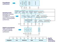
The GOD aquifer vulnerability index results from a multi-criteria sum. It is composed of three criteria: G, O, and D. The effect of each criterion is normalized on a scale of 0 to 1, with each parameter having the same weight in the multiplication. This yields a global vulnerability index representing vulnerabilities ranging from insignificant to very high. This is a qualitative method for interpreting the combination of the three most determining factors of the vulnerability to pollution. The “O” parameter is the most complex. Each well has a pedolithological profile with one or more layers in the unsaturated zone. Scores are assigned to each lithological type according to the logic presented in Figure 3. When two or more layers are present, a weighting is applied to calculate “O” based on their thickness in the unsaturated zone. Layers that attenuate pollutants to varying degrees are analyzed individually, on a case-by-case basis, generating weightings based on the type and thickness of layers in the unsaturated zone, as illustrated in the summary diagram of the GOD method (Figure 3).
Data
The used data were from a set of sample wells registered in the Groundwater Information System (Sistema de Informações de Águas Subterrâneas - SIAGAS) of the Brazilian Geological Service (CPRM 2023) (Table 1). Wells with water table different from zero that were recognized as upwelling were discarded. Finally, 41 points (Table S1) were chosen due to their reliability in describing the Alter do Chão Aquifer System.
We distinguished the Alter do Chão aquifer system from surface groundwater using data from tube wells (static level and geological profile) which provided representative information of the aquifer system and thus allowed us to keep only the data concerning the Alter do Chão aquifer. Among the available SIAGAS wells, we prioritized a broad and representative spatial distribution of tube wells. For each selected well, the geological profile showing the succession of textures and the measured groundwater depth was used to estimate the GOD parameters. The measurements available in the SIAGAS were acquired on different dates. Thus, seasonal fluctuations can influence the assessment of the piezometric level and thus the depth of water table used in GOD method. These constraints were disregarded in this study.
The Digital Elevation Model SRTM with a spatial resolution of 30 meters (NASA, 2023) was processed to obtain information on terrain altitude. Pre-existing vector data on geology, hydrography and administrative limits were also used (GADM 2023) (Table 1).
Application of the GOD method depends on the interpretation and scoring of each of its parameters. G (degree of hydraulic confinement of the aquifer) and O (type of pedological and lithological cover of the aquifer) were derived (interpreted) directly from each the 41 tube wells, from the observed lithology texture class series; D (Depth to the groundwater table) results from the depth directly measured in the tube well.
The values of the G parameter representing the degree of hydraulic confinement were interpreted based on the lithological profile and the existence and thickness of the impermeable layers, or layers with very low hydraulic conductivity, above the aquifer. When a clay layer two meters or more thick is present in the profile, we interpret that the aquifer at the well is “confined”. When a clayey-sandy or clayey-silty layer is several meters thick (from 2 meters), we interpret that the aquifer at the well is “semi-confined”. When the entire profile was formed of layers of sand, silty sand or clayey sand, and covered by a clayey soil, we interpret that the aquifer at the well is “unconfined (covered)”. And when the entire profile was formed of layers of sand, silty sand or clayey sand with a soil of the same nature on top, we interpret that the aquifer at the well is “unconfined”.
The values of the O parameter were interpreted from the lithological profile. We preferentially considered the layer with the lower hydraulic conductivity; thus when clay is present over several meters in the lithological profile, the value of O is considered low. The point coverage of G and O was transformed into raster data by ordinary kriging using no nugget, with predefined linear functions.
The potentiometric surface of the aquifer was mapped by kriging (predefined function spherical, cellsize 30 meters) the altitude of the static level observed in the wells and the altitude of the main rivers draining the water table (Amazon, Tapajós, Moju, Curuá-Una, Tutuí, Mojuí dos Campos and Uruará) from the SRTM raster to obtain the raster coverage of the static level. The D parameter raster area coverage was obtained by subtracting the potentiometric surface from the SRTM. Subsequently, each parameter was reclassified according to the correspondence values shown in Figure 4.

Potentiometric surface and equipotential lines in study area. This map shows the potentiometric surface in raster format and vector lines with the preferred direction of groundwater flows in the Santarém study region. The data were obtained from CPRM and geoprocessed using SAGA and QGIS.
Afterwards, the three parameters of the GOD method were mapped using the System for Automated Geoscientific Analyses (SAGA) (Conrad et al. 2015) utilizing the ordinary kriging interpolation method. The kriging method is efficient for spatializing hydrogeological data (Kumar and Remadevi 2006). A spatial resolution of 30 meters was used for the raster products considering the resolution of the DEM.
Finally, the GOD vulnerability index was generated by the product G x O x D within QGIS (QGIS, 2025), using Map algebra function. The resulting map was reclassified into the vulnerability intervals proposed by Foster (1987): 0.0 to 0.1 - Negligible; 0.1 to 0.3 - Low; 0.3 to 0.5 - Moderate; 0.5 to 0.7 - High; > 0.7 Extreme.
RESULTS
G - Groundwater hydraulic confinement
Of the 41 surveyed tube wells, 11 were located in an unconfined aquifer, 18 in a confined aquifer, eight were in a semi-confined aquifer, and four in an unconfined covered aquifer (covered by clayey soil). The degree of confinement map produced in this study (Figure 5a) shows a free aquifer along the Tapajós and Amazonas rivers, marking the western and northern boundaries of the study area, with vulnerability index exceeding 0.9. Areas of semi-confined to confined aquifers, with a G parameter less than 0.6, can be seen in the central and eastern parts of the study area.

Results of the application of the GOD method to the Alter do Chão Aquifer System in the Santarém region. A - Groundwater hydraulic confinement, estimated as the G parameter. B - Overlying strata, estimated as the O parameter. C - Depth to the groundwater table, estimated as the D parameter. D - Relief and groundwater table based in SRTM/NASA and CPRM. E - Vulnerability according to the GOD method. F - Groundwater pollution vulnerability classes GOD method (Foster 1987) that occur in the study area: 0.0 to 0.1 - Negligible; 0.1 to 0.3 - Low; 0.3 to 0.5 - Moderate and 0.5 to 0.7 - High.
O - Overlying strata
The spatialization indicates more protective soils and rocks of the vadose zone in the center of Santarém plateau (Figure 5b). In this plateau, the top layer of Belterra clay confers greater protection thanks to the lower hydraulic conductivity of this material, despite the moderate to high macroporosity of the kaolinitic soils (Truckenbrodt et al. 1991). In the South-Western part and South-Eastern part, as the Belterra clay is absent or thin, the O parameter is higher.
D - Depth to groundwater table
The region with the deepest groundwater table (up to 142 m), corresponding to a D value equal to 0.6, is the extreme eastern part of the study area (Figure 5c). The areas with the shallowest depth coincide with Tapajós and Amazonas rivers and with Curuá-Una river valley, in the west, north and central areas, respectively, where the aquifer is closest to the surface, directly connecting to the streams and rivers. To better understand the relation between topography and depth to the groundwater table, Figure 5d shows a schematic profile crossing the border of the plateau, until reaching the Amazon River plain, where the level is closer to the surface.
GOD estimates
The variance error analysis on the GOD values by observation well classified by confinement category shows that unconfined wells exhibit the highest mean GOD vulnerability index (0.397) and variance (0.0069), which indicates a greater susceptibility to contamination and variability. Confined wells show the lowest mean (0.076) and moderate variance (0.0036), thus reflecting better protection and consistency. Semi-confined and unconfined (covered) categories display intermediate values, with semi-confined having a lower variance (0.0026) compared to unconfined (covered) (0.0036). The Unconfined (covered) category had only four data points, which may skew results.
The GOD maps highlight the marked variability of vulnerability to pollution of the Alter do Chão Aquifer System in our study area, with magnification of - or compensation for - lithological and topographical features (Figures 5 e,f). The areas near the northern and southern banks of the Tapajós river are the most vulnerable. The vulnerability of the southwestern part of the Santarém plateau is moderate, while the central and eastern parts of this plateau are naturally well protected.
The predominance of areas with negligible vulnerability (11%) or low vulnerability (68%) in the study area is caused by the geological and topographical characteristics of a large part of the Santarém plateau, with a deep water table (low D parameter). In this portion of the plateau, the water table is covered in the vadose zone by a series of layers with a predominantly loamy sand composition. Some of them are clayey or clayey-sandy with low or medium hydraulic conductivity, where the plateau is covered with several meters Belterra clay (low O parameter). Also, the water table is frequently confined or semi-confined (low G parameter).
The medium and moderate vulnerability class, which accounts for about 17% of the area, occurs where the water table is not very deep (medium D parameter), the aquifer is semi-confined or not confined (medium to high G parameter) and/or has a thinner or no Belterra clay coverage (medium to high O parameter). The few highly vulnerable portions cover 2.15% of the study area. They appear in valley bottoms, near rivers, where the aquifer is unconfined (high G parameter), is not covered by clay (high O parameter) and the water table is shallow or outcropping (high D parameter).
DISCUSSION
We found a wide variation in the vulnerability of groundwater contamination in the Santarem region. Previous studies demonstrate a certain convergence with the vulnerability assessment carried out in the present study. Mapping results (Silva and Descovi Filho 2023), in a smaller area in the municipality of Santarém (which includes about 20% of the northern part of the area used for this study) are in accordance with the mapping of this study. Their study used a much denser sampling network (393 pumping wells, including 280 located in urban zones) but still the results are mostly in accordance with those found here, attesting to the capacity of the GOD method to provide reliable vulnerability assessments.
However, some limitations of the method should be mentioned. In the SIAGAS database, the potentiometric surface measurements were not conducted during the same season or year. Inaccuracies in the potentiometric map, and subsequently in the D map, may arise from this fact. This is inherent to the use of a public database composed of heterogeneous measurements. However, we presume that the temporal variations of the potentiometric level are still suitable for GOD mapping. First of all, since the Alter do Chão Aquifer System is a deep and large aquifer, seasonal variations in the potentiometric surface are assumed to be low. Second, the GOD method consists of classifying the data into categories; and its sensitivity to seasonal variations is assumed to be low compared to other uncertainties introduced by the classification process. The number of observation wells is insufficient over part of the study area, which makes the estimation of the parameters very uncertain in the south-western and south-eastern parts of the area. As we have previously pointed out, there is a low density of hydrogeological data in the Amazon. The resulting method maps should therefore be considered with caution. However, they present a hierarchy of vulnerability.
The hydrogeological database of wells must be updated, using field measurements, and be expanded to improve representativeness. The human population is quite unevenly distributed in this region, being mostly located in the vicinity of the Amazon and Tapajós rivers, this explains the higher density of wells in these areas. This contrasts with the extensive unpopulated forest and/or sparsely populated agricultural areas, which has few pumping wells with hydrogeological information. This situation limits the assessment of spatial variability vulnerability, whatever the kriging or interpolation method used. Also, field measurements are needed to check the consistency of the information concerning the location, status, lithology series and depth of the water table drilled for wells. Field measurements of potentiometric surface must be carried out during the same season to produce a more robust D-map.
A sensitive stage of the GOD method is the spatialization of point values by kriging. The quality of kriging depends on the method type, density and spatial distribution of measurement points, as well as on the complexity of the systems concerned. The Alter do Chão Aquifer System has been affected by post sedimentary tectonics with faults that separated large blocks (Vasquez et al. 2008). The absence or scarcity of data on this tectonic phenomenon may be a source of error in the vulnerability spatialization. Improving the mapping of the “O” (Overlying strata) in the GOD method by inserting geomorphostructures and regional tectonic compartmentalization could be the next step to match the simulations to the geological context.
Other potential issues include the lack of representation of shallow groundwater exploitation. In the study region it is locally exploited, but in the results, the vulnerability of the shallow aquifers is not represented for homogeneity reasons. Only the vulnerability of the Alter do Chão regional Aquifer System was modeled. Further studies are also recommended for a better understanding of the intercommunication between rivers (the Tapajós, Amazon and smaller rivers such as Curuá-Una), quaternary alluvial aquifers and the Alter do Chão Aquifer System.
To assess the aquifer risk to pollution, besides the intrinsic vulnerability, it is necessary to account for activities that involve a risk of contamination. To evaluate this risk, the vulnerability map could be overlaid on a map of pollution pressure associated with land use. The north-western banks of the river are major urbanized zones, in particular the Santarém urban area (population: 357,311; IBGE 2024) and the district of Alter do Chão (6,740 inhabitants). Urban areas have uncontrolled wastewater discharges, receiving both domestic and industrial contaminants. The Santarém plateau, to the south and south-east of the city, is intensively used for cattle breeding, soybean and corn crops. The use of pesticides can contaminate the aquifer, particularly in the valleys in the center of the plateau, which are particularly vulnerable since the depth of the aquifer is shallow, thus connecting groundwater with surface water. The resulting pollution vulnerability map could be used to protect water quality by conserving or restoring forests in the most vulnerable areas. Morgado et al. (2023) highlighted pesticide contamination of rivers and shallow groundwater in part of the study area. These pollutants could potentially infiltrate the Alter do Chão aquifer system.
A few other applications of the GOD method in the Amazon show medium to high vulnerability of the aquifers studied. Medium to high vulnerability was reported for the urban area of Belém, also using the SIAGAS database to analyse the vulnerability of shallow groundwater (Lisboa et al. 2020). The vulnerability of Rio Branco aquifer, Western Amazon, was assessed with the GOD method as high (Franco and Arcos 2023).
Low to medium vulnerability was found with the GOD method in three hydrogeological units of Abaetetuba, Eastern Amazon, highlighting the contradiction with observed contamination by coliforms in the majority of the wells (Leite et al. 2019). Despite its accuracy limitations, GOD remains one of the best spatial multi-criteria overlay methods, being suitable for data-limited regions that require rapid groundwater vulnerability assessment (Goyal et al. 2021).
This study represents the first comprehensive application of the GOD method to assess groundwater vulnerability in the Alter do Chão Aquifer System, a critical freshwater resource in the Brazilian Amazon. Our findings demonstrate that approximately 79% of the study area exhibits low to negligible vulnerability, primarily due to the protective combination of deep water tables (>100 m), semi-confined to confined aquifer conditions, and the presence of low-permeability Belterra clay layers. However, the identification of highly vulnerable zones (2.2% of the area) along river valleys and flood areas is increasingly being targeted for agricultural expansion.
The methodological approach proved particularly suitable for data-scarce Amazon environments, although three key limitations that should guide future research were identified: (1) temporal variations in groundwater levels were not captured due to variable monitoring periods. Although the RIMAS system allows this analysis, it would be very localized and could not be generalized to the entire area of study, (2) the spatial distribution of monitoring wells was insufficient to fully characterize hydrogeological heterogeneity, and (3) the assessment did not consider aquifer discontinuities, existence of hydrogeological compartments and other potential contaminant pathways related to tectonic discontinuities.
These results have immediate practical implications for land-use planning in the Santarém region. Three priority actions are recommended: (1) establishment of protection zones in high-vulnerability riparian areas, (2) integration of vulnerability mapping with pesticide use monitoring programs, and (3) expansion of the groundwater monitoring network with seasonal piezometric measurements. Future research should focus on more detailed characterization of the vadose zone hydrodynamics.
CONCLUSIONS
This study establishes a baseline for sustainable groundwater management in the Amazon that balances agricultural development with ecosystem protection. The methodology could be extended to other tropical aquifer systems facing similar pressures from land-use change, due to agricultural expansion. These areas require special attention.
ACKNOWLEDGMENTS
We would like to thank Conselho Nacional de Desenvolvimento Científico CNPq for funding (process 401015/2022-0).
REFERENCES
- Albinet, M. 1970. Les cartes de vulnérabilité des nappes d’eau souterraine à la pollution. Bureau de Recherches Géologiques et Minières (BRGM), Département d’Hydrogéologie, Service Géologique National, Rapport 70-SGN-325-HYD, Orléans, France. 40p.
- Aller, L.; Bennet, T.; Lehr, J.H.; Petty, R.J.; Hackett, G. 1987. DRASTIC: a standardized system for evaluating ground water pollution potential using hydrogeologic settings. EPA/600/2-87/035. Robert S. Kerr Environmental Research Laboratory, Office of Research and Development, U.S. Environmental Protection Agency, Ada, Oklahoma, USA. 641p.
- Arnold, J.G.; Srinivasan, R.; Muttiah, R.S.; Williams, J.R. 1998. Large area hydrologic modeling and assessment, Part 1: Model development. JAWRA 34: 73-90.
-
ANA. 2015. Avaliação dos Aquíferos das Bacias Sedimentares da Província Hidrogeológica Amazonas no Brasil Catálogo de Metadados da ANA. ( (https://metadados.snirh.gov.br/geonetwork/srv/api/records/07c7cf8f-6e81-4040-b405-8361f6b4cdf9 ) Accessed on 09 Mar 2024.
» https://metadados.snirh.gov.br/geonetwork/srv/api/records/07c7cf8f-6e81-4040-b405-8361f6b4cdf9 - Azevedo, J.H.; Campos, J.E.G. 2021. Flow patterns and aquifer recharge controls under Amazon rainforest influence: The case of the Alter do Chão aquifer system. Journal of South American Earth Sciences, 112: 103596.
- Bachmat, Y.; Collin, M. 1987. Mapping to assess groundwater’s vulnerability to pollution. In: Vulnerability of soil and groundwater to pollutants: International conference Verslagen en Mededelingen - Commissie voor Hydrologisch Onderzoek. T.N.O., 38: 297-307.
-
Climate-data. 2025. Clima: Santarém ( (https://pt.climate-data.org/america-do-sul/brasil/para/santarem-4352/ ) Accessed on 10 Mar 2025.
» https://pt.climate-data.org/america-do-sul/brasil/para/santarem-4352/ - Conrad, O.; Bechtel, B.; Bock, M.; Dietrich, H.; Fischer, E.; Gerlitz, L.; et al 2015. System for Automated Geoscientific Analyses (SAGA) v. 2.1.4. Geoscientific Model Development, 8: 1991-2007.
- CPRM. 2012. Serviço Geológico do Brasil. Projeto Rede Integrada de Monitoramento das Águas Subterrâneas: relatório diagnóstico. Aquífero Alter do Chão, Bacia Sedimentar do Amazonas Belo Horizonte: CPRM. v.7 47p.
-
CPRM. 2023. Serviço Geológico do Brasil. Sistema de Informações de Águas Subterrâneas - SIAGAS ( (https://siagasweb.sgb.gov.br/layout/pesquisa_complexa.php ) Accessed on 25 Oct 2024.
» https://siagasweb.sgb.gov.br/layout/pesquisa_complexa.php - Cusano, D.; Coda, S.; De Vita, P.; Fabbrocino, S.; Fusco, F.; Lepore, D.; et al 2023. A comparison of methods for assessing groundwater vulnerability in karst aquifers: The case study of Terminio Mt. aquifer (Southern Italy). Sustainable Environment Research, 33: 42.
- Foster, S. S. D. 1987. Fundamental concepts in aquifer vulnerability, pollution risk and protection strategy. In: Vulnerability of soil and groundwater to pollutants, International Conference Verslagen en Mededelingen - Commissie voor Hydrologisch Onderzoek T.N.O., 38: 69-86.
-
Foster, S. S. D.; Hirata, R. 1988. Groundwater pollution risk assessment: A methodology using available data. Pan American Center for Sanitary Engineering and Environmental Sciences (CEPIS). ( (http://bvsper.paho.org/bvsacd/scan/020059.pdf ) Accessed on 10 Oct 2024.
» http://bvsper.paho.org/bvsacd/scan/020059.pdf - Foster, S.; Hirata, R.; Gomes, D.; D’Elia, M.; Paris, M. 2002. Groundwater Quality Protection: A Guide for Water Utilities, Municipal Authorities, and Environment Agencies Washington, DC: World Bank. 114 p.
- Franco, A. de O.; Arcos, F. O. 2023. Natural vulnerability of aquifers and the potential contamination of groundwater resources in the State of Acre. Region - Water Conservancy, 6: 24-34.
-
GADM. 2023. GADM maps and data. Brazil. ( (https://gadm.org/maps/BRA.html ) Accessed on 19 Jan 2024.
» https://gadm.org/maps/BRA.html - Goyal, D.; Haritash, A. K.; Singh, S. K. 2021. A comprehensive review of groundwater vulnerability assessment using index-based, modelling, and coupling methods. Journal of Environmental Management, 296: 113161.
- Heerspink, B.P.; Kendall, A.D.; Coe, M.T.; Hyndman, D.W. 2020. Trends in streamflow, evapotranspiration, and groundwater storage across the Amazon Basin linked to changing precipitation and land cover. Journal of Hydrology: Regional Studies, 32: 100755.
-
IBGE. 2024. Estimativas da População ( (https://www.ibge.gov.br/estatisticas/sociais/populacao/9103-estimativas-de-populacao.html ) Accessed on 10 Apr 2024.
» https://www.ibge.gov.br/estatisticas/sociais/populacao/9103-estimativas-de-populacao.html -
INPE. 2020. PRODES - Coordenação-Geral de Observação da Terra ( (http://www.obt.inpe.br/prodes/ ) Accessed on 10 Jan 2025.
» http://www.obt.inpe.br/prodes/ -
Jarvis, A.; Guevara, E.; Reuter, H. I.; Nelson, A. D. 2008. Hole-filled SRTM for the globe: version 4: data grid. ( (http://srtm.csi.cgiar.org ) Accessed on 19 Jan 2025.
» http://srtm.csi.cgiar.org - Kumar, V.; Remadevi. 2006. Kriging of groundwater levels - A case study. Journal of Spatial Hydrology, 6: 81-94.
- Lacroix, A.; Laurent, F.; Ruelland, D.; Sauboua, E. 2006. Nitrate pollution risk assessment : From the model to the indicator. International Journal of Agricultural Resources, Governance and Ecology, 5: 206-223.
- Latrubesse, E. M. 2008. Patterns of anabranching channels: The ultimate end-member adjustment of mega rivers. Geomorphology, 101: 130-145.
- Laurent, F.; Poccard-Chapuis, R.; Plassin, S.; Pimentel Martinez, G. 2017. Soil texture derived from topography in North-eastern Amazonia. Journal of Maps, 13: 109-115.
- Leite, A.; Siqueira, G.; Darwich, A.; Aprile, F. 2019. Hydrogeological characteristic and the vulnerability degree of the aquifers from municipality of Abaetetuba, Pará -Brazil. Asian Journal of Geological Research, 2: 12-27.
- Le Grand, H. E. 1964. System for evaluation of contamination potential of some waste disposal sites. Journal American Water Works Association, 56: 959-974.
- Lisboa, É. G.; Mendes, R. L. R.; Figueiredo, M. M. P.; Bello, L. A. L. 2020. Fuzzy-probabilistic model for a risk assessment of groundwater contamination: application to an urban zone in the city of Belém, Pará, Brazil. Water, 12: 1437.
-
Margat, J. 1968. Vulnérabilité des nappes d’eau souterraine à la pollution: bases de sa cartographie Report nº 68 SGL 198 HYD. Orléans: Bureau de Recherches Géologiques et Minières (BRGM). ( (https://infoterre.brgm.fr/rapports/68-SGN-198-HYD.pdf ) Accessed on 12 Jun 2024.
» https://infoterre.brgm.fr/rapports/68-SGN-198-HYD.pdf - Mello, K. de; Taniwaki, R. H.; Paula, F. R. de; Valente, R. A.; Randhir, T. O.; Macedo, D. R.; et al 2020. Multiscale land use impacts on water quality: Assessment, planning, and future perspectives in Brazil. Journal of Environmental Management, 270: 110879.
- Morgado, M. G. de A.; Passos, C. J. S.; Garnier, J.; de Lima, L. A.; de Alcântara Mendes, R.; et al 2023. Large-scale agriculture and environmental pollution of ground and surface water and sediment by pesticides in the Brazilian Amazon: The Case of the Santarém Region. Water, Air, & Soil Pollution, 234: 150.
- Müller, H.; Griffiths, P.; Hostert, P. 2016. Long-term deforestation dynamics in the Brazilian Amazon-Uncovering historic frontier development along the Cuiabá-Santarém highway. International Journal of Applied Earth Observation and Geoinformation, 44: 61-69.
-
NASA. 2023. Earth Science Data Systems. Earthdata. ( (https://www.earthdata.nasa.gov/homepage ) Accessed on 19 Oct 2024.
» https://www.earthdata.nasa.gov/homepage - Nobre, C. A.; Borma, L. D. S. 2009. ‘Tipping points’ for the Amazon forest. Current Opinion in Environmental Sustainability, 1: 28-36.
-
QGIS Development Team. 2025. QGIS Geographic Information System (Version 3.40 6-Bratislava). Computer software. Open Source Geospatial Foundation Project. https://qgis.org
» https://qgis.org - Refsgaard, J.C.; Thorsen, M.; Jensen, J.B.; Kleeschlute, S.; Hansen, S. 1999. Large scale modelling of groundwater contamination for nitrate leaching. Journal of Hydrology, 221: 117-140.
- Ribeiro, L. F. 2004. Vulnerabilidade de aquíferos: conceitos, métodos e práticas FTD, Lisboa. 49p.
- Rosário, F.F. do; Custodio, E.; Silva, G.C. da. 2016. Hydrogeology of the Western Amazon aquifer system (WAAS). Journal of South American Earth Sciences, 72: 375-386.
- Rossetti, D. F. 2004. Paleosurfaces from northeastern Amazonia as a key for reconstructing paleolandscapes and understanding weathering products. Sedimentary Geology, 169: 151-174.
- Sarkar, M.; Pal, S. C. 2021. Application of DRASTIC and modified DRASTIC models for modeling groundwater vulnerability of Malda district in West Bengal. Journal of the Indian Society of Remote Sensing, 49: 1201-1219.
- Silva, Y.A.; Descovi Filho, L.L.V. 2023. Análise da vulnerabilidade intrínseca do Aquífero Alter do Chão no município de Santarém - Pará - Brasil In: David, M. E. V.; Chaves, C. L.; Milhomem Neto, J. M.; Gorayeb P. S. S. (Eds.). Contribuições à Geologia da Amazônia v.12. Sociedade Brasileira de Geologia - Núcleo Norte, Belém. p.212-225.
- Simon, M. F.; Garagorry, F. L. 2005. The expansion of agriculture in the Brazilian Amazon. Environmental Conservation, 32: 203-212.
- Sombroek, W. G. 1966. Amazon soils: a reconnaissance of the soils of the Brazilian Amazon region. PhD thesis. Wageningen University, Netherlands, 292 p.
- Souza, E. L.; Galvão, P. H. F; Pinheiro, C. S. S.; Baessa, M. P. M.; Demétrio, J. G. A.; Brito, W. R. R. 2013. Síntese da hidrogeologia nas bacias sedimentares do Amazonas e do Solimões: sistemas aquíferos Içá-Solimões e Alter do Chão. Geologia USP, Série Científica, 13: 107-117.
- Souza, C. M.; Z. Shimbo, J.; Rosa, M. R.; Parente, L. L.; A. Alencar, A.; Rudorff, B. F. T.; et al 2020. Reconstructing three decades of land use and land cover changes in Brazilian Biomes with Landsat archive and Earth Engine. Remote Sensing, 12: 2735.
- Stempvoort, D. V.; Ewert, L.; Wassenaar, L. 1993. Aquifer Vulnerability Index: a GIS - compatible method for groundwater vulnerability mapping. Canadian Water Resources Journal, 18: 25-37.
- Tancredi, A.C.F.N.S. 1996. Recursos hídricos subterrâneos de Santarém: fundamentos para uso e proteção PhD thesis, Universidade Federal do Pará, Belém. 146p.
- Truckenbrodt, W.; Kotschoubey, B.; Schellmann, W. 1991. Composition and origin of the clay cover on north Brazilian-laterites. Geologische Rundschau, 80: 591-610.
-
Vasquez, L. V.; Rosa-Costa, L. R.; Silva, C. G.; Ricci, P. F.; Barbosa, J. O.; Klein, E. L.; et al 2008. Geologia e recursos minerais do estado do Pará: Sistema de Informações Geográficas -SIG: Texto explicativo dos mapas geológico e tectônico e de recursos minerais do Estado do Pará. Escala, 1:1.000.000 RIGEO SGB CPRM. ( (https://rigeo.sgb.gov.br/bitstream/doc/10443/2/mapa_para.pdf ) Accessed on 29 Mar 2023.
» https://rigeo.sgb.gov.br/bitstream/doc/10443/2/mapa_para.pdf - Wahnfried, I.; Soares, E.A.A. 2012. Água subterrânea na Amazônia: Importância, estado atual do conhecimento e estratégias de pesquisa. Ciência & Ambiente, 44: 29-40.
Data availability
The data that support the findings of this study were published in this article and in the attached “Supplementary Material” section, and are public available at [SIAGAS/CPRM and SRTM/NASA] and can be accessed at [https://siagasweb.sgb.gov.br/layout/pesquisa_complexa.php and https://www.earthdata.nasa.gov/data/instruments/srtm].
SUPPLEMENTARY MATERIAL
Descovi Filho & Laurent. Vulnerability to contamination of groundwater in the Santarém region
Edited by
-
ASSOCIATE EDITOR:
Ingo Wahnfriedhttps://orcid.org/0000-0002-3427-9447


